

Surveyor General of the Northwest Territory
Encyclopedia
United States
The United States of America is a federal constitutional republic comprising fifty states and a federal district...
government official responsible for surveying land in the Northwest Territory
Northwest Territory
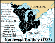
The Territory Northwest of the River Ohio, more commonly known as the Northwest Territory, was an organized incorporated territory of the United States that existed from July 13, 1787, until March 1, 1803, when the southeastern portion of the territory was admitted to the Union as the state of Ohio...
in the United States
United States
The United States of America is a federal constitutional republic comprising fifty states and a federal district...
late in the late eighteenth and early nineteenth century. The position was created in the Land Act of 1796 to survey lands ceded by Indians
Indigenous peoples of the Americas
The indigenous peoples of the Americas are the pre-Columbian inhabitants of North and South America, their descendants and other ethnic groups who are identified with those peoples. Indigenous peoples are known in Canada as Aboriginal peoples, and in the United States as Native Americans...
northwest of the Ohio River
Ohio River
The Ohio River is the largest tributary, by volume, of the Mississippi River. At the confluence, the Ohio is even bigger than the Mississippi and, thus, is hydrologically the main stream of the whole river system, including the Allegheny River further upstream...
and above the mouth of the Kentucky River
Kentucky River
The Kentucky River is a tributary of the Ohio River, long, in the U.S. state of Kentucky. The river and its tributaries drain much of the central region of the state, with its upper course passing through the coal-mining regions of the Cumberland Mountains, and its lower course passing through the...
. This act, and those that followed evolved into the Public Land Survey System
Public Land Survey System
The Public Land Survey System is a method used in the United States to survey and identify land parcels, particularly for titles and deeds of rural, wild or undeveloped land. Its basic units of area are the township and section. It is sometimes referred to as the rectangular survey system,...
.
Rufus Putnam
Rufus Putnam
Rufus Putnam was a colonial military officer during the French and Indian War, and a general in the Continental Army during the American Revolutionary War...
was appointed to the office in 1797, and held it until 1803. In 1801, the position was offered to Andrew Ellicott
Andrew Ellicott
Andrew Ellicott was a U.S. surveyor who helped map many of the territories west of the Appalachians, surveyed the boundaries of the District of Columbia, continued and completed Pierre Charles L'Enfant's work on the plan for Washington, D.C., and served as a teacher in survey methods for...
by Thomas Jefferson
Thomas Jefferson
Thomas Jefferson was the principal author of the United States Declaration of Independence and the Statute of Virginia for Religious Freedom , the third President of the United States and founder of the University of Virginia...
, but he refused, because he was upset at slow pay for work he had done for the Federal Government. Jared Mansfield
Jared Mansfield
300px|right|thumb|Sketch by [[Henry Howe]]Jared Mansfield was an American mathematician and surveyor. His career was shaped by two interventions by President Thomas Jefferson. In 1801 Jefferson appointed Mansfield as Professor at the newly-founded United States Military Academy at West Point...
held the office from 1803 to 1813. Josiah Meigs
Josiah Meigs
Josiah Meigs was an American academic, journalist and government official.-History:Meigs was the 13th and last child of Jonathan Meigs and Elizabeth Hamlin Meigs. His older brother was Return J. Meigs, Sr., whose son was Return J...
held office 1813 to 1815, and Edward Tiffin
Edward Tiffin
Edward Tiffin was a Democratic-Republican politician from Ohio, and first Governor of the state.-Biography:Sources indicate that he was born in Carlisle; however he may have been born in or near Workington — also in the then county of Cumberland, England...
from 1815 to his death in 1829. William Lytle served 1829 until his death in 1831. Micajah T. Williams held the office 1831 to 1834, when Robert Todd Lytle
Robert Todd Lytle
Robert Todd Lytle was a politician who represented Ohio in the United States House of Representatives from 1833 to 1835....
took over. Ezekiel S. Haines was appointed in 1838. Judge William Johnston held the office 1841-1845 as thanks for his efforts in supporting the Whig ticket in 1840.
The Surveyor General was initially paid $2000 per year, and his deputies were paid three dollars per mile surveyed.
Putnam was occupied in 1797 with laying off the Greenville Treaty Line and surveying the United States Military District
United States Military District
The United States Military District was a land tract in central Ohio that was established by the Congress to compensate veterans of the American Revolutionary War for their service...
and Moravian Indian Grants, and he started the survey of Congress Lands
Congress Lands
The Congress Lands was a group of land tracts in Ohio that made land available for sale to members of the general public through land offices in various cities, and through the General Land Office...
in 1798.
Mansfield is credited with "considerable scientific ability and high standards of workmanship." He laid out astronomically the Indiana
Indiana
Indiana is a US state, admitted to the United States as the 19th on December 11, 1816. It is located in the Midwestern United States and Great Lakes Region. With 6,483,802 residents, the state is ranked 15th in population and 16th in population density. Indiana is ranked 38th in land area and is...
baseline
Baseline (surveying)
In the United States Public Land Survey System, a baseline is the principal east-west line that divides survey townships between north and south. The baseline meets its corresponding meridian at the point of origin, or initial point, for the land survey...
and Second Principal Meridian
Second Principal Meridian
The Second Principal Meridian coincides with 86° 28' of longitude west from Greenwich, starts from a point two and one half miles west of the confluence of the Little Blue and Ohio rivers, runs north to the northern boundary of Indiana, and, with the base line in latitude 38° 28' 20", governs the...
, in spite of the difficulties. Pressures on him are illustrated in a letter Secretary of the Treasury Albert Gallatin
Albert Gallatin
Abraham Alfonse Albert Gallatin was a Swiss-American ethnologist, linguist, politician, diplomat, congressman, and the longest-serving United States Secretary of the Treasury. In 1831, he founded the University of the City of New York...
wrote to Mansfield: "The new act (March 13, 1805) is intended to palliate errors made in surveys north of the Ohio. At four dollars per mile, great correctness cannot be attained in that part of the country. Do your best at that price. Congress desires that corners and boundaries be definitely fixed, and the precise content of each is not equally important. A few acres more or less is not so important as it is that corners and boundaries should be known with precision to avoid litigation. It is of primary importance that the land should be surveyed and subdivided."
Tiffin established the scheme of guide meridians and standard parallels for townships distant from the principal meridians and baselines, which became a feature of the Public Land Survey System.
On March 3, 1803, a Surveyor General position was created for lands south of Tennessee
Tennessee
Tennessee is a U.S. state located in the Southeastern United States. It has a population of 6,346,105, making it the nation's 17th-largest state by population, and covers , making it the 36th-largest by total land area...
, and there followed a number of similar positions over the next years. In 1822, the first surveying district was created, namely the state of Ohio
Ohio
Ohio is a Midwestern state in the United States. The 34th largest state by area in the U.S.,it is the 7th‑most populous with over 11.5 million residents, containing several major American cities and seven metropolitan areas with populations of 500,000 or more.The state's capital is Columbus...
, with an officer called Surveyor-General in charge.
Until the reorganization of the General Land Office
General Land Office
The General Land Office was an independent agency of the United States government responsible for public domain lands in the United States. It was created in 1812 to take over functions previously conducted by the United States Department of the Treasury...
in 1836, each Surveyor General acted more or less independently, setting his own standards for execution of field work.