
Survey of English Dialects
Encyclopedia
The Survey of English Dialects was undertaken between 1950 and 1961 under the direction of Professor Harold Orton
of the English department of the University of Leeds
. It aimed to collect the full range of speech in England and Wales before local differences were to disappear. Standardisation of the English language was expected with the post-war increase in social mobility
and the spread of the mass media. The project originated in discussions between Professor Orton and Professor Eugen Dieth
of the University of Zurich
about the desirability of producing a linguistic atlas of England in 1946, and a questionnaire containing 1,300 questions was devised between 1947 and 1952.
and some areas of Wales that were located close to the English border. Priority was given to rural areas with a history of a stable population. When selecting speakers, priority was given to men, to the elderly and to those who worked in the main industry of the area, for these were all seen as traits that were connected to use of local dialect. One field worker gathering material claimed they had to dress in old clothes to gain the confidence of elderly villagers. Most of the recordings are of inhabitants discussing their local industry, but one of the richest dialects found in the survey, that at Skelmanthorpe in West Yorkshire, discussed a sighting of a ghost.
The literature usually refers to the "four urban sites" of Hackney
, Leeds
, Sheffield
and York
. The survey does seem to have been generally more urban-focused in West Yorkshire
. The sites Carlton, Thornhill and Wibsey were within the then boundaries of Pontefract, Dewsbury and Bradford respectively. Also, Ecclesfield and Golcar were urban districts in the West Riding. Outside London and West Yorkshire, nowhere near to a large city was examined.
The basic material had been written using specialised phonetic shorthand unintelligible to the general reader: in 1975 a more accessible book, A Word Geography of England was published. Harold Orton died soon after this in March, 1975.
The Linguistic Atlas of England was published in 1978, edited by Orton, John Widdowson and Clive Upton. Two further publications have been produced from the survey's material, Survey of English Dialect: the Dictionary and Grammar (1993) and An Atlas of English Dialects (1996), both co-authored by Upton and Widdowson.
in the North Riding of Yorkshire.
Monmouthshire
NEWLIN
awarded a grant to a team led by Sally Johnson, Professor of Linguistics and Phonetics at Leeds University to study British regional dialects.
Johnson's team are sifting through a large collection of examples of regional slang words and phrases turned up by the "Voices project" run by the BBC, in which the BBC invited the public to send in examples of English still spoken throughout the country. The BBC Voices project also collected hundreds of news articles about how the British speak English from swearing through to items on language schools. This information will also be collated and analysed by Johnson's team both for content and where it was reported. "Perhaps the most remarkable finding in the Voices study is that the English language is as diverse as ever, despite our increased mobility and constant exposure to other accents and dialects through television and radio." Work by the team on is project not expected to end before 2010.
and expressions from the BBC Voices project which is currently being studied by the Leeds University team(2007-2020).
Harold Orton
Harold Orton was an English university lecturer and dialectologist, best remembered as co-founder of the Survey of English Dialects . Orton developed the questionnaire for the survey together with Eugen Dieth...
of the English department of the University of Leeds
University of Leeds
The University of Leeds is a British Redbrick university located in the city of Leeds, West Yorkshire, England...
. It aimed to collect the full range of speech in England and Wales before local differences were to disappear. Standardisation of the English language was expected with the post-war increase in social mobility
Social mobility
Social mobility refers to the movement of people in a population from one social class or economic level to another. It typically refers to vertical mobility -- movement of individuals or groups up from one socio-economic level to another, often by changing jobs or marrying; but can also refer to...
and the spread of the mass media. The project originated in discussions between Professor Orton and Professor Eugen Dieth
Eugen Dieth
Eugen Dieth was a Swiss linguist, phonetician and dialectologist. He is well-known for his work in English and German phonetics, and for co-initiating the Survey of English Dialects....
of the University of Zurich
University of Zurich
The University of Zurich , located in the city of Zurich, is the largest university in Switzerland, with over 25,000 students. It was founded in 1833 from the existing colleges of theology, law, medicine and a new faculty of philosophy....
about the desirability of producing a linguistic atlas of England in 1946, and a questionnaire containing 1,300 questions was devised between 1947 and 1952.
Methodology
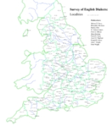
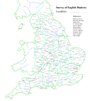
313 localities were selected from England, the Isle of ManIsle of Man
The Isle of Man , otherwise known simply as Mann , is a self-governing British Crown Dependency, located in the Irish Sea between the islands of Great Britain and Ireland, within the British Isles. The head of state is Queen Elizabeth II, who holds the title of Lord of Mann. The Lord of Mann is...
and some areas of Wales that were located close to the English border. Priority was given to rural areas with a history of a stable population. When selecting speakers, priority was given to men, to the elderly and to those who worked in the main industry of the area, for these were all seen as traits that were connected to use of local dialect. One field worker gathering material claimed they had to dress in old clothes to gain the confidence of elderly villagers. Most of the recordings are of inhabitants discussing their local industry, but one of the richest dialects found in the survey, that at Skelmanthorpe in West Yorkshire, discussed a sighting of a ghost.
The literature usually refers to the "four urban sites" of Hackney
London Borough of Hackney
The London Borough of Hackney is a London borough of North/North East London, and forms part of inner London. The local authority is Hackney London Borough Council....
, Leeds
Leeds
Leeds is a city and metropolitan borough in West Yorkshire, England. In 2001 Leeds' main urban subdivision had a population of 443,247, while the entire city has a population of 798,800 , making it the 30th-most populous city in the European Union.Leeds is the cultural, financial and commercial...
, Sheffield
Sheffield
Sheffield is a city and metropolitan borough of South Yorkshire, England. Its name derives from the River Sheaf, which runs through the city. Historically a part of the West Riding of Yorkshire, and with some of its southern suburbs annexed from Derbyshire, the city has grown from its largely...
and York
York
York is a walled city, situated at the confluence of the Rivers Ouse and Foss in North Yorkshire, England. The city has a rich heritage and has provided the backdrop to major political events throughout much of its two millennia of existence...
. The survey does seem to have been generally more urban-focused in West Yorkshire
West Yorkshire
West Yorkshire is a metropolitan county within the Yorkshire and the Humber region of England with a population of 2.2 million. West Yorkshire came into existence as a metropolitan county in 1974 after the passage of the Local Government Act 1972....
. The sites Carlton, Thornhill and Wibsey were within the then boundaries of Pontefract, Dewsbury and Bradford respectively. Also, Ecclesfield and Golcar were urban districts in the West Riding. Outside London and West Yorkshire, nowhere near to a large city was examined.
Publication of material
404,000 items of information were gathered, and these were published as thirteen volumes of "basic material" beginning in 1962. The process took many years, and was prone to funding difficulties on more than one occasion.The basic material had been written using specialised phonetic shorthand unintelligible to the general reader: in 1975 a more accessible book, A Word Geography of England was published. Harold Orton died soon after this in March, 1975.
The Linguistic Atlas of England was published in 1978, edited by Orton, John Widdowson and Clive Upton. Two further publications have been produced from the survey's material, Survey of English Dialect: the Dictionary and Grammar (1993) and An Atlas of English Dialects (1996), both co-authored by Upton and Widdowson.
Archive material
A large amount of "incidental material" from the survey was not published. This is preserved at the Leeds Archive of Vernacular Culture, part of the School of English of the University of Leeds. An entire book was written based in part on the findings at EgtonEgton
Egton is a village and civil parish in the Scarborough district of North Yorkshire, England about west of Whitby. There is a nearby village called Egton Bridge which is home to Egton railway station. The village was included in the Survey of English Dialects. Unlike the other sites, a full book...
in the North Riding of Yorkshire.
Sites for the survey
During the survey, each locality was given an identifying abbreviation, which is given in brackets.Wales
Flintshire- HanmerHanmerHanmer is a village and a local government community, the lowest tier of local government, part of Wrexham County Borough in Wales. At the 2001 Census the population of the Hanmer community area, which includes Hanmer village itself, Horseman's Green and Arowry along with a number of small hamlets,...
(Ch6)
Monmouthshire
- LlanellenLlanellenLlanellen is a village in Monmouthshire, south east Wales, United Kingdom.- History & Amenities :The Monmouthshire and Brecon Canal passes through Llanellen. The Blorenge mountain towers above the village. The River Usk passes close by.-External links:...
(Mon2) - Llanfrechfa (Mon5)
- NewportNewportNewport is a city and unitary authority area in Wales. Standing on the banks of the River Usk, it is located about east of Cardiff and is the largest urban area within the historic county boundaries of Monmouthshire and the preserved county of Gwent...
(Mon7) - Raglan, MonmouthshireRaglan, MonmouthshireRaglan is a village in Monmouthshire, south east Wales, United Kingdom. It is located some 9 miles south-west of Monmouth, midway between Monmouth and Abergavenny on the A40 road very near to the junction with the A449 road...
(Mon3) - CrosskeysCrosskeysCrosskeys is a small village in Caerphilly county borough in Wales.- Location :Crosskeys is seven miles north west of Newport, just past Risca off the A467 road. Located near to the confluence of the Ebbw River and the Sirhowy River, it was originally called Pont-y-cymer...
(Mon4) - ShirenewtonShirenewtonShirenewton is a village in Monmouthshire, south east Wales, UK. It is located 3 miles due west of Chepstow, 5 miles by road. The village stands around 500 feet above sea level, and has extensive views of the Severn Estuary and Bristol Channel....
(Mon6) - SkenfrithSkenfrithSkenfrith is a small village in Monmouthshire, south-east Wales, in the United Kingdom. It is located on the River Monnow, close to the border between Wales and England, about 6 miles north-west of Monmouth.- History and amenities :...
(Mon1)
England
Bedfordshire
Berkshire
Buckinghamshire
Cambridgeshire
Cheshire
Cornwall
Cumberland
Derbyshire
Devon
Dorset
|
Portesham Portesham is a village in the English county of Dorset, situated close to the south coast, between the towns of Weymouth and Dorchester. The village has a population of 708... (Do4) Sixpenny Handley Sixpenny Handley is a village and civil parish in north east Dorset, England, situated on Cranborne Chase ten miles north east of Blandford Forum... (Do1) Whitchurch Canonicorum Whitchurch Canonicorum or Whitechurch Canonicorum is a village in south-west Dorset, England, situated in the Marshwood Vale five miles northwest of Bridport.The village has a population of 647 ; 10.1% of dwellings are second homes... (Do3) Durham
Essex
Gloucestershire
Hampshire
Herefordshire
Hertfordshire
Huntingdonshire
Isle of Wight
|
Kent
Lancashire
Leicestershire
Lincolnshire
Middlesex
Norfolk
|
Gooderstone Gooderstone is a village situated in the Breckland District of Norfolk and covers an area of with an estimated population of 390 as of 2007. It lies south west from Swaffham.Gooderstone is served by St.Georges church in the Benefice of Cockley Cley.... (Nf8) Great Snoring Great Snoring is a rural village in North Norfolk by the River Stiffkey, in the east of England. Its population in the 2001 census was 168, a dramatic decrease since 1841 when it was 556 .At the centre of the village is the 13th century St. Mary's Church and the Old Rectory... (Nf2) Grimston, Norfolk Grimston is a civil parish in the English county of Norfolk approximately 6 miles north-east of King's Lynn.It covers an area of and had a population of 1,952 in 823 households as of the 2001 census.... (NF4) Ludham Ludham is a village and civil parish in the English county of Norfolk, in The Broads, at the end of a dyke leading to Womack Water and flowing into the River Thurne... (Nf6) North Elmham North Elmham is a village and civil parish in the English county of Norfolk.It covers an area of and had a population of 1,428 in 624 households as of the 2001 census. For the purposes of local government, it falls within the district of Breckland.... (Nf5) Outwell Outwell is a village and a civil parish in the English county of Norfolk The village is west of Norwich, south-west of King's Lynn and north of London. The nearest town is Wisbech which is north west of the village. The Village is on the route of the A1101 Bury St. Edmunds to Long Sutton road... (Nf7) Pulham St Mary Pulham St Mary is a village in Norfolk, approximately east of Diss and south of Norwich. It covers an area of and had a population of 866 in 365 households as of the 2001 census.... (Nf12) Reedham, Norfolk Reedham is a village and civil parish in the English county of Norfolk and within The Broads. It is situated on the north bank of the River Yare, some east of the city of Norwich, south-west of the town of Great Yarmouth and the same distance north-west of the Suffolk town of Lowestoft.The Romans... (Nf11) Northamptonshire
Northumberland
Nottinghamshire
Oxfordshire
Rutland
Shropshire
Somerset
|
Horsington, Somerset Horsington is a village and parish in Somerset, England, situated south of Wincanton and north of Templecombe in the South Somerset district. The village lies on the edge of Horsington Marsh, part of the Blackmore Vale... (So11) Merriott Merriott is a village and civil parish in Somerset, England, near the town of Crewkerne and west of Yeovil in the South Somerset district. The village has a population of 2,020.... (So13) Pitminster Pitminster is a village and civil parish in Somerset, England, situated south of Taunton in the Taunton Deane district. The village has a population of 929. The parish also includes the villages of Angersleigh, Blagdon or Blagdon Hill and Staplehay... (So12) Stogumber Stogumber is a village and civil parish in Somerset, England, on the eastern flank of the Brendon Hills. Besides Stogumber village itself, the parish includes the hamlets of Ashbeer, Capton, Escott, Higher Vexford, Kingswood, Lower Vellow, Lower Vexford, Preston, and Vellow.-History:The name comes... (So7) Stogursey Stogursey is the name of a small village and civil parish in the Quantock Hills in Somerset, England. It is situated from Nether Stowey, and west of Bridgwater... (So6) Stoke St Gregory Stoke St Gregory is a village and civil parish in Somerset, England, situated east of Taunton in the Taunton Deane district. The parish has a population of 920, and includes the hamlet of Stathe.-History:... (So10) Wedmore Wedmore is a village and civil parish in the county of Somerset, England. It is situated on raised ground, in the Somerset Levels between the River Axe and River Brue, often called the Isle of Wedmore. It forms part of Sedgemoor district... (So3) Weston There are many places called Weston:-Australia:* Weston, Australian Capital Territory* Weston Creek, Canberra* Weston Park, Canberra* Weston, New South Wales, a suburb of the City of Cessnock-Canada:* Weston, Nova Scotia* Weston, Ontario... (So1) Withypool Withypool is a small village in Somerset, England, near the centre of Exmoor National Park and close to the border with Devon. The word Withy means Willow... (So8) Wootton Courtenay Wootton Courtenay is a village and civil parish on Exmoor in the West Somerset district of Somerset, England. The parish includes the village of Huntscott.-History:Wootton was part of the hundred of Carhampton.-Governance:... (So5) Staffordshire
Suffolk
Surrey
Sussex
Warwickshire
|
Westmorland
Wiltshire
Worcestershire
Yorkshire
|
Voices survey 2007-2010
Following the last Survey of English Dialects, the University of Leeds has started work on a new project. In May 2007 the Arts and Humanities Research CouncilArts and Humanities Research Council
Established in April 2005 as successor to the Arts and Humanities Research Board, the Arts and Humanities Research Council is a British Research Council and non-departmental public body that provides approximately £102 million from the Government to support research and postgraduate study in the...
awarded a grant to a team led by Sally Johnson, Professor of Linguistics and Phonetics at Leeds University to study British regional dialects.
Johnson's team are sifting through a large collection of examples of regional slang words and phrases turned up by the "Voices project" run by the BBC, in which the BBC invited the public to send in examples of English still spoken throughout the country. The BBC Voices project also collected hundreds of news articles about how the British speak English from swearing through to items on language schools. This information will also be collated and analysed by Johnson's team both for content and where it was reported. "Perhaps the most remarkable finding in the Voices study is that the English language is as diverse as ever, despite our increased mobility and constant exposure to other accents and dialects through television and radio." Work by the team on is project not expected to end before 2010.
See also
- Survey of Anglo-Welsh DialectsSurvey of Anglo-Welsh DialectsThe Survey of Anglo-Welsh Dialects was commenced in 1968 under the direction of David Parry of University College, Swansea. The aim was to record the "conservative forms" of Welsh English spoken in rural locations in Wales. The methodology was based on that used in the Survey of English Dialects...
- CockneyCockneyThe term Cockney has both geographical and linguistic associations. Geographically and culturally, it often refers to working class Londoners, particularly those in the East End...
- Cumbrian dialectCumbrian dialectThe Cumbrian dialect is a local English dialect spoken in Cumbria in northern England, not to be confused with the extinct Celtic language Cumbric that used to be spoken in Cumbria. As in any county, there is a gradual drift in accent towards its neighbours...
- East Anglian EnglishEast Anglian EnglishEast Anglian English is a dialect of English spoken in East Anglia. This easternmost area of England was probably home to the first-ever form of language which can be called English...
- East Midlands EnglishEast Midlands EnglishEast Midlands English is a dialect traditionally spoken in those parts of English Midlands lying East of Watling Street...
- PitmaticPitmaticPitmatic , also colloquially known as "yakka", is a dialect of English used in the counties of Northumberland and Durham in England. It developed as a separate dialect from Northumbrian and Geordie partly due to the specialised terms used by mineworkers in the local coal pits...
- Welsh EnglishWelsh EnglishWelsh English, Anglo-Welsh, or Wenglish refers to the dialects of English spoken in Wales by Welsh people. The dialects are significantly influenced by Welsh grammar and often include words derived from Welsh...
- West Country dialectsWest Country dialectsThe West Country dialects and West Country accents are generic terms applied to any of several English dialects and accents used by much of the indigenous population of South West England, the area popularly known as the West Country....
- West Midlands EnglishWest Midlands EnglishWest Midlands English is a group of dialects of the English language. The accent has experienced ridicule within the UK for its unusual sound. The accent is a result of extensive migration to the region during the Industrial revolution...
- Yorkshire dialect and accentYorkshire dialect and accentThe Yorkshire dialect refers to the varieties of English used in the Northern England historic county of Yorkshire. Those varieties are often referred to as Broad Yorkshire or Tyke. The dialect has roots in older languages such as Old English and Old Norse; it should not be confused with modern slang...
Further reading
- Sounds Familiar? Listen to examples of regional accents and dialects from across the UK on the British Library's 'Sounds Familiar' website
- The Survey of English Dialects (University of Leeds)
- The Survey of English Dialects (Yorkshire Dialect Society)
- Extracts from the survey (British Library)
- McSmith, Andy. Dialect researchers given a 'canny load of chink' to sort 'pikeys' from 'chavs' in regional accents, The IndependentThe IndependentThe Independent is a British national morning newspaper published in London by Independent Print Limited, owned by Alexander Lebedev since 2010. It is nicknamed the Indy, while the Sunday edition, The Independent on Sunday, is the Sindy. Launched in 1986, it is one of the youngest UK national daily...
, 1 June 2007, Page 20. Includes a list of regional words
and expressions from the BBC Voices project which is currently being studied by the Leeds University team(2007-2020).