

Surobi District
Encyclopedia
This article is about the Surobi District of Kabul Province
. For the district in Paktika, see Sarobi, Paktika.
Surobi, Sarobi or Sarubi District is a district of Kabul Province
, Afghanistan
. Its capital, Surobi
, lies about 60 kilometres east of Kabul
along the A01 highway, although much of the district lies northeast of Kabul.The principal river is the Kabul River
. Many of the Uzbek IMU figters are said to come from Sarobi District, with the village of Basra being the headquarters of the Khalid bin Walid training camp.
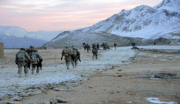
Sarobi was the site of a major action by the French Foreign Legion in December, 2009.
 Like in the rest of Afghanistan, no exact population numbers are available. The Afghan Ministry of Rural Rehabilitation & Development (MRRD) along with UNHCR and Central Statistics Office (CSO) of Afghanistan estimates the population of the district to be around 44,871. According to AIMS and UNHCR, Pashtuns
make up over 90% of the total population, while ethnic Pashai
s make up the remaining 10% of the population.
and Deh Sabz
districts to the west, Parvan
and Kapisa
provinces to the north, Laghman Province to the east, and Nangarhar Province
and Khaki Jabbar District
to the south.
There are 130 villages in Surobi district. The Kabul River
travels through the centre of the district and keeps the two sides of the district quite green. Three dam
s (Naghlo Dam, Mahipar Dam and Barqi-Sarobi Dam) are in the district, which generate electricity for Kabul and the district itself. However, due to lack of water, Mahipar Dam is out of order for now. Each village has their own governor or leader of that village.
Kabul Province
Kābul , situated in the east of the country, is one of the thirty-four provinces of Afghanistan. The capital of the province is Kabul City, which is also Afghanistan's capital. The population of Kabul province is 3.5 million people as of 2009, of which almost 80 percent live in the urban areas...
. For the district in Paktika, see Sarobi, Paktika.
Surobi, Sarobi or Sarubi District is a district of Kabul Province
Kabul Province
Kābul , situated in the east of the country, is one of the thirty-four provinces of Afghanistan. The capital of the province is Kabul City, which is also Afghanistan's capital. The population of Kabul province is 3.5 million people as of 2009, of which almost 80 percent live in the urban areas...
, Afghanistan
Afghanistan
Afghanistan , officially the Islamic Republic of Afghanistan, is a landlocked country located in the centre of Asia, forming South Asia, Central Asia and the Middle East. With a population of about 29 million, it has an area of , making it the 42nd most populous and 41st largest nation in the world...
. Its capital, Surobi
Surobi
Not to be confused with nearby Sorubi or the Sarobi District of Paktika.The town of Sorūbī is the center of Surobi District, between Kabul and Jalalabad, in Kabul Province, Afghanistan. It is located on at 998 m altitude in the valley of the Kabul River East from Kabul on the road to Jalalabad...
, lies about 60 kilometres east of Kabul
Kabul
Kabul , spelt Caubul in some classic literatures, is the capital and largest city of Afghanistan. It is also the capital of the Kabul Province, located in the eastern section of Afghanistan...
along the A01 highway, although much of the district lies northeast of Kabul.The principal river is the Kabul River
Kabul River
Kabul River , the classical Cophes , is a 700 km long river that starts in the Sanglakh Range of the Hindu Kush Mountains in Afghanistan and ends in the Indus River near Attock, Pakistan. It is the main river in eastern Afghanistan and is separated from the watershed of the Helmand by the Unai Pass...
. Many of the Uzbek IMU figters are said to come from Sarobi District, with the village of Basra being the headquarters of the Khalid bin Walid training camp.
History
On July 23, 2007, an improvised explosive device detonated near a US vehicle in Sarobi District killing four soldiers: 1st Sgt. Michael S. Curry Jr., Sgt. Travon T. Johnson, Pfc. Adam J. Davis and Pfc. Jessy S. Rogers.Sarobi was the site of a major action by the French Foreign Legion in December, 2009.
Demographics & population
Pashtun people
Pashtuns or Pathans , also known as ethnic Afghans , are an Eastern Iranic ethnic group with populations primarily between the Hindu Kush mountains in Afghanistan and the Indus River in Pakistan...
make up over 90% of the total population, while ethnic Pashai
Pashai
Pashayi or Pashai are a Dardic ethno-linguistic group living primarily in eastern Afghanistan and in Khyber Pakhtunkhwa province of Pakistan. Their total population is estimated to be 500,000. They are mainly concentrated in the northern parts of Laghman and Nangarhar provinces and eastern Kapisa...
s make up the remaining 10% of the population.
Geography
Surobi district borders BagramiBagrami District
Bagrami District is located in the central part of Kabul Province in Afghanistan. It is approximately 30 minutes drive east from the capital city, Kabul...
and Deh Sabz
Deh Sabz District
Deh Sabz District is situated northeast of Kabul City in Afghanistan. It has a population of 100,136 people . About 70% are Pashtuns, and 30% are Tajiks....
districts to the west, Parvan
Parvan Province
Parwān , also spelled Parvān, once also the name of an ancient town in the Hindu Kush mountains, is today an administrative province in northern Afghanistan, directly north of Kabul Province...
and Kapisa
Kapisa Province
Kapisa is one of the 34 provinces of Afghanistan. It is in the north-east of the country. Its capital is Mahmud-i-Raqi, and other districts include Kohistan, Nijrab and Tagab. The population of Kapisa is estimated to be 364,900, although there has never been an official estimate...
provinces to the north, Laghman Province to the east, and Nangarhar Province
Nangarhar Province
Nangarhar is one of the 34 provinces of Afghanistan in the east of the country. Its capital is the city of Jalalabad. The population of the province is 1,334,000, which consists mainly of ethnic Pashtuns with a sizable community of Arabs and Pashais....
and Khaki Jabbar District
Khaki Jabbar District
Khaki Jabbar District is a mountainous district situated in the southeastern part of Kabul Province, Afghanistan. The district headquarter is Khak-i Jabbar village, which is located in the central part of the district.-Demographics:...
to the south.
There are 130 villages in Surobi district. The Kabul River
Kabul River
Kabul River , the classical Cophes , is a 700 km long river that starts in the Sanglakh Range of the Hindu Kush Mountains in Afghanistan and ends in the Indus River near Attock, Pakistan. It is the main river in eastern Afghanistan and is separated from the watershed of the Helmand by the Unai Pass...
travels through the centre of the district and keeps the two sides of the district quite green. Three dam
Dam
A dam is a barrier that impounds water or underground streams. Dams generally serve the primary purpose of retaining water, while other structures such as floodgates or levees are used to manage or prevent water flow into specific land regions. Hydropower and pumped-storage hydroelectricity are...
s (Naghlo Dam, Mahipar Dam and Barqi-Sarobi Dam) are in the district, which generate electricity for Kabul and the district itself. However, due to lack of water, Mahipar Dam is out of order for now. Each village has their own governor or leader of that village.