
Sunfish Pond
Encyclopedia
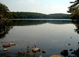
Sunfish Pond is a 44 acres (17.8 ha) glacial lake
surrounded by a 258 acres (104.4 ha) hardwood forest located on the Kittatinny Ridge within Worthington State Forest
, adjacent to the Delaware Water Gap National Recreation Area
in Warren County
, New Jersey
. The Appalachian Trail
runs alongside the western and northern edges of the pond. It was created by the Wisconsin Glacier during the last ice age. The pond was declared a National Natural Landmark
in January 1970.
who used the forest as a deer hunting preserve; the pond supplied water to his mansion.
In 1965, there was a plan to create a reservoir which would have covered the pond. Casey Kayes, a local custodian, led 655 people on a hike to protest the plan. Further hikes and letter campaigns caused the power companies that owned the land to donate it to the state in 1966. Supreme Court Justice William O. Douglas
mentioned the pond in his dissenting opinion in the Sierra Club v. Morton case.
.
, which runs alongside the western and northern edges of the pond. It is the southernmost glacial tarn
along that trail.
The shortest distance is 1.5 miles from the trailhead. The trails are steep and rocky in places. There is no swimming in the pond. There is a Leave No Trace
campground about 1/4 mile away, but proper food precautions must be followed since black bears are active in the area.
There is a collection of ad hoc primitive rock artworks (cairns) along the northwestern shore.
Glacial lake
A glacial lake is a lake with origins in a melted glacier. Near the end of the last glacial period, roughly 10,000 years ago, glaciers began to retreat. A retreating glacier often left behind large deposits of ice in hollows between drumlins or hills. As the ice age ended, these melted to create...
surrounded by a 258 acres (104.4 ha) hardwood forest located on the Kittatinny Ridge within Worthington State Forest
Worthington State Forest
The 6,421 acre Worthington State Forest runs more than seven miles along the Kittatinny Ridge in Columbia, in Warren County, on the New Jersey side of the Delaware River, just north of the Delaware Water Gap in the Delaware Water Gap National Recreation Area. The park offers hiking, camping and...
, adjacent to the Delaware Water Gap National Recreation Area
Delaware Water Gap National Recreation Area
Delaware Water Gap National Recreation Area, administered by the National Park Service, preserves almost of land along the Delaware River's New Jersey and Pennsylvania shores, stretching from the Delaware Water Gap northward almost to the New York state line...
in Warren County
Warren County, New Jersey
Warren County is a county located in the U.S. state of New Jersey. As of the 2010 Census, the population was 108,692. Its county seat is Belvidere...
, New Jersey
New Jersey
New Jersey is a state in the Northeastern and Middle Atlantic regions of the United States. , its population was 8,791,894. It is bordered on the north and east by the state of New York, on the southeast and south by the Atlantic Ocean, on the west by Pennsylvania and on the southwest by Delaware...
. The Appalachian Trail
Appalachian Trail
The Appalachian National Scenic Trail, generally known as the Appalachian Trail or simply the AT, is a marked hiking trail in the eastern United States extending between Springer Mountain in Georgia and Mount Katahdin in Maine. It is approximately long...
runs alongside the western and northern edges of the pond. It was created by the Wisconsin Glacier during the last ice age. The pond was declared a National Natural Landmark
National Natural Landmark
The National Natural Landmark program recognizes and encourages the conservation of outstanding examples of the natural history of the United States. It is the only natural areas program of national scope that identifies and recognizes the best examples of biological and geological features in...
in January 1970.
History
The land was purchased by Charles C. WorthingtonCharles Campbell Worthington
Charles Campbell Worthington was an American industrialist whose efforts were in part responsible for the foundation of the Professional Golfers Association...
who used the forest as a deer hunting preserve; the pond supplied water to his mansion.
In 1965, there was a plan to create a reservoir which would have covered the pond. Casey Kayes, a local custodian, led 655 people on a hike to protest the plan. Further hikes and letter campaigns caused the power companies that owned the land to donate it to the state in 1966. Supreme Court Justice William O. Douglas
William O. Douglas
William Orville Douglas was an Associate Justice of the United States Supreme Court. With a term lasting 36 years and 209 days, he is the longest-serving justice in the history of the Supreme Court...
mentioned the pond in his dissenting opinion in the Sierra Club v. Morton case.
Flora and fauna
The pond is surrounded by stands of mountain laurel, sheep laurel, and Cunila origanoides. Nearby are fields of Symphoricarpos orbiculatusSymphoricarpos orbiculatus
Symphoricarpos orbiculatus, commonly called coralberry, buckbrush or Indian currant is a woody species of flowering plant in the honeysuckle family.-Description:...
.
Visiting
It is a popular hiking destination. Several trails reach the pond, including the Appalachian TrailAppalachian Trail
The Appalachian National Scenic Trail, generally known as the Appalachian Trail or simply the AT, is a marked hiking trail in the eastern United States extending between Springer Mountain in Georgia and Mount Katahdin in Maine. It is approximately long...
, which runs alongside the western and northern edges of the pond. It is the southernmost glacial tarn
Tarn (lake)
A tarn is a mountain lake or pool, formed in a cirque excavated by a glacier. A moraine may form a natural dam below a tarn. A corrie may be called a cirque.The word is derived from the Old Norse word tjörn meaning pond...
along that trail.
The shortest distance is 1.5 miles from the trailhead. The trails are steep and rocky in places. There is no swimming in the pond. There is a Leave No Trace
Leave No Trace
Leave No Trace is both a set of principles, and an organization that promotes those principles. The principles are designed to assist outdoor enthusiasts with their decisions about how to reduce their impacts when they hike, camp, picnic, snowshoe, run, bike, hunt, paddle, ride horses, fish, ski or...
campground about 1/4 mile away, but proper food precautions must be followed since black bears are active in the area.
There is a collection of ad hoc primitive rock artworks (cairns) along the northwestern shore.