

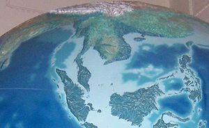
Sunda Shelf
Encyclopedia
Geology
Geology is the science comprising the study of solid Earth, the rocks of which it is composed, and the processes by which it evolves. Geology gives insight into the history of the Earth, as it provides the primary evidence for plate tectonics, the evolutionary history of life, and past climates...
, the Sunda Shelf is a south east extension of the continental shelf
Continental shelf
The continental shelf is the extended perimeter of each continent and associated coastal plain. Much of the shelf was exposed during glacial periods, but is now submerged under relatively shallow seas and gulfs, and was similarly submerged during other interglacial periods. The continental margin,...
of Southeast Asia
Southeast Asia
Southeast Asia, South-East Asia, South East Asia or Southeastern Asia is a subregion of Asia, consisting of the countries that are geographically south of China, east of India, west of New Guinea and north of Australia. The region lies on the intersection of geological plates, with heavy seismic...
. Major landmasses on the shelf include the Malay Peninsula
Malay Peninsula
The Malay Peninsula or Thai-Malay Peninsula is a peninsula in Southeast Asia. The land mass runs approximately north-south and, at its terminus, is the southern-most point of the Asian mainland...
, Sumatra
Sumatra
Sumatra is an island in western Indonesia, westernmost of the Sunda Islands. It is the largest island entirely in Indonesia , and the sixth largest island in the world at 473,481 km2 with a population of 50,365,538...
, Borneo
Borneo
Borneo is the third largest island in the world and is located north of Java Island, Indonesia, at the geographic centre of Maritime Southeast Asia....
, Java, Madura
Madura
Madura is an Indonesian island off the northeastern coast of Java. The island comprises an area of approximately 4,250 km². Madura is administered as part of the East Java province. It is separated from Java by the narrow Strait of Madura.-History:...
, Bali
Bali
Bali is an Indonesian island located in the westernmost end of the Lesser Sunda Islands, lying between Java to the west and Lombok to the east...
and their surrounding smaller islands. It covers an area of approximately 1.85 million km2. Sea depths over the shelf rarely exceed 50 metres and extensive areas are less than 20 metres resulting in strong bottom friction and strong tidal friction. Steep undersea gradients separate the Sunda Shelf from the Philippines
Philippines
The Philippines , officially known as the Republic of the Philippines , is a country in Southeast Asia in the western Pacific Ocean. To its north across the Luzon Strait lies Taiwan. West across the South China Sea sits Vietnam...
, Sulawesi
Sulawesi
Sulawesi is one of the four larger Sunda Islands of Indonesia and is situated between Borneo and the Maluku Islands. In Indonesia, only Sumatra, Borneo, and Papua are larger in territory, and only Java and Sumatra have larger Indonesian populations.- Etymology :The Portuguese were the first to...
and the Lesser Sunda Islands
Lesser Sunda Islands
The Lesser Sunda Islands or Nusa Tenggara are a group of islands in the southern Maritime Southeast Asia, north of Australia. Together with the Greater Sunda Islands to the west they make up the Sunda Islands...
.
Biogeographically
Biogeography
Biogeography is the study of the distribution of species , organisms, and ecosystems in space and through geological time. Organisms and biological communities vary in a highly regular fashion along geographic gradients of latitude, elevation, isolation and habitat area...
, Sundaland
Sundaland
Sundaland is a biogeographical region of Southeastern Asia which encompasses the areas of the Asian continental shelf that was exposed during the last ice age. It included the Malay Peninsula on the Asian mainland, as well as the large islands of Borneo, Java, and Sumatra and their surrounding...
is a term for the region of Southeastern Asia
Southeast Asia
Southeast Asia, South-East Asia, South East Asia or Southeastern Asia is a subregion of Asia, consisting of the countries that are geographically south of China, east of India, west of New Guinea and north of Australia. The region lies on the intersection of geological plates, with heavy seismic...
which encompasses these areas of the Asia
Asia
Asia is the world's largest and most populous continent, located primarily in the eastern and northern hemispheres. It covers 8.7% of the Earth's total surface area and with approximately 3.879 billion people, it hosts 60% of the world's current human population...
n continental shelf that were exposed during the last ice age. Sundaland included the Malay Peninsula
Malay Peninsula
The Malay Peninsula or Thai-Malay Peninsula is a peninsula in Southeast Asia. The land mass runs approximately north-south and, at its terminus, is the southern-most point of the Asian mainland...
on the Asian mainland, as well as the large islands of Borneo
Borneo
Borneo is the third largest island in the world and is located north of Java Island, Indonesia, at the geographic centre of Maritime Southeast Asia....
, Java, and Sumatra
Sumatra
Sumatra is an island in western Indonesia, westernmost of the Sunda Islands. It is the largest island entirely in Indonesia , and the sixth largest island in the world at 473,481 km2 with a population of 50,365,538...
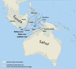
and their surrounding islands. The same steep undersea gradients that mark the eastern boundary of Sundaland are identified biogeographically by the Wallace Line
Wallace Line
The Wallace Line separates the ecozones of Asia and Wallacea, a transitional zone between Asia and Australia. West of the line are found organisms related to Asiatic species; to the east, a mixture of species of Asian and Australian origin is present...
, identified by Alfred Russel Wallace
Alfred Russel Wallace
Alfred Russel Wallace, OM, FRS was a British naturalist, explorer, geographer, anthropologist and biologist...
, which marks the eastern boundary of the Asia's land mammal
Mammal
Mammals are members of a class of air-breathing vertebrate animals characterised by the possession of endothermy, hair, three middle ear bones, and mammary glands functional in mothers with young...
fauna, and is the boundary of the Indomalaya
Indomalaya
The Indomalaya ecozone is one of the eight ecozones that cover the planet's land surface. It extends across most of South and Southeast Asia and into the southern parts of East Asia....
and Australasia ecozone
Australasia ecozone
The Australasian zone is an ecological region that is coincident, but not synonymous , with the geographic region of Australasia...
s.
The shelf has resulted from millennia of volcanic activity and erosion of the Asian continental mass, and the build up and consolidation of debris along the margins as sea levels rose and fell.
The seas between the islands cover relatively stable ancient pene-plains that are characterised by low seismicity, low isostatic gravity anomalies and no active volcanoes with the exception of Sumatra, Java, and Bali, which while connected to the Sunda Shelf, belong geologically to the young Sunda Arc
Sunda Arc
The Sunda Arc is a volcanic arc that has produced the islands of Sumatra and Java, the Sunda Strait and the Lesser Sunda Islands. A chain of volcanoes forms the topographic spine of these islands...
orogenic system (i.e., the Sunda Mountain System). During glacial period
Glacial period
A glacial period is an interval of time within an ice age that is marked by colder temperatures and glacier advances. Interglacials, on the other hand, are periods of warmer climate within an ice age...
s, the sea level
Sea level
Mean sea level is a measure of the average height of the ocean's surface ; used as a standard in reckoning land elevation...
falls, and great expanses of the Sunda Shelf are exposed as a marshy plain. The rise of sea level during a meltwater pulse 14.6 to 14.3 kbp was as much as 16 meters within 300 years.
Sundaland
Sundaland is a biogeographical region of Southeastern Asia which encompasses the areas of the Asian continental shelf that was exposed during the last ice age. It included the Malay Peninsula on the Asian mainland, as well as the large islands of Borneo, Java, and Sumatra and their surrounding...
during the last glacial maximum 18,000 to 20,000 years ago. Generally, the paleo-rivers are extensions of present-day river systems and may be interpreted to follow topographic lows in a down-slope direction. During the driest of the Pleistocene era the catchments forming west Borneo and the majority of Sumatra emptied through the Great Sunda River which arose between Belitung Island and Borneo flowing north east between the North and South Natuna
South Natuna
South Natuna is an archipelago off the west coast of the island of Borneo, the southernmost group of the Natuna Islands in the South China Sea. Geographically it is part of the Tudjuh Archipelago, and administratively part of the Riau Islands province of Indonesia. The archipelago is spread out...
Islands. North Java and south Borneo emptied in an easterly direction between southern Borneo and Java.
To the east of the Sunda Shelf is the Sahul Shelf
Sahul Shelf
The Sahul Shelf is part of the continental shelf of Sahul and lies off the coast of Australia. The Sahul Shelf proper stretches northwest from Australia much of the way under the Timor Sea towards Timor, ending where the seabed begins descending into the Timor Trough...
. Separating these two regions of shallow seas is Wallacea
Wallacea
Wallacea is a biogeographical designation for a group of Indonesian islands separated by deep water straits from the Asian and Australian continental shelves. Wallacea includes Sulawesi, the largest island in the group, as well as Lombok, Sumbawa, Flores, Sumba, Timor, Halmahera, Buru, Seram, and...
, which encompasses Sulawesi
Sulawesi
Sulawesi is one of the four larger Sunda Islands of Indonesia and is situated between Borneo and the Maluku Islands. In Indonesia, only Sumatra, Borneo, and Papua are larger in territory, and only Java and Sumatra have larger Indonesian populations.- Etymology :The Portuguese were the first to...
and the thousands of smaller islands making up Nusa Tenggara and Maluku
Maluku Islands
The Maluku Islands are an archipelago that is part of Indonesia, and part of the larger Maritime Southeast Asia region. Tectonically they are located on the Halmahera Plate within the Molucca Sea Collision Zone...
. Within Wallacea lie some of the deepest seas in the world with depths of up to 7,000 metres. Passing between Bali
Bali
Bali is an Indonesian island located in the westernmost end of the Lesser Sunda Islands, lying between Java to the west and Lombok to the east...
and Lombok
Lombok
Lombok is an island in West Nusa Tenggara province, Indonesia. It forms part of the chain of the Lesser Sunda Islands, with the Lombok Strait separating it from Bali to the west and the Alas Strait between it and Sumbawa to the east...
, and Borneo
Borneo
Borneo is the third largest island in the world and is located north of Java Island, Indonesia, at the geographic centre of Maritime Southeast Asia....
and Sulawesi, the Wallacea is marked by a transition zone of flora and fauna first described by Alfred Russel Wallace
Alfred Russel Wallace
Alfred Russel Wallace, OM, FRS was a British naturalist, explorer, geographer, anthropologist and biologist...
. The complicated history of island formation on the Sunda Shelf and changing landbridge connections with mainland Southeast Asia have resulted in a high degree of endemism and local distribution discontinuities, discussed at Sundaland
Sundaland
Sundaland is a biogeographical region of Southeastern Asia which encompasses the areas of the Asian continental shelf that was exposed during the last ice age. It included the Malay Peninsula on the Asian mainland, as well as the large islands of Borneo, Java, and Sumatra and their surrounding...
, the biogeographical province
Biogeography
Biogeography is the study of the distribution of species , organisms, and ecosystems in space and through geological time. Organisms and biological communities vary in a highly regular fashion along geographic gradients of latitude, elevation, isolation and habitat area...
that has resulted from these changes.
The exposure of the Sunda Shelf during eustatic sea level changes has effects on the El Niño oscillation.
W. Earle in 1845 was the first to describe the general features of the Sunda and Sahul Shelves, which he termed the "Great Asiatic Bank" and the "Great Australian Bank" respectively.
External links
- Voris, H., and C. Simpson, 2000 and 2006, Pleistocene Sea Level / Paleogeography Maps of Sunda Shelf The Field Museum, Chicago, Illinois.