

Submarine earthquake
Encyclopedia


Earthquake
An earthquake is the result of a sudden release of energy in the Earth's crust that creates seismic waves. The seismicity, seismism or seismic activity of an area refers to the frequency, type and size of earthquakes experienced over a period of time...
that occurs underwater
Underwater
Underwater is a term describing the realm below the surface of water where the water exists in a natural feature such as an ocean, sea, lake, pond, or river. Three quarters of the planet Earth is covered by water...
at the bottom
Seabed
The seabed is the bottom of the ocean.- Ocean structure :Most of the oceans have a common structure, created by common physical phenomena, mainly from tectonic movement, and sediment from various sources...
of a body of water
Body of water
A body of water or waterbody is any significant accumulation of water, usually covering the Earth or another planet. The term body of water most often refers to large accumulations of water, such as oceans, seas, and lakes, but it may also include smaller pools of water such as ponds, puddles or...
, especially an ocean
Ocean
An ocean is a major body of saline water, and a principal component of the hydrosphere. Approximately 71% of the Earth's surface is covered by ocean, a continuous body of water that is customarily divided into several principal oceans and smaller seas.More than half of this area is over 3,000...
. They are the leading cause of tsunami
Tsunami
A tsunami is a series of water waves caused by the displacement of a large volume of a body of water, typically an ocean or a large lake...
s. The magnitude can be measured scientifically by the use of either the Richter scale or the Mercalli scale.
Understanding plate tectonics
Plate tectonics
Plate tectonics is a scientific theory that describes the large scale motions of Earth's lithosphere...
helps to explain the cause of submarine earthquakes. The Earth's surface or lithosphere
Lithosphere
The lithosphere is the rigid outermost shell of a rocky planet. On Earth, it comprises the crust and the portion of the upper mantle that behaves elastically on time scales of thousands of years or greater.- Earth's lithosphere :...
comprises tectonic plates
Tectonic Plates
Tectonic Plates is a 1992 independent Canadian film directed by Peter Mettler. Mettler also wrote the screenplay based on the play by Robert Lepage. The film stars Marie Gignac, Céline Bonnier and Robert Lepage.-Plot summary:...
which average approximately 50 miles in thickness, and are continuously moving very slowly upon a bed of magma in the asthenosphere
Asthenosphere
The asthenosphere is the highly viscous, mechanically weak and ductilely-deforming region of the upper mantle of the Earth...
and inner mantle
Mantle (geology)
The mantle is a part of a terrestrial planet or other rocky body large enough to have differentiation by density. The interior of the Earth, similar to the other terrestrial planets, is chemically divided into layers. The mantle is a highly viscous layer between the crust and the outer core....
. The plates converge upon one another, and one subducts below the other, or, where there is only shear stress, move horizontally past each other (see transform plate boundary below). Little movements called fault creep are minor and not measurable. The plates meet with each other, and if rough spots cause the movement to stop at the edges, the motion of the plates continue. When the rough spots can no longer hold, the sudden release of the built-up motion releases, and the sudden movement under the sea floor causes a submarine earthquake. This area of slippage both horizontally and vertically is called the epicenter
Epicenter
The epicenter or epicentre is the point on the Earth's surface that is directly above the hypocenter or focus, the point where an earthquake or underground explosion originates...
, and has the highest magnitude, and causes the greatest damage.
As with a continental
Continent
A continent is one of several very large landmasses on Earth. They are generally identified by convention rather than any strict criteria, with seven regions commonly regarded as continents—they are : Asia, Africa, North America, South America, Antarctica, Europe, and Australia.Plate tectonics is...
earthquake the severity of the damage is not often caused by the earthquake at the rift zone, but rather by events which are triggered by the earthquake. Where a continental earthquake will cause damage and loss of life on land from fires, damaged structures, and flying objects; a submarine earthquake alters the sea bed floor, resulting in a series of waves, and depending on the length and magnitude of the earthquake, huge tidal waves and tsunamis, which bear down on coastal cities causing property damages and loss of life.
Submarine earthquakes can also damage submarine communications cable
Submarine communications cable
A submarine communications cable is a cable laid on the sea bed between land-based stations to carry telecommunication signals across stretches of ocean....
s, leading to widespread disruption of the Internet
Internet
The Internet is a global system of interconnected computer networks that use the standard Internet protocol suite to serve billions of users worldwide...
and international telephone network in those areas. This is particularly common in Asia, where many submarine links cross submarine earthquake zones such as the Pacific Ring of Fire
Pacific Ring of Fire
The Pacific Ring of Fire is an area where large numbers of earthquakes and volcanic eruptions occur in the basin of the Pacific Ocean. In a horseshoe shape, it is associated with a nearly continuous series of oceanic trenches, volcanic arcs, and volcanic belts and/or plate movements...
.
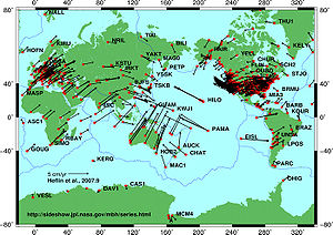
Tectonic plate boundaries
The different ways in which tectonic plates rub against each other under the ocean or sea floor to create submarine earthquakes. The type of friction created may be due to the characteristic of the geologic fault or the plate boundary as follows. Some of the main areas of large tsunami producing submarine earthquakes are the Pacific Ring of FirePacific Ring of Fire
The Pacific Ring of Fire is an area where large numbers of earthquakes and volcanic eruptions occur in the basin of the Pacific Ocean. In a horseshoe shape, it is associated with a nearly continuous series of oceanic trenches, volcanic arcs, and volcanic belts and/or plate movements...
and the Great Sumatran fault
Great Sumatran fault
The Indonesian island of Sumatra is located in a highly seismic area of the world. In addition to the subduction zone and the associated Sunda Arc off the west coast of the island, Sumatra also has a large strike-slip fault, the so-called Great Sumatran Fault, running the entire length of the island...
.
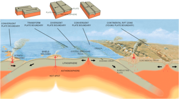
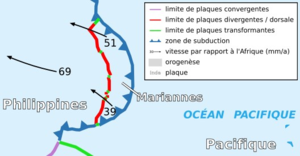
Convergent plate boundary
The older, and denser plate moves below the lighter plate. The further down it moves, the hotter it becomes, until finally melting altogether at the asthenosphereAsthenosphere
The asthenosphere is the highly viscous, mechanically weak and ductilely-deforming region of the upper mantle of the Earth...
and inner mantle and the crust is actually destroyed. The location where the two oceanic plates actually meet
Convergent boundary
In plate tectonics, a convergent boundary, also known as a destructive plate boundary , is an actively deforming region where two tectonic plates or fragments of lithosphere move toward one another and collide...
become deeper and deeper creating trenches with each successive action. There is an interplay of various densities of lithosphere rock, asthenosphere magma, cooling ocean water and plate movement for example the Pacific Ring of Fire
Pacific Ring of Fire
The Pacific Ring of Fire is an area where large numbers of earthquakes and volcanic eruptions occur in the basin of the Pacific Ocean. In a horseshoe shape, it is associated with a nearly continuous series of oceanic trenches, volcanic arcs, and volcanic belts and/or plate movements...
. Therefore the site of the sub oceanic trench
Oceanic trench
The oceanic trenches are hemispheric-scale long but narrow topographic depressions of the sea floor. They are also the deepest parts of the ocean floor....
will be a site of submarine earthquakes; for example the Mariana Trench
Mariana Trench
The Mariana Trench or Marianas Trench is the deepest part of the world's oceans. It is located in the western Pacific Ocean, to the east of the Mariana Islands. The trench is about long but has a mean width of only...
, Puerto Rico Trench
Puerto Rico Trench
The Puerto Rico Trench is an oceanic trench located on the boundary between the Caribbean Sea and the Atlantic Ocean. The trench is associated with a complex transition between the subduction zone to the south along the Lesser Antilles island arc and the major transform fault zone or plate boundary...
, and the volcanic arc
Volcanic arc
A volcanic arc is a chain of volcanoes positioned in an arc shape as seen from above. Offshore volcanoes form islands, resulting in a volcanic island arc. Generally they result from the subduction of an oceanic tectonic plate under another tectonic plate, and often parallel an oceanic trench...
along the Great Sumatran fault
Great Sumatran fault
The Indonesian island of Sumatra is located in a highly seismic area of the world. In addition to the subduction zone and the associated Sunda Arc off the west coast of the island, Sumatra also has a large strike-slip fault, the so-called Great Sumatran Fault, running the entire length of the island...
.
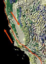
Transform plate boundary
A transform-fault boundary, or simply a transform boundary is where two plates will slide past each other, and the irregular pattern of their edges may catch on each other. The lithosphere is neither added to from the asthenosphere nor is it destroyed as in convergent plate action. For example along the San Andreas faultSan Andreas Fault
The San Andreas Fault is a continental strike-slip fault that runs a length of roughly through California in the United States. The fault's motion is right-lateral strike-slip...
strike-slip fault zone, the Pacific Tectonic Plate has been moving along at about 5 cm/yr in a northwesterly direction, whereas the North American Plate is moving south-easterly.
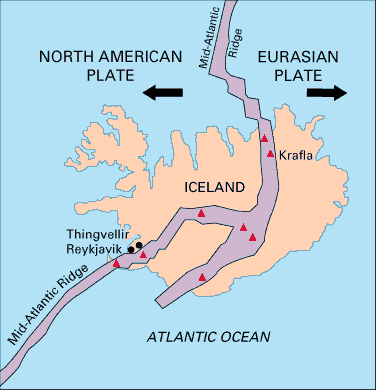
Divergent plate boundary
Rising convection currents occur where two plates are moving away from each other. In the gapSeafloor spreading
Seafloor spreading is a process that occurs at mid-ocean ridges, where new oceanic crust is formed through volcanic activity and then gradually moves away from the ridge. Seafloor spreading helps explain continental drift in the theory of plate tectonics....
, thus produced hot magma rises up, meets the cooler sea water, cools, and solidifies, attaching to either or both tectonic plate edges creating an oceanic spreading ridge. When the fissure again appears, again magma will rise up, and form new lithosphere crust. If the weakness between the two plates allows the heat and pressure of the asthenosphere to build over a large amount of time, a large quantity of magma will be released pusing up on the plate edges and the magma will solidify under the newly raised plate edges, see formation of a submarine volcano
Submarine volcano
Submarine volcanoes are underwater fissures in the Earth's surface from which magma can erupt. They are estimated to account for 75% of annual magma output. The vast majority are located near areas of tectonic plate movement, known as ocean ridges...
. If the fissure is able to come apart because of the two plates moving apart, in a sudden movement, an earthquake tremor may be felt for example at the Mid-Atlantic Ridge
Mid-Atlantic Ridge
The Mid-Atlantic Ridge is a mid-ocean ridge, a divergent tectonic plate boundary located along the floor of the Atlantic Ocean, and part of the longest mountain range in the world. It separates the Eurasian Plate and North American Plate in the North Atlantic, and the African Plate from the South...
between North America
North America
North America is a continent wholly within the Northern Hemisphere and almost wholly within the Western Hemisphere. It is also considered a northern subcontinent of the Americas...
and Africa
Africa
Africa is the world's second largest and second most populous continent, after Asia. At about 30.2 million km² including adjacent islands, it covers 6% of the Earth's total surface area and 20.4% of the total land area...
.
List of major submarine earthquakes
The following is a list of major submarine earthquakes.| Date | Event | Location | Estimated Moment Magnitude ( ) ) |
Other Details/Notes |
|---|---|---|---|---|
| March 11, 2011 | 2011 Tōhoku earthquake | The epicenter is 130 kilometers (81 mi) off the east coast of the Oshika Peninsula, Tōhoku, with the hypocenter at a depth of 32 km (20 mi). | 9.0 | This is strongest known earthquake to hit Japan |
| December 26, 2006 | 2006 Hengchun earthquake 2006 Hengchun earthquake The 2006 Hengchun earthquake occurred on Tuesday December 26, 2006 at 12:25 UTC , with an epicenter off the southwest coast of Taiwan, approximately 22.8 km west southwest of Hengchun, Pingtung County, Taiwan, with an exact hypocenter 21.9 km deep in the Luzon Strait , which connects the... |
The epicenter is off the southwest coast of Taiwan Taiwan Taiwan , also known, especially in the past, as Formosa , is the largest island of the same-named island group of East Asia in the western Pacific Ocean and located off the southeastern coast of mainland China. The island forms over 99% of the current territory of the Republic of China following... , in the Luzon Strait Luzon Strait The Luzon Strait is the strait between the island country of Taiwan and Luzon island of the Philippines. The strait thereby connects the Philippine Sea to the South China Sea in the western Pacific Ocean.... , which connects the South China Sea South China Sea The South China Sea is a marginal sea that is part of the Pacific Ocean, encompassing an area from the Singapore and Malacca Straits to the Strait of Taiwan of around... with the Philippine Sea Philippine Sea The Philippine Sea is a marginal sea east and north of the Philippines occupying an estimated surface area of 2 million mi² on the western part of the North Pacific Ocean... . |
7.1 | |
| December 26, 2004 | 2004 Indian Ocean earthquake 2004 Indian Ocean earthquake The 2004 Indian Ocean earthquake was an undersea megathrust earthquake that occurred at 00:58:53 UTC on Sunday, December 26, 2004, with an epicentre off the west coast of Sumatra, Indonesia. The quake itself is known by the scientific community as the Sumatra-Andaman earthquake... |
The epicenter is off the northwestern coast of Sumatra Sumatra Sumatra is an island in western Indonesia, westernmost of the Sunda Islands. It is the largest island entirely in Indonesia , and the sixth largest island in the world at 473,481 km2 with a population of 50,365,538... , Indonesia Indonesia Indonesia , officially the Republic of Indonesia , is a country in Southeast Asia and Oceania. Indonesia is an archipelago comprising approximately 13,000 islands. It has 33 provinces with over 238 million people, and is the world's fourth most populous country. Indonesia is a republic, with an... . |
9.3 | This is the third largest earthquake in recorded history Recorded history Recorded history is the period in history of the world after prehistory. It has been written down using language, or recorded using other means of communication. It starts around the 4th millennium BC, with the invention of writing.-Historical accounts:... and generated massive tsunamis, which caused widespread devastation when they hit land, leaving an estimated 230,000 people dead in countries around the Bay of Bengal Bay of Bengal The Bay of Bengal , the largest bay in the world, forms the northeastern part of the Indian Ocean. It resembles a triangle in shape, and is bordered mostly by the Eastern Coast of India, southern coast of Bangladesh and Sri Lanka to the west and Burma and the Andaman and Nicobar Islands to the... and the Indian Ocean Indian Ocean The Indian Ocean is the third largest of the world's oceanic divisions, covering approximately 20% of the water on the Earth's surface. It is bounded on the north by the Indian Subcontinent and Arabian Peninsula ; on the west by eastern Africa; on the east by Indochina, the Sunda Islands, and... . |
| May 4, 1998 | A part of the island of Yonaguni Yonaguni is one of the Yaeyama Islands. It is the westernmost inhabited island of Japan and lies from the east coast of Taiwan, between the East China Sea and the Pacific Ocean proper.... was destroyed by a submarine earthquake Earthquake An earthquake is the result of a sudden release of energy in the Earth's crust that creates seismic waves. The seismicity, seismism or seismic activity of an area refers to the frequency, type and size of earthquakes experienced over a period of time... . |
|||
| May 22, 1960 | 1960 Valdivia earthquake (Great Chilean Earthquake) | The epicenter is off the coast of South Central Chile Chile Chile ,officially the Republic of Chile , is a country in South America occupying a long, narrow coastal strip between the Andes mountains to the east and the Pacific Ocean to the west. It borders Peru to the north, Bolivia to the northeast, Argentina to the east, and the Drake Passage in the far... . |
9.5 | This is the strongest earthquake ever recorded. |
| December 20, 1946 | 1946 Nankaido earthquake 1946 Nankaido earthquake The 1946 Nankaidō earthquake was a great earthquake in Nankaidō, Japan. It occurred on December 20, 1946 at 19:19 UTC. The earthquake measured between 8.1 and 8.4 on the moment magnitude scale, and was felt from Northern Honshū to Kyūshū... |
The epicenter is off the southern coast of Kii Peninsula Kii Peninsula The is the largest peninsula on the island of Honshū in Japan. The area south of the “Central Tectonic Line” is called Nankii , and includes the most poleward living coral reefs in the world due to the presence of the warm Kuroshio Current, though these are threatened by global warming and human... and Shikoku Shikoku is the smallest and least populous of the four main islands of Japan, located south of Honshū and east of the island of Kyūshū. Its ancient names include Iyo-no-futana-shima , Iyo-shima , and Futana-shima... , Japan Japan Japan is an island nation in East Asia. Located in the Pacific Ocean, it lies to the east of the Sea of Japan, China, North Korea, South Korea and Russia, stretching from the Sea of Okhotsk in the north to the East China Sea and Taiwan in the south... . |
8.1 | |
| December 7, 1944 | 1944 Tōnankai earthquake 1944 Tōnankai earthquake The 1944 Tōnankai earthquake occurred at 13:35 local time on 7 December. It had an estimated magnitude of 8.1 on the moment magnitude scale and a maximum felt intensity of greater than 5 shindo . It triggered a large tsunami that caused serious damage along the coast of Wakayama Prefecture and the... |
The epicenter is about 20 km off the coast of the Shima Peninsula in Japan. | 8.0 | |
| November 18, 1929 | 1929 Grand Banks earthquake 1929 Grand Banks earthquake The 1929 Grand Banks earthquake, also called the Laurentian Slope earthquake and the South Shore Disaster, was a magnitude 7.2 earthquake that occurred on November 18, 1929 in the Atlantic Ocean off the south coast of Newfoundland in the Laurentian Slope Seismic Zone.The earthquake was centred on... |
The epicenter is at Grand Banks Grand Banks The Grand Banks of Newfoundland are a group of underwater plateaus southeast of Newfoundland on the North American continental shelf. These areas are relatively shallow, ranging from in depth. The cold Labrador Current mixes with the warm waters of the Gulf Stream here.The mixing of these waters... , off the south coast of Newfoundland Dominion of Newfoundland The Dominion of Newfoundland was a British Dominion from 1907 to 1949 . The Dominion of Newfoundland was situated in northeastern North America along the Atlantic coast and comprised the island of Newfoundland and Labrador on the continental mainland... in the Atlantic Ocean Atlantic Ocean The Atlantic Ocean is the second-largest of the world's oceanic divisions. With a total area of about , it covers approximately 20% of the Earth's surface and about 26% of its water surface area... . |
7.2 | |
| June 15, 1896 | 1896 Meiji-Sanriku earthquake 1896 Meiji-Sanriku earthquake The 1896 Meiji-Sanriku earthquake was highly destructive, generating one of the most devastating tsunamis in Japanese history, destroying about 9,000 homes and causing at least 22,000 deaths. This magnitude 7.2 event occurred at 19:32 on June 15, 1896... |
The epicenter is off the Sanriku coast Sanriku Coast The is a coastal region on the Pacific Ocean, extending from southern Aomori prefecture, through Iwate prefecture and northern Miyagi prefecture in northeastern Honshū, which is Japan's main island... of northeastern Honshū Honshu is the largest island of Japan. The nation's main island, it is south of Hokkaido across the Tsugaru Strait, north of Shikoku across the Inland Sea, and northeast of Kyushu across the Kanmon Strait... , Japan. |
8.5 | |
| April 4, 1771 | The epicenter is near Yaeyama Islands Yaeyama Islands The Yaeyama Islands are a group of islands in Okinawa Prefecture, Japan.The isles are the remotest part of Japan from the main islands and contains Japan's most southern and most western inhabited islands.The islands form the southern part of the volcanic Nansei Islands... in Okinawa, Japan. |
7.4 | ||
| January 26, 1700 | 1700 Cascadia earthquake | The epicenter is offshore from Vancouver Island Vancouver Island Vancouver Island is a large island in British Columbia, Canada. It is one of several North American locations named after George Vancouver, the British Royal Navy officer who explored the Pacific Northwest coast of North America between 1791 and 1794... to northern California California California is a state located on the West Coast of the United States. It is by far the most populous U.S. state, and the third-largest by land area... . |
~9.0 | This is one of the largest earthquakes on record. |
See also
- 2004 Indian Ocean earthquake characteristics
- List of plate tectonics topics
- Cascadia subduction zoneCascadia subduction zoneThe Cascadia subduction zone is a subduction zone, a type of convergent plate boundary that stretches from northern Vancouver Island to northern California. It is a very long sloping fault that separates the Juan de Fuca and North America plates.New ocean floor is being created offshore of...
- Fracture zoneFracture zoneA fracture zone is a linear oceanic feature--often hundreds, even thousands of kilometers long--resulting from the action of offset mid-ocean ridge axis segments. They are a consequence of plate tectonics. Lithospheric plates on either side of an active transform fault move in opposite directions;...
- GeologyGeologyGeology is the science comprising the study of solid Earth, the rocks of which it is composed, and the processes by which it evolves. Geology gives insight into the history of the Earth, as it provides the primary evidence for plate tectonics, the evolutionary history of life, and past climates...
- Sedimentary basinSedimentary basinThe term sedimentary basin is used to refer to any geographical feature exhibiting subsidence and consequent infilling by sedimentation. As the sediments are buried, they are subjected to increasing pressure and begin the process of lithification...
- List of tectonic plates
- List of tectonic plate interactions
- MetamorphismMetamorphismMetamorphism is the solid-state recrystallization of pre-existing rocks due to changes in physical and chemical conditions, primarily heat, pressure, and the introduction of chemically active fluids. Mineralogical, chemical and crystallographic changes can occur during this process...
- Plate TectonicsPlate tectonicsPlate tectonics is a scientific theory that describes the large scale motions of Earth's lithosphere...
- Triple junctionTriple junctionA triple junction is the point where the boundaries of three tectonic plates meet. At the triple junction a boundary will be one of 3 types - a ridge, trench or transform fault - and triple junctions can be described according to the types of plate margin that meet at them...
- TsunamiTsunamiA tsunami is a series of water waves caused by the displacement of a large volume of a body of water, typically an ocean or a large lake...