

Subglacial eruption
Encyclopedia
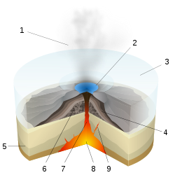
A subglacial eruption is a volcanic eruption that has occurred under ice, or under a glacier
Glacier
A glacier is a large persistent body of ice that forms where the accumulation of snow exceeds its ablation over many years, often centuries. At least 0.1 km² in area and 50 m thick, but often much larger, a glacier slowly deforms and flows due to stresses induced by its weight...
. Subglacial eruptions can cause dangerous floods, lahars and create hyaloclastite
Hyaloclastite
Hyaloclastite is a hydrated tuff-like breccia rich in black volcanic glass, formed during volcanic eruptions under water, under ice or where subaerial flows reach the sea or other bodies of water. It has the appearance of angular flat fragments sized between a millimeter to few centimeters...
and pillow lava
Pillow lava
Pillow lavas are lavas that contain characteristic pillow-shaped structures that are attributed to the extrusion of the lava under water, or subaqueous extrusion. Pillow lavas in volcanic rock are characterized by thick sequences of discontinuous pillow-shaped masses, commonly up to one metre in...
. Subglacial eruptions sometimes form a subglacial volcano called a tuya
Tuya
A tuya is a type of distinctive, flat-topped, steep-sided volcano formed when lava erupts through a thick glacier or ice sheet. They are somewhat rare worldwide, being confined to regions which were covered by glaciers and also had active volcanism during the same time period.-Formation:Tuyas are...
. Tuyas in Iceland
Iceland
Iceland , described as the Republic of Iceland, is a Nordic and European island country in the North Atlantic Ocean, on the Mid-Atlantic Ridge. Iceland also refers to the main island of the country, which contains almost all the population and almost all the land area. The country has a population...
are called table mountain
Table Mountain (disambiguation)
A table mountain is a large table or mesa hence the name of numerous mountains around the world:Mountains:*Table Mountain is a large flat-topped mountain overlooking Cape Town, South Africa....
s because of their flat tops. Tuya Butte
Tuya Butte
Tuya Butte is a tuya in the Tuya Range of north-central British Columbia, Canada. It is a bit less isolated from other ranges than neighbouring Mount Josephine...
, in northern British Columbia
British Columbia
British Columbia is the westernmost of Canada's provinces and is known for its natural beauty, as reflected in its Latin motto, Splendor sine occasu . Its name was chosen by Queen Victoria in 1858...
is an example of a tuya. A tuya may be recognized by its stratigraphy
Stratigraphy
Stratigraphy, a branch of geology, studies rock layers and layering . It is primarily used in the study of sedimentary and layered volcanic rocks....
, which typically consists of a basal layer of pillow basalts overlain by hyaloclastite
Hyaloclastite
Hyaloclastite is a hydrated tuff-like breccia rich in black volcanic glass, formed during volcanic eruptions under water, under ice or where subaerial flows reach the sea or other bodies of water. It has the appearance of angular flat fragments sized between a millimeter to few centimeters...
breccia, tuff, and capped off by a lava flow. The pillow lavas formed first as a result of subaqueous eruptions in glacial meltwater. Once the vent reaches shallower water, eruptions become phreatomagmatic, depositing the hyaloclastite breccia. Once the volcano emerges through the ice, it erupts lava, forming the flat capping layer of a tuya.
The thermodynamics of subglacial eruptions are very poorly understood. Rare published studies indicate that plenty of heat is contained in the erupted lava, with 1 unit-volume of magma sufficient to melt about 10 units of ice. However, the rapidity by which ice is melted is unexplained, and in real eruptions the rate is at least an order of magnitude faster than existing predictions.
Antarctica eruption
On January, 2008, the British Antarctic SurveyBritish Antarctic Survey
The British Antarctic Survey is the United Kingdom's national Antarctic operation and has an active role in Antarctic affairs. BAS is part of the Natural Environment Research Council and has over 400 staff. It operates five research stations, two ships and five aircraft in and around Antarctica....
(Bas) scientists led by Hugh Corr and David Vaughan, reported (in the journal Nature Geoscience
Nature Geoscience
Nature Geoscience is a monthly, peer reviewed, scientific journal published by Nature Publishing Group. The Chief Editor is Heike Langenberg. The first issue was published in January 2008.-Scope:...
) that 2,200 years ago, a volcano
Volcano
2. Bedrock3. Conduit 4. Base5. Sill6. Dike7. Layers of ash emitted by the volcano8. Flank| 9. Layers of lava emitted by the volcano10. Throat11. Parasitic cone12. Lava flow13. Vent14. Crater15...
erupted under the Antarctica ice sheet (based on airborne survey
Aerial survey
Aerial survey is a geomatics method of collecting information by using aerial photography, LiDAR or from remote sensing imagery using other bands of the electromagnetic spectrum, such as infrared, gamma, or ultraviolet. It can also refer to the chart or map made by analysing a region from the air...
with radar images). The biggest eruption in the last 10,000 years, the volcanic ash was found deposited on the ice surface under the Hudson Mountains
Hudson Mountains
The Hudson Mountains is a group of parasitic cones forming nunataks just above the Antarctic ice sheet in west Ellsworth Land. They lie just east of Cranton Bay and Pine Island Bay at the eastern extremity of Amundsen Sea, and are bounded on the north by Cosgrove Ice Shelf and on the south by Pine...
, close to Pine Island Glacier
Pine Island Glacier
- Ice sheet drainage :The Antarctic ice sheet is the largest mass of ice on earth, containing a volume of water equivalent to of global sea level. The ice sheet forms from snow which falls onto the continent and compacts under its own weight. The ice then moves under its own weight toward the...
. The ash covered an area the size of New Hampshire
New Hampshire
New Hampshire is a state in the New England region of the northeastern United States of America. The state was named after the southern English county of Hampshire. It is bordered by Massachusetts to the south, Vermont to the west, Maine and the Atlantic Ocean to the east, and the Canadian...
(23,000 square kilometres) and was probably deposited from a 12 km high ash plume. Researchers have detected a mountainous peak some 100 meters beneath the surface believed to be the top of the tuya
Tuya
A tuya is a type of distinctive, flat-topped, steep-sided volcano formed when lava erupts through a thick glacier or ice sheet. They are somewhat rare worldwide, being confined to regions which were covered by glaciers and also had active volcanism during the same time period.-Formation:Tuyas are...
associated with this eruption.
Iceland
- BárðarbungaBárðarbungaBárðarbunga is an Icelandic stratovolcano located under the ice cap of Vatnajökull glacier, rising to 2,009 m above sea level, making it the second highest mountain in Iceland, just about 101 m lower than Hvannadalshnjúkur....
- EyjafjallajökullEyjafjallajökullEyjafjallajökull is one of the smaller ice caps of Iceland, situated to the north of Skógar and to the west of Mýrdalsjökull. The ice cap covers the caldera of a volcano with a summit elevation of . The volcano has erupted relatively frequently since the last glacial period, most recently in...
- GrímsvötnGrímsvötnThe Grímsvötn sub-glacial lakes and the volcano of the same name are in South-East Iceland. They are in the highlands of Iceland at the northwestern side of the Vatnajökull ice-cap. The lakes are at , at an elevation of...
- Hveravellir
- Katla
- KverkfjöllKverkfjöllThe mountain range Kverkfjöll is situated on the north-eastern border of the glacier Vatnajökull in Iceland. With their glacier Kverkjökull, they are to be found between the Vatnajökull and the Dyngjufjöll . The mountains are still active volcanoes...
- PrestahnúkurPrestahnúkurThe volcano Prestahnúkur is situated in the west of the Highlands of Iceland to the west of Langjökull glacier, or to be more specific, to the west of Geitlandsjökull glacier, a part of the Langjökull.-The volcanic system:...
- SnæfellsjökullSnæfellsjökullSnæfellsjökull is a 700,000 year old stratovolcano with a glacier covering its summit in western Iceland. The name of the mountain is actually Snæfell, but it is normally called "Snæfellsjökull" to distinguish it from two other mountains with this name...
- TorfajökullTorfajökullTorfajökull is a rhyolitic stratovolcano and complex of subglacial volcanoes, located north of Mýrdalsjökull and south of Þórisvatn Lake, Iceland...
- ÖræfajökullÖræfajökullÖræfajökull is an ice-covered volcano in south-east Iceland. It is the largest active volcano in the country, and on its north-western rim is Hvannadalshnúkur, the highest peak in Iceland...