
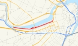
Storrow Drive
Encyclopedia
Charles River
The Charles River is an long river that flows in an overall northeasterly direction in eastern Massachusetts, USA. From its source in Hopkinton, the river travels through 22 cities and towns until reaching the Atlantic Ocean at Boston...
. It is a parkway
Parkway
The term parkway has several distinct principal meanings and numerous synonyms around the world, for either a type of landscaped area or a type of road.Type of landscaped area:...
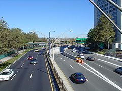
—it is restricted to cars; trucks and buses are not permitted on it. The road legally known as James Jackson Storrow Memorial Drive officially ends at its eastward junction with Route 28
Route 28 (Massachusetts)
Route 28 is a nominally south–north route in the U.S. state of Massachusetts, running from the town of Orleans via Boston to the New Hampshire state line in Methuen. Following the route from its nominally southern end, Route 28 initially heads south to the town of Chatham then turns west to...
and continues as Embankment Road, part of Route 28.
Boston drivers use the route for quick access to downtown locations. Westbound Storrow Drive has a junction with the Harvard Bridge
Harvard Bridge
The Harvard Bridge carries Massachusetts Avenue from Back Bay, Boston to Cambridge, Massachusetts. It is the longest bridge over the Charles River....
(Route 2A
Route 2A (Massachusetts)
Route 2A exists in several sections of Massachusetts, mainly as parts of former Route 2 that have been moved or upgraded. Route 2A runs from Greenfield in the west to Boston in the east...
, or Mass. Ave
Massachusetts Avenue (Boston)
Massachusetts Avenue, known to locals as Mass Ave, is a major thoroughfare in Boston, Massachusetts, and several cities and towns northwest of Boston...
). It passes along the northern edge of Boston University
Boston University
Boston University is a private research university located in Boston, Massachusetts. With more than 4,000 faculty members and more than 31,000 students, Boston University is one of the largest private universities in the United States and one of Boston's largest employers...
until it reaches a partial junction with the Boston University Bridge
Boston University Bridge
The Boston University Bridge , and commonly referred to as the BU Bridge, is a steel truss bridge with a suspended deck carrying Route 2 over the Charles River, connecting Boston to Cambridge, Massachusetts. According to the American Association of State Highway and Transportation Officials route...
(Route 2
Route 2 (Massachusetts)
Route 2 is a major east–west state highway in Massachusetts, parts of which are sometimes known as the Cambridge and Concord Turnpike. Along with Route 9 and U.S. Route 20 to the south, these highways are the main alternatives to the Massachusetts Turnpike/I-90 toll highway...
), where it becomes Soldiers Field Road
Soldiers Field Road
Soldiers Field Road is a major crosstown parkway in Boston, Massachusetts, running west to east from U.S. Route 20 in the neighborhood of Brighton to the Boston University Bridge...
.
Both Storrow Drive and Soldiers Field Road are maintained by the Massachusetts Department of Conservation and Recreation and are part of the parkway system interconnecting the Emerald Necklace
Emerald Necklace
The Emerald Necklace consists of an chain of parks linked by parkways and waterways in Boston and Brookline, Massachusetts. It gets its name from the way the planned chain appears to hang from the "neck" of the Boston peninsula, although it was never fully constructed.-Overview:The Necklace...
in Boston and Brookline
Brookline, Massachusetts
Brookline is a town in Norfolk County, Massachusetts, United States, which borders on the cities of Boston and Newton. As of the 2010 census, the population of the town was 58,732.-Etymology:...
. Together with Memorial Drive
Memorial Drive (Cambridge)
Memorial Drive runs along the north bank of the Charles River in Cambridge, Massachusetts. It is designated as U.S. Route 3 or Massachusetts Route 3 for its entire length, and Massachusetts Route 2 over the portion west of the Boston University Bridge....
and the Cambridge Parkway, Storrow Drive is also part of the Charles River Basin Historic District (listed in the National Register of Historic Places
National Register of Historic Places
The National Register of Historic Places is the United States government's official list of districts, sites, buildings, structures, and objects deemed worthy of preservation...
). Prior to 1989, Storrow Drive also carried the U.S. Route 1
U.S. Route 1
U.S. Route 1 is a major north–south U.S. Highway that serves the East Coast of the United States. It runs 2,377 miles from Fort Kent, Maine at the Canadian border south to Key West, Florida. U.S. 1 generally parallels Interstate 95, though it is significantly farther west between...
designation. (U.S. Route 1 is now routed along Interstate 93
Interstate 93
Interstate 93 is an Interstate Highway in the New England section of the United States. Its southern terminus is in Canton, Massachusetts, in the Boston metropolitan area, at Interstate 95; its northern terminus is near St. Johnsbury, Vermont, at Interstate 91...
).
Namesake
The parkway is named for James J. Storrow, an investment banker who led a campaign to create the Charles River Basin and preserve and improve the riverbanks as a public park. He had never advocated a parkway beside the river, and his widow publicly opposed it.Traffic issues
Concert parking
During some summer night concerts at the Hatch ShellHatch Shell
The Edward A. Hatch Memorial Shell is an outdoor concert venue adjacent to the Charles River Esplanade near downtown Boston....
, many drivers park their cars in the outbound lanes of Storrow Drive. The free concerts and fireworks displays attract 200,000 people, and many take advantage of the free parking.
Low clearance
A newcomer to Boston might be surprised at an abundance of signs giving road clearance height. Periodically, despite the signs, a truck or other large vehicle will get wedged under a bridge, which causes traffic to back up for several miles. In one incident a truck full of scissors became stuck and spilled its cargo, causing over 30 cars to get flat tires—two got four flat tires—and the road was backed up well into the afternoon.History
Between 1958 and 1971, Storrow Drive was designated Massachusetts Route C9.Early opposition
James Storrow had been instrumental in earlier projects along the Charles River, in particular the Charles River Dam. Additions to the EsplanadeEsplanade
An esplanade is a long, open, level area, usually next to a river or large body of water, where people may walk. The original meaning of esplanade was a large, open, level area outside fortress or city walls to provide clear fields of fire for the fortress' guns...
had been made during the 1930s only by omitting an important part of the project, a proposed highway from the Longfellow Bridge
Longfellow Bridge
The Longfellow Bridge, also known to locals as the "Salt-and-Pepper Bridge" or the "Salt-and-Pepper-Shaker Bridge" due to the shape of its central towers, carries Route 3 and the Massachusetts Bay Transportation Authority's Red Line across the Charles River to connect Boston's Beacon Hill...
to the Cottage Farm (Boston University) Bridge, which had provoked tremendous protest. After Helen Storrow
Helen Storrow
Helen Osborne Storrow was a prominent American philanthropist, early Girl Scout leader, and chair of the World Committee of the World Association of Girl Guides and Girl Scouts for eight years...
, the wife of the now deceased James Storrow, supported a group opposed to the highway, it was dropped; part of the funding was to have come from a million-dollar gift from her. Soon after Helen Storrow's death in 1944, a new proposal for the construction of the highway was pushed through the Massachusetts Legislature. In spite of still strong opposition, and through some dubious parliamentary procedures, the bill approving construction of the highway and naming it after James Storrow was passed in 1949.
Construction
Construction took place in the years 1950–1951. As part of the attempt to preserve park land, any land used by the highway had to be replaced by reclaiming new land along the shoreline. Storrow Drive was officially opened in a ribbon cutting ceremony by Governor Paul A. DeverPaul A. Dever
Paul Andrew Dever was a Democratic politician from Boston, Massachusetts. He served as the 58th Governor of Massachusetts.-Biography:...
on 15 June 1951.
Future plans
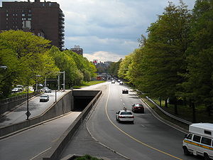
The Storrow Drive Tunnel, through which Storrow Drive runs along the EsplanadeCharles River Reservation
The Charles River Reservation is a -long Massachusetts state park located along the banks of the Charles River in Boston, Cambridge, Watertown, and Newton. The park is managed by the Department of Conservation and Recreation . The portion of the Reservation between the Charles River Dam and the...
just north of Clarendon, Berkeley and Arlington Streets, has been deteriorating since it was built in 1951, and by mid-2007 the Department of Conservation and Recreation determined that repairing the tunnel may be impossible because it was not waterproofed when it was built, and damage in the intervening years has been significant. Consequently the tunnel may be rebuilt at a cost upward of $200 million, a project that would require closing critical sections of Storrow Drive to traffic.
Despite the chaos this would cause to drivers, it also could present an opportunity for the city to improve the area. For example, Boston Mayor Thomas Menino
Thomas Menino
Thomas Michael "Tom" Menino is the mayor of Boston, Massachusetts, United States and the city's first Italian-American mayor...
has proposed covering Storrow Drive near the pedestrian Fiedler Bridge, replacing the old bridge with a wide, ground-level park space that would better connect the green space of Boston's Public Garden
Boston Public Garden
The Public Garden, also known as Boston Public Garden, is a large park located in the heart of Boston, Massachusetts, adjacent to Boston Common.-History:...
with the Esplanade.
Other plans for the road include closing it to traffic Sunday mornings in the summer, much as is done across the river on Memorial Drive
Memorial Drive (Cambridge)
Memorial Drive runs along the north bank of the Charles River in Cambridge, Massachusetts. It is designated as U.S. Route 3 or Massachusetts Route 3 for its entire length, and Massachusetts Route 2 over the portion west of the Boston University Bridge....
. This would create a recreational area for walking, biking and roller blading on weekends, though some have criticized this proposal as unnecessary due to the presence of the Esplanade paths and the existing Memorial Drive road closure. The drive however is usually closed during the July fourth independence celebration at the Esplanade.
Exit list
Exits on Storrow Drive are unnumbered. Mileposts are a continuation from Soldiers Field RoadSoldiers Field Road
Soldiers Field Road is a major crosstown parkway in Boston, Massachusetts, running west to east from U.S. Route 20 in the neighborhood of Brighton to the Boston University Bridge...
.
| Mile | Destinations | Notes |
|---|---|---|
| Road continues as Soldiers Field Road Soldiers Field Road Soldiers Field Road is a major crosstown parkway in Boston, Massachusetts, running west to east from U.S. Route 20 in the neighborhood of Brighton to the Boston University Bridge... |
||
| 4.1 | University Road – Boston University Boston University Boston University is a private research university located in Boston, Massachusetts. With more than 4,000 faculty members and more than 31,000 students, Boston University is one of the largest private universities in the United States and one of Boston's largest employers... , Brookline |
Eastbound exit only. To  Route 2 Route 2Route 2 (Massachusetts) Route 2 is a major east–west state highway in Massachusetts, parts of which are sometimes known as the Cambridge and Concord Turnpike. Along with Route 9 and U.S. Route 20 to the south, these highways are the main alternatives to the Massachusetts Turnpike/I-90 toll highway... |
| 5.0 | Kenmore Square Kenmore Square Kenmore Square is a square in Boston, Massachusetts, United States, consisting of the intersection of several main avenues as well as several other cross streets, and Kenmore Station, an MBTA subway stop. Kenmore Square is close to or abuts Boston University, Fenway Park, and Lansdowne Street, a... , Fenway |
Old alignment of U.S. Route 1 U.S. Route 1 U.S. Route 1 is a major north–south U.S. Highway that serves the East Coast of the United States. It runs 2,377 miles from Fort Kent, Maine at the Canadian border south to Key West, Florida. U.S. 1 generally parallels Interstate 95, though it is significantly farther west between... . |
| 5.1 |  Route 2A Route 2ARoute 2A (Massachusetts) Route 2A exists in several sections of Massachusetts, mainly as parts of former Route 2 that have been moved or upgraded. Route 2A runs from Greenfield in the west to Boston in the east... (Massachusetts Avenue) – Cambridge |
Westbound exit only. |
| 6.0 |  Route 28 Route 28Route 28 (Massachusetts) Route 28 is a nominally south–north route in the U.S. state of Massachusetts, running from the town of Orleans via Boston to the New Hampshire state line in Methuen. Following the route from its nominally southern end, Route 28 initially heads south to the town of Chatham then turns west to... South – Copley Square Copley Square Copley Square is a public square located in the Back Bay neighborhood of Boston, Massachusetts, named for the donor of the land on which it was developed. The square is named for John Singleton Copley, a famous portrait painter of the late 18th century and native of Boston. A bronze statue of... , Back Bay |
Official eastern terminus of Storrow Drive. |
| Road continues as Embankment Road / Route 28 Route 28 (Massachusetts) Route 28 is a nominally south–north route in the U.S. state of Massachusetts, running from the town of Orleans via Boston to the New Hampshire state line in Methuen. Following the route from its nominally southern end, Route 28 initially heads south to the town of Chatham then turns west to... North |
||