

Stob a' Choire Mheadhoin
Encyclopedia
Scottish Highlands
The Highlands is an historic region of Scotland. The area is sometimes referred to as the "Scottish Highlands". It was culturally distinguishable from the Lowlands from the later Middle Ages into the modern period, when Lowland Scots replaced Scottish Gaelic throughout most of the Lowlands...
, it is situated 19 km east of Fort William in the Lochaber
Lochaber
District of Lochaber 1975 to 1996Highland council area shown as one of the council areas of ScotlandLochaber is one of the 16 ward management areas of the Highland Council of Scotland and one of eight former local government districts of the two-tier Highland region...
area of the Highland
Highland (council area)
Highland is a council area in the Scottish Highlands and is the largest local government area in both Scotland and the United Kingdom as a whole. It shares borders with the council areas of Moray, Aberdeenshire, Perth and Kinross, and Argyll and Bute. Their councils, and those of Angus and...
council area.
Overview
Stob a' Choire Mheadhoin reaches a height of 1105 metres (3625 feet) making it the 46th highest MunroMunro
A Munro is a mountain in Scotland with a height over . They are named after Sir Hugh Munro, 4th Baronet , who produced the first list of such hills, known as Munros Tables, in 1891. A Munro top is a summit over 3,000 ft which is not regarded as a separate mountain...
. It is closely associated with the adjoining peak of Stob Coire Easain
Stob Coire Easain
Stob Coire Easain is a Scottish Munro mountain which reaches a height of 1115 metres , situated 18 kilometres east of Fort William. It stands on the western side of Loch Treig, along with its "twin", the Munro Stob a' Choire Mheadhoin...
which is just 10 metres higher and stands one km to the SW across a high col
Mountain pass
A mountain pass is a route through a mountain range or over a ridge. If following the lowest possible route, a pass is locally the highest point on that route...
with a height of approximately 965 metres. The two are usually climbed together and have the informal nicknames of “The Easains” or “The Stob Coires”.
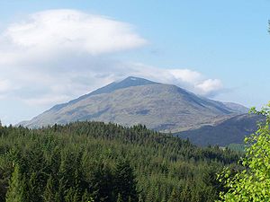
Some people have made the point that Stob a' Choire Mheadhoin is fortunate to be regarded as a separate mountain and could easily just be a subsidiary “top” of Stob Coire Easain, indeed the hill was not even mentioned on older maps from around 1900, just being shown as unnamed summit. However its dominating presence above Glen Spean has ensured that it has been regarded as a distinct and separate peak ever since the Munro Tables were first formulated in 1891. The best views of Stob a' Choire Mheadhoin are from the NE from where it is seen as a separate mountain. The view from the Laggan Dam
Laggan Dam
Laggan Dam is a dam located on the River Spean south west of Loch Laggan in the Scottish Highlands. The dam is 700 feet long and rises 170 feet above its foundations, and is part of the Lochaber hydro-electric scheme...
shows it as a conical peak while from Stob Coire Sgriodain on the opposite side of Loch Treig, the mountain shows the steep slopes which fall into the loch and its impressive craggy Coire
Cirque
Cirque may refer to:* Cirque, a geological formation* Makhtesh, an erosional landform found in the Negev desert of Israel and Sinai of Egypt*Cirque , an album by Biosphere* Cirque Corporation, a company that makes touchpads...
Meadhon which gives the mountain its name which translates as “Peak of the Middle Corrie“.
Geography
Stob a' Choire Mheadhoin has a long NE ridge which descends for over five km to the hamlet of Fersit at the head of Loch Treig. This ridge is the most common route of ascent and though mostly a moderate gradient it does have several steep sections, most notably the rocky climb up to Meall Cian Dearg which requires some mild scramblingScrambling
Scrambling is a method of ascending rocky faces and ridges. It is an ambiguous term that lies somewhere between hillwalking and rock climbing. It is often distinguished from hillwalking by defining a scramble as a route where hands must be used in the ascent...
. The mountains eastern flank falls steeply to Loch Treig with the slope rising from loch side to summit for 850 metres and an average gradient of over 30 degrees. These slopes are well seen when travelling on the West Highland Railway
West Highland Railway
The West Highland Railway was one of the last main lines to be built in Scotland. It is one of the most scenic railway lines in Britain, linking Fort William on the west coast to Glasgow. It was originally operated by the North British Railway.- History :...
on the east side of the loch.
A ridge goes SW from the summit to connect to the mountains twin Munro of Stob Coire Easain, this ridge hugs the lip of the impressive Coire Easain Beag which stands between the two mountains. This corrie has patches of red rock on its upper slopes especially on its Stob a' Choire Mheadhoin side, a point on the ridge at the head of the corrie is actually named Càrn Dearg (Red Cairn) on the OS
Ordnance Survey
Ordnance Survey , an executive agency and non-ministerial government department of the Government of the United Kingdom, is the national mapping agency for Great Britain, producing maps of Great Britain , and one of the world's largest producers of maps.The name reflects its creation together with...
map. There are several corries on the eastern side of the mountain, the most impressive of these by far is Coire Meadhon which falls directly from the summit with steep crags on its southern side. The northern slopes of the mountain descend into Coire Laire which is drained by the Allt Laire which goes north to join the River Spean as does all rainfall from the mountain.
Ascents
The most popular starting point for the ascent of Stob a' Choire Mheadhoin is the small hamlet of Fersit at grid reference , from there the long NE ridge can be accessed and followed to the summit. An alternative ascent can be made from Corrour railway stationCorrour railway station
Corrour railway station is a railway station on the West Highland Line,Scotland. It is situated near Loch Ossian and Loch Treig, on the Corrour Estate. It is the highest mainline railway station in the United Kingdom.- Location :...
utilising the West Highland Railway
West Highland Railway
The West Highland Railway was one of the last main lines to be built in Scotland. It is one of the most scenic railway lines in Britain, linking Fort William on the west coast to Glasgow. It was originally operated by the North British Railway.- History :...
. This is a long walk of around 30 km and involves a substantial hike in from the station around the head of Loch Treig to reach the foot of Stob Coire Easain which is climbed first before continuing over Stob a' Choire Mheadhoin to reach Tulloch railway station
Tulloch railway station
Tulloch railway station is a rural railway station in the Highland region of Scotland. This station is on the West Highland Line, north of .- History :...
for the evening train.