

Stearns County, Minnesota
Encyclopedia
As of the census
of 2000, there were 133,166 people, 47,604 households, and 32,132 families residing in the county. The population density
was 99 people per square mile (38/km²). There were 50,291 housing units at an average density of 37 per square mile (14/km²). The racial makeup of the county was 95.99% White
, 0.83% Black
or African American
, 0.26% Native American
, 1.58% Asian
, 0.03% Pacific Islander
, 0.47% from other races
, and 0.82% from two or more races. 1.37% of the population were Hispanic
or Latino
of any race. 56.9% were of German and 9.4% Norwegian ancestry according to Census 2000.
There were 47,604 households out of which 35.00% had children under the age of 18 living with them, 56.30% were married couples
living together, 7.50% had a female householder with no husband present, and 32.50% were non-families. 23.60% of all households were made up of individuals and 8.40% had someone living alone who was 65 years of age or older. The average household size was 2.64 and the average family size was 3.15.
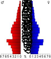 In the county the population was spread out with 25.70% under the age of 18, 16.10% from 18 to 24, 28.00% from 25 to 44, 19.10% from 45 to 64, and 11.00% who were 65 years of age or older. The median age was 32 years. For every 100 females there were 101.20 males. For every 100 females age 18 and over, there were 99.80 males.
The median income for a household in the county was $42,426, and the median income for a family was $51,553. Males had a median income of $34,268 versus $23,393 for females. The per capita income
for the county was $19,211. About 4.30% of families and 8.70% of the population were below the poverty line, including 6.70% of those under age 18 and 8.60% of those age 65 or over.
† Although mainly in Stearns County, the city extends into a neighboring county.
‡ These cities are based in an adjacent county, but extend into Stearns County.
Census
A census is the procedure of systematically acquiring and recording information about the members of a given population. It is a regularly occurring and official count of a particular population. The term is used mostly in connection with national population and housing censuses; other common...
of 2000, there were 133,166 people, 47,604 households, and 32,132 families residing in the county. The population density
Population density
Population density is a measurement of population per unit area or unit volume. It is frequently applied to living organisms, and particularly to humans...
was 99 people per square mile (38/km²). There were 50,291 housing units at an average density of 37 per square mile (14/km²). The racial makeup of the county was 95.99% White
Race (United States Census)
Race and ethnicity in the United States Census, as defined by the Federal Office of Management and Budget and the United States Census Bureau, are self-identification data items in which residents choose the race or races with which they most closely identify, and indicate whether or not they are...
, 0.83% Black
Race (United States Census)
Race and ethnicity in the United States Census, as defined by the Federal Office of Management and Budget and the United States Census Bureau, are self-identification data items in which residents choose the race or races with which they most closely identify, and indicate whether or not they are...
or African American
Race (United States Census)
Race and ethnicity in the United States Census, as defined by the Federal Office of Management and Budget and the United States Census Bureau, are self-identification data items in which residents choose the race or races with which they most closely identify, and indicate whether or not they are...
, 0.26% Native American
Race (United States Census)
Race and ethnicity in the United States Census, as defined by the Federal Office of Management and Budget and the United States Census Bureau, are self-identification data items in which residents choose the race or races with which they most closely identify, and indicate whether or not they are...
, 1.58% Asian
Race (United States Census)
Race and ethnicity in the United States Census, as defined by the Federal Office of Management and Budget and the United States Census Bureau, are self-identification data items in which residents choose the race or races with which they most closely identify, and indicate whether or not they are...
, 0.03% Pacific Islander
Race (United States Census)
Race and ethnicity in the United States Census, as defined by the Federal Office of Management and Budget and the United States Census Bureau, are self-identification data items in which residents choose the race or races with which they most closely identify, and indicate whether or not they are...
, 0.47% from other races
Race (United States Census)
Race and ethnicity in the United States Census, as defined by the Federal Office of Management and Budget and the United States Census Bureau, are self-identification data items in which residents choose the race or races with which they most closely identify, and indicate whether or not they are...
, and 0.82% from two or more races. 1.37% of the population were Hispanic
Race (United States Census)
Race and ethnicity in the United States Census, as defined by the Federal Office of Management and Budget and the United States Census Bureau, are self-identification data items in which residents choose the race or races with which they most closely identify, and indicate whether or not they are...
or Latino
Race (United States Census)
Race and ethnicity in the United States Census, as defined by the Federal Office of Management and Budget and the United States Census Bureau, are self-identification data items in which residents choose the race or races with which they most closely identify, and indicate whether or not they are...
of any race. 56.9% were of German and 9.4% Norwegian ancestry according to Census 2000.
There were 47,604 households out of which 35.00% had children under the age of 18 living with them, 56.30% were married couples
Marriage
Marriage is a social union or legal contract between people that creates kinship. It is an institution in which interpersonal relationships, usually intimate and sexual, are acknowledged in a variety of ways, depending on the culture or subculture in which it is found...
living together, 7.50% had a female householder with no husband present, and 32.50% were non-families. 23.60% of all households were made up of individuals and 8.40% had someone living alone who was 65 years of age or older. The average household size was 2.64 and the average family size was 3.15.
The median income for a household in the county was $42,426, and the median income for a family was $51,553. Males had a median income of $34,268 versus $23,393 for females. The per capita income
Per capita income
Per capita income or income per person is a measure of mean income within an economic aggregate, such as a country or city. It is calculated by taking a measure of all sources of income in the aggregate and dividing it by the total population...
for the county was $19,211. About 4.30% of families and 8.70% of the population were below the poverty line, including 6.70% of those under age 18 and 8.60% of those age 65 or over.
Cities and towns
| Cities | Townships | ||
|---|---|---|---|
|
Paynesville, Minnesota As of the census of 2000, there were 2,267 people, 934 households, and 594 families residing in the city. The population density was 1,715.2 people per square mile . There were 984 housing units at an average density of 744.5 per square mile... Richmond, Minnesota Richmond is a city in Stearns County, Minnesota, United States. The population was 1,422 at the 2010 census. Richmond is part of the St. Cloud Metropolitan Statistical Area.-Geography:... Rockville, Minnesota Rockville is a city in Stearns County, Minnesota, United States. The population was 2,448 at the 2010 census. It is part of the St. Cloud Metropolitan Statistical Area.... Roscoe, Minnesota Roscoe is a city in Stearns County, Minnesota, United States. The population was 102 at the 2010 census. It is part of the St. Cloud Metropolitan Statistical Area.-Geography:... Sartell, Minnesota Sartell is a city in Benton and Stearns counties in the U.S. state of Minnesota. It is part of the St. Cloud Metropolitan Statistical Area. The population was 15,876 at the 2010 census, making it St. Cloud's most populous suburb and the largest city in the central Minnesota region after St... † Sauk Centre, Minnesota As of the census of 2000, there were 3,930 people, 1,616 households, and 1,042 families residing in the city. The population density was 1,057.2 people per square mile . There were 1,709 housing units at an average density of 459.7 per square mile... Spring Hill, Minnesota Spring Hill is a city in Stearns County, Minnesota, USA. The population was 85 at the 2010 census. It is part of the St. Cloud Metropolitan Statistical Area.Minnesota State Highway 4 serves as a main arterial route in the community.-Geography:... St. Joseph, Minnesota As of the census of 2000, there were 4,681 people, 1,120 households, and 712 families residing in the city. The population density was 2,517.4 people per square mile . There were 1,147 housing units at an average density of 616.8 per square mile... St. Martin, Minnesota St. Martin is a city in Stearns County, Minnesota, United States. The population was 278 at the 2000 census. It is part of the St. Cloud Metropolitan Statistical Area.-Geography:... St. Rosa, Minnesota Saint Rosa is a city in Stearns County, Minnesota, United States. The population was 44 at the 2000 census. It is part of the St. Cloud Metropolitan Statistical Area.-Geography:... St. Stephen, Minnesota Saint Stephen is a city in Stearns County, Minnesota, United States. The population was 860 at the 2000 census. It is part of the Saint Cloud Metropolitan Statistical Area.-Geography:... Waite Park, Minnesota As of the census of 2000, there were 6,568 people, 2,967 households, and 1,536 families residing in the city. The population density was 841.0 people per square mile . There were 3,065 housing units at an average density of 392.5 per square mile... |
Lake George Township, Stearns County, Minnesota Lake George Township is a township in Stearns County, Minnesota, United States. The population was 371 at the 2000 census.-Geography:According to the United States Census Bureau, the township has a total area of , of which, of it is land and of it is water.-Demographics:As of the census of 2000,... |
|
† Although mainly in Stearns County, the city extends into a neighboring county.
‡ These cities are based in an adjacent county, but extend into Stearns County.