

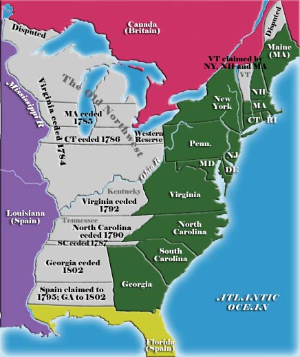
State cessions
Encyclopedia

United States
The United States of America is a federal constitutional republic comprising fifty states and a federal district...
that the separate states ceded to the federal government
Federal government of the United States
The federal government of the United States is the national government of the constitutional republic of fifty states that is the United States of America. The federal government comprises three distinct branches of government: a legislative, an executive and a judiciary. These branches and...
in the late 18th and early 19th century. The cession of these lands, which for the most part lay between the Appalachian Mountains
Appalachian Mountains
The Appalachian Mountains #Whether the stressed vowel is or ,#Whether the "ch" is pronounced as a fricative or an affricate , and#Whether the final vowel is the monophthong or the diphthong .), often called the Appalachians, are a system of mountains in eastern North America. The Appalachians...
and the Mississippi River
Mississippi River
The Mississippi River is the largest river system in North America. Flowing entirely in the United States, this river rises in western Minnesota and meanders slowly southwards for to the Mississippi River Delta at the Gulf of Mexico. With its many tributaries, the Mississippi's watershed drains...
, was key to establishing a harmonious union among the former British colonies.
The areas ceded comprise 236,825,600 acres (958,399 km²), or 10.4 percent of current United States territory
United States territory
United States territory is any extent of region under the jurisdiction of the federal government of the United States, including all waters including all U.S. Naval carriers. The United States has traditionally proclaimed the sovereign rights for exploring, exploiting, conserving, and managing its...
, and make up all or part of 10 states.
Background
Most of the British colonies on the east coast of North America were established in the 17th and early 18th century, when geographical knowledge of North America was incomplete. Many of these colonies were established by royal proclamation or charter that defined their boundaries as stretching "from sea to sea"; others did not have western boundaries established at all. These colonies thus ended up with theoretical extents that overlapped each other, and conflicted with the claims and settlements established by other European powers.By the time of the American Revolution
American Revolution
The American Revolution was the political upheaval during the last half of the 18th century in which thirteen colonies in North America joined together to break free from the British Empire, combining to become the United States of America...
, the boundaries between the various colonies had been for the most part surveyed and agreed upon in the eastern part of the country, where European settlement was densest. (The one notable exception to this trend was the ongoing dispute between New York
New York
New York is a state in the Northeastern region of the United States. It is the nation's third most populous state. New York is bordered by New Jersey and Pennsylvania to the south, and by Connecticut, Massachusetts and Vermont to the east...
and New Hampshire
New Hampshire
New Hampshire is a state in the New England region of the northeastern United States of America. The state was named after the southern English county of Hampshire. It is bordered by Massachusetts to the south, Vermont to the west, Maine and the Atlantic Ocean to the east, and the Canadian...
over the land that would eventually become Vermont
Vermont
Vermont is a state in the New England region of the northeastern United States of America. The state ranks 43rd in land area, , and 45th in total area. Its population according to the 2010 census, 630,337, is the second smallest in the country, larger only than Wyoming. It is the only New England...
.) The British government's Royal Proclamation of 1763
Royal Proclamation of 1763
The Royal Proclamation of 1763 was issued October 7, 1763, by King George III following Great Britain's acquisition of French territory in North America after the end of the French and Indian War/Seven Years' War...
, while not resolving the disputes over the colonies' trans-Appalachian claims, sought to cool them by placing significant restrictions on white settlement in the region. The proclamation was largely ignored on the ground, however, and various frontier settlement enterprises, owing allegiance to conflicting colonial governments, continued.
The claims of the colonies corresponded in varying degrees to the actual reality on the ground in the west at the eve of the Revolution. Kentucky
Kentucky
The Commonwealth of Kentucky is a state located in the East Central United States of America. As classified by the United States Census Bureau, Kentucky is a Southern state, more specifically in the East South Central region. Kentucky is one of four U.S. states constituted as a commonwealth...
, for instance, was organized into a county of Virginia
Kentucky County, Virginia
Kentucky County was formed by the Commonwealth of Virginia by dividing Fincastle County into three new counties: Kentucky, Washington, and Montgomery, effective December 31, 1776. Four years later Kentucky County was abolished on June 30, 1780, when it was divided into Fayette, Jefferson, and...
in 1776, with Virginia
Virginia
The Commonwealth of Virginia , is a U.S. state on the Atlantic Coast of the Southern United States. Virginia is nicknamed the "Old Dominion" and sometimes the "Mother of Presidents" after the eight U.S. presidents born there...
serving as practical sovereign over the area right up until its admission into the Union as a separate state in 1792. Massachusetts
Massachusetts
The Commonwealth of Massachusetts is a state in the New England region of the northeastern United States of America. It is bordered by Rhode Island and Connecticut to the south, New York to the west, and Vermont and New Hampshire to the north; at its east lies the Atlantic Ocean. As of the 2010...
' claims to land in modern-day Michigan and Wisconsin, by contrast, amounted to little more than lines drawn on a map.
The resolution of the claims
The Treaty of ParisTreaty of Paris (1783)
The Treaty of Paris, signed on September 3, 1783, ended the American Revolutionary War between Great Britain on the one hand and the United States of America and its allies on the other. The other combatant nations, France, Spain and the Dutch Republic had separate agreements; for details of...
that ended the American Revolution established American sovereignty over the land between the Appalachians and the Mississippi; the jobs of determining how that land should be governed, and how the conflicting claims to it by several of the states should be resolved, were one of the first major tasks facing the new nation.
The potential for trouble arising from these claims were twofold. One problem was obvious: in many cases more than one state laid claim to the same piece of territory, but clearly only one would be ultimately recognized as the owner. The other conflict also threatened the peace of the new union. Only seven of the thirteen states had western land claims, and the other, "landless" states were fearful of being overwhelmed by states that controlled vast stretches of the new frontier. Virginia in particular, which already encompassed 1 in 5 inhabitants of the new nation, laid claim to modern-day Kentucky, Indiana
Indiana
Indiana is a US state, admitted to the United States as the 19th on December 11, 1816. It is located in the Midwestern United States and Great Lakes Region. With 6,483,802 residents, the state is ranked 15th in population and 16th in population density. Indiana is ranked 38th in land area and is...
, and Illinois
Illinois
Illinois is the fifth-most populous state of the United States of America, and is often noted for being a microcosm of the entire country. With Chicago in the northeast, small industrial cities and great agricultural productivity in central and northern Illinois, and natural resources like coal,...
, and the smaller states feared that it would come to completely dominate the union.
In the end, most of the trans-Appalachian land claims were ceded to the Federal government between 1781 and 1787; New York, New Hampshire, and the hitherto unrecognized Vermont government resolved their squabbles by 1791, and Kentucky was separated from Virginia and made into a new state in 1792. The cessions were not entirely selfless—in some cases the cessions were made in exchange for federal assumption of the states' Revolutionary War debts—but the states' reasonably graceful cessions of their often-conflicting claims prevented early, perhaps catastrophic, rifts among the states of the young Republic, and assuaged the fears of the "landless" states enough to convince them to ratify the new United States Constitution
United States Constitution
The Constitution of the United States is the supreme law of the United States of America. It is the framework for the organization of the United States government and for the relationship of the federal government with the states, citizens, and all people within the United States.The first three...
. The cessions also set the stage for the settlement of the Upper Midwest
Upper Midwest
The Upper Midwest is a region in the northern portion of the U.S. Census Bureau's Midwestern United States. It is largely a sub-region of the midwest. Although there are no uniformly agreed-upon boundaries, the region is most commonly used to refer to the states of Minnesota, Wisconsin, and...
and the expansion of the U.S. into the center of the North America
North America
North America is a continent wholly within the Northern Hemisphere and almost wholly within the Western Hemisphere. It is also considered a northern subcontinent of the Americas...
n continent, and also established the pattern by which land newly acquired by the United States would be organized into new states rather than attached to old ones.
Georgia
Georgia (U.S. state)
Georgia is a state located in the southeastern United States. It was established in 1732, the last of the original Thirteen Colonies. The state is named after King George II of Great Britain. Georgia was the fourth state to ratify the United States Constitution, on January 2, 1788...
held on to its claims over trans-Appalachian land for another decade, and this claim was complicated by the fact that much of the land was also disputed between the United States and Spain
Spain
Spain , officially the Kingdom of Spain languages]] under the European Charter for Regional or Minority Languages. In each of these, Spain's official name is as follows:;;;;;;), is a country and member state of the European Union located in southwestern Europe on the Iberian Peninsula...
. When Georgia finally sold the land west of its current boundaries to the United States for cash in 1802, the last phase of western cessions was complete.
New YorkNew YorkNew York is a state in the Northeastern region of the United States. It is the nation's third most populous state. New York is bordered by New Jersey and Pennsylvania to the south, and by Connecticut, Massachusetts and Vermont to the east...
- Date ceded: 1780-02-19
- Date accepted: 1782-10-29
- Claims, cessions and dispute resolutions: Ceded claims west of Lake OntarioLake OntarioLake Ontario is one of the five Great Lakes of North America. It is bounded on the north and southwest by the Canadian province of Ontario, and on the south by the American state of New York. Ontario, Canada's most populous province, was named for the lake. In the Wyandot language, ontarío means...
, sold Erie TriangleErie TriangleThe Erie Triangle is a tract of American land that was the subject of several competing colonial-era claims and which was eventually acquired by the U.S. federal government and sold to Pennsylvania so that the state would have access to a freshwater port on Lake Erie...
to PennsylvaniaPennsylvaniaThe Commonwealth of Pennsylvania is a U.S. state that is located in the Northeastern and Mid-Atlantic regions of the United States. The state borders Delaware and Maryland to the south, West Virginia to the southwest, Ohio to the west, New York and Ontario, Canada, to the north, and New Jersey to...
, stopped squabbling with New Hampshire over what would become VermontVermontVermont is a state in the New England region of the northeastern United States of America. The state ranks 43rd in land area, , and 45th in total area. Its population according to the 2010 census, 630,337, is the second smallest in the country, larger only than Wyoming. It is the only New England...
.
VirginiaVirginiaThe Commonwealth of Virginia , is a U.S. state on the Atlantic Coast of the Southern United States. Virginia is nicknamed the "Old Dominion" and sometimes the "Mother of Presidents" after the eight U.S. presidents born there...
- Date ceded: 1781-01-02
- Date completed: 1784-03-01
- Claims and cessions: Ceded its territory north and west of the Ohio River, which was to become the Northwest TerritoryNorthwest TerritoryThe Territory Northwest of the River Ohio, more commonly known as the Northwest Territory, was an organized incorporated territory of the United States that existed from July 13, 1787, until March 1, 1803, when the southeastern portion of the territory was admitted to the Union as the state of Ohio...
. The land south and east of the Ohio, known as KentuckyKentuckyThe Commonwealth of Kentucky is a state located in the East Central United States of America. As classified by the United States Census Bureau, Kentucky is a Southern state, more specifically in the East South Central region. Kentucky is one of four U.S. states constituted as a commonwealth...
, was retained by Virginia and organized into counties: FayetteFayette County, KentuckyFayette County is a county located in the U.S. state of Kentucky. The population was 295,083 in the 2010 Census. Its territory, population and government are coextensive with the city of Lexington, which also serves as county seat....
, JeffersonJefferson County, KentuckyAs of the census of 2000, there were 693,604 people, 287,012 households, and 183,113 families residing in the county. The population density was . There were 305,835 housing units at an average density of...
and LincolnLincoln County, KentuckyLincoln County is a county located in the U.S. state of Kentucky. The population was 24,742 in the 2010 Cesus. Its county seat is Stanford. Lincoln is a prohibition or "dry county" and is part of the Danville Micropolitan Statistical Area.- History :...
counties. Kentucky was finally admitted in 1792, after the adoption of the U.S. Constitution and multiple attempts to agree upon a state constitution that was acceptable to both Virginia and the U.S. Congress.
MassachusettsMassachusettsThe Commonwealth of Massachusetts is a state in the New England region of the northeastern United States of America. It is bordered by Rhode Island and Connecticut to the south, New York to the west, and Vermont and New Hampshire to the north; at its east lies the Atlantic Ocean. As of the 2010...
- Date ceded: 1784-11-13
- Date completed: 1785-04-19
- Claims and cessions: Ceded swath between present north and south border-latitudes across present-day MichiganMichiganMichigan is a U.S. state located in the Great Lakes Region of the United States of America. The name Michigan is the French form of the Ojibwa word mishigamaa, meaning "large water" or "large lake"....
and WisconsinWisconsinWisconsin is a U.S. state located in the north-central United States and is part of the Midwest. It is bordered by Minnesota to the west, Iowa to the southwest, Illinois to the south, Lake Michigan to the east, Michigan to the northeast, and Lake Superior to the north. Wisconsin's capital is...
, to which it was entitled by its interpretation of its original sea-to-sea grant from the British crown.
ConnecticutConnecticutConnecticut is a state in the New England region of the northeastern United States. It is bordered by Rhode Island to the east, Massachusetts to the north, and the state of New York to the west and the south .Connecticut is named for the Connecticut River, the major U.S. river that approximately...
- Date ceded: 1786-05-11
- Date completed: 1786-05-28
- Claims and cessions: Ceded land from western border to Mississippi RiverMississippi RiverThe Mississippi River is the largest river system in North America. Flowing entirely in the United States, this river rises in western Minnesota and meanders slowly southwards for to the Mississippi River Delta at the Gulf of Mexico. With its many tributaries, the Mississippi's watershed drains...
, notably the Wyoming ValleyWyoming ValleyWyoming Valley is a region of northeastern Pennsylvania. As a metropolitan area, it is also known as the Scranton/Wilkes-Barre area, after its principal cities, Scranton and Wilkes-Barre....
disputed in the Pennamite-Yankee WarPennamite-Yankee WarThe Pennamite-Yankee War was the intermittent conflict between 1769 and 1799 between settlers from Connecticut who claimed the land along the North Branch of the Susquehanna River in the present Wyoming Valley, and settlers from Pennsylvania who laid claim to the same lands.-Grants to Connecticut...
, but held back Connecticut Western ReserveConnecticut Western ReserveThe Connecticut Western Reserve was land claimed by Connecticut from 1662 to 1800 in the Northwest Territory in what is now northeastern Ohio.-History:...
in Ohio CountryOhio CountryThe Ohio Country was the name used in the 18th century for the regions of North America west of the Appalachian Mountains and in the region of the upper Ohio River south of Lake Erie...
until 1800.
South CarolinaSouth CarolinaSouth Carolina is a state in the Deep South of the United States that borders Georgia to the south, North Carolina to the north, and the Atlantic Ocean to the east. Originally part of the Province of Carolina, the Province of South Carolina was one of the 13 colonies that declared independence...
- Date ceded: 1787-03-08
- Date completed: 1787-08-09
- Claims and cessions: The State of South Carolina claimed a narrow, approximately 12-mile strip of land from its northwestern tip westward to the Mississippi RiverMississippi RiverThe Mississippi River is the largest river system in North America. Flowing entirely in the United States, this river rises in western Minnesota and meanders slowly southwards for to the Mississippi River Delta at the Gulf of Mexico. With its many tributaries, the Mississippi's watershed drains...
, running north of the State of GeorgiaGeorgia (U.S. state)Georgia is a state located in the southeastern United States. It was established in 1732, the last of the original Thirteen Colonies. The state is named after King George II of Great Britain. Georgia was the fourth state to ratify the United States Constitution, on January 2, 1788...
and south of the State of North Carolina (which included the State of Tennessee until 1796), and the northern edges of what would later become MississippiMississippiMississippi is a U.S. state located in the Southern United States. Jackson is the state capital and largest city. The name of the state derives from the Mississippi River, which flows along its western boundary, whose name comes from the Ojibwe word misi-ziibi...
and AlabamaAlabamaAlabama is a state located in the southeastern region of the United States. It is bordered by Tennessee to the north, Georgia to the east, Florida and the Gulf of Mexico to the south, and Mississippi to the west. Alabama ranks 30th in total land area and ranks second in the size of its inland...
. South Carolina cedeed this land to Georgia and to the Federal Government.
Note that the claim by South Carolina had been for land between the headwaters of the Savannah River
Savannah River
The Savannah River is a major river in the southeastern United States, forming most of the border between the states of South Carolina and Georgia. Two tributaries of the Savannah, the Tugaloo River and the Chattooga River, form the northernmost part of the border...
and the southern boundary of North Carolina
North Carolina
North Carolina is a state located in the southeastern United States. The state borders South Carolina and Georgia to the south, Tennessee to the west and Virginia to the north. North Carolina contains 100 counties. Its capital is Raleigh, and its largest city is Charlotte...
, and thence westward. In fact, however, later and more accurate surveying
Surveying
See Also: Public Land Survey SystemSurveying or land surveying is the technique, profession, and science of accurately determining the terrestrial or three-dimensional position of points and the distances and angles between them...
showed that the headwaters of the Savannah River actually extended into North Carolina. This meant that this strip of land for South Carolina had actually been illusory.
North CarolinaNorth CarolinaNorth Carolina is a state located in the southeastern United States. The state borders South Carolina and Georgia to the south, Tennessee to the west and Virginia to the north. North Carolina contains 100 counties. Its capital is Raleigh, and its largest city is Charlotte...
- Date ceded: 1789-12-22
- Date effective: 1790-02-25
- Claims and cessions: Ceded its western claim that extended to the Mississippi River to the Federal Government. This became the Southwest TerritorySouthwest TerritoryThe Territory South of the River Ohio, more commonly known as the Southwest Territory, was an organized incorporated territory of the United States that existed from May 26, 1790, until June 1, 1796, when it was admitted to the United States as the State of Tennessee.The Southwest Territory was...
, which just six years later was admitted to the Union as the State of Tennessee in 1796.
State of GeorgiaGeorgia (U.S. state)Georgia is a state located in the southeastern United States. It was established in 1732, the last of the original Thirteen Colonies. The state is named after King George II of Great Britain. Georgia was the fourth state to ratify the United States Constitution, on January 2, 1788...
- Georgia ceded this land on 1802-04-24, 12 years after all other western land cessions had been :completed (except for Connecticut's "Western Reserve"Connecticut Western ReserveThe Connecticut Western Reserve was land claimed by Connecticut from 1662 to 1800 in the Northwest Territory in what is now northeastern Ohio.-History:...
- which was given up the year 1800). - Ratified by the Georgia Legislature on 1802-06-16
- This land consisted of the "Yazoo landsYazoo landsThe Yazoo lands were the sparsely-populated central and western areas of the U.S. state of Georgia, when its western border stretched back to the Mississippi River. It was named for the Yazoo tribe of Native Americans. Several other places and things were named Yazoo, either for or along with the...
", lying between the 35th parallel35th parallel northThe 35th parallel north is a circle of latitude that is 35 degrees north of the Earth's equatorial plane. It crosses Africa, the Mediterranean Sea, Asia, the Pacific Ocean, North America and the Atlantic Ocean....
and the 31st parallel31st parallel northThe 31st parallel north is a circle of latitude that is 31 degrees north of the Earth's equatorial plane. It crosses Africa, Asia, the Pacific Ocean, North America and the Atlantic Ocean.Part of the border between Iran and Iraq is defined by the parallel....
of latitude westward through the Mississippi River. Its eastern boundary was the present western boundary of Georgia with Alabama. - Unique among these "cessions", Georgia charged the U.S. Government $1.25 million for this land, and apparently, this sum was paid.
Claimless states
Note: Some of these states might have had some claims to western (or other) lands during the colonial eraColonial America
The colonial history of the United States covers the history from the start of European settlement and especially the history of the thirteen colonies of Britain until they declared independence in 1776. In the late 16th century, England, France, Spain and the Netherlands launched major...
, but by about 1785, they were no longer planning on expanding west at all.
- Commonwealth of Pennsylvania: It original land grant from the British Monarch to William PennWilliam PennWilliam Penn was an English real estate entrepreneur, philosopher, and founder of the Province of Pennsylvania, the English North American colony and the future Commonwealth of Pennsylvania. He was an early champion of democracy and religious freedom, notable for his good relations and successful...
was for the land between the 42nd parallel42nd parallel northThe 42nd parallel north is a circle of latitude that is 42 degrees north of the Earth's equatorial plane. It crosses Europe, the Mediterranean Sea, Asia, the Pacific Ocean, North America, and the Atlantic Ocean....
and the 38th parallel39th parallel northThe 39th parallel north is a circle of latitude that is 39 degrees north of the Earth's equatorial plane. It crosses Europe, the Mediterranean Sea, Asia, the Pacific Ocean, North America, and the Atlantic Ocean....
in latitude, and extending westward five degrees in longitudeLongitudeLongitude is a geographic coordinate that specifies the east-west position of a point on the Earth's surface. It is an angular measurement, usually expressed in degrees, minutes and seconds, and denoted by the Greek letter lambda ....
. This land grant extended from the western and northwestern boundaries with New JerseyNew JerseyNew Jersey is a state in the Northeastern and Middle Atlantic regions of the United States. , its population was 8,791,894. It is bordered on the north and east by the state of New York, on the southeast and south by the Atlantic Ocean, on the west by Pennsylvania and on the southwest by Delaware...
and DelawareDelawareDelaware is a U.S. state located on the Atlantic Coast in the Mid-Atlantic region of the United States. It is bordered to the south and west by Maryland, and to the north by Pennsylvania...
westwards. Pennsylvania claimed the land of the northwestern Erie TriangleErie TriangleThe Erie Triangle is a tract of American land that was the subject of several competing colonial-era claims and which was eventually acquired by the U.S. federal government and sold to Pennsylvania so that the state would have access to a freshwater port on Lake Erie...
along Lake ErieLake ErieLake Erie is the fourth largest lake of the five Great Lakes in North America, and the tenth largest globally. It is the southernmost, shallowest, and smallest by volume of the Great Lakes and therefore also has the shortest average water residence time. It is bounded on the north by the...
, which had been ceded during 1781 - 85 to the Federal government by New York State and the Commonwealth of Massachusetts. The Federal government, in turn, sold this land to Pennsylvania in 1788. - New HampshireNew HampshireNew Hampshire is a state in the New England region of the northeastern United States of America. The state was named after the southern English county of Hampshire. It is bordered by Massachusetts to the south, Vermont to the west, Maine and the Atlantic Ocean to the east, and the Canadian...
: Claimed New Hampshire GrantsNew Hampshire GrantsThe New Hampshire Grants or Benning Wentworth Grants were land grants made between 1749 and 1764 by the provincial governor of New Hampshire, Benning Wentworth. The land grants, totaling about 135 , were made on land claimed by New Hampshire west of the Connecticut River, territory that was also...
- VermontVermontVermont is a state in the New England region of the northeastern United States of America. The state ranks 43rd in land area, , and 45th in total area. Its population according to the 2010 census, 630,337, is the second smallest in the country, larger only than Wyoming. It is the only New England...
. This was given up when Vermont was admitted to the Union as the 14th State in 1791. - Rhode IslandRhode IslandThe state of Rhode Island and Providence Plantations, more commonly referred to as Rhode Island , is a state in the New England region of the United States. It is the smallest U.S. state by area...
never did claim any land farther west. - DelawareDelawareDelaware is a U.S. state located on the Atlantic Coast in the Mid-Atlantic region of the United States. It is bordered to the south and west by Maryland, and to the north by Pennsylvania...
never did claim any land farther west, and its western boundary was part of the Mason-Dixon LineMason-Dixon lineThe Mason–Dixon Line was surveyed between 1763 and 1767 by Charles Mason and Jeremiah Dixon in the resolution of a border dispute between British colonies in Colonial America. It forms a demarcation line among four U.S. states, forming part of the borders of Pennsylvania, Maryland, Delaware, and...
. - MarylandMarylandMaryland is a U.S. state located in the Mid Atlantic region of the United States, bordering Virginia, West Virginia, and the District of Columbia to its south and west; Pennsylvania to its north; and Delaware to its east...
never did claim any land farther west, and the land to its west was part of the Commonwealth of Virginia - New JerseyNew JerseyNew Jersey is a state in the Northeastern and Middle Atlantic regions of the United States. , its population was 8,791,894. It is bordered on the north and east by the state of New York, on the southeast and south by the Atlantic Ocean, on the west by Pennsylvania and on the southwest by Delaware...
never did claim any land farther west, and its western boundary was established quite early along the Delaware RiverDelaware RiverThe Delaware River is a major river on the Atlantic coast of the United States.A Dutch expedition led by Henry Hudson in 1609 first mapped the river. The river was christened the South River in the New Netherland colony that followed, in contrast to the North River, as the Hudson River was then...
.
Texas

Republic of Texas
The Republic of Texas was an independent nation in North America, bordering the United States and Mexico, that existed from 1836 to 1846.Formed as a break-away republic from Mexico by the Texas Revolution, the state claimed borders that encompassed an area that included all of the present U.S...
joined the United States in 1845, it claimed a good deal of land that had not been under the de facto control of the Texan government
Texas
Texas is the second largest U.S. state by both area and population, and the largest state by area in the contiguous United States.The name, based on the Caddo word "Tejas" meaning "friends" or "allies", was applied by the Spanish to the Caddo themselves and to the region of their settlement in...
. Thus, there was a border dispute between Texas, Mexico
Mexico
The United Mexican States , commonly known as Mexico , is a federal constitutional republic in North America. It is bordered on the north by the United States; on the south and west by the Pacific Ocean; on the southeast by Guatemala, Belize, and the Caribbean Sea; and on the east by the Gulf of...
, and Native American tribes that the U.S. Government inherited upon the annexation of Texas. This was one of the causes of the Mexican-American War of 1846 - 47 (with others including the western land greed of the U.S., and another being the Mexican refusal to sell the land to the U.S.) After the American victory in this War, the Mexican government recognized American sovereignty over the disputed Texan lands and also ceded/sold the land extending to west to the Pacific Ocean
Pacific Ocean
The Pacific Ocean is the largest of the Earth's oceanic divisions. It extends from the Arctic in the north to the Southern Ocean in the south, bounded by Asia and Australia in the west, and the Americas in the east.At 165.2 million square kilometres in area, this largest division of the World...
in addition. The Mexican government was paid $25,000,000 in the terms of the Treaty of Guadalupe Hidalgo
Treaty of Guadalupe Hidalgo
The Treaty of Guadalupe Hidalgo is the peace treaty, largely dictated by the United States to the interim government of a militarily occupied Mexico City, that ended the Mexican-American War on February 2, 1848...
of 1848.
In addition, the maximalist land claims of the Republic of Texas did not set the northern and western borders of the State of Texas. Most, but not all, of its northern boundary had been set by a treaty between the United States and the Spanish Empire
Spanish Empire
The Spanish Empire comprised territories and colonies administered directly by Spain in Europe, in America, Africa, Asia and Oceania. It originated during the Age of Exploration and was therefore one of the first global empires. At the time of Habsburgs, Spain reached the peak of its world power....
- along the Red River. The treaty between the Republic of Texas
Republic of Texas
The Republic of Texas was an independent nation in North America, bordering the United States and Mexico, that existed from 1836 to 1846.Formed as a break-away republic from Mexico by the Texas Revolution, the state claimed borders that encompassed an area that included all of the present U.S...
and the United States
United States
The United States of America is a federal constitutional republic comprising fifty states and a federal district...
that admitted Texas to the Union gave the United States the right to divide up the Republic into no more than five states.
In an act of Congress, the Compromise of 1850
Compromise of 1850
The Compromise of 1850 was a package of five bills, passed in September 1850, which defused a four-year confrontation between the slave states of the South and the free states of the North regarding the status of territories acquired during the Mexican-American War...
, Texas gave up much of its proclaimed northern and western lands in return for debt relief, removing its conflicting claims from the U.S. territorial gains of the Mexican-American War. This ceded land eventually became portions of the states of Kansas
Kansas
Kansas is a US state located in the Midwestern United States. It is named after the Kansas River which flows through it, which in turn was named after the Kansa Native American tribe, which inhabited the area. The tribe's name is often said to mean "people of the wind" or "people of the south...
(1859), Colorado
Colorado
Colorado is a U.S. state that encompasses much of the Rocky Mountains as well as the northeastern portion of the Colorado Plateau and the western edge of the Great Plains...
(1876), Wyoming
Wyoming
Wyoming is a state in the mountain region of the Western United States. The western two thirds of the state is covered mostly with the mountain ranges and rangelands in the foothills of the Eastern Rocky Mountains, while the eastern third of the state is high elevation prairie known as the High...
(1890), Oklahoma
Oklahoma
Oklahoma is a state located in the South Central region of the United States of America. With an estimated 3,751,351 residents as of the 2010 census and a land area of 68,667 square miles , Oklahoma is the 28th most populous and 20th-largest state...
(1907), and New Mexico
New Mexico
New Mexico is a state located in the southwest and western regions of the United States. New Mexico is also usually considered one of the Mountain States. With a population density of 16 per square mile, New Mexico is the sixth-most sparsely inhabited U.S...
(1911).
See also
- Thirteen ColoniesThirteen ColoniesThe Thirteen Colonies were English and later British colonies established on the Atlantic coast of North America between 1607 and 1733. They declared their independence in the American Revolution and formed the United States of America...
- Yankee-Pennamite Wars
- Yazoo LandsYazoo landsThe Yazoo lands were the sparsely-populated central and western areas of the U.S. state of Georgia, when its western border stretched back to the Mississippi River. It was named for the Yazoo tribe of Native Americans. Several other places and things were named Yazoo, either for or along with the...
- Mason-Dixon LineMason-Dixon lineThe Mason–Dixon Line was surveyed between 1763 and 1767 by Charles Mason and Jeremiah Dixon in the resolution of a border dispute between British colonies in Colonial America. It forms a demarcation line among four U.S. states, forming part of the borders of Pennsylvania, Maryland, Delaware, and...
- Northwest TerritoryNorthwest TerritoryThe Territory Northwest of the River Ohio, more commonly known as the Northwest Territory, was an organized incorporated territory of the United States that existed from July 13, 1787, until March 1, 1803, when the southeastern portion of the territory was admitted to the Union as the state of Ohio...
- Ohio CountryOhio CountryThe Ohio Country was the name used in the 18th century for the regions of North America west of the Appalachian Mountains and in the region of the upper Ohio River south of Lake Erie...
- Illinois CountryIllinois CountryThe Illinois Country , also known as Upper Louisiana, was a region in what is now the Midwestern United States that was explored and settled by the French during the 17th and 18th centuries. The terms referred to the entire Upper Mississippi River watershed, though settlement was concentrated in...
- Historic regions of the United StatesHistoric regions of the United StatesThis is a list of historic regions of the United States.-Colonial era :-The Thirteen Colonies:* Connecticut Colony* Delaware Colony* Province of Georgia* Province of Maryland...
- United States territorial acquisitionsUnited States territorial acquisitionsThis is a simplified list of United States territorial acquisitions, beginning with American independence. Note that this list primarily concerns land acquired from other nation-states; the numerous territorial acquisitions from American Indians are not listed here.-1783-1848:*The 1783 Treaty of...
- Territorial evolution of the United StatesTerritorial evolution of the United StatesThis is a list of the evolution of the borders of the United States. This lists each change to the internal and external borders of the country, as well as status and name changes. It also shows the surrounding areas that eventually became part of the United States...