

Stainland
Encyclopedia
Stainland is a village in Calderdale
, West Yorkshire
, England
, some 4 miles (6.4 km) south of Halifax
, 4.5 miles (7.2 km) north-west of Huddersfield
and 2 miles (3.2 km) west of Elland
.
and Heptonstall
. With the industrial revolution, mills developed in the neighbouring valleys to take advantage of water power; however Stainland continued to act as a focus for the area. The village continued to thrive and a number of notable buildings were added to the street scene. With the decline in its agricultural and industrial function, Stainland is now less self-contained than it was and the proximity of the M62
has led to the development of a new residential role, housing people who work in the neighbouring towns. This, in turn, is leading to new pressures for change in the fabric of the village.
The name Stainland derives from Old norse
meaning Stony land, so it's unsurprising to learn that the land around Stainland isn't very fertile.
The village appears in the Domesday book
as Stanland.
and Sowood
and occupies a hilltop position at about 800 feet (243.8 m) on a spur which projects from the higher land of Pole Moor and Outlane
to the south. The main road through the village is Stainland Road, the B6112
.
Due to its altitude and remote location, places visible are (clockwise from north): King Cross
, Savile Park, Halifax
, Southowram
, Siddal, Greetland
, Elland Wood, Blackley
, Ainley Top
, Jagger Green, Thunnerley Wood, Old Lindley Moor, Outlane, parts of Sowood, Scammonden
, Krumlin, Barkisland
, Norland Moor and Norland
. On a clear day, Ovenden
, Queensbury
, Saddleworth Moor
and even Wyke
are visible.
Stainland is essentially linear: all the principal buildings face the main road which forms a central spine. There is not generally a building line to which development can conform and the road narrows at 'pinch points' where the buildings are closer. This leads to an unfolding series of vistas as one travels through the village. Much of the lesser domestic buildings has developed on minor lanes at right angles to the road and these dense clusters of houses provide areas of enclosure with occasional dramatic glimpses across open countryside. The architecture of Stainland, using local materials, represents all phases of the village's history.
Stainland is a conservation area
, which was designated on 30 November 1982.
, at the eastern side of Stainland, is often wrongly referred to as the main settlement. The boundary between Stainland and Holywell Green is 53°40′26"N 01°52′23"W, between West View and Bradley View.
Location grid
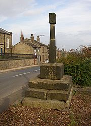
carved on a block of stone. The block is scooped out in the form of a cup but the cover that was formerly attached to it has been removed. The column is circular and plain without any of that rich, strange sculpture or scroll ornament which antiquarians generally attribute to Saxon
or Danish sculptures. Its height from the base to the top of the sculpture is about 10 feet (3 m), the column doesn't exceed 5 feet (1.5 m). Neither history nor tradition have preserved the date or purpose of its construction.
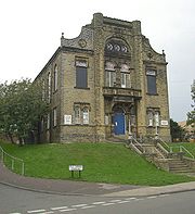 Stainland Mechanics' Institute was built by the Shaw family in 1883 by public description, "to improve the moral, social and intellectual habits of the inhabitants". The building was opened by the Mayor of Leeds on 7 June 1884. Over the years it suffered as income declined. By 1952, the trustees decided to sell the building but offered it to Elland UDC. In 1954, a Community Centre was formed by the Trustees. In 1967 it was taken over by Elland UDC. Some maintenance was undertaken but by 1974, when Calderdale MBC became the owners, it needed repairs. In 1977, the council demolished the twin towers at the entrance. Several surveys were carried out but £500,000 was required to bring it up to standard. A committee tried to raise this money but was not successful and the centre closed on 18 December 2009. The building was signed back to the council and declared surplus to requirements. In January 2011, councillors voted to sell the building as the cost to bring the building up to standard is too much.
's monumental The History and Antiquities of the Parish of Halifax, 1775. He gives no description but says a Roman Catholic chapel dedicated to St Helen, nearby had been converted into a cottage, but in its walls was a large stone known locally as 'the Cross'. Strangers, presumed to be Catholics, made pilgrimages to the well. Watson also possessed a deed which mentioned a grant made to Henry de Sacro Fonte de Staynland. dated between 1279 and 1324. The well was restored in 1843 in response to interest in drinking 'spa' water. The 'Halifax Guardian' for September 1842 described the scene around Well Head spa where crowds carrying drinking utensils jostled each other in their eagerness to take the waters. Well Head was the most popular of the Halifax spas but several other springs in the area were frequented. Similar scenes may have occurred around Stainland’s well. In the late 19th century the well was declining. The stone trough had cracked and was leaking. Local placenames reflect the importance of the well. The eastern end of the village is known as Holywell Green
, there is a pub called 'The Holywell Inn' and a 'St Helen’s Court'. The well was further restored in 1977 and the crumbling trough of the woodcut has been replaced by a solid modern one, no water flows into it.
 St. Andrew's C of E Church in the centre of the village was built c.1755 as a chapel for Stainland, Holywell Green
and Sowood
. The church tower is visible from Norland
and Blackley.
Stainland had three other chapels, Stainland Providence Chapel, Stainland Wesleyan Chapel and a mortuary chapel. The mortuary chapel was next to a graveyard that served the Providence Chapel. All three graveyards remain but only the Providence Chapel remains and was converted into nine houses. The mortuary chapel was demolished after the Providence Chapel became houses. The Wesleyan Chapel was demolished to make way for houses.
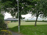
Stainland Recreation Ground (Stainland Rec or the Rec) lies west of the village centre and has two football pitches, a rugby pitch, a cricket ground, a bowling green, a tennis court, a five-a-side pitch, and a playground.
Stainland United FC play in the Halifax and District League First Division
. The club was formed in 1947 as Stainland Athletic and changed its name to Stainland United in 1980. In 1992 the club folded but reformed in 1997 and won the Halifax Premier Division in the 2006-07 season.
 Stainland Stags ARLFC play in the Pennine League Fifth Division
.
Stainland Cricket Club and Stainland Bowling Club share a pavilion at Stainland Recreational Ground. The pavilion was built in 2001 after the previous pavilion burnt down. The ground is called the Memorial Ground after it was given as a post-war gift in 1922. It is one of the biggest in the Halifax League. The played at Drury Lane for 40 years,. Stainland CC play in the Towergate Halifax Cricket League Second Division. Stainland won the Second Division title in 1979 and 2002.
Calderdale
The Metropolitan Borough of Calderdale is a metropolitan borough of West Yorkshire, England, through which the upper part of the River Calder flows, and from which it takes its name...
, West Yorkshire
West Yorkshire
West Yorkshire is a metropolitan county within the Yorkshire and the Humber region of England with a population of 2.2 million. West Yorkshire came into existence as a metropolitan county in 1974 after the passage of the Local Government Act 1972....
, England
England
England is a country that is part of the United Kingdom. It shares land borders with Scotland to the north and Wales to the west; the Irish Sea is to the north west, the Celtic Sea to the south west, with the North Sea to the east and the English Channel to the south separating it from continental...
, some 4 miles (6.4 km) south of Halifax
Halifax, West Yorkshire
Halifax is a minster town, within the Metropolitan Borough of Calderdale in West Yorkshire, England. It has an urban area population of 82,056 in the 2001 Census. It is well-known as a centre of England's woollen manufacture from the 15th century onward, originally dealing through the Halifax Piece...
, 4.5 miles (7.2 km) north-west of Huddersfield
Huddersfield
Huddersfield is a large market town within the Metropolitan Borough of Kirklees, in West Yorkshire, England, situated halfway between Leeds and Manchester. It lies north of London, and south of Bradford, the nearest city....
and 2 miles (3.2 km) west of Elland
Elland
Elland is a market town in Calderdale, in the county of West Yorkshire, England, south of Halifax, by the River Calder and the Calder and Hebble Navigation. The area of Elland was called Elant in the Domesday Book...
.
History
Early routes and tracks followed high ground to avoid the marshy and wooded valley bottoms and it was on one such high level packhorse route that Stainland developed. The Stainland Cross remains as evidence of man's activity there in the medieval times. An economy based principally on wool and textile production led Stainland to develop as a hilltop village in much the same way as SowerbySowerby, West Yorkshire
Sowerby is a village within the Metropolitan Borough of Calderdale, in West Yorkshire, England. It lies amongst the Pennines, contiguous with Sowerby Bridge, west-southwest of Halifax and west-northwest of Huddersfield....
and Heptonstall
Heptonstall
Heptonstall is a small village and civil parish within the Calderdale borough of West Yorkshire, England. The population of Heptonstall, including the hamlets of Colden and Slack, is 1,448. The town of Hebden Bridge lies directly to the southeast...
. With the industrial revolution, mills developed in the neighbouring valleys to take advantage of water power; however Stainland continued to act as a focus for the area. The village continued to thrive and a number of notable buildings were added to the street scene. With the decline in its agricultural and industrial function, Stainland is now less self-contained than it was and the proximity of the M62
M62 motorway
The M62 motorway is a west–east trans-Pennine motorway in Northern England, connecting the cities of Liverpool and Hull via Manchester and Leeds. The road also forms part of the unsigned Euroroutes E20 and E22...
has led to the development of a new residential role, housing people who work in the neighbouring towns. This, in turn, is leading to new pressures for change in the fabric of the village.
The name Stainland derives from Old norse
Old Norse
Old Norse is a North Germanic language that was spoken by inhabitants of Scandinavia and inhabitants of their overseas settlements during the Viking Age, until about 1300....
meaning Stony land, so it's unsurprising to learn that the land around Stainland isn't very fertile.
The village appears in the Domesday book
Domesday Book
Domesday Book , now held at The National Archives, Kew, Richmond upon Thames in South West London, is the record of the great survey of much of England and parts of Wales completed in 1086...
as Stanland.
Geography
Stainland is situated between Holywell GreenHolywell Green
Holywell Green is a small village in Calderdale, West Yorkshire, England. It is south of Halifax, north-west of Huddersfield and south-west of Elland.-History:...
and Sowood
Sowood, West Yorkshire
Sowood is a village in Calderdale, West Yorkshire, England. It is south of Halifax, north-west of Huddersfield and south-west of Elland.-Geography:...
and occupies a hilltop position at about 800 feet (243.8 m) on a spur which projects from the higher land of Pole Moor and Outlane
Outlane
Outlane is a village near Huddersfield, West Yorkshire, England with a population of 710 according to the 2001 census. It is situated north-west of the Huddersfield town centre...
to the south. The main road through the village is Stainland Road, the B6112
B roads in Zone 6 of the Great Britain numbering scheme
B roads are numbered routes in Great Britain of lesser importance than A roads. See the article Great Britain road numbering scheme for the rationale behind the numbers allocated.-Zone 6 :-Zone 6 :...
.
Due to its altitude and remote location, places visible are (clockwise from north): King Cross
King Cross
King Cross; originally the site of an ancient stone cross is a Ecclesiastical parish created in 1845 in the Metropolitan Borough of Calderdale, West Yorkshire, England. Part of the Diocese of Wakefield. It is located along the top of a ridge above the town of Halifax...
, Savile Park, Halifax
Halifax, West Yorkshire
Halifax is a minster town, within the Metropolitan Borough of Calderdale in West Yorkshire, England. It has an urban area population of 82,056 in the 2001 Census. It is well-known as a centre of England's woollen manufacture from the 15th century onward, originally dealing through the Halifax Piece...
, Southowram
Southowram
Southowram is a village in Calderdale, West Yorkshire, England that stands on the hill top to the east of Halifax, on the south side of Shibden valley. It is a small Pennine village with outlying regions of Bank Top, Brookfoot and Siddal...
, Siddal, Greetland
Greetland
Greetland is a village in the metropolitan borough of Calderdale in West Yorkshire, England. It is located west of nearby Elland and south of Halifax.-Local history:The village may have been the site of a Roman settlement named Cambodunum...
, Elland Wood, Blackley
Blackley, West Yorkshire
Blackley is a hamlet in the Calderdale District, in the county of West Yorkshire, England. It is near the town of Elland and near the A629 road and the M62 motorway and can be accessed from junction 24. See List of road junctions in the United Kingdom: 0-A for more detail. There is also the village...
, Ainley Top
Ainley Top
Ainley Top is a district of Huddersfield, West Yorkshire in England. It is situated approximately three miles north east of the town centre on the A629 to Elland and Halifax...
, Jagger Green, Thunnerley Wood, Old Lindley Moor, Outlane, parts of Sowood, Scammonden
Scammonden
Scammonden was a village close to Huddersfield, in the Colne Valley, England, before it was flooded in the 1960s to create the Scammonden Reservoir. The M62 motorway crosses the dam wall and then passes through a cutting to the west over which Scammonden Bridge carries a B-road. The Chapel of St...
, Krumlin, Barkisland
Barkisland
Barkisland is a village in Calderdale, West Yorkshire, England. It is east of Ripponden, south of Sowerby Bridge and south-west of Halifax town centre.-Location:...
, Norland Moor and Norland
Norland, West Yorkshire
Norland is a scattered village to the south of Sowerby Bridge in the metropolitan borough of Calderdale in West Yorkshire, England.-History:...
. On a clear day, Ovenden
Ovenden
Ovenden is a village in the county of West Yorkshire, England, located next to Boothtown and Illingworth and about 1 mile from Halifax town centre.Ovenden had a railway station, originally on the Halifax and Ovenden Junction Railway line...
, Queensbury
Queensbury, West Yorkshire
Queensbury is a village in the metropolitan borough of Bradford, West Yorkshire, England. Perched on a high vantage point above Clayton and Thornton and overlooking Bradford itself, Queensbury is one of the highest parishes in England, with fine views beyond the West Yorkshire conurbation to the...
, Saddleworth Moor
Saddleworth Moor
Saddleworth Moor is an area of the South Pennines in northern England. It is a sparsely populated moorland and millstone grit divided between the metropolitan boroughs of Oldham and Kirklees, in Greater Manchester and West Yorkshire respectively....
and even Wyke
Wyke
Wyke is a Ward in Bradford Metropolitan District in the county of West Yorkshire, England, named after the village of Wyke....
are visible.
Stainland is essentially linear: all the principal buildings face the main road which forms a central spine. There is not generally a building line to which development can conform and the road narrows at 'pinch points' where the buildings are closer. This leads to an unfolding series of vistas as one travels through the village. Much of the lesser domestic buildings has developed on minor lanes at right angles to the road and these dense clusters of houses provide areas of enclosure with occasional dramatic glimpses across open countryside. The architecture of Stainland, using local materials, represents all phases of the village's history.
Stainland is a conservation area
Conservation area
A conservation areas is a tract of land that has been awarded protected status in order to ensure that natural features, cultural heritage or biota are safeguarded...
, which was designated on 30 November 1982.
Holywell Green
Holywell GreenHolywell Green
Holywell Green is a small village in Calderdale, West Yorkshire, England. It is south of Halifax, north-west of Huddersfield and south-west of Elland.-History:...
, at the eastern side of Stainland, is often wrongly referred to as the main settlement. The boundary between Stainland and Holywell Green is 53°40′26"N 01°52′23"W, between West View and Bradley View.
Location grid
Stainland Cross
On the roadside across from St. Andrew's Church lies the Stainland Cross. It represents a saltireSaltire
A saltire, or Saint Andrew's Cross, is a heraldic symbol in the form of a diagonal cross or letter ex . Saint Andrew is said to have been martyred on such a cross....
carved on a block of stone. The block is scooped out in the form of a cup but the cover that was formerly attached to it has been removed. The column is circular and plain without any of that rich, strange sculpture or scroll ornament which antiquarians generally attribute to Saxon
Saxons
The Saxons were a confederation of Germanic tribes originating on the North German plain. The Saxons earliest known area of settlement is Northern Albingia, an area approximately that of modern Holstein...
or Danish sculptures. Its height from the base to the top of the sculpture is about 10 feet (3 m), the column doesn't exceed 5 feet (1.5 m). Neither history nor tradition have preserved the date or purpose of its construction.
Stainland Mechanics' Institute
St. Helen's Well
St. Helen’s Well at the eastern end of the village is mentioned in John WatsonJohn Watson (antiquary)
John Watson was an English clergyman and antiquary.-Life:The son of Legh Watson of Lyme Handley in the parish of Prestbury, Cheshire, by his wife Hester, daughter of John Yates of Swinton, Lancashire, he was born at Lyme Handley 26 March 1725, and educated at the grammar schools of Eccles, Wigan...
's monumental The History and Antiquities of the Parish of Halifax, 1775. He gives no description but says a Roman Catholic chapel dedicated to St Helen, nearby had been converted into a cottage, but in its walls was a large stone known locally as 'the Cross'. Strangers, presumed to be Catholics, made pilgrimages to the well. Watson also possessed a deed which mentioned a grant made to Henry de Sacro Fonte de Staynland. dated between 1279 and 1324. The well was restored in 1843 in response to interest in drinking 'spa' water. The 'Halifax Guardian' for September 1842 described the scene around Well Head spa where crowds carrying drinking utensils jostled each other in their eagerness to take the waters. Well Head was the most popular of the Halifax spas but several other springs in the area were frequented. Similar scenes may have occurred around Stainland’s well. In the late 19th century the well was declining. The stone trough had cracked and was leaking. Local placenames reflect the importance of the well. The eastern end of the village is known as Holywell Green
Holywell Green
Holywell Green is a small village in Calderdale, West Yorkshire, England. It is south of Halifax, north-west of Huddersfield and south-west of Elland.-History:...
, there is a pub called 'The Holywell Inn' and a 'St Helen’s Court'. The well was further restored in 1977 and the crumbling trough of the woodcut has been replaced by a solid modern one, no water flows into it.
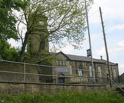
Carr Hall Castle
Carr Hall Castle, located on the edge of Thunnerley Wood in the Holywell Brook valley, was built in the mid nineteenth century by the Shaw family, local mill owners, to improve the view from their mansion at Shaw Park. It provided a stable block and housing for the bailiff who bred the shire horses for Brookroyd Mills. The building has been restored and modernised since 2002. In 2008 the castle won Channel Five's TV show I Own Britain's Best Home, and it is now available for hire.Religion
Holywell Green
Holywell Green is a small village in Calderdale, West Yorkshire, England. It is south of Halifax, north-west of Huddersfield and south-west of Elland.-History:...
and Sowood
Sowood, West Yorkshire
Sowood is a village in Calderdale, West Yorkshire, England. It is south of Halifax, north-west of Huddersfield and south-west of Elland.-Geography:...
. The church tower is visible from Norland
Norland, West Yorkshire
Norland is a scattered village to the south of Sowerby Bridge in the metropolitan borough of Calderdale in West Yorkshire, England.-History:...
and Blackley.
Stainland had three other chapels, Stainland Providence Chapel, Stainland Wesleyan Chapel and a mortuary chapel. The mortuary chapel was next to a graveyard that served the Providence Chapel. All three graveyards remain but only the Providence Chapel remains and was converted into nine houses. The mortuary chapel was demolished after the Providence Chapel became houses. The Wesleyan Chapel was demolished to make way for houses.
Pubs and restaurants
Stainland has many public houses and restaurants, one of which, '1885 The Restaurant', was awarded Yorkshire Life Neighbourhood Restaurant of the Year 2005–06, Highlife Magazine Fine Dining Restaurant of West Yorkshire 2003–04 and nominated for Yorkshire Life Newcomer Restaurant of the Year 2003–04. Other pubs include The Duke of York, The Red Lion and The Rose and Crown. The Bull and Dog (also known as The Stone Ridge) closed in 2008. The Black Horse Inn was demolished and replaced by a garage and more recently housing.Sport
Stainland has five sports clubs; Stainland United FC, Stainland Stags ARLFC, Stainland CC, Stainland Lions Running Club and Stainland Bowling Club. All are based at Stainland Recreation Ground except for Stainland Lions who are based at Heath RUFC, Greetland.Stainland Recreation Ground (Stainland Rec or the Rec) lies west of the village centre and has two football pitches, a rugby pitch, a cricket ground, a bowling green, a tennis court, a five-a-side pitch, and a playground.
Stainland United FC play in the Halifax and District League First Division
Halifax and District League
The Halifax and District Association Football League is a football competition based in England. It has a total of four divisions, of which the highest, the Premier Division, sits at level 14 of the English football league system...
. The club was formed in 1947 as Stainland Athletic and changed its name to Stainland United in 1980. In 1992 the club folded but reformed in 1997 and won the Halifax Premier Division in the 2006-07 season.
Pennine League
The Pennine Amateur Rugby League, or Pennine League is a rugby league competition for amateur open-age clubs that runs from September to April. The clubs are drawn from West Yorkshire, North Yorkshire, South Yorkshire and the east of Lancashire....
.
Stainland Cricket Club and Stainland Bowling Club share a pavilion at Stainland Recreational Ground. The pavilion was built in 2001 after the previous pavilion burnt down. The ground is called the Memorial Ground after it was given as a post-war gift in 1922. It is one of the biggest in the Halifax League. The played at Drury Lane for 40 years,. Stainland CC play in the Towergate Halifax Cricket League Second Division. Stainland won the Second Division title in 1979 and 2002.