
Staines Rural District
Encyclopedia
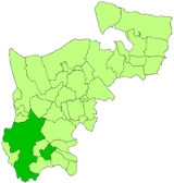
Staines was a rural district
of Middlesex
in England
from 1894 to 1930.
It was created in 1894 based on the former Staines rural sanitary district. It included the following parishes
It was named after Staines
, which bordered it to the west, and surrounded Sunbury on Thames on two sides. Feltham became an independent urban district
in 1904 and the parish of Hanworth constituted an exclave.
The district was abolished in 1930. The parishes of Ashford, Laleham and Stanwell became part of an expanded Staines Urban District
, and the parishes of Littleton and Shepperton became part of Sunbury-on-Thames Urban District
. East Bedford and Hanworth became part of the Feltham Urban District
. Cranford and Harlington became part of a Hayes and Harlington Urban District
, and Harmondsworth joined the Yiewsley and West Drayton Urban District
.
The area now forms part of the Surrey
borough of Spelthorne
(Sunbury and Staines etc), and in Greater London
the London Borough of Hounslow
(Feltham, Cranford, Bedfont, Hanworth etc), the London Borough of Hillingdon
(Harlington and Harmondsworth).
Rural district
Rural districts were a type of local government area – now superseded – established at the end of the 19th century in England, Wales, and Ireland for the administration of predominantly rural areas at a level lower than that of the administrative counties.-England and Wales:In England...
of Middlesex
Middlesex
Middlesex is one of the historic counties of England and the second smallest by area. The low-lying county contained the wealthy and politically independent City of London on its southern boundary and was dominated by it from a very early time...
in England
England
England is a country that is part of the United Kingdom. It shares land borders with Scotland to the north and Wales to the west; the Irish Sea is to the north west, the Celtic Sea to the south west, with the North Sea to the east and the English Channel to the south separating it from continental...
from 1894 to 1930.
It was created in 1894 based on the former Staines rural sanitary district. It included the following parishes
- AshfordAshford, SurreyAshford is a town almost entirely in the Surrey borough of Spelthorne in England, with a small part falling within Greater London. It is a suburban development situated 15 miles west south-west of Charing Cross in London and forms part of the London commuter belt...
- CranfordCranford, LondonCranford is a place in the London Borough of Hounslow. It is a suburban development located 12.4 miles west of Charing Cross and on the eastern perimeter of London Heathrow Airport....
- East BedfontEast BedfontBedfont is a small suburban town in Greater London, some to the west of central London and only from Heathrow Airport. It straddles the Staines Road at the west of the London Borough of Hounslow from Baber Bridge on the River Crane to the Surrey boundary at Ashford.-Origins and Mediaeval...
- FelthamFelthamFeltham is a town in the London Borough of Hounslow, west London. It is located about west south west of central London at Charing Cross and from Heathrow Airport Central...
- HanworthHanworthHanworth lies to the south east of Feltham in the London Borough of Hounslow. The name is thought to come from the Anglo Saxon words “haen” and “worth”, meaning “small homestead”....
- HarlingtonHarlington, LondonHarlington is a suburban area in the London Borough of Hillingdon, on the northern perimeter of London Heathrow Airport. It is situated west of Charing Cross.-Etymology:...
- HarmondsworthHarmondsworthHarmondsworth is a village in the London Borough of Hillingdon, close to London Heathrow Airport. The village is situated south of West Drayton.The nearest places are: Hayes, Harlington, Heathrow Airport, Longford, London, Sipson, West Drayton and Yiewsley....
- LalehamLalehamLaleham is a village in the borough of Spelthorne, in the county of Surrey in South East England and adjoins Staines. It is within the historic boundaries of Middlesex. To its south is Laleham Park by the River Thames, across green belt farmland to its north and south east are Ashford and...
- LittletonLittleton, SpelthorneLittleton is a village in Surrey in the borough of Spelthorne, in the United Kingdom. It lies between Shepperton Green to the southeast and Laleham to the west. It also lies along the southern edge of the Queen Mary Reservoir.Littleton is the home of Shepperton Studios. Littleton was home to the...
- SheppertonSheppertonShepperton is a town in the borough of Spelthorne, Surrey, England. To the south it is bounded by the river Thames at Desborough Island and is bisected by the M3 motorway...
- StanwellStanwellStanwell is a suburban village in the Surrey borough of Spelthorne. It is located 15.7 miles west south-west of Charing Cross and half a mile from the southern boundary of London Heathrow Airport and the London Borough of Hillingdon...
- HanworthHanworthHanworth lies to the south east of Feltham in the London Borough of Hounslow. The name is thought to come from the Anglo Saxon words “haen” and “worth”, meaning “small homestead”....
- Bedfont
It was named after Staines
Staines
Staines is a Thames-side town in the Spelthorne borough of Surrey and Greater London Urban Area, as well as the London Commuter Belt of South East England. It is a suburban development within the western bounds of the M25 motorway and located 17 miles west south-west of Charing Cross in...
, which bordered it to the west, and surrounded Sunbury on Thames on two sides. Feltham became an independent urban district
Urban district
In the England, Wales and Ireland, an urban district was a type of local government district that covered an urbanised area. Urban districts had an elected Urban District Council , which shared local government responsibilities with a county council....
in 1904 and the parish of Hanworth constituted an exclave.
The district was abolished in 1930. The parishes of Ashford, Laleham and Stanwell became part of an expanded Staines Urban District
Staines Urban District
Staines was a local government district from 1894 to 1974 around the town of Staines. Apart from Staines itself, it also covered Ashford, Laleham and Stanwell....
, and the parishes of Littleton and Shepperton became part of Sunbury-on-Thames Urban District
Sunbury-on-Thames Urban District
Sunbury on Thames - also known as Sunbury - was a local government district from 1894 to 1974 around the town of Sunbury-on-Thames, also covering Littleton and Shepperton....
. East Bedford and Hanworth became part of the Feltham Urban District
Feltham Urban District
Feltham was an urban district in Middlesex, England from 1904 to 1965.It was based on the parish of Feltham, which had previously been part of the Staines Rural District...
. Cranford and Harlington became part of a Hayes and Harlington Urban District
Hayes and Harlington Urban District
Hayes was a local government district in west Middlesex, England from 1904 to 1965.It was originally created in 1904 as an urban district, Hayes Urban District, covering the Hayes parish transferred from Uxbridge Rural District...
, and Harmondsworth joined the Yiewsley and West Drayton Urban District
Yiewsley and West Drayton Urban District
Yiewsley and West Drayton was an urban district in Middlesex, England.It was formed in 1911 from the parish of Yiewsley, formerly part of Uxbridge Rural District. This rural district was abolished in 1929, and Yiewsley was joined by the parish of West Drayton, resulting in a change of name for the...
.
The area now forms part of the Surrey
Surrey
Surrey is a county in the South East of England and is one of the Home Counties. The county borders Greater London, Kent, East Sussex, West Sussex, Hampshire and Berkshire. The historic county town is Guildford. Surrey County Council sits at Kingston upon Thames, although this has been part of...
borough of Spelthorne
Spelthorne
Spelthorne is a local government district and borough in Surrey, England. It includes the towns of Ashford, Laleham, Shepperton, Staines, Stanwell and Sunbury...
(Sunbury and Staines etc), and in Greater London
Greater London
Greater London is the top-level administrative division of England covering London. It was created in 1965 and spans the City of London, including Middle Temple and Inner Temple, and the 32 London boroughs. This territory is coterminate with the London Government Office Region and the London...
the London Borough of Hounslow
London Borough of Hounslow
-Political composition:Since the borough was formed it has been controlled by the Labour Party on all but two occasions. In 1968 the Conservatives formed a majority for the first and last time to date until they lost control to Labour in 1971. Labour subsequently lost control of the council in the...
(Feltham, Cranford, Bedfont, Hanworth etc), the London Borough of Hillingdon
London Borough of Hillingdon
The London Borough of Hillingdon is the westernmost borough in Greater London, England. The borough's population was recorded as 243,006 in the 2001 Census. The borough incorporates the former districts of Ruislip-Northwood, Uxbridge, Hayes and Harlington and Yiewsley and West Drayton in the...
(Harlington and Harmondsworth).