

St Giles, London
Encyclopedia
St Giles is a district of London
, England. It is the location of the church of St Giles in the Fields
, the Phoenix Garden
and St Giles Circus. (Nearest tube, Tottenham Court Road.) It is located at the southern tip of the London Borough of Camden
and is part of the Midtown business improvement district
.The combined parishes of St Giles in the Fields and St George Bloomsbury
formed the St Giles District of the Metropolis from 1855 to 1900.
, recorded c. 1120 as Hospitali Sancti Egidii extra Londonium was founded, together with a monastery and a chapel, by Queen Matilda, wife of Henry I
. St Giles (c. 650 – c. 710) was the patron saint of lepers and the hospital was home to a leper colony, the site chosen for its surrounding fields and marshes separating contagion from nearby London. Peter Ackroyd
argues that the character of vagrancy has never left the area. A village accreted to cater to the brethren and patients. The crossroads which is now St. Giles Circus, where Oxford Street, Charing Cross Road, Tottenham Court Road and New Oxford St meet, was the site of a gallows until the fifteenth century. Grape Street, in the heart of the St Giles district, runs beside the site of the hospital's vineyard.
The monastery was dissolved during the Reformation and a parish church created from the chapel. The hospital continued to care for lepers until the mid sixteenth century (when the disease abated) and instead began to care for indigents. The parish was known as St Giles in the Fields and it is recorded in 1563 as Seynt Gyles in the Field. The first post-Catholic parish church was built in 1631 and from the mid-seventeeth century church wardens note "a great influx of poor people into this parish". The cellars in particular are already recorded as horrific places that whole families reside, "damp and unwholesome" as the village was built on marshland. The Parliamentary Act of 1606 had condemned the area as "deepe foul and dangerous" . Vagrants expelled from the city settled in the St Giles district known for the generous charitable relief of the parish. Irish and French refugees were drawn to the area as well as "St Giles blackbirds", black servants reduced to begging.
The 1665 Great Plague
started in St Giles and the first victims were buried in the St. Giles churchyard. By September 1665, 8000 people were dying a week in London. By the end of the plague year there were 3,216 listed plague deaths in St Giles parish, which had fewer than 2,000 households. After the Restoration, the area was populated by Huguenot
refugees who had fled persecution and established themselves as tradesmen and artisans, particularly in weaving and the silk trade. Thornbury, Walter (1878) "Old and New London: Volume 3" pp. 197-218. " XXVI. St Giles in the Fields"
The southern area of the parish, around present day Shaftesbury Avenue, was a wasteland named Cock and Pye Fields. Houses were not built there until 1666, after the Great Fire, and not fully developed until 1693, becoming known as Seven Dials
. Thomas Neale
built much of the area, giving his name to Neal Street and Neal's Yard
. St Giles and Seven Dials became known for their astrologers and alchemists, an association which lasts to this day. The village of St Giles stood on the main road from Holborn
to Tyburn
, a place of local execution. Convicted criminals were often allowed, in tradition, to stop at St Giles en route to Tyburn for a final drink - a "St Giles Bowl" - before hanging.
 As London grew in the 18th and 19th centuries, so did the parish's population, rising to 30,000 by 1831. The Rookery
stood between the church and Great Russell Street
, and Seven Dials
near where Centre Point
stands today, now home to the Centrepoint homeless charity
.Guardian article "London parish's descent from glamour to grime charted in exhibition" 16 May 2011 It was of one of the worst slums within Britain a site of overcrowding and squalor, a the semi-derelict warren. From Georgian affluence in the 18th century, the area declined rapidly, as houses were divided up, many families sharing a single room. Irish Catholic immigrants seeking to escape desperate poverty took up residence and the slum was nicknamed "Little Ireland" or "The Holy Land". The expression "a St Giles cellar" passed into common parlance, describing the worst conditions of poverty. Open sewers often ran through rooms and cesspit
s were left untended. Residents complained to the Times in 1849 : "We live in muck and filth. We aint got no priviz
, no dust bins, no drains, no water-splies
, and no drain or suer
in the hole place." Letter to The Times complaining of their living conditions, written by residents of St Giles" 17 May 2011 The rookery was a maze of gin shops, prostitutes' hovels and secret alleyways that police had little of hope navigating. William Hogarth
, Thomas Rowlandson
and Gustav Dore, among others, have drawn the area, novelists Henry Fielding
and Charles Dickens
have written about it extensively. Peter Ackroyd
writes "The Rookeries embodied the worst living conditions in all of London's history; this was the lowest point which human beings could reach".
Reformer Henry Mayhew
described the slum in 1860 in A Visit to the Rookery of St Giles and its Neighbourhood: "The parish of St. Giles, with its nests of close and narrow alleys and courts inhabited by the lowest class of Irish costermonger
s, has passed into a byword as the synonym of filth and squalor. And although New Oxford Street has been carried straight through the middle of the worst part of its slums—"the Rookery"—yet, especially on the south side, there still are streets which demand to be swept away in the interest of health and cleanliness… They [are] a noisy and riotous lot, fond of street brawls, equally "fat, ragged and saucy;" and the courts abound in pedlars, fish-women, newscriers, and corn-cutters." As the population grew, so did their dead, the area a home to cholera and consumption. Eventually there was no room in their grave yard, so during the eighteenth and nineteenth centuries, many were buried in the cemeteries surrounding St Pancras
.
From the 1830s to the 1870s plans were developed to demolish the slum as part of London wide clearances for improved transport routes, sanitation and the expansion of the railways. New Oxford Street was driven through the area to join the areas of Oxford Street and Holborn. The Rookery dwellers were not re-housed by the authorities. 5000 were evicted and many just moved into near by slums, such Devil's Acre
and Church Lane making those more overcrowded still. The unchanging character of the area, failing investment schemes and inability to sell new properties ensured that plans for wholesale clearance were stymied until the end of the century.
hundred of Middlesex
. The parish of St George Bloomsbury
was split off in 1731, but the parishes were combined for civil purposes in 1774 and used for the administration of the Poor Law
after the Poor Law Amendment Act 1834
. Upon the creation of the Metropolitan Board of Works
in 1855 the combined parishes became the St Giles District and were transferred to the County of London
in 1889.
The St Giles civil parish was an elongated "L" shape, stretching from Torrington Place in the north to Shelton Street in the south and then east to include Lincoln's Inn Fields
. For registration
, and therefore census reporting, the ancient parish was divided in North and South districts, with Monmouth Street broadly forming the division. The length of St Giles High Street is identical to the width of the parish at that point. The parish of St George Bloomsbury was located to the northeast. In 1881 the population of St Giles North was 13,837 and St Giles South was 14,864.
The local government of London was reorganised in 1900 and St Giles became part of the Metropolitan Borough of Holborn
. Since 1965 it has been part of the London Borough of Camden
.
 The etching "Four Times of Day" by Hogarth takes place in Hog Lane, with the church of St Giles in the Fields
in the background. Hogarth would feature St Giles again as the background of Gin Lane and First Stage of Cruelty
. The picture shows the Huguenot refugees who arrived in the 1680s and established themselves in the silk trade; Hogarth contrasts their fussiness and high fashion with the slovenliness of the group on the other side of the road; the rotting corpse of a cat that has been stoned to death lying in the gutter that divides the street is the only thing the two sides have in common. The older members of the congregation wear traditional dress, while the younger members wear the fashions of the day. The children are dressed up as adults: the boy in the foreground struts around in his finery while the boy with his back to the viewer has his hair in a net, bagged up in the "French" style. At the far right, a black man, probably a freed slave, fondles the breasts of a woman, distracting her from her work, her pie-dish "tottering like her virtue". In front of the couple, a boy has set down his pie to rest, but the plate has broken, spilling the pie onto the ground where it is being rapidly consumed by an urchin.
 Set in St Giles, "Gin Lane" depicts the squalor and despair of a community raised on gin. The only businesses that flourish are those which serve the gin industry: gin sellers; distillers; the pawnbroker
where the avaricious Mr. Gripe greedily takes the vital possessions (the carpenter offers his saw and the housewife her cooking utensils) of the alcoholic residents of the street in return for a few pennies to feed their habit; and the undertaker, for whom Hogarth implies at least a handful of new customers from this scene alone. Most shockingly, the focus of the picture is a woman in the foreground, who, addled by gin and driven to prostitution by her habit —as evidenced by the syphilitic sores on her legs— lets her baby slip unheeded from her arms and plunge to its death in the stairwell of the gin cellar below. Half-naked, she has no concern for anything other than a pinch of snuff. This mother was not such an exaggeration as she might appear: in 1734, Judith Dufour reclaimed her two-year-old child from the workhouse
where it had been given a new set of clothes; she then strangled it and left the infant's body in a ditch so that she could sell the clothes (for 1s. 4d.) to buy gin. In another case, an elderly woman, Mary Estwick, let a toddler burn to death while she slept in a gin-induced stupor. Other images of despair and madness fill the scene: a lunatic cavorts in the street beating himself over the head with a pair of bellows while holding a baby impaled on a spike—the dead child's frantic mother rushes from the house screaming in horror; a barber has taken his own life in the dilapidated attic of his barber-shop, ruined because nobody can afford a haircut or shave; on the steps, below the woman who has let her baby fall, a skeletal pamphlet-seller rests, perhaps dead of starvation, as the unsold moralising pamphlet on the evils of gin-drinking, The Downfall of Mrs Gin, slips from his basket.
. An initialled badge on the shoulder of his light-hued and ragged coat shows him to be a pupil of the charity school
of the parish of St Giles. A more tender-hearted boy, perhaps the dog's owner, pleads with Nero to stop tormenting the frightened animal, even offering food in an attempt to appease him.
and Holborn and Covent Garden in the London Borough of Camden. With some sections of Holborn
and Bloomsbury
it forms part of the Midtown business improvement district
. It is within the Holborn and St Pancras Parliament constituency and the Barnet and Camden
London Assembly constituency. For elections to the European Parliament it is part of the London
constituency.
(CLR) opened Tottenham Court Tube Station, between St Giles church and St Giles Circus on 30 July 1900. Tottenham Court Road underwent improvements in the early 1930s to replace lifts with escalators. The station had four entrances to the sub-surface ticket hall from the north-east, south-west and north-west corners of St Giles Circus and from a subway beneath the Centrepoint building which starts on Andrew Borde Street. The entrances were frequently congested leading to occasions during peak periods of the day when they were briefly closed to prevent overcrowding in the station.
In 2009, Transport for London
began a major reconstruction of large parts of the station. Much of the St Giles area alongside St Giles High Street has been cleared to make way for the new development including Crossrail
expansion. The Astoria
theatre on Charing Cross Road has been demolished and the original Central line entrances will also go.
London
London is the capital city of :England and the :United Kingdom, the largest metropolitan area in the United Kingdom, and the largest urban zone in the European Union by most measures. Located on the River Thames, London has been a major settlement for two millennia, its history going back to its...
, England. It is the location of the church of St Giles in the Fields
St Giles in the Fields
St Giles in the Fields, Holborn, is a church in the London Borough of Camden, in the West End. It is close to the Centre Point office tower and the Tottenham Court Road tube station. The church is part of the Diocese of London within the Church of England...
, the Phoenix Garden
Phoenix Garden
The Phoenix Garden is a local community garden in central London, England, established in 1984.Located in St Giles behind the Phoenix Theatre, within the London Borough of Camden, the Phoenix Garden is nestled between the busy Soho and Covent Garden areas...
and St Giles Circus. (Nearest tube, Tottenham Court Road.) It is located at the southern tip of the London Borough of Camden
London Borough of Camden
In 1801, the civil parishes that form the modern borough were already developed and had a total population of 96,795. This continued to rise swiftly throughout the 19th century, as the district became built up; reaching 270,197 in the middle of the century...
and is part of the Midtown business improvement district
Business improvement district
A business improvement district is a defined area within which businesses pay an additional tax or fee in order to fund improvements within the district's boundaries. Grant funds acquired by the city for special programs and/or incentives such as tax abatements can be made available to assist...
.The combined parishes of St Giles in the Fields and St George Bloomsbury
Bloomsbury
-Places:* Bloomsbury is an area in central London.* Bloomsbury , related local government unit* Bloomsbury, New Jersey, New Jersey, USA* Bloomsbury , listed on the NRHP in Maryland...
formed the St Giles District of the Metropolis from 1855 to 1900.
History
There has been a church at St Giles since Saxon times, located beside a major highway. London: A Biography (2000) Ackroyd, Peter Chatto and Windus p131-140The hospital of St GilesSt Giles in the Fields
St Giles in the Fields, Holborn, is a church in the London Borough of Camden, in the West End. It is close to the Centre Point office tower and the Tottenham Court Road tube station. The church is part of the Diocese of London within the Church of England...
, recorded c. 1120 as Hospitali Sancti Egidii extra Londonium was founded, together with a monastery and a chapel, by Queen Matilda, wife of Henry I
Henry I
Henry I may refer to:* Henry I the Fowler, King of Germany * Henry I, Duke of Bavaria * Henry I of Austria, Margrave of Austria * Henry I of France * Henry I, Margrave of the Saxon Ostmark...
. St Giles (c. 650 – c. 710) was the patron saint of lepers and the hospital was home to a leper colony, the site chosen for its surrounding fields and marshes separating contagion from nearby London. Peter Ackroyd
Peter Ackroyd
Peter Ackroyd CBE is an English biographer, novelist and critic with a particular interest in the history and culture of London. For his novels about English history and culture and his biographies of, among others, Charles Dickens, T. S. Eliot and Sir Thomas More he won the Somerset Maugham Award...
argues that the character of vagrancy has never left the area. A village accreted to cater to the brethren and patients. The crossroads which is now St. Giles Circus, where Oxford Street, Charing Cross Road, Tottenham Court Road and New Oxford St meet, was the site of a gallows until the fifteenth century. Grape Street, in the heart of the St Giles district, runs beside the site of the hospital's vineyard.
The monastery was dissolved during the Reformation and a parish church created from the chapel. The hospital continued to care for lepers until the mid sixteenth century (when the disease abated) and instead began to care for indigents. The parish was known as St Giles in the Fields and it is recorded in 1563 as Seynt Gyles in the Field. The first post-Catholic parish church was built in 1631 and from the mid-seventeeth century church wardens note "a great influx of poor people into this parish". The cellars in particular are already recorded as horrific places that whole families reside, "damp and unwholesome" as the village was built on marshland. The Parliamentary Act of 1606 had condemned the area as "deepe foul and dangerous" . Vagrants expelled from the city settled in the St Giles district known for the generous charitable relief of the parish. Irish and French refugees were drawn to the area as well as "St Giles blackbirds", black servants reduced to begging.
The 1665 Great Plague
Great Plague of London
The Great Plague was a massive outbreak of disease in the Kingdom of England that killed an estimated 100,000 people, 20% of London's population. The disease is identified as bubonic plague, an infection by the bacterium Yersinia pestis, transmitted through a flea vector...
started in St Giles and the first victims were buried in the St. Giles churchyard. By September 1665, 8000 people were dying a week in London. By the end of the plague year there were 3,216 listed plague deaths in St Giles parish, which had fewer than 2,000 households. After the Restoration, the area was populated by Huguenot
Huguenot
The Huguenots were members of the Protestant Reformed Church of France during the 16th and 17th centuries. Since the 17th century, people who formerly would have been called Huguenots have instead simply been called French Protestants, a title suggested by their German co-religionists, the...
refugees who had fled persecution and established themselves as tradesmen and artisans, particularly in weaving and the silk trade. Thornbury, Walter (1878) "Old and New London: Volume 3" pp. 197-218. " XXVI. St Giles in the Fields"
The southern area of the parish, around present day Shaftesbury Avenue, was a wasteland named Cock and Pye Fields. Houses were not built there until 1666, after the Great Fire, and not fully developed until 1693, becoming known as Seven Dials
Seven Dials
Seven Dials is a small but well-known road junction in the West End of London in Covent Garden where seven streets converge. At the centre of the roughly-circular space is a pillar bearing six sundials, a result of the pillar being commissioned before a late stage alteration of the plans from an...
. Thomas Neale
Thomas Neale
Thomas Neale was a British project-manager and politician who was also well-known in the United States as the first person to hold a position equivalent to postmaster-general of the North American colonies....
built much of the area, giving his name to Neal Street and Neal's Yard
Neal's Yard
Neal's Yard is a small alley in Covent Garden between Shorts Gardens and Monmouth Street which opens into a courtyard. It is named after the 17th century developer, Thomas Neale. It now contains several health food cafes and new age retailers such as Neal's Yard Remedies, Neal's Yard Dairy, World...
. St Giles and Seven Dials became known for their astrologers and alchemists, an association which lasts to this day. The village of St Giles stood on the main road from Holborn
Holborn
Holborn is an area of Central London. Holborn is also the name of the area's principal east-west street, running as High Holborn from St Giles's High Street to Gray's Inn Road and then on to Holborn Viaduct...
to Tyburn
Tyburn
Tyburn is a former village just outside the then boundaries of London that was best known as a place of public execution.Tyburn may also refer to:* Tyburn , river and historical water source in London...
, a place of local execution. Convicted criminals were often allowed, in tradition, to stop at St Giles en route to Tyburn for a final drink - a "St Giles Bowl" - before hanging.
The rookery
Rookery (slum)
A rookery was the colloquial British English term given in the 18th and 19th centuries to a city slum occupied by poor people...
stood between the church and Great Russell Street
Great Russell Street
Great Russell Street is a street in Bloomsbury, central London, England. It is the location of the main entrance of the British Museum to the north. The Congress Centre of the Trades Union Congress is located at number 28...
, and Seven Dials
Seven Dials
Seven Dials is a small but well-known road junction in the West End of London in Covent Garden where seven streets converge. At the centre of the roughly-circular space is a pillar bearing six sundials, a result of the pillar being commissioned before a late stage alteration of the plans from an...
near where Centre Point
Centre Point
Centre Point is a substantial concrete and glass office building in central London, England, occupying 101-103 New Oxford Street, WC1, close to St Giles Circus and almost directly above Tottenham Court Road tube station. The site was once occupied by a gallows...
stands today, now home to the Centrepoint homeless charity
Centrepoint (charity)
Centrepoint is the leading charity in the United Kingdom supporting homeless young people aged 16-25. Its is HRH The Duke of Cambridge.It provides a range of accommodation and additional support in health, education and life skills...
.Guardian article "London parish's descent from glamour to grime charted in exhibition" 16 May 2011 It was of one of the worst slums within Britain a site of overcrowding and squalor, a the semi-derelict warren. From Georgian affluence in the 18th century, the area declined rapidly, as houses were divided up, many families sharing a single room. Irish Catholic immigrants seeking to escape desperate poverty took up residence and the slum was nicknamed "Little Ireland" or "The Holy Land". The expression "a St Giles cellar" passed into common parlance, describing the worst conditions of poverty. Open sewers often ran through rooms and cesspit
Cesspit
A cesspit, or cesspool is a pit, conservancy tank, or covered cistern, which can be used to dispose of urine and feces, and more generally of all sewage and refuse. It is a more antiquated solution than a sewer system. Traditionally, it was a deep cylindrical chamber dug into the earth, having...
s were left untended. Residents complained to the Times in 1849 : "We live in muck and filth. We aint got no priviz
Toilet
A toilet is a sanitation fixture used primarily for the disposal of human excrement, often found in a small room referred to as a toilet/bathroom/lavatory...
, no dust bins, no drains, no water-splies
Water supply
Water supply is the provision of water by public utilities, commercial organisations, community endeavours or by individuals, usually via a system of pumps and pipes...
, and no drain or suer
Sewer
Sewer may refer to:* Part of sewerage, the infrastructure that conveys sewage*Effluent sewer, a collection system that transports only the liquid portion of wastewater through small-diameter pipes laid at contour...
in the hole place." Letter to The Times complaining of their living conditions, written by residents of St Giles" 17 May 2011 The rookery was a maze of gin shops, prostitutes' hovels and secret alleyways that police had little of hope navigating. William Hogarth
William Hogarth
William Hogarth was an English painter, printmaker, pictorial satirist, social critic and editorial cartoonist who has been credited with pioneering western sequential art. His work ranged from realistic portraiture to comic strip-like series of pictures called "modern moral subjects"...
, Thomas Rowlandson
Thomas Rowlandson
Thomas Rowlandson was an English artist and caricaturist.- Biography :Rowlandson was born in Old Jewry, in the City of London. He was the son of a tradesman or city merchant. On leaving school he became a student at the Royal Academy...
and Gustav Dore, among others, have drawn the area, novelists Henry Fielding
Henry Fielding
Henry Fielding was an English novelist and dramatist known for his rich earthy humour and satirical prowess, and as the author of the novel Tom Jones....
and Charles Dickens
Charles Dickens
Charles John Huffam Dickens was an English novelist, generally considered the greatest of the Victorian period. Dickens enjoyed a wider popularity and fame than had any previous author during his lifetime, and he remains popular, having been responsible for some of English literature's most iconic...
have written about it extensively. Peter Ackroyd
Peter Ackroyd
Peter Ackroyd CBE is an English biographer, novelist and critic with a particular interest in the history and culture of London. For his novels about English history and culture and his biographies of, among others, Charles Dickens, T. S. Eliot and Sir Thomas More he won the Somerset Maugham Award...
writes "The Rookeries embodied the worst living conditions in all of London's history; this was the lowest point which human beings could reach".
Reformer Henry Mayhew
Henry Mayhew
Henry Mayhew was an English social researcher, journalist, playwright and advocate of reform. He was one of the two founders of the satirical and humorous magazine Punch, and the magazine's joint-editor, with Mark Lemon, in its early days...
described the slum in 1860 in A Visit to the Rookery of St Giles and its Neighbourhood: "The parish of St. Giles, with its nests of close and narrow alleys and courts inhabited by the lowest class of Irish costermonger
Costermonger
Costermonger, or simply Coster, is a street seller of fruit and vegetables, in London and other British towns. They were ubiquitous in mid-Victorian England, and some are still found in markets. As usual with street-sellers, they would use a loud sing-song cry or chant to attract attention...
s, has passed into a byword as the synonym of filth and squalor. And although New Oxford Street has been carried straight through the middle of the worst part of its slums—"the Rookery"—yet, especially on the south side, there still are streets which demand to be swept away in the interest of health and cleanliness… They [are] a noisy and riotous lot, fond of street brawls, equally "fat, ragged and saucy;" and the courts abound in pedlars, fish-women, newscriers, and corn-cutters." As the population grew, so did their dead, the area a home to cholera and consumption. Eventually there was no room in their grave yard, so during the eighteenth and nineteenth centuries, many were buried in the cemeteries surrounding St Pancras
St Pancras, London
St Pancras is an area of London. For many centuries the name has been used for various officially-designated areas, but now is used informally and rarely having been largely superseded by several other names for overlapping districts.-Ancient parish:...
.
From the 1830s to the 1870s plans were developed to demolish the slum as part of London wide clearances for improved transport routes, sanitation and the expansion of the railways. New Oxford Street was driven through the area to join the areas of Oxford Street and Holborn. The Rookery dwellers were not re-housed by the authorities. 5000 were evicted and many just moved into near by slums, such Devil's Acre
Devil's Acre
The Devil's Acre was a notorious slum near Westminster Abbey in Victorian London. The Devil's Acre was located along Old Pye Street, Great St Anne's Lane and Duck Lane in the parish of Westminster St Margaret and St John.In the 19th century it was considered one of the worst areas of London and...
and Church Lane making those more overcrowded still. The unchanging character of the area, failing investment schemes and inability to sell new properties ensured that plans for wholesale clearance were stymied until the end of the century.
Local governance
The ancient parish of St Giles in the Fields formed part of the OssulstoneOssulstone
Ossulstone was an ancient hundred in the south east of the county of Middlesex, England. Its area has been entirely absorbed by the growth of London; and now corresponds to the part of Inner London that is north of the River Thames and, from Outer London, parts of the London boroughs of Barnet,...
hundred of Middlesex
Middlesex
Middlesex is one of the historic counties of England and the second smallest by area. The low-lying county contained the wealthy and politically independent City of London on its southern boundary and was dominated by it from a very early time...
. The parish of St George Bloomsbury
Bloomsbury
-Places:* Bloomsbury is an area in central London.* Bloomsbury , related local government unit* Bloomsbury, New Jersey, New Jersey, USA* Bloomsbury , listed on the NRHP in Maryland...
was split off in 1731, but the parishes were combined for civil purposes in 1774 and used for the administration of the Poor Law
Poor Law
The English Poor Laws were a system of poor relief which existed in England and Wales that developed out of late-medieval and Tudor-era laws before being codified in 1587–98...
after the Poor Law Amendment Act 1834
Poor Law Amendment Act 1834
The Poor Law Amendment Act 1834, sometimes abbreviated to PLAA, was an Act of the Parliament of the United Kingdom passed by the Whig government of Lord Melbourne that reformed the country's poverty relief system . It was an Amendment Act that completely replaced earlier legislation based on the...
. Upon the creation of the Metropolitan Board of Works
Metropolitan Board of Works
The Metropolitan Board of Works was the principal instrument of London-wide government from 1855 until the establishment of the London County Council in 1889. Its principal responsibility was to provide infrastructure to cope with London's rapid growth, which it successfully accomplished. The MBW...
in 1855 the combined parishes became the St Giles District and were transferred to the County of London
County of London
The County of London was a county of England from 1889 to 1965, corresponding to the area known today as Inner London. It was created as part of the general introduction of elected county government in England, by way of the Local Government Act 1888. The Act created an administrative County of...
in 1889.
The St Giles civil parish was an elongated "L" shape, stretching from Torrington Place in the north to Shelton Street in the south and then east to include Lincoln's Inn Fields
Lincoln's Inn Fields
Lincoln's Inn Fields is the largest public square in London, UK. It was laid out in the 1630s under the initiative of the speculative builder and contractor William Newton, "the first in a long series of entrepreneurs who took a hand in developing London", as Sir Nikolaus Pevsner observes...
. For registration
Registration district
A registration district in the United Kingdom is a type of administrative region which exists for the purpose of civil registration of births, marriages, and deaths and civil partnerships...
, and therefore census reporting, the ancient parish was divided in North and South districts, with Monmouth Street broadly forming the division. The length of St Giles High Street is identical to the width of the parish at that point. The parish of St George Bloomsbury was located to the northeast. In 1881 the population of St Giles North was 13,837 and St Giles South was 14,864.
The local government of London was reorganised in 1900 and St Giles became part of the Metropolitan Borough of Holborn
Metropolitan Borough of Holborn
The Metropolitan Borough of Holborn was a Metropolitan borough in the County of London between 1900 and 1965, when it was amalgamated with the Metropolitan Borough of St Pancras and the Metropolitan Borough of Hampstead to form the London Borough of Camden....
. Since 1965 it has been part of the London Borough of Camden
London Borough of Camden
In 1801, the civil parishes that form the modern borough were already developed and had a total population of 96,795. This continued to rise swiftly throughout the 19th century, as the district became built up; reaching 270,197 in the middle of the century...
.
"Four Times of Day"
St Giles in the Fields
St Giles in the Fields, Holborn, is a church in the London Borough of Camden, in the West End. It is close to the Centre Point office tower and the Tottenham Court Road tube station. The church is part of the Diocese of London within the Church of England...
in the background. Hogarth would feature St Giles again as the background of Gin Lane and First Stage of Cruelty
The Four Stages of Cruelty
The Four Stages of Cruelty is a series of four printed engravings published by English artist William Hogarth in 1751. Each print depicts a different stage in the life of the fictional Tom Nero....
. The picture shows the Huguenot refugees who arrived in the 1680s and established themselves in the silk trade; Hogarth contrasts their fussiness and high fashion with the slovenliness of the group on the other side of the road; the rotting corpse of a cat that has been stoned to death lying in the gutter that divides the street is the only thing the two sides have in common. The older members of the congregation wear traditional dress, while the younger members wear the fashions of the day. The children are dressed up as adults: the boy in the foreground struts around in his finery while the boy with his back to the viewer has his hair in a net, bagged up in the "French" style. At the far right, a black man, probably a freed slave, fondles the breasts of a woman, distracting her from her work, her pie-dish "tottering like her virtue". In front of the couple, a boy has set down his pie to rest, but the plate has broken, spilling the pie onto the ground where it is being rapidly consumed by an urchin.
"Gin Lane"
Pawnbroker
A pawnbroker is an individual or business that offers secured loans to people, with items of personal property used as collateral...
where the avaricious Mr. Gripe greedily takes the vital possessions (the carpenter offers his saw and the housewife her cooking utensils) of the alcoholic residents of the street in return for a few pennies to feed their habit; and the undertaker, for whom Hogarth implies at least a handful of new customers from this scene alone. Most shockingly, the focus of the picture is a woman in the foreground, who, addled by gin and driven to prostitution by her habit —as evidenced by the syphilitic sores on her legs— lets her baby slip unheeded from her arms and plunge to its death in the stairwell of the gin cellar below. Half-naked, she has no concern for anything other than a pinch of snuff. This mother was not such an exaggeration as she might appear: in 1734, Judith Dufour reclaimed her two-year-old child from the workhouse
Workhouse
In England and Wales a workhouse, colloquially known as a spike, was a place where those unable to support themselves were offered accommodation and employment...
where it had been given a new set of clothes; she then strangled it and left the infant's body in a ditch so that she could sell the clothes (for 1s. 4d.) to buy gin. In another case, an elderly woman, Mary Estwick, let a toddler burn to death while she slept in a gin-induced stupor. Other images of despair and madness fill the scene: a lunatic cavorts in the street beating himself over the head with a pair of bellows while holding a baby impaled on a spike—the dead child's frantic mother rushes from the house screaming in horror; a barber has taken his own life in the dilapidated attic of his barber-shop, ruined because nobody can afford a haircut or shave; on the steps, below the woman who has let her baby fall, a skeletal pamphlet-seller rests, perhaps dead of starvation, as the unsold moralising pamphlet on the evils of gin-drinking, The Downfall of Mrs Gin, slips from his basket.
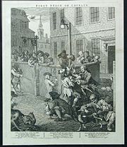
"First stage of cruelty"
Set in St Giles, the etching shows a boy, Nero, is being assisted by other boys torturing a dog by inserting an arrow into a its rectumRectum
The rectum is the final straight portion of the large intestine in some mammals, and the gut in others, terminating in the anus. The human rectum is about 12 cm long...
. An initialled badge on the shoulder of his light-hued and ragged coat shows him to be a pupil of the charity school
Charity school
A charity school, also called Blue Coat School, was significant in the History of education in England. They were erected and maintained in various parishes, by the voluntary contributions of the inhabitants, for teaching poor children to read, write, and other necessary parts of education...
of the parish of St Giles. A more tender-hearted boy, perhaps the dog's owner, pleads with Nero to stop tormenting the frightened animal, even offering food in an attempt to appease him.
Modern governance
St Giles is split between the electoral wards of BloomsburyBloomsbury (ward)
- External links :* * * *...
and Holborn and Covent Garden in the London Borough of Camden. With some sections of Holborn
Holborn
Holborn is an area of Central London. Holborn is also the name of the area's principal east-west street, running as High Holborn from St Giles's High Street to Gray's Inn Road and then on to Holborn Viaduct...
and Bloomsbury
Bloomsbury
-Places:* Bloomsbury is an area in central London.* Bloomsbury , related local government unit* Bloomsbury, New Jersey, New Jersey, USA* Bloomsbury , listed on the NRHP in Maryland...
it forms part of the Midtown business improvement district
Business improvement district
A business improvement district is a defined area within which businesses pay an additional tax or fee in order to fund improvements within the district's boundaries. Grant funds acquired by the city for special programs and/or incentives such as tax abatements can be made available to assist...
. It is within the Holborn and St Pancras Parliament constituency and the Barnet and Camden
Barnet and Camden (London Assembly constituency)
Barnet and Camden is a constituency represented in the London Assembly. It has been represented since its creation in 2000 by Brian Coleman, a Conservative from Barnet....
London Assembly constituency. For elections to the European Parliament it is part of the London
London (European Parliament constituency)
London is a constituency of the European Parliament. It currently elects 8 MEPs using the d'Hondt method of party-list proportional representation.- Boundaries :The constituency corresponds to Greater London, in the south east of the United Kingdom....
constituency.
Tottenham Court Road tube station
The Central London RailwayCentral London Railway
The Central London Railway , also known as the Twopenny Tube, was a deep-level, underground "tube" railway that opened in London in 1900...
(CLR) opened Tottenham Court Tube Station, between St Giles church and St Giles Circus on 30 July 1900. Tottenham Court Road underwent improvements in the early 1930s to replace lifts with escalators. The station had four entrances to the sub-surface ticket hall from the north-east, south-west and north-west corners of St Giles Circus and from a subway beneath the Centrepoint building which starts on Andrew Borde Street. The entrances were frequently congested leading to occasions during peak periods of the day when they were briefly closed to prevent overcrowding in the station.
In 2009, Transport for London
Transport for London
Transport for London is the local government body responsible for most aspects of the transport system in Greater London in England. Its role is to implement the transport strategy and to manage transport services across London...
began a major reconstruction of large parts of the station. Much of the St Giles area alongside St Giles High Street has been cleared to make way for the new development including Crossrail
Crossrail
Crossrail is a project to build a major new railway link under central London. The name refers to the first of two routes which are the responsibility of Crossrail Ltd. It is based on an entirely new east-west tunnel with a central section from to Liverpool Street station...
expansion. The Astoria
London Astoria
The London Astoria was a music venue, located at 157 Charing Cross Road, in London, England. It had been leased and run by Festival Republic since 2000. It was closed on 15 January 2009 and has since been demolished...
theatre on Charing Cross Road has been demolished and the original Central line entrances will also go.
See also
- Church of St Giles in the FieldsSt Giles in the FieldsSt Giles in the Fields, Holborn, is a church in the London Borough of Camden, in the West End. It is close to the Centre Point office tower and the Tottenham Court Road tube station. The church is part of the Diocese of London within the Church of England...
- St Giles Circus
- St Giles Metropolitan District
- Central Saint GilesCentral Saint GilesCentral Saint Giles is a mixed-use development in central London. Built at a cost of £450 million and completed in May 2010, it was designed by the Italian architect Renzo Piano and is his first work in the UK. The development consists of two buildings of up to 15 storeys in height, arranged...