

St George's Circus
Encyclopedia
Southwark
Southwark is a district of south London, England, and the administrative headquarters of the London Borough of Southwark. Situated east of Charing Cross, it forms one of the oldest parts of London and fronts the River Thames to the north...
, London
London
London is the capital city of :England and the :United Kingdom, the largest metropolitan area in the United Kingdom, and the largest urban zone in the European Union by most measures. Located on the River Thames, London has been a major settlement for two millennia, its history going back to its...
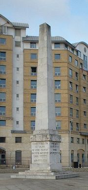
, England. At its centre, which is now a traffic roundabout
Roundabout
A roundabout is the name for a road junction in which traffic moves in one direction around a central island. The word dates from the early 20th century. Roundabouts are common in many countries around the world...
, is a historic obelisk
Obelisk
An obelisk is a tall, four-sided, narrow tapering monument which ends in a pyramid-like shape at the top, and is said to resemble a petrified ray of the sun-disk. A pair of obelisks usually stood in front of a pylon...
, designed by Robert Mylne
Robert Mylne
Robert Mylne was a Scottish architect and civil engineer, particularly remembered for his design for Blackfriars Bridge in London. Born and raised in Edinburgh, he travelled to Europe as a young man, studying architecture in Rome under Piranesi...
(1733–1811), in his role as surveyor and architect of Blackfriars Bridge
Blackfriars Bridge
Blackfriars Bridge is a road and foot traffic bridge over the River Thames in London, between Waterloo Bridge and Blackfriars Railway Bridge, carrying the A201 road. The north end is near the Inns of Court and Temple Church, along with Blackfriars station...
.
History
It was built in 1771 to mark the completion of the new roads through St George's FieldsSt George's Fields
St George's Fields was an area of Southwark in South London, England.Originally the area was an undifferentiated part of the south-side of the Thames, which was low lying marshland unsuitable for even agricultural purposes. As such it was part of the extensive holdings of the king, it is difficult...
in the parish of Southwark St George the Martyr
Southwark St George the Martyr
Southwark St George the Martyr was a civil parish in the metropolitan area of London, England and part of the ancient Borough of Southwark. In 1855 the parish vestry became a local authority within the area of responsibility of the Metropolitan Board of Works...
during the tenure of Brass Crosby
Brass Crosby
Brass Crosby was an English radical lawyer, Member of Parliament and Lord Mayor of London.-Life:Brass Crosby was born in Stockton-on-Tees in 1725. He qualified in law and came to London to practise his chosen profession. In 1758 he was elected to the City Council and elected 'lay' Sheriff in 1764...
as Lord Mayor of the City of London. In 1905, the obelisk was relocated to Geraldine Mary Harmsworth Park, in front of the Imperial War Museum
Imperial War Museum
Imperial War Museum is a British national museum organisation with branches at five locations in England, three of which are in London. The museum was founded during the First World War in 1917 and intended as a record of the war effort and sacrifice of Britain and her Empire...
close by, to accommodate a new clock tower. The clocktower was demolished as a "nuisance to traffic" in the 1930s, but the obelisk did not return to its original location until the late 1990s. At the base of the obelisk is the inscription Erected in XI year of the reign of King George
George III of the United Kingdom
George III was King of Great Britain and King of Ireland from 25 October 1760 until the union of these two countries on 1 January 1801, after which he was King of the United Kingdom of Great Britain and Ireland until his death...
MDCCLXXI, with the inscriptions on the other three sides reflecting the obelisk's one-mile distance from Palace Yard
Old Palace Yard
Old Palace Yard is immediately to the west of the Houses of Parliament in Westminster, London, England, near the eastern end of Westminster Abbey. It provides pedestrian access to the Houses of Parliament via St Stephen's Entrance. A square of grass opposite is often used by television journalists...
, London Bridge
London Bridge
London Bridge is a bridge over the River Thames, connecting the City of London and Southwark, in central London. Situated between Cannon Street Railway Bridge and Tower Bridge, it forms the western end of the Pool of London...
and Fleet Street
Fleet Street
Fleet Street is a street in central London, United Kingdom, named after the River Fleet, a stream that now flows underground. It was the home of the British press until the 1980s...
.
The landscaping introduced in the centre of the circus when the obelisk returned incorporated a semi circle of soil in which two Cabbage Palms were planted. This was then neglected and fell into long term decay until in 2005 guerrilla gardeners
Guerrilla gardening
Guerrilla gardening is gardening on another person's land without permission. It encompasses a very diverse range of people and motivations, from the enthusiastic gardener who spills over their legal boundaries to the highly political gardener who seeks to provoke change through direct action. It...
took over the land. They have since replanted it with lavender, rosemary, tulips, campanula, azalea and even a 7' Christmas tree. It is regularly cleared of litter and weeds and has becoming something of a landmark, appearing in press all over the world.
The circus and obelisk provided a formal termination of Blackfriars Road
Blackfriars Road
Blackfriars Road is a road in Southwark, SE1. It runs between St George's Circus at the southern end and Blackfriars Bridge over the River Thames at the northern end, leading to the City of London. Halfway up on the west side is Southwark tube station, on the corner with The Cut...
, a mile long boulevard from the recently constructed Blackfriars Bridge
Blackfriars Bridge
Blackfriars Bridge is a road and foot traffic bridge over the River Thames in London, between Waterloo Bridge and Blackfriars Railway Bridge, carrying the A201 road. The north end is near the Inns of Court and Temple Church, along with Blackfriars station...
. At the circus, Blackfriars Road intersected with new and existing highways to Lambeth
Lambeth
Lambeth is a district of south London, England, and part of the London Borough of Lambeth. It is situated southeast of Charing Cross.-Toponymy:...
, Newington
Newington, London
Newington is a district of London, England, and part of the London Borough of Southwark. It was an ancient parish and the site of the early administration of the county of Surrey...
, Westminster Bridge
Westminster Bridge
Westminster Bridge is a road and foot traffic bridge over the River Thames between Westminster on the north side and Lambeth on the south side, in London, England....
and The Borough at Southwark
Southwark
Southwark is a district of south London, England, and the administrative headquarters of the London Borough of Southwark. Situated east of Charing Cross, it forms one of the oldest parts of London and fronts the River Thames to the north...
. An Act for Improving St George's Fields of 1812 required that all new building around the circus should have concave fronts and should be consistent with a minimum diameter across the Circus of 240 ft. It also specified that no houses “inferior to the 3rd building rate should be erected on the frontages of Borough Road and St. George’s Circus”.
Following the construction of Waterloo Bridge
Waterloo Bridge
Waterloo Bridge is a road and foot traffic bridge crossing the River Thames in London, England between Blackfriars Bridge and Hungerford Bridge. The name of the bridge is in memory of the British victory at the Battle of Waterloo in 1815...
, Waterloo Road
Waterloo Road, London
Waterloo Road is a road straddling Lambeth and Southwark, London, England. It runs between Westminster Bridge Road close to St George's Circus at the south-east end and Waterloo Bridge across the River Thames towards London's West End district at the north-west end.At the northern end near the...
was also cut through to terminate nearby, but this was not part of the original formal layout. Following the growth of nearby industry, and the construction of a railway viaducts by the London, Chatham and Dover Railway
London, Chatham and Dover Railway
The London, Chatham and Dover Railway was a railway company in south-eastern England from 1859 until the 1923 grouping which united it with other companies to form the Southern Railway. Its lines ran through London and northern and eastern Kent to form a significant part of the Greater London...
in the 1860s bringing noise and smoke pollution, the area become less popular as a middle class residential suburb. The surrounding streets contain a number of social housing estates constructed by the City of London Corporation and Peabody Trust
Peabody Trust
Peabody Trust , founded in 1862, is one of London's oldest and largest housing associations with over 19,000 properties. It also a charity and urban regeneration agency...
, dating from the Victorian era
Victorian era
The Victorian era of British history was the period of Queen Victoria's reign from 20 June 1837 until her death on 22 January 1901. It was a long period of peace, prosperity, refined sensibilities and national self-confidence...
to the 1950s.
The south side of the circus was originally occupied by the School for the Indigent Blind. This was reconstructed and enlarged in the 1830s, but subsequently moved out of London. The site is now occupied by a brick building of 1901 on the same scale as the adjacent terraces. This conceals the subsurface depot for London Underground
London Underground
The London Underground is a rapid transit system serving a large part of Greater London and some parts of Buckinghamshire, Hertfordshire and Essex in England...
's Bakerloo Line
Bakerloo Line
The Bakerloo line is a line of the London Underground, coloured brown on the Tube map. It runs partly on the surface and partly at deep level, from Elephant and Castle in the south-east to Harrow & Wealdstone in the north-west of London. The line serves 25 stations, of which 15 are underground...
.
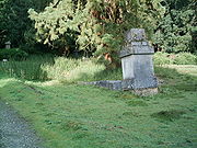
In 1900 a replica of the obelisk was placed in Brookwood Cemetery
Brookwood Cemetery
Brookwood Cemetery is a burial ground in Brookwood, Surrey, England. It is the largest cemetery in the United Kingdom and one of the largest in western Europe.-History:...
to mark where human remains from the crypt of St George the Martyr Southwark
St George the Martyr Southwark
St George the Martyr is a church in the historic Borough district of south London. It lies within the modern day London Borough of Southwark on Borough High Street at the junction with Long Lane, Marshalsea Road, and Tabard Street....
were reburied in 1899. Located on St. George the Martyr Avenue in plot 81 in the South side of the cemetery, this replica has subsequently toppled due to the subsidence of the remains beneath it.
Geography
To the north of St George's Circus is McLaren House, a hall of residence for students of London South Bank UniversityLondon South Bank University
London South Bank University is a university in south London. With over 25,000 students and 1,700 staff, it is based in the London Borough of Southwark, near the South Bank of the River Thames, from which it takes its name...
. The building was opened in 1996 and holds around 600 students. This ten-storey building replaced a derelict 1890s building that previously housed the Royal Eye Hospital.
The St George's Circus area is now a conservation area
Conservation area
A conservation areas is a tract of land that has been awarded protected status in order to ensure that natural features, cultural heritage or biota are safeguarded...
, including a number of Georgian
Georgian architecture
Georgian architecture is the name given in most English-speaking countries to the set of architectural styles current between 1720 and 1840. It is eponymous for the first four British monarchs of the House of Hanover—George I of Great Britain, George II of Great Britain, George III of the United...
buildings that formed part of the original development. Many of these had been allowed to deteriorate to near-derelict state of repair, following their purchase by the London South Bank University
London South Bank University
London South Bank University is a university in south London. With over 25,000 students and 1,700 staff, it is based in the London Borough of Southwark, near the South Bank of the River Thames, from which it takes its name...
for redevelopment plans that were subsequently abandoned, and were on the "buildings at risk" register. In 2007 facade repairs were completed to most of the buildings, although their long-term use is unresolved.
From the north and clockwise, the following roads converge here:
- Blackfriars RoadBlackfriars RoadBlackfriars Road is a road in Southwark, SE1. It runs between St George's Circus at the southern end and Blackfriars Bridge over the River Thames at the northern end, leading to the City of London. Halfway up on the west side is Southwark tube station, on the corner with The Cut...
(A201), leading to Blackfriars BridgeBlackfriars BridgeBlackfriars Bridge is a road and foot traffic bridge over the River Thames in London, between Waterloo Bridge and Blackfriars Railway Bridge, carrying the A201 road. The north end is near the Inns of Court and Temple Church, along with Blackfriars station... - Borough RoadBorough RoadBorough Road is in Southwark, London SE1. It runs east-west between St George's Circus and Borough High Street.- History and location :The route was created as part of the planning and road improvements associated with the completion of Westminster Bridge in 1750, to provide access to Southwark...
, leading to Borough High StreetBorough High StreetBorough High Street is a main street in Southwark, London running south-west from London Bridge, forming part of the A3 road, which runs from London to Portsmouth.- Overview :... - London RoadLondon Road, SouthwarkLondon Road is a road in Southwark, southeast London, England, which connects St George's Circus and the Elephant and Castle roundabout . To the east is the campus of London South Bank University including the Technopark building and the London Road Building, in a triangle formed by London Road,...
(A201), leading to Elephant and CastleElephant and CastleThe Elephant and Castle is a major road intersection in south London, England, located in the London Borough of Southwark. It is also used as a name for the surrounding area.... - Lambeth RoadLambeth RoadLambeth Road is a road in Lambeth and Southwark , London running between Lambeth Bridge over the River Thames at the western end and St George's Circus at the eastern end. The road is designated the A3203....
(A3203), leading to Lambeth BridgeLambeth BridgeLambeth Bridge is a road traffic and footbridge crossing the River Thames in an east-west direction in central London, England; the river flows north at the crossing point... - Westminster Bridge RoadWestminster Bridge RoadWestminster Bridge Road is a short, but busy, road in London, England. It runs on an east-west axis and passes through the boroughs of Lambeth and Southwark....
(A3202), leading to Westminster BridgeWestminster BridgeWestminster Bridge is a road and foot traffic bridge over the River Thames between Westminster on the north side and Lambeth on the south side, in London, England.... - Waterloo RoadWaterloo Road, LondonWaterloo Road is a road straddling Lambeth and Southwark, London, England. It runs between Westminster Bridge Road close to St George's Circus at the south-east end and Waterloo Bridge across the River Thames towards London's West End district at the north-west end.At the northern end near the...
(A301), leading to Waterloo BridgeWaterloo BridgeWaterloo Bridge is a road and foot traffic bridge crossing the River Thames in London, England between Blackfriars Bridge and Hungerford Bridge. The name of the bridge is in memory of the British victory at the Battle of Waterloo in 1815...
External links
- St George's Circus protected (July 2000) and Hotel plan for St George's Circus (August 2001), London SE1 Community website.
- History of the Obelisk.
- St George's Obelisk photograph at night.
- St George's Circus Conservation Area Appraisal LB Southwark 2005
- Guerrillagardening.org Pictures of guerrilla gardening at St George's Circus can be seen here.