
Split Rock Lighthouse State Park
Encyclopedia
Split Rock Lighthouse State Park is a state park
of Minnesota
, USA, on the North Shore
of Lake Superior
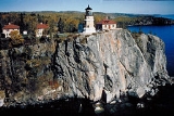
. It is best known for the picturesque Split Rock Lighthouse, one of the most photographed lighthouse
s in the United States. Built by the United States Lighthouse Service
in 1910, the lighthouse and some adjacent buildings have been restored and the Minnesota Historical Society
operates them as a museum. The 2200 acres (890.3 ha) state park offers a unique cart-in campground and scenic trails for hiking, cross-country skiing, and bicycling.
, Split Rock Point, Crazy Bay, Corundum Point, the mouth of Split Rock Creek, Day Hill, Little Two Harbors, Stony Point (site of the lighthouse), and Gold Rock Point. The name Little Two Harbors comes from the division of the inlet by a small island, formerly a tombolo
, and refers to the city of Two Harbors
farther down the shore. There are two shallow sea caves at the base of Stony Point.
The east and west branches of the Split Rock River, not to be confused with Split Rock Creek, join in the park. There are ten waterfalls on the river, although because they can only be reached by a moderate hike on the Superior Hiking Trail and are not marked on park maps, they are lightly visited.
erupted from the Midcontinent Rift System
when the middle of the North American Plate
began to crack 1.1 billion years ago. In a small tract that includes Split Rock Lighthouse State Park, additional magma intruded into the basalt and cooled underground into a harder rock called diabase
. These flows also carried with them blocks of anorthosite
, an even harder rock from the base of the Earth's crust
, which became interspersed randomly in the diabase. Three large blocks of anorthosite form Corundum Point, Day Hill, and Stony Point beneath the lighthouse. In the southwest portion of the park another eruption formed a layer of red rhyolite
. The rhyolite has eroded into several natural pillars, and forms the walls of the Split Rock River gorge.
Beginning 2 million years ago a series of glacial periods repeatedly covered the region with ice, scouring the bedrock and scooping out a great basin. The glaciers, and later meltwater, wore away less resistant rock, leaving behind hills and ridges of the harder diabase and anorthosite. At the end of the last glacial period the basin filled with meltwater. The water level fluctuated significantly over time due to blockages of the outlet and post-glacial rebound
. The high-water Glacial Lake Duluth
deposited clay sediments inland, while later, lower precursors of Lake Superior eroded bluffs and beach terraces.
and white pine
. However these were heavily logged at the beginning of the 20th Century, and wildfire
s sweeping through the cutover land killed many of the remaining saplings and seedlings. Today the vegetation is primarily birch
with some spruce
, fir
, and ash trees.
Mammals found in the park include white-tailed deer
, moose
, black bears
, raccoon
s, snowshoe hares
, red foxes
, bobcat
s, and lynx
es. A colony of beavers lives on the Split Rock River. Birds include herring gulls
, common loons, and a variety of songbirds. Peregrine falcons
nest on the lakeside cliffs.
, and herring
from 16-18 foot skiffs in the fall and winter. Little Two Harbors was inhabited until 1925, although in later years only 4 or 5 residents lived there year-round. Cement foundations of houses and fish processing buildings remain.
A logging camp known as Splitrock
existed at the mouth of the Split Rock River from 1899 to 1906. Pilings from their dam and wharf are still visible jutting from the water. The Merrill Logging Trail follows the route of their 10 miles (16.1 km) rail line. In 1901 a prospector from Duluth misidentified the outcrops of anorthosite as corundum
, an extremely hard mineral valuable as an industrial abrasive
. Three years later the North Shore Abrasives Company set up mining operations on Corundum Point, but abandoned the site in 1908 when their product was found to be inadequate. Their crushing house burned down in a forest fire in 1910 but its concrete footings remain.
Another remnant from this period is a finely crafted, freestanding stone fireplace atop Day Hill. According to local legend it was the start of a house built around 1900 by Frank Day, a businessman from Duluth, for himself and his sweetheart, but abandoned when she did not reciprocate his love.
Three violent storms struck the Great Lakes in November 1905, killing 116 sailors. One, the Mataafa Storm
of November 28, damaged nearly 30 ships on Lake Superior. Two ships were wrecked against the future park's shore, the steel steamboat
William Edenborn and a barge
it was towing, the Madeira
. The Edenborn was beached far ashore at the mouth of the Split Rock River and later salvaged
, but one of the 25 crewmembers was killed. The Madeira with 10 men aboard drifted northeast until violent waves began smashing her against the cliffs of Gold Rock Point. Crewman Fred Benson managed to leap onto the rocks and scale the cliff in the midst of the snowstorm. The first mate was swept overboard and drowned, but Benson was able to lower a rope and pull the other 8 crew to safety. The Madeira sank in pieces at the foot of Gold Rock while the crewmen, suffering from exposure and frostbite, found shelter with local fishermen and loggers. Both crews were picked up two days later by the tugboat Edna G
.
The shipping companies that had sustained losses in the storms lobbied the federal government for an expanded system of navigational aids on the Great Lakes. Besides the Edenborn and the Madeira, five other ships had been damaged within a dozen miles of the Split Rock River. A signal in that area was at the top of the industry's list of demands. The site ultimately selected for the lighthouse and fog signal was 2.5 miles (4 km) northeast of the Split Rock River, on Stony Point. There were no roads yet up the North Shore, so all construction materials were brought in by barge and hoisted up the cliff with a derrick
and a steam-powered hoist. By midsummer 1910 work was complete on the lighthouse, foghorn
building, and three houses for the lighthouse keepers.
The derrick remained the only way to bring supplies up the cliff until the lighthouse staff built a tramway in 1915-16. The station finally became accessible by a road, now Minnesota State Highway 61
, completed in 1929. Five years later a crew from the Civilian Conservation Corps
built a new access road and lighthouse tenders were provided with a truck to bring in supplies by land, so the tramway was dismantled.
The picturesque lighthouse, perched on a 130 foot cliff overlooking the world's largest lake, began attracting small numbers of visitors within weeks of its opening. However the completion of Highway 61 opened the floodgates to tourism. In 1938 it was estimated that 100,000 visitors stopped by, five times more than any other federally operated lighthouse. Some of the lighthouse keepers' children opened a souvenir stand just outside the station entrance in 1941. Both the U.S. Lighthouse Service and the U.S. Coast Guard
which absorbed it in 1939 were obliged to add seasonal staff to help conduct tours.
, a former mayor of Duluth
turned associate justice of the Minnesota Supreme Court
, noticed a sign near the Baptism River
reading "Lake and River Frontages for Sale." A staunch advocate of public lands on the North Shore, Magney determined to protect some of this land from the development boom that would accompany the end of World War II. At this time Gooseberry Falls
was the only Minnesota state park on Lake Superior. A bill promoted by Magney easily passed in the Minnesota Legislature
, creating both Baptism River State Park (now Tettegouche State Park
) and Split Rock State Scenic Wayside. The 35 acres (14.2 ha) wayside consisted of a hill offering a view of the Split Rock Lighthouse.
Due to its popularity with tourists, the lighthouse was kept operating well after radar
and other technology had rendered it obsolete. However by 1967 the Coast Guard was considering decommissioning the station. The state legislature acted to expand the wayside into a full-fledged state park including the lighthouse itself. The station was officially closed in 1969 after 59 years of service. Under the Surplus Property Act
the grounds and buildings were transferred to the state of Minnesota for free to be operated as a historic site.
The state parks division developed an entrance station, picnic grounds, roads, and trails. The Minnesota Historical Society took over management of the lighthouse station in 1976. Over the next decade they restored several buildings to their 1920 appearance and constructed a $1.2 million history center. Meanwhile from 1984 to 1990 the state park spent $555,000 to improve the recreational facilities, including a new access road, picnic area, and all-season trail shelter, and an expanded trail system. They also developed the park's first campground, an unconventional design in which campers wheel their equipment to their sites in carts provided by the park.
The Split Rock Trading Post, just outside of and unaffiliated with the state park, operated from 1960 up to 1999, when it burned down in a fire. In addition to a kitschy gift shop, this tourist trap
once boasted live bears in cages, the anchor of the Madeira, and a wooden tower offering a view of the lighthouse.
Gold Rock Point, the headland just north of the lighthouse, was not originally part of the state park. In 1997 it was purchased from its private owners by the Parks & Trails Council of Minnesota, an organization founded by Clarence Magney, among others, to buy and hold worthy properties until state legislation can authorize their public acquisition. The next year Nadine Blacklock
, a nature photographer and president of the Parks and Trails Council, was killed in a car accident just outside the north end of the park. The Council and the Blacklock Nature Sanctuary, an art and conservation non-profit organization she and her family had founded, jointly purchased 80 acres (32.4 ha) of land around the accident site. 43 acres (17.4 ha) were transferred to the state park while the remainder, with an existing one-bedroom cabin, is managed by the Blacklock Nature Sanctuary as an artists' retreat. The additions were developed with access features for Madeira wreck divers and the Gitchi-Gami State Trail, a paved bicycling route in development along the North Shore.
The park contains 14.5 miles (23.3 km) of trails for hiking, bicycling, and cross-country skiing. There are several overlooks providing views of the lighthouse and Lake Superior. A paved section of the Gitchi-Gami State Trail
runs through the park near the shore, while the Superior Hiking Trail
runs inland and skirts both the Split Rock River and Split Rock Creek. There is a lakeshore picnic area and two picnic shelters, one open year-round.
Water recreation includes boating, sea kayak
ing, and fishing for lake trout
, salmon, and brown trout
. The park also provides scuba diving
access to the Madeira wreck, which is on the National Register of Historic Places
. Divers can also see parts of the Madeira in Little Two Harbors, where they were dumped in 1974 after an aborted salvage operation. Underwater artifacts from the settlements of Splitrock and Little Two Harbors can be seen in their respective bays.
State park
State parks are parks or other protected areas managed at the federated state level within those nations which use "state" as a political subdivision. State parks are typically established by a state to preserve a location on account of its natural beauty, historic interest, or recreational...
of Minnesota
Minnesota
Minnesota is a U.S. state located in the Midwestern United States. The twelfth largest state of the U.S., it is the twenty-first most populous, with 5.3 million residents. Minnesota was carved out of the eastern half of the Minnesota Territory and admitted to the Union as the thirty-second state...
, USA, on the North Shore
North Shore (Lake Superior)
The North Shore of Lake Superior runs from Duluth, Minnesota, United States, at the southwestern end of the lake, to Thunder Bay and Nipigon, Ontario, Canada, in the north to Sault Ste. Marie, Ontario, in the east...
of Lake Superior
Lake Superior
Lake Superior is the largest of the five traditionally-demarcated Great Lakes of North America. It is bounded to the north by the Canadian province of Ontario and the U.S. state of Minnesota, and to the south by the U.S. states of Wisconsin and Michigan. It is the largest freshwater lake in the...
. It is best known for the picturesque Split Rock Lighthouse, one of the most photographed lighthouse
Lighthouse
A lighthouse is a tower, building, or other type of structure designed to emit light from a system of lamps and lenses or, in older times, from a fire, and used as an aid to navigation for maritime pilots at sea or on inland waterways....
s in the United States. Built by the United States Lighthouse Service
United States Lighthouse Service
The United States Lighthouse Service, also known as the Bureau of Lighthouses, was the agency of the US Federal Government that was responsible for the upkeep and maintenance of all lighthouses in the United States from the time of its creation in 1910 until 1939...
in 1910, the lighthouse and some adjacent buildings have been restored and the Minnesota Historical Society
Minnesota Historical Society
The Minnesota Historical Society is a private, non-profit educational and cultural institution dedicated to preserving the history of the U.S. state of Minnesota. It was founded by the territorial legislature in 1849, almost a decade before statehood. The Society is named in the Minnesota...
operates them as a museum. The 2200 acres (890.3 ha) state park offers a unique cart-in campground and scenic trails for hiking, cross-country skiing, and bicycling.
Geography
Split Rock Lighthouse State Park encompasses about 4 miles (6.4 km) of rocky shoreline on Lake Superior with several prominent headlands. Named features of the shore, from southwest to northeast, are the mouth of the Split Rock RiverSplit Rock River (Superior)
The Split Rock River is a river of Minnesota, USA. It drains a small watershed of about on the North Shore of Lake Superior. The name was used as early as 1825 and is believed to refer either to the steep-walled gorge carved by the river or to two cliffs east of the river mouth that appear split...
, Split Rock Point, Crazy Bay, Corundum Point, the mouth of Split Rock Creek, Day Hill, Little Two Harbors, Stony Point (site of the lighthouse), and Gold Rock Point. The name Little Two Harbors comes from the division of the inlet by a small island, formerly a tombolo
Tombolo
A tombolo, from the Italian tombolo, derived from the Latin tumulus, meaning 'mound,' and sometimes translated as ayre , is a deposition landform in which an island is attached to the mainland by a narrow piece of land such as a spit or bar. Once attached, the island is then known as a tied island...
, and refers to the city of Two Harbors
Two Harbors, Minnesota
As of the census of 2000, there were 3,613 people, 1,636 households, and 953 families residing in the city. The population density was 1,120.7 people per square mile . There were 1,631 housing units at an average density of 505.9 per square mile...
farther down the shore. There are two shallow sea caves at the base of Stony Point.
The east and west branches of the Split Rock River, not to be confused with Split Rock Creek, join in the park. There are ten waterfalls on the river, although because they can only be reached by a moderate hike on the Superior Hiking Trail and are not marked on park maps, they are lightly visited.
Geology
Much of the shore of Lake Superior is made of basaltBasalt
Basalt is a common extrusive volcanic rock. It is usually grey to black and fine-grained due to rapid cooling of lava at the surface of a planet. It may be porphyritic containing larger crystals in a fine matrix, or vesicular, or frothy scoria. Unweathered basalt is black or grey...
erupted from the Midcontinent Rift System
Midcontinent Rift System
The Midcontinent Rift System or Keweenawan Rift is a long geological rift in the center of the North American continent and south-central part of the North American plate. It formed when the continent's core, the North American craton, began to split apart during the Mesoproterozoic era of the...
when the middle of the North American Plate
North American Plate
The North American Plate is a tectonic plate covering most of North America, Greenland, Cuba, Bahamas, and parts of Siberia, Japan and Iceland. It extends eastward to the Mid-Atlantic Ridge and westward to the Chersky Range in eastern Siberia. The plate includes both continental and oceanic crust...
began to crack 1.1 billion years ago. In a small tract that includes Split Rock Lighthouse State Park, additional magma intruded into the basalt and cooled underground into a harder rock called diabase
Diabase
Diabase or dolerite is a mafic, holocrystalline, subvolcanic rock equivalent to volcanic basalt or plutonic gabbro. In North American usage, the term diabase refers to the fresh rock, whilst elsewhere the term dolerite is used for the fresh rock and diabase refers to altered material...
. These flows also carried with them blocks of anorthosite
Anorthosite
Anorthosite is a phaneritic, intrusive igneous rock characterized by a predominance of plagioclase feldspar , and a minimal mafic component...
, an even harder rock from the base of the Earth's crust
Crust (geology)
In geology, the crust is the outermost solid shell of a rocky planet or natural satellite, which is chemically distinct from the underlying mantle...
, which became interspersed randomly in the diabase. Three large blocks of anorthosite form Corundum Point, Day Hill, and Stony Point beneath the lighthouse. In the southwest portion of the park another eruption formed a layer of red rhyolite
Rhyolite
This page is about a volcanic rock. For the ghost town see Rhyolite, Nevada, and for the satellite system, see Rhyolite/Aquacade.Rhyolite is an igneous, volcanic rock, of felsic composition . It may have any texture from glassy to aphanitic to porphyritic...
. The rhyolite has eroded into several natural pillars, and forms the walls of the Split Rock River gorge.
Beginning 2 million years ago a series of glacial periods repeatedly covered the region with ice, scouring the bedrock and scooping out a great basin. The glaciers, and later meltwater, wore away less resistant rock, leaving behind hills and ridges of the harder diabase and anorthosite. At the end of the last glacial period the basin filled with meltwater. The water level fluctuated significantly over time due to blockages of the outlet and post-glacial rebound
Post-glacial rebound
Post-glacial rebound is the rise of land masses that were depressed by the huge weight of ice sheets during the last glacial period, through a process known as isostasy...
. The high-water Glacial Lake Duluth
Glacial Lake Duluth
Glacial Lake Duluth was a proglacial lake that formed in the Lake Superior drainage basin as the Laurentide ice sheet retreated. The oldest existing shorelines were formed after retreat from the Greatlakean advance, sometime around 11,000 years B.P. Lake Duluth formed at the western end of the Lake...
deposited clay sediments inland, while later, lower precursors of Lake Superior eroded bluffs and beach terraces.
Flora and fauna
The park was originally forested with redRed Pine
Pinus resinosa, commonly known as the red pine or Norway pine, is pine native to North America. The Red Pine occurs from Newfoundland west to Manitoba, and south to Pennsylvania, with several smaller, disjunct populations occurring in the Appalachian Mountains in Virginia and West Virginia, as well...
and white pine
Eastern White Pine
Pinus strobus, commonly known as the eastern white pine, is a large pine native to eastern North America, occurring from Newfoundland west to Minnesota and southeastern Manitoba, and south along the Appalachian Mountains to the northern edge of Georgia.It is occasionally known as simply white pine,...
. However these were heavily logged at the beginning of the 20th Century, and wildfire
Wildfire
A wildfire is any uncontrolled fire in combustible vegetation that occurs in the countryside or a wilderness area. Other names such as brush fire, bushfire, forest fire, desert fire, grass fire, hill fire, squirrel fire, vegetation fire, veldfire, and wilkjjofire may be used to describe the same...
s sweeping through the cutover land killed many of the remaining saplings and seedlings. Today the vegetation is primarily birch
Birch
Birch is a tree or shrub of the genus Betula , in the family Betulaceae, closely related to the beech/oak family, Fagaceae. The Betula genus contains 30–60 known taxa...
with some spruce
Spruce
A spruce is a tree of the genus Picea , a genus of about 35 species of coniferous evergreen trees in the Family Pinaceae, found in the northern temperate and boreal regions of the earth. Spruces are large trees, from tall when mature, and can be distinguished by their whorled branches and conical...
, fir
Fir
Firs are a genus of 48–55 species of evergreen conifers in the family Pinaceae. They are found through much of North and Central America, Europe, Asia, and North Africa, occurring in mountains over most of the range...
, and ash trees.
Mammals found in the park include white-tailed deer
White-tailed Deer
The white-tailed deer , also known as the Virginia deer or simply as the whitetail, is a medium-sized deer native to the United States , Canada, Mexico, Central America, and South America as far south as Peru...
, moose
Moose
The moose or Eurasian elk is the largest extant species in the deer family. Moose are distinguished by the palmate antlers of the males; other members of the family have antlers with a dendritic configuration...
, black bears
American black bear
The American black bear is a medium-sized bear native to North America. It is the continent's smallest and most common bear species. Black bears are omnivores, with their diets varying greatly depending on season and location. They typically live in largely forested areas, but do leave forests in...
, raccoon
Raccoon
Procyon is a genus of nocturnal mammals, comprising three species commonly known as raccoons, in the family Procyonidae. The most familiar species, the common raccoon , is often known simply as "the" raccoon, as the two other raccoon species in the genus are native only to the tropics and are...
s, snowshoe hares
Snowshoe Hare
The Snowshoe Hare , also called the Varying Hare, or Snowshoe Rabbit, is a species of hare found in North America. It has the name "snowshoe" because of the large size of its hind feet and the marks its tail leaves. The animal's feet prevent it from sinking into the snow when it hops and walks...
, red foxes
Red Fox
The red fox is the largest of the true foxes, as well as being the most geographically spread member of the Carnivora, being distributed across the entire northern hemisphere from the Arctic Circle to North Africa, Central America, and the steppes of Asia...
, bobcat
Bobcat
The bobcat is a North American mammal of the cat family Felidae, appearing during the Irvingtonian stage of around 1.8 million years ago . With twelve recognized subspecies, it ranges from southern Canada to northern Mexico, including most of the continental United States...
s, and lynx
Lynx
A lynx is any of the four Lynx genus species of medium-sized wildcats. The name "lynx" originated in Middle English via Latin from Greek word "λύγξ", derived from the Indo-European root "*leuk-", meaning "light, brightness", in reference to the luminescence of its reflective eyes...
es. A colony of beavers lives on the Split Rock River. Birds include herring gulls
American Herring Gull
The American Herring Gull or Smithsonian Gull is a large gull which breeds in North America. It is often treated as a subspecies of the European Herring Gull but is now regarded as a separate species by some authorities.Adults are white with gray back and wings, black wingtips with white spots,...
, common loons, and a variety of songbirds. Peregrine falcons
Peregrine Falcon
The Peregrine Falcon , also known as the Peregrine, and historically as the Duck Hawk in North America, is a widespread bird of prey in the family Falconidae. A large, crow-sized falcon, it has a blue-gray back, barred white underparts, and a black head and "moustache"...
nest on the lakeside cliffs.
Early history
Several vestiges of early 20th Century industry are visible in the park. The first white settlement in the Split Rock area was Little Two Harbors, a commercial fishing village populated largely by Norwegian immigrants. The men of the village fished for trout, whitefishFreshwater whitefish
The freshwater whitefish are fish of the subfamily Coregoninae in the salmon family Salmonidae. Along with the freshwater whitefish, the Salmonidae includes the freshwater and anadromous trout and salmon species as well as graylings...
, and herring
Herring
Herring is an oily fish of the genus Clupea, found in the shallow, temperate waters of the North Pacific and the North Atlantic oceans, including the Baltic Sea. Three species of Clupea are recognized. The main taxa, the Atlantic herring and the Pacific herring may each be divided into subspecies...
from 16-18 foot skiffs in the fall and winter. Little Two Harbors was inhabited until 1925, although in later years only 4 or 5 residents lived there year-round. Cement foundations of houses and fish processing buildings remain.
A logging camp known as Splitrock
Splitrock, Minnesota
Splitrock is an abandoned townsite in Beaver Bay Township, Lake County, Minnesota, United States at the mouth of the Split Rock River. It was inhabited from 1899 to 1906 as a company town to house workers for a logging operation...
existed at the mouth of the Split Rock River from 1899 to 1906. Pilings from their dam and wharf are still visible jutting from the water. The Merrill Logging Trail follows the route of their 10 miles (16.1 km) rail line. In 1901 a prospector from Duluth misidentified the outcrops of anorthosite as corundum
Corundum
Corundum is a crystalline form of aluminium oxide with traces of iron, titanium and chromium. It is a rock-forming mineral. It is one of the naturally clear transparent materials, but can have different colors when impurities are present. Transparent specimens are used as gems, called ruby if red...
, an extremely hard mineral valuable as an industrial abrasive
Abrasive
An abrasive is a material, often a mineral, that is used to shape or finish a workpiece through rubbing which leads to part of the workpiece being worn away...
. Three years later the North Shore Abrasives Company set up mining operations on Corundum Point, but abandoned the site in 1908 when their product was found to be inadequate. Their crushing house burned down in a forest fire in 1910 but its concrete footings remain.
Another remnant from this period is a finely crafted, freestanding stone fireplace atop Day Hill. According to local legend it was the start of a house built around 1900 by Frank Day, a businessman from Duluth, for himself and his sweetheart, but abandoned when she did not reciprocate his love.
Split Rock Lighthouse
-
- Main article: Split Rock Lighthouse
Three violent storms struck the Great Lakes in November 1905, killing 116 sailors. One, the Mataafa Storm
Mataafa Storm
The Mataafa Storm of 1905 is the name of a storm that occurred on the Great Lakes on November 28, 1905. The storm, named after the Mataafa wreck, ended up destroying or damaging about 29 vessels, killing 36 seamen and causing property losses of approximately $1.75 million on Lake...
of November 28, damaged nearly 30 ships on Lake Superior. Two ships were wrecked against the future park's shore, the steel steamboat
Steamboat
A steamboat or steamship, sometimes called a steamer, is a ship in which the primary method of propulsion is steam power, typically driving propellers or paddlewheels...
William Edenborn and a barge
Barge
A barge is a flat-bottomed boat, built mainly for river and canal transport of heavy goods. Some barges are not self-propelled and need to be towed by tugboats or pushed by towboats...
it was towing, the Madeira
Madeira (shipwreck)
The Madeira was built at the Chicago yard of the Chicago Shipbuilding Company in 1900 primarily of heavy steel plates that were riveted together, with wood joinery used in other places. The ship had a flat plate keel and was shaped very flat and full to maximize cargo capacity. The career of the...
. The Edenborn was beached far ashore at the mouth of the Split Rock River and later salvaged
Marine salvage
Marine salvage is the process of rescuing a ship, its cargo, or other property from peril. Salvage encompasses rescue towing, refloating a sunken or grounded vessel, or patching or repairing a ship...
, but one of the 25 crewmembers was killed. The Madeira with 10 men aboard drifted northeast until violent waves began smashing her against the cliffs of Gold Rock Point. Crewman Fred Benson managed to leap onto the rocks and scale the cliff in the midst of the snowstorm. The first mate was swept overboard and drowned, but Benson was able to lower a rope and pull the other 8 crew to safety. The Madeira sank in pieces at the foot of Gold Rock while the crewmen, suffering from exposure and frostbite, found shelter with local fishermen and loggers. Both crews were picked up two days later by the tugboat Edna G
Edna G
The Edna G is a tugboat which worked the Great Lakes. The railroad paid $35,397.50 for the Edna G. in 1896. It was out of service from 1931 to 1933 due to the depression. The Edna G. was built by the Cleveland Shipbuilding Company in 1896 for the Duluth & Iron Range RY...
.
The shipping companies that had sustained losses in the storms lobbied the federal government for an expanded system of navigational aids on the Great Lakes. Besides the Edenborn and the Madeira, five other ships had been damaged within a dozen miles of the Split Rock River. A signal in that area was at the top of the industry's list of demands. The site ultimately selected for the lighthouse and fog signal was 2.5 miles (4 km) northeast of the Split Rock River, on Stony Point. There were no roads yet up the North Shore, so all construction materials were brought in by barge and hoisted up the cliff with a derrick
Derrick
A derrick is a lifting device composed of one tower, or guyed mast such as a pole which is hinged freely at the bottom. It is controlled by lines powered by some means such as man-hauling or motors, so that the pole can move in all four directions. A line runs up it and over its top with a hook on...
and a steam-powered hoist. By midsummer 1910 work was complete on the lighthouse, foghorn
Foghorn
A foghorn or fog signal or fog bell is a device that uses sound to warn vehicles of hazards or boats of the presence of other vehicles in foggy conditions. The term is most often used in relation to marine transport...
building, and three houses for the lighthouse keepers.
The derrick remained the only way to bring supplies up the cliff until the lighthouse staff built a tramway in 1915-16. The station finally became accessible by a road, now Minnesota State Highway 61
Minnesota State Highway 61
Minnesota State Highway 61 is a highway in northeast Minnesota, which runs from the junction of Interstate Highway 35 and Minnesota 61 in Duluth and continues northeast to its northern terminus at the U.S.-Canadian border near Grand Portage...
, completed in 1929. Five years later a crew from the Civilian Conservation Corps
Civilian Conservation Corps
The Civilian Conservation Corps was a public work relief program that operated from 1933 to 1942 in the United States for unemployed, unmarried men from relief families, ages 18–25. A part of the New Deal of President Franklin D...
built a new access road and lighthouse tenders were provided with a truck to bring in supplies by land, so the tramway was dismantled.
The picturesque lighthouse, perched on a 130 foot cliff overlooking the world's largest lake, began attracting small numbers of visitors within weeks of its opening. However the completion of Highway 61 opened the floodgates to tourism. In 1938 it was estimated that 100,000 visitors stopped by, five times more than any other federally operated lighthouse. Some of the lighthouse keepers' children opened a souvenir stand just outside the station entrance in 1941. Both the U.S. Lighthouse Service and the U.S. Coast Guard
United States Coast Guard
The United States Coast Guard is a branch of the United States Armed Forces and one of the seven U.S. uniformed services. The Coast Guard is a maritime, military, multi-mission service unique among the military branches for having a maritime law enforcement mission and a federal regulatory agency...
which absorbed it in 1939 were obliged to add seasonal staff to help conduct tours.
State park creation
In 1945 Clarence R. MagneyClarence R. Magney
Clarence R. Magney was a state judge in Minnesota and the mayor of Duluth from 1917 to 1920. He was an Associate Justice of the Minnesota Supreme Court from 1943 to 1953. He was instrumental in getting a number of state parks and scenic waysides established along the North Shore of Lake Superior....
, a former mayor of Duluth
Duluth, Minnesota
Duluth is a port city in the U.S. state of Minnesota and is the county seat of Saint Louis County. The fourth largest city in Minnesota, Duluth had a total population of 86,265 in the 2010 census. Duluth is also the second largest city that is located on Lake Superior after Thunder Bay, Ontario,...
turned associate justice of the Minnesota Supreme Court
Minnesota Supreme Court
The Minnesota Supreme Court is the highest court in the U.S. state of Minnesota and consists of seven members. The court was first assembled as a three-judge panel in 1849 when Minnesota was still a territory. The first members were lawyers from outside of the region who were appointed by...
, noticed a sign near the Baptism River
Baptism River
The Baptism River is a river of Minnesota. The High Falls of the Baptism River, in Tettegouche State Park, is the highest waterfall entirely within the state of Minnesota at . The High Falls on the Pigeon River is higher, but is on the border with Ontario....
reading "Lake and River Frontages for Sale." A staunch advocate of public lands on the North Shore, Magney determined to protect some of this land from the development boom that would accompany the end of World War II. At this time Gooseberry Falls
Gooseberry Falls State Park
Gooseberry Falls State Park is a state park of Minnesota, USA, on the North Shore of Lake Superior. The park is located in Silver Creek Township, about 13 miles northeast of Two Harbors, Minnesota in Lake County on scenic Minnesota Highway 61. The Joseph N...
was the only Minnesota state park on Lake Superior. A bill promoted by Magney easily passed in the Minnesota Legislature
Minnesota Legislature
The Minnesota Legislature is the legislative branch of government in the U.S. state of Minnesota. It is a bicameral legislature located at the Minnesota Capitol in Saint Paul and it consists of two houses: the lower Minnesota House of Representatives and the Minnesota Senate...
, creating both Baptism River State Park (now Tettegouche State Park
Tettegouche State Park
Tettegouche State Park is a Minnesota state park on the north shore of Lake Superior 58 miles northeast of Duluth in Lake County on scenic Minnesota Highway 61. The park's name stems from the Tettegouche Club, an association of local businessmen which purchased the park in 1910 from the...
) and Split Rock State Scenic Wayside. The 35 acres (14.2 ha) wayside consisted of a hill offering a view of the Split Rock Lighthouse.
Due to its popularity with tourists, the lighthouse was kept operating well after radar
Radar
Radar is an object-detection system which uses radio waves to determine the range, altitude, direction, or speed of objects. It can be used to detect aircraft, ships, spacecraft, guided missiles, motor vehicles, weather formations, and terrain. The radar dish or antenna transmits pulses of radio...
and other technology had rendered it obsolete. However by 1967 the Coast Guard was considering decommissioning the station. The state legislature acted to expand the wayside into a full-fledged state park including the lighthouse itself. The station was officially closed in 1969 after 59 years of service. Under the Surplus Property Act
Surplus Property Act
The Surplus Property Act of 1944 is an act of the United States Congress that was enacted to provide for the disposal of surplus government property to "a State, political subdivision of a State, or tax-supported organization"...
the grounds and buildings were transferred to the state of Minnesota for free to be operated as a historic site.
The state parks division developed an entrance station, picnic grounds, roads, and trails. The Minnesota Historical Society took over management of the lighthouse station in 1976. Over the next decade they restored several buildings to their 1920 appearance and constructed a $1.2 million history center. Meanwhile from 1984 to 1990 the state park spent $555,000 to improve the recreational facilities, including a new access road, picnic area, and all-season trail shelter, and an expanded trail system. They also developed the park's first campground, an unconventional design in which campers wheel their equipment to their sites in carts provided by the park.
The Split Rock Trading Post, just outside of and unaffiliated with the state park, operated from 1960 up to 1999, when it burned down in a fire. In addition to a kitschy gift shop, this tourist trap
Tourist trap
A tourist trap is an establishment, or group of establishments, that has been created with the aim of attracting tourists and their money...
once boasted live bears in cages, the anchor of the Madeira, and a wooden tower offering a view of the lighthouse.
Gold Rock Point, the headland just north of the lighthouse, was not originally part of the state park. In 1997 it was purchased from its private owners by the Parks & Trails Council of Minnesota, an organization founded by Clarence Magney, among others, to buy and hold worthy properties until state legislation can authorize their public acquisition. The next year Nadine Blacklock
Nadine Blacklock
Nadine Blacklock was a nature photographer best known for her detailed nature photography of the Lake Superior area. She was married to Craig Blacklock, a well-known photographer in his own right...
, a nature photographer and president of the Parks and Trails Council, was killed in a car accident just outside the north end of the park. The Council and the Blacklock Nature Sanctuary, an art and conservation non-profit organization she and her family had founded, jointly purchased 80 acres (32.4 ha) of land around the accident site. 43 acres (17.4 ha) were transferred to the state park while the remainder, with an existing one-bedroom cabin, is managed by the Blacklock Nature Sanctuary as an artists' retreat. The additions were developed with access features for Madeira wreck divers and the Gitchi-Gami State Trail, a paved bicycling route in development along the North Shore.
Recreation
Split Rock Lighthouse State Park has a unique cart-in campground with 20 secluded campsites and a modern restroom. Campers leave their vehicles in a parking lot and use two-wheeled carts provided by the park to carry their equipment a short distance to their site. There are four backpack campsites along the shore, two accessible to sea kayakers. Conventional drive-in campgrounds managed by the state park are available in two state forests in the area. An expansion of the state park campground, to include 60 drive-in sites, has been approved and construction may begin in summer 2010.The park contains 14.5 miles (23.3 km) of trails for hiking, bicycling, and cross-country skiing. There are several overlooks providing views of the lighthouse and Lake Superior. A paved section of the Gitchi-Gami State Trail
Gitchi-Gami State Trail
The Gitchi-Gami State Trail is a multi-use recreational trail in development along the North Shore of Lake Superior in Minnesota, USA. Planned to extend from Two Harbors to Grand Marais, the trail currently comprises five unconnected segments...
runs through the park near the shore, while the Superior Hiking Trail
Superior Hiking Trail
The Superior Hiking Trail, also known as The “SHT,” is a 275-mile long footpath in Northeastern Minnesota, which for most of its length follows the ridgeline overlooking Lake Superior. The path is 18-inches wide and is set in the middle of a 4 foot clearing. The footpath travels through forests of...
runs inland and skirts both the Split Rock River and Split Rock Creek. There is a lakeshore picnic area and two picnic shelters, one open year-round.
Water recreation includes boating, sea kayak
Sea kayak
A sea kayak or touring kayak is a kayak developed for the sport of paddling on open waters of lakes, bays, and the ocean. Sea kayaks are seaworthy small boats with a covered deck and the ability to incorporate a spraydeck...
ing, and fishing for lake trout
Lake trout
Lake trout is a freshwater char living mainly in lakes in northern North America. Other names for it include mackinaw, lake char , touladi, togue, and grey trout. In Lake Superior, they can also be variously known as siscowet, paperbellies and leans...
, salmon, and brown trout
Brown trout
The brown trout and the sea trout are fish of the same species....
. The park also provides scuba diving
Scuba diving
Scuba diving is a form of underwater diving in which a diver uses a scuba set to breathe underwater....
access to the Madeira wreck, which is on the National Register of Historic Places
National Register of Historic Places
The National Register of Historic Places is the United States government's official list of districts, sites, buildings, structures, and objects deemed worthy of preservation...
. Divers can also see parts of the Madeira in Little Two Harbors, where they were dumped in 1974 after an aborted salvage operation. Underwater artifacts from the settlements of Splitrock and Little Two Harbors can be seen in their respective bays.