

Southern Shore Region
Encyclopedia
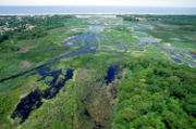
The Southern Shore Region is located in the southeastern part of State of New Jersey in the United States of America. It is one of six tourism regions established by the New Jersey State Department of Tourism, the others being the Gateway Region
, Greater Atlantic City
, the Delaware River Region
, the Shore Region
and the Skylands Region
. . The area includes Cape May County
and Cumberland County
. The coast is along the Atlantic Ocean
and Delaware Bay
, while the inland areas are part of the New Jersey Pine Barrens
.
Gateway Region
The Gateway Region is located in the northeastern part of State of New Jersey in the United States of America. The area encompasses Bergen, Essex, Hudson, Passaic, Union and Middlesex counties...
, Greater Atlantic City
Atlantic City, New Jersey
Atlantic City is a city in Atlantic County, New Jersey, United States, and a nationally renowned resort city for gambling, shopping and fine dining. The city also served as the inspiration for the American version of the board game Monopoly. Atlantic City is located on Absecon Island on the coast...
, the Delaware River Region
Delaware River Region
The Delaware River Region refers to an area in western New Jersey along the Delaware River border with Pennsylvania. It encompasses Burlington County, Camden County, Gloucester County, Mercer County, and Salem County. The area is primarily part of Greater Philadelphia with the exception of Mercer...
, the Shore Region
Shore Region
The Shore Region of the state of New Jersey encompasses Monmouth and Ocean Counties, and is often called the Jersey Shore. It is one of six such officially recognized tourism regions, the others being the Greater Atlantic City Region, the Southern Shore Region, the Delaware River Region, the...
and the Skylands Region
Skylands Region
The Skylands Region is a marketing area of the State of New Jersey located in the Northern and Central part of the state. It is one of six tourism regions established by the New Jersey State Department of Tourism, the others being the Gateway Region, Greater Atlantic City Region, the Southern...
. . The area includes Cape May County
Cape May County, New Jersey
-Climate:Being the southernmost point in New Jersey, Cape May has fairly mild wintertime temperatures. Contrary to that, the summertime has lower temperatures than most places in the state, making the county a popular place to escape the heat. It is in zone 7a/7b, which is the same as parts of...
and Cumberland County
Cumberland County, New Jersey
Cumberland County is a county located in the U.S. state of New Jersey. As of the 2010 Census, the population is 156,898. Its county seat is Bridgeton. Cumberland County is named for Prince William, Duke of Cumberland....
. The coast is along the Atlantic Ocean
Atlantic Ocean
The Atlantic Ocean is the second-largest of the world's oceanic divisions. With a total area of about , it covers approximately 20% of the Earth's surface and about 26% of its water surface area...
and Delaware Bay
Delaware Bay
Delaware Bay is a major estuary outlet of the Delaware River on the Northeast seaboard of the United States whose fresh water mixes for many miles with the waters of the Atlantic Ocean. It is in area. The bay is bordered by the State of New Jersey and the State of Delaware...
, while the inland areas are part of the New Jersey Pine Barrens
Pine Barrens (New Jersey)
The Pine Barrens, also known as the Pinelands, is a heavily forested area of coastal plain stretching across southern New Jersey. The name "pine barrens" refers to the area's sandy, acidic, nutrient-poor soil, to which the crops originally imported by European settlers didn't take well...
.
Places
- Cape May
- Cape May – Lewes Ferry
- The WildwoodsThe WildwoodsThe Wildwoods are a group of five municipalities in Cape May County, New Jersey, all of which are situated on the Island of Five Mile Beach, a barrier island facing the Atlantic Ocean...
- The Pine BarrensPine Barrens (New Jersey)The Pine Barrens, also known as the Pinelands, is a heavily forested area of coastal plain stretching across southern New Jersey. The name "pine barrens" refers to the area's sandy, acidic, nutrient-poor soil, to which the crops originally imported by European settlers didn't take well...
- New Jersey Pinelands National ReserveNew Jersey Pinelands National ReserveNew Jersey Pinelands National Reserve preserves the New Jersey Pine Barrens.The Pinelands is a unique location of historic villages and berry farms amid the vast oak-pine forests , extensive wetlands, and diverse species of plants and animals of the Atlantic coastal pine barrens ecoregion...
- The Glades (New Jersey)The Glades (New Jersey)The Glades is a name for in southern New Jersey along the Delaware Bay. The formal name of this preserve is The Glades Wildlife Refuge and is publicly accessible at several points...
- Bear Swamp, New JerseyBear Swamp, New JerseyBear Swamp is a swamp in Cumberland County, southwestern New Jersey, notable for its of old-growth forests and the birds they contain. It is divided into two areas, Bear Swamp East and Bear Swamp West, separated from each other by gravel mines and roads....
Points of interest
- Cape May Seashore LinesCape May Seashore LinesCape May Seashore Lines is a short line railroad in southern New Jersey. It offers two excursion services; a 30-mile round trip between Richland and Tuckahoe, and a 14-mile round trip between Rio Grande, Cold Spring Village, and Cape May City. The track is owned by New Jersey Transit and leased to...
- National Register of Historic Places listings in Cumberland County, New Jersey
- National Register of Historic Places listings in Cape May County, New Jersey
- Vineland has the only remaining drive-in theaterDrive-in theaterA drive-in theater is a form of cinema structure consisting of a large outdoor screen, a projection booth, a concession stand and a large parking area for automobiles. Within this enclosed area, customers can view movies from the privacy and comfort of their cars.The screen can be as simple as a...
,The Delsea Drive-In, in the state of New Jersey, the state in which they were created in 1932. It is located on Route 47 (Delsea Drive) north of County Route 552County Route 552 (New Jersey)County Route 552, abbreviated CR 552, is a county highway in the U.S. state of New Jersey. The highway extends from Laurel Street in Bridgeton to Harding Highway in Hamilton Township.-Cumberland County:...
. - Corson's Inlet State ParkCorson's Inlet State ParkCorson's Inlet State Park was established by the New Jersey Legislature in the early 1960s to protect and preserve one of the last undeveloped tracts of land along the state’s oceanfront. The park borders Corson Inlet...
- Cape May Migratory Bird Refuge (The Nature ConservancyThe Nature ConservancyThe Nature Conservancy is a US charitable environmental organization that works to preserve the plants, animals, and natural communities that represent the diversity of life on Earth by protecting the lands and waters they need to survive....
's William D. & Jane C. Blair Jr.) - The Wetlands InstituteThe Wetlands InstituteThe Wetlands Institute is a non-profit organization started in 1969 by WWF executive director Herbert Mills. The Wetlands Institute sits on 6,000 acres of protected wetlands in Stone Harbor, New Jersey...
- Higbee Beach Wildlife Management Area
- Tuckahoe Wildlife Management Area
- The Vineland Haunted house is also a tourist attraction. In the late 70s a family moved in and encountered several paranormal problems. Including a gravestone moving across a field by itself when it would take 4 or more strong people to move it.
Events
- Lima Bean Festival
- Water and Wings FesitvalThe Wetlands InstituteThe Wetlands Institute is a non-profit organization started in 1969 by WWF executive director Herbert Mills. The Wetlands Institute sits on 6,000 acres of protected wetlands in Stone Harbor, New Jersey...
- Southern Shore Music Festival
- Wildwoods Country Music Weekend October 22-23, 2010
See also
- Atlantic coastal plainAtlantic Coastal PlainThe Atlantic coastal plain has both low elevation and low relief, but it is also a relatively flat landform extending from the New York Bight southward to a Georgia/Florida section of the Eastern Continental Divide, which demarcates the plain from the ACF River Basin in the Gulf Coastal Plain to...
- KechemecheKechemecheKechemeche is the name of a Lenape tribe of Native Americans that lived in the area generally known today as the southern portion of Cape May County, New Jersey, an area bounded on one side by the Atlantic Ocean, and the Delaware River Bay on another....
- South JerseySouth JerseySouth Jersey comprises the southern portions of the U.S. state of New Jersey between the lower Delaware River and the Atlantic Ocean. The designation is a colloquial one, reflecting not only geographical but perceived cultural differences from the northern part of the state, with no official...
- Regions of New Jersey
- Garden State ParkwayGarden State ParkwayThe Garden State Parkway is a 172.4-mile limited-access toll parkway that stretches the length of New Jersey from the New York line at Montvale, New Jersey, to Cape May at New Jersey's southernmost tip. Its name refers to New Jersey's nickname, the "Garden State." Most New Jersey residents refer...
- New Jersey Coastal Heritage Trail RouteNew Jersey Coastal Heritage Trail RouteThe New Jersey Coastal Heritage Trail Route extends along New Jersey's Atlantic Ocean shore for nearly 300 miles, from Perth Amboy to Cape May and westward along the Delaware Bay to the Delaware Memorial Bridge...