

Southeast Expressway (Massachusetts)
Encyclopedia
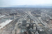
The Southeast Expressway is a limited-access road
located between the Braintree Split
and the Thomas P. O'Neill Jr. Tunnel
in the suburbs of Boston, Massachusetts as well as the city itself. It carries Interstate 93
, U.S. Route 1
and Massachusetts Route 3.
 The Southeast Expressway was constructed between 1954 and 1959, at the same time the John F. Fitzgerald Expressway (Central Artery) was built. Its northern terminus is at Exit 18 (Massachusetts Avenue) in South Boston, a former Y-interchange where the cancelled Inner Belt
(I-695) was to meet with the expressway and the Central Artery. The southern terminus is at the Y-interchange (the "Braintree Split
") at Exit 7 in Braintree (where Route 128 "unofficially" begins).
A section of the Expressway, beginning south of the Savin Hill overpass and ending just before the junction with Route 3
, utilizes a zipper lane, in which a movable barrier carves out a reversible high occupancy vehicle lane on the non-peak side of the highway during rush hour
.
Limited-access road
A limited-access road known by various terms worldwide, including limited-access highway, dual-carriageway and expressway, is a highway or arterial road for high-speed traffic which has many or most characteristics of a controlled-access highway , including limited or no access to adjacent...
located between the Braintree Split
Braintree Split
The Braintree Split is the intersection of Interstate 93/U.S. Route 1 and Massachusetts Route 3 located along the city line separating Braintree and Quincy, Massachusetts. The Braintree Split was also the southern end of Route 128 until 1997, when Route 128 was truncated to the I-95/I-93...
and the Thomas P. O'Neill Jr. Tunnel
Thomas P. O'Neill Jr. Tunnel
The Thomas P. "Tip" O'Neill, Jr. Tunnel is a highway tunnel built as part of the Big Dig in Boston, Massachusetts. It carries the Central Artery underneath downtown Boston, and is numbered as Interstate 93, U.S. Route 1, and Route 3. It roughly follows the route of the old elevated Central Artery,...
in the suburbs of Boston, Massachusetts as well as the city itself. It carries Interstate 93
Interstate 93
Interstate 93 is an Interstate Highway in the New England section of the United States. Its southern terminus is in Canton, Massachusetts, in the Boston metropolitan area, at Interstate 95; its northern terminus is near St. Johnsbury, Vermont, at Interstate 91...
, U.S. Route 1
U.S. Route 1
U.S. Route 1 is a major north–south U.S. Highway that serves the East Coast of the United States. It runs 2,377 miles from Fort Kent, Maine at the Canadian border south to Key West, Florida. U.S. 1 generally parallels Interstate 95, though it is significantly farther west between...
and Massachusetts Route 3.
History
Interstate 695 (Massachusetts)
The Inner Belt in Boston was a planned six-lane, limited-access highway that would have run through parts of Boston, Brookline, Cambridge, and Somerville.-History:...
(I-695) was to meet with the expressway and the Central Artery. The southern terminus is at the Y-interchange (the "Braintree Split
Braintree Split
The Braintree Split is the intersection of Interstate 93/U.S. Route 1 and Massachusetts Route 3 located along the city line separating Braintree and Quincy, Massachusetts. The Braintree Split was also the southern end of Route 128 until 1997, when Route 128 was truncated to the I-95/I-93...
") at Exit 7 in Braintree (where Route 128 "unofficially" begins).
A section of the Expressway, beginning south of the Savin Hill overpass and ending just before the junction with Route 3
Route 3 (Massachusetts)
Route 3 is a southward continuation of U.S. Route 3, connecting Cambridge, Massachusetts with Cape Cod. All of it, except for the northernmost end in downtown Boston and Cambridge, is a freeway....
, utilizes a zipper lane, in which a movable barrier carves out a reversible high occupancy vehicle lane on the non-peak side of the highway during rush hour
Rush hour
A rush hour or peak hour is a part of the day during which traffic congestion on roads and crowding on public transport is at its highest. Normally, this happens twice a day—once in the morning and once in the evening, the times during when the most people commute...
.