

South Pole-Aitken basin
Encyclopedia
The South Pole-Aitken basin is an impact crater
on Earth
's Moon
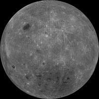
. Roughly 2500 kilometres (1,553.4 mi) in diameter and 13 kilometres (8.1 mi) deep, it is one of the largest known impact craters in the Solar System. It is the largest, oldest and deepest basin recognized on the Moon. This moon basin was named for two features on opposing sides; the crater Aitken
on the northern end and the southern lunar pole at the other end. The outer rim of this basin can be seen from Earth as a huge chain of mountains located on the lunar southern limb, sometimes called "Leibnitz mountains", although this name has not been considered official by the International Astronomical Union
.
and Zond 3
), but it was not until the acquisition of global photography by the Lunar Orbiter program
in the mid-1960s that geologists recognized its true size. Laser altimeter data obtained during the Apollo 15 and 16 missions showed that the northern portion of this basin was very deep, but since these data were only available along the near-equatorial ground track
s of the orbiting Command and Service Modules, the topography of the rest of the basin remained unknown. The first complete geologic map showing the confines of this basin was published in 1978 by the United States Geological Survey
. Little was known about the basin until the 1990s, when the spacecraft Galileo and Clementine
visited the Moon. Multispectral images obtained from these missions showed that this basin contains more FeO and TiO2
than typical lunar highlands, and hence has a darker appearance. The topography of the basin was mapped in its entirety for the first time using altimeter data and the analysis of stereo image pairs taken during the Clementine mission
. Most recently, the composition of this basin has been further constrained by the analysis of data obtained from a gamma-ray spectrometer that was on board the Lunar Prospector
mission.
 The South Pole-Aitken basin is the largest, deepest and oldest basin recognized on the Moon. The lowest elevations of the Moon (about -6 km) are located within the South Pole-Aitken basin, and the highest elevations (about +8 km) are found on this basin's north-eastern rim. Because of this basin's great size, the crust at this locale is expected to be thinner than typical as a result of the large amount of material that would have been excavated during this impact event. Crustal thickness maps constructed using the Moon's topography and gravity field imply a thickness of about 15 km beneath the floor of this basin, in comparison to the global average of about 50 km.
The composition of this basin, as estimated from the Galileo, Clementine
and Lunar Prospector
missions, show that it is different from typical highland regions. Most importantly, none of the samples obtained from the American Apollo
and Russian Luna
missions, nor the handful of identified lunar meteorites, have a composition that is comparable. The orbital data indicate that the floor of this basin has slightly elevated abundances of iron, titanium, and thorium. In terms of mineralogy, the basin floor is much richer in clinopyroxene and orthopyroxene than the surrounding highlands that are largely anorthositic. Several possibilities exist for this distinctive chemical signature. One is that this composition might simply represent lower crustal materials that are somewhat more rich in iron, titanium and thorium than the upper crust. Another possibility is that this composition reflects the widespread distribution of ponds of iron-rich basalt
s, similar to those that make up the lunar maria
. Alternatively, the rocks here could contain a component from the lunar mantle if the basin excavated all the way through the crust. The origin of the anomalous composition of this basin is not known with certainty at this time, however, and a sample return mission will most likely be required to settle this debate. Complicating matters is the fact that all three of the above hypotheses could contribute to the anomalous geochemical signature of this giant crater. Furthermore, it is possible that a large portion of the lunar surface in the vicinity of this basin was melted during the impact event, and differentiation of this impact melt sheet could have given rise to additional geochemical anomalies.
Impact crater
In the broadest sense, the term impact crater can be applied to any depression, natural or manmade, resulting from the high velocity impact of a projectile with a larger body...
on Earth
Earth
Earth is the third planet from the Sun, and the densest and fifth-largest of the eight planets in the Solar System. It is also the largest of the Solar System's four terrestrial planets...
's Moon
Moon
The Moon is Earth's only known natural satellite,There are a number of near-Earth asteroids including 3753 Cruithne that are co-orbital with Earth: their orbits bring them close to Earth for periods of time but then alter in the long term . These are quasi-satellites and not true moons. For more...
. Roughly 2500 kilometres (1,553.4 mi) in diameter and 13 kilometres (8.1 mi) deep, it is one of the largest known impact craters in the Solar System. It is the largest, oldest and deepest basin recognized on the Moon. This moon basin was named for two features on opposing sides; the crater Aitken
Aitken (crater)
Aitken is a large lunar impact crater that lies on the far side of the Moon, named for Robert Grant Aitken, an American astronomer specializing in binary stellar systems. It is located to the southeast of the crater Heaviside, and north of the unusual formation Van de Graaff. Attached to the...
on the northern end and the southern lunar pole at the other end. The outer rim of this basin can be seen from Earth as a huge chain of mountains located on the lunar southern limb, sometimes called "Leibnitz mountains", although this name has not been considered official by the International Astronomical Union
International Astronomical Union
The International Astronomical Union IAU is a collection of professional astronomers, at the Ph.D. level and beyond, active in professional research and education in astronomy...
.
Discovery
The existence of a giant far side basin was suspected as early as 1962 based on early probe images (namely Luna 3Luna 3
The Soviet space probe Luna 3 of 1959 was the third space probe to be sent to the neighborhood of the Moon, and this mission was an early feat in the spaceborne exploration of outer space...
and Zond 3
Zond 3
Zond 3 was a member of the Soviet Zond program sharing designation Zond, while being part of Mars 3MV project. It was unrelated to Zond spacecraft designed for manned circumlunar mission . Zond 3 completed a successful Lunar flyby, taking a number of good quality photographs for its time...
), but it was not until the acquisition of global photography by the Lunar Orbiter program
Lunar Orbiter program
The Lunar Orbiter program was a series of five unmanned lunar orbiter missions launched by the United States from 1966 through 1967. Intended to help select Apollo landing sites by mapping the Moon's surface, they provided the first photographs from lunar orbit.All five missions were successful,...
in the mid-1960s that geologists recognized its true size. Laser altimeter data obtained during the Apollo 15 and 16 missions showed that the northern portion of this basin was very deep, but since these data were only available along the near-equatorial ground track
Ground track
A ground track or ground trace is the path on the surface of the Earth directly below an aircraft or satellite. In the case of a satellite, it is the projection of the satellite's orbit onto the surface of the Earth .A satellite ground track may be thought of as a path along the Earth's surface...
s of the orbiting Command and Service Modules, the topography of the rest of the basin remained unknown. The first complete geologic map showing the confines of this basin was published in 1978 by the United States Geological Survey
United States Geological Survey
The United States Geological Survey is a scientific agency of the United States government. The scientists of the USGS study the landscape of the United States, its natural resources, and the natural hazards that threaten it. The organization has four major science disciplines, concerning biology,...
. Little was known about the basin until the 1990s, when the spacecraft Galileo and Clementine
Clementine mission
Clementine was a joint space project between the Ballistic Missile Defense Organization and NASA...
visited the Moon. Multispectral images obtained from these missions showed that this basin contains more FeO and TiO2
Titanium dioxide
Titanium dioxide, also known as titanium oxide or titania, is the naturally occurring oxide of titanium, chemical formula . When used as a pigment, it is called titanium white, Pigment White 6, or CI 77891. Generally it comes in two different forms, rutile and anatase. It has a wide range of...
than typical lunar highlands, and hence has a darker appearance. The topography of the basin was mapped in its entirety for the first time using altimeter data and the analysis of stereo image pairs taken during the Clementine mission
Clementine mission
Clementine was a joint space project between the Ballistic Missile Defense Organization and NASA...
. Most recently, the composition of this basin has been further constrained by the analysis of data obtained from a gamma-ray spectrometer that was on board the Lunar Prospector
Lunar Prospector
The Lunar Prospector mission was the third selected by NASA for full development and construction as part of the Discovery Program. At a cost of $62.8 million, the 19-month mission was designed for a low polar orbit investigation of the Moon, including mapping of surface composition and possible...
mission.
Physical characteristics
The composition of this basin, as estimated from the Galileo, Clementine
Clementine mission
Clementine was a joint space project between the Ballistic Missile Defense Organization and NASA...
and Lunar Prospector
Lunar Prospector
The Lunar Prospector mission was the third selected by NASA for full development and construction as part of the Discovery Program. At a cost of $62.8 million, the 19-month mission was designed for a low polar orbit investigation of the Moon, including mapping of surface composition and possible...
missions, show that it is different from typical highland regions. Most importantly, none of the samples obtained from the American Apollo
Project Apollo
The Apollo program was the spaceflight effort carried out by the United States' National Aeronautics and Space Administration , that landed the first humans on Earth's Moon. Conceived during the Presidency of Dwight D. Eisenhower, Apollo began in earnest after President John F...
and Russian Luna
Luna programme
The Luna programme , occasionally called Lunik or Lunnik, was a series of robotic spacecraft missions sent to the Moon by the Soviet Union between 1959 and 1976. Fifteen were successful, each designed as either an orbiter or lander, and accomplished many firsts in space exploration...
missions, nor the handful of identified lunar meteorites, have a composition that is comparable. The orbital data indicate that the floor of this basin has slightly elevated abundances of iron, titanium, and thorium. In terms of mineralogy, the basin floor is much richer in clinopyroxene and orthopyroxene than the surrounding highlands that are largely anorthositic. Several possibilities exist for this distinctive chemical signature. One is that this composition might simply represent lower crustal materials that are somewhat more rich in iron, titanium and thorium than the upper crust. Another possibility is that this composition reflects the widespread distribution of ponds of iron-rich basalt
Basalt
Basalt is a common extrusive volcanic rock. It is usually grey to black and fine-grained due to rapid cooling of lava at the surface of a planet. It may be porphyritic containing larger crystals in a fine matrix, or vesicular, or frothy scoria. Unweathered basalt is black or grey...
s, similar to those that make up the lunar maria
Lunar mare
The lunar maria are large, dark, basaltic plains on Earth's Moon, formed by ancient volcanic eruptions. They were dubbed maria, Latin for "seas", by early astronomers who mistook them for actual seas. They are less reflective than the "highlands" as a result of their iron-rich compositions, and...
. Alternatively, the rocks here could contain a component from the lunar mantle if the basin excavated all the way through the crust. The origin of the anomalous composition of this basin is not known with certainty at this time, however, and a sample return mission will most likely be required to settle this debate. Complicating matters is the fact that all three of the above hypotheses could contribute to the anomalous geochemical signature of this giant crater. Furthermore, it is possible that a large portion of the lunar surface in the vicinity of this basin was melted during the impact event, and differentiation of this impact melt sheet could have given rise to additional geochemical anomalies.
Origin
Simulations of near vertical impacts show that this basin should have dug up vast amounts of mantle materials from depths as great as 200 km below the surface. However, observations thus far do not favor a mantle composition for this basin, and crustal thickness maps seem to indicate the presence of about 10 kilometers of crustal materials beneath this basin's floor. This has suggested to some that the basin was not formed by a typical high-velocity impact, but may instead have been formed by a low-velocity projectile that hit at a low angle (about 30 degrees or less), and hence did not dig very deeply into the Moon. Putative evidence for this comes from the high elevations north-east of the rim of the South Pole-Aitken basin that might represent ejecta from such an oblique impact.See also
- Far side of the MoonFar side of the MoonThe far side of the Moon is the lunar hemisphere that is permanently turned away, and is not visible from the surface of the Earth. The far hemisphere was first photographed by the Soviet Luna 3 probe in 1959, and was first directly observed by human eyes when the Apollo 8 mission orbited the Moon...
- Geology of the MoonGeology of the MoonThe geology of the Moon is quite different from that of the Earth...
- Lunar south poleLunar south poleThe lunar south pole is of special interest to scientists because of the postulated occurrence of ice in permanently shadowed areas. Of the lunar poles, the south pole is of greater interest because the area that remains in shadow is much larger than that at the north pole. The lunar south pole...
- Impact craterImpact craterIn the broadest sense, the term impact crater can be applied to any depression, natural or manmade, resulting from the high velocity impact of a projectile with a larger body...
- Lunar craters