

South Cameroon Plateau
Encyclopedia
Cameroon
Cameroon, officially the Republic of Cameroon , is a country in west Central Africa. It is bordered by Nigeria to the west; Chad to the northeast; the Central African Republic to the east; and Equatorial Guinea, Gabon, and the Republic of the Congo to the south. Cameroon's coastline lies on the...
. The plateau lies south of the Adamawa Plateau
Adamawa Plateau
The Adamawa Plateau is a plateau region in west-central Africa stretching from south-eastern Nigeria through north-central Cameroon to the Central African Republic. The plateau was named after Fulani Muslim leader Modibo Adama. The part of the plateau that lies in Nigeria is more popularly known...
and southeast of the Cameroon Range
Cameroon line
The Cameroon line is a chain of volcanoes.It includes islands in the Gulf of Guinea and mountains that extend along the border region of eastern Nigeria and western Cameroon, from Mount Cameroon on the Gulf of Guinea north and east towards Lake Chad....
. It slopes south and west until giving way to the Cameroon coastal plain in the southwest and the Congo River
Congo River
The Congo River is a river in Africa, and is the deepest river in the world, with measured depths in excess of . It is the second largest river in the world by volume of water discharged, though it has only one-fifth the volume of the world's largest river, the Amazon...
basin in the southeast. The plateau is characterised by hills and valleys in the southwest and a more gentle peneplain
Peneplain
A peneplain is a low-relief plain representing the final stage of fluvial erosion during times of extended tectonic stability. The existence of peneplains, and peneplanation as a geomorphological process, is not without controversy, due to a lack of contemporary examples and uncertainty in...
in the southwest. Isolated massif
Massif
In geology, a massif is a section of a planet's crust that is demarcated by faults or flexures. In the movement of the crust, a massif tends to retain its internal structure while being displaced as a whole...
s occur, especially in the southwest. Metamorphic rock
Metamorphic rock
Metamorphic rock is the transformation of an existing rock type, the protolith, in a process called metamorphism, which means "change in form". The protolith is subjected to heat and pressure causing profound physical and/or chemical change...
s make up the plain's basement. The soils are ferrallitic and lateritic
Laterite
Laterites are soil types rich in iron and aluminium, formed in hot and wet tropical areas. Nearly all laterites are rusty-red because of iron oxides. They develop by intensive and long-lasting weathering of the underlying parent rock...
, with colouration ranging from red or brown in the interior to yellow on the coast. The soils are subjected to silica leeching, so they are not productive without fertiliser.
The plateau experiences four major season
Season
A season is a division of the year, marked by changes in weather, ecology, and hours of daylight.Seasons result from the yearly revolution of the Earth around the Sun and the tilt of the Earth's axis relative to the plane of revolution...
s, two rainy
Wet season
The the wet season, or rainy season, is the time of year, covering one or more months, when most of the average annual rainfall in a region occurs. The term green season is also sometimes used as a euphemism by tourist authorities. Areas with wet seasons are dispersed across portions of the...
, and two dry
Dry season
The dry season is a term commonly used when describing the weather in the tropics. The weather in the tropics is dominated by the tropical rain belt, which oscillates from the northern to the southern tropics over the course of the year...
. Rainfall is high, especially along the coast. The average temperature changes little from 25°C. River
River
A river is a natural watercourse, usually freshwater, flowing towards an ocean, a lake, a sea, or another river. In a few cases, a river simply flows into the ground or dries up completely before reaching another body of water. Small rivers may also be called by several other names, including...
s in the region drain into the Atlantic Ocean
Atlantic Ocean
The Atlantic Ocean is the second-largest of the world's oceanic divisions. With a total area of about , it covers approximately 20% of the Earth's surface and about 26% of its water surface area...
and the Congo River basin. South of the Sanaga
Sanaga River
The Sanaga River is a river of South Province, Cameroon, Centre Province, Cameroon, and West Province, Cameroon. Its length is 890 kilometers.The Sanaga River forms a boundary between two tropical moist forest ecoregions...
, rivers flow steadily year-round, but the Sanaga and rivers north have a complex regime characterised by high- and low-water periods upstream and constant flow downstream. The predominant vegetation is rainforest
Rainforest
Rainforests are forests characterized by high rainfall, with definitions based on a minimum normal annual rainfall of 1750-2000 mm...
, especially to the plateau's south. To the north, forests give way to savanna
Savanna
A savanna, or savannah, is a grassland ecosystem characterized by the trees being sufficiently small or widely spaced so that the canopy does not close. The open canopy allows sufficient light to reach the ground to support an unbroken herbaceous layer consisting primarily of C4 grasses.Some...
.
Topography
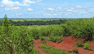
The South Cameroon Plateau lies between 2 and 6° N and 10 and 16° E. It covers about 225,100 km², more than half of Cameroon's total area. The plateau is characterised by sloping terrain and gently rolling hills. The altitude varies from 250 to 800 m and averages 600 or 650 m. The Western High PlateauWestern High Plateau
The Western High Plateau, Western Highlands, or Bamenda Grassfields is a region of Cameroon characterised by high relief, cool temperatures, heavy rainfall, and savanna vegetation. The region lies along the Cameroon line and consists of mountain ranges and volcanoes made of crystalline and igneous...
lies northwest of the plateau and separates it from the interior African plain. The Adamawa Plateau
Adamawa Plateau
The Adamawa Plateau is a plateau region in west-central Africa stretching from south-eastern Nigeria through north-central Cameroon to the Central African Republic. The plateau was named after Fulani Muslim leader Modibo Adama. The part of the plateau that lies in Nigeria is more popularly known...
lies to the plateau's north. From an altitude between 800 to 900 m. there, the plateau slowly slopes south and west from the region of Bedzare and Meiganga
Meiganga
Meiganga is a town in the Adamawa Province of Cameroon. It is located at around . Its estimated population in 2001 is 71,000....
.
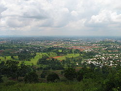
Yaoundé
-Transportation:Yaoundé Nsimalen International Airport is a major civilian hub, while nearby Yaoundé Airport is used by the military. Railway lines run west to the port city of Douala and north to N'Gaoundéré. Many bus companies operate from the city; particularly in the Nsam and Mvan neighborhoods...
(1,295 m), and Ntem massif near Ebolowa
Ebolowa
Ebolowa is the capital of Cameroon's South Province. It has a population of 79,500 . It is a colonial town and a notable agricultural centre.- Overview :The main crop is cocoa...
(1,400 m).
To the southeast, the transition to the Congo basin takes place on a gently sloping peneplain
Peneplain
A peneplain is a low-relief plain representing the final stage of fluvial erosion during times of extended tectonic stability. The existence of peneplains, and peneplanation as a geomorphological process, is not without controversy, due to a lack of contemporary examples and uncertainty in...
. The hills of the eastern portion are gentler than those of the west. These hills are known as half-oranges and can easily be seen in the area of Batouri
Batouri
Batouri is a town and commune in the East Province of Cameroon. It is the second largest municipality in the province after the provincial capital Bertoua. It is located on the main road connecting Bertoua to the Central African Republic and to the Cameroonian town of Yokadouma...
and Bélabo
Bélabo
Bélabo is a town and commune in Cameroon, lying on the Yaoundé – N'Gaoundéré railway line. Near the town lies the Sanaga-Yong chimpanzee rescue centre.- References :...
. The lowest point of the plateau is the Sangha River
Sangha River
The Sangha River, a river in central Africa, is a tributary of the Congo River, which it joins at . Formed by the merging of the Mambéré River into the Kadéï River at Nola , the Sangha flows through the Central African Republic, along the border of Cameroon, and through the Republic of Congo.Its...
valley in the southeast.
Geology
Metamorphic rockMetamorphic rock
Metamorphic rock is the transformation of an existing rock type, the protolith, in a process called metamorphism, which means "change in form". The protolith is subjected to heat and pressure causing profound physical and/or chemical change...
s such as gneiss
Gneiss
Gneiss is a common and widely distributed type of rock formed by high-grade regional metamorphic processes from pre-existing formations that were originally either igneous or sedimentary rocks.-Etymology:...
, mica
Mica
The mica group of sheet silicate minerals includes several closely related materials having highly perfect basal cleavage. All are monoclinic, with a tendency towards pseudohexagonal crystals, and are similar in chemical composition...
, migmatite
Migmatite
Migmatite is a rock at the frontier between igneous and metamorphic rocks. They can also be known as diatexite.Migmatites form under extreme temperature conditions during prograde metamorphism, where partial melting occurs in pre-existing rocks. Migmatites are not crystallized from a totally...
s, and schist
Schist
The schists constitute a group of medium-grade metamorphic rocks, chiefly notable for the preponderance of lamellar minerals such as micas, chlorite, talc, hornblende, graphite, and others. Quartz often occurs in drawn-out grains to such an extent that a particular form called quartz schist is...
s make up the South Cameroon Plateau's basement. Deposits of these rocks appear along fault lines
Geologic fault
In geology, a fault is a planar fracture or discontinuity in a volume of rock, across which there has been significant displacement along the fractures as a result of earth movement. Large faults within the Earth's crust result from the action of tectonic forces...
south of Yaoundé, where schists and quartzite
Quartzite
Quartzite is a hard metamorphic rock which was originally sandstone. Sandstone is converted into quartzite through heating and pressure usually related to tectonic compression within orogenic belts. Pure quartzite is usually white to gray, though quartzites often occur in various shades of pink...
s are found; near the Dja River
Dja River
The Dja River is a stream in west-central Africa. It forms part of Cameroon–Republic of Congo border and has a course of roughly 450 miles ....
, where limestone
Limestone
Limestone is a sedimentary rock composed largely of the minerals calcite and aragonite, which are different crystal forms of calcium carbonate . Many limestones are composed from skeletal fragments of marine organisms such as coral or foraminifera....
and schists occur; and along the Ntem River
Ntem River
The Ntem River is a border river in Cameroon, Equatorial Guinea and Gabon. It rises in Gabon, but flows into the Atlantic Ocean in Cameroon. A tributary continues along the border towards the east.- Towns :* Campo* Minvoul, Gabon...
, where gneiss, granite
Granite
Granite is a common and widely occurring type of intrusive, felsic, igneous rock. Granite usually has a medium- to coarse-grained texture. Occasionally some individual crystals are larger than the groundmass, in which case the texture is known as porphyritic. A granitic rock with a porphyritic...
, mica, migmatite, and schists occur. The plateau's western portions are made up primarily of gneiss. These rocks are millions of years old.
The plateau's soils are predominately ferrallitic and lateritic
Laterite
Laterites are soil types rich in iron and aluminium, formed in hot and wet tropical areas. Nearly all laterites are rusty-red because of iron oxides. They develop by intensive and long-lasting weathering of the underlying parent rock...
, the result of decomposing crystalline and sedimentary stone. The soil colour varies from red or reddish brown in the interior to yellow along the coast, where greater humidity causes a colour change. The soil is made up of decomposing crystalline rocks (granite, gneiss, schists, and michachists), or sedimentary rocks in the coastal area. Soils are deep, averaging 10 m., although they are thinner in the north, where rainy seasons are shorter. Ferrous
Ferrous
Ferrous , in chemistry, indicates a divalent iron compound , as opposed to ferric, which indicates a trivalent iron compound ....
deposits in the soil are quite hard and are used to make bricks. Constant leaching of silica
Silicon dioxide
The chemical compound silicon dioxide, also known as silica , is an oxide of silicon with the chemical formula '. It has been known for its hardness since antiquity...
by percolating water prevents the soils from being very productive without fertilisation.
Climate
Wet season
The the wet season, or rainy season, is the time of year, covering one or more months, when most of the average annual rainfall in a region occurs. The term green season is also sometimes used as a euphemism by tourist authorities. Areas with wet seasons are dispersed across portions of the...
, and two dry
Dry season
The dry season is a term commonly used when describing the weather in the tropics. The weather in the tropics is dominated by the tropical rain belt, which oscillates from the northern to the southern tropics over the course of the year...
. The long dry season is from December to March (or slightly longer in the northern reaches of the plateau), the short rainy season from March to June, the short dry season in August, and the long rainy season from September to December.
Rainfall averages 1,500–2,000 mm per year, and precipitation is common even during the dry seasons. However, rainfall is higher near the coast and in the south and diminishes toward the northeast. The coastal city Kribi, for example, receives 2,970 mm of rain each year, Moloundou
Moloundou
Moloundou is an arrondissement in the Boumba et Ngoko Division of southeastern Cameroon's East Province. Mouloundou is close to Boumba Bek and Nki National Parks on the Dja River...
in the southeast gets 1,502 mm, and Yoko
Yoko
- Female :Yōko is a female Japanese given name. Depending on the kanji used in writing it, it can have meanings including "Free Child" , "Sunny Child" , "Glorious Child" , "Ocean Child" , "Leaf Child" , etc....
gets 1,638 mm.
The temperature remains fairly steady year round, averaging 25°C. This fluctuates slightly with the seasons. The long, rainy season is the coldest time of year, and the long dry season is the warmest. Humidity is high year round.
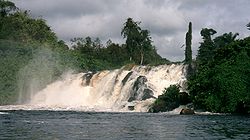
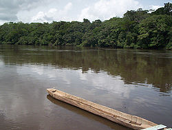
Drainage
Atlantic Ocean
The Atlantic Ocean is the second-largest of the world's oceanic divisions. With a total area of about , it covers approximately 20% of the Earth's surface and about 26% of its water surface area...
and the Congo River basin. The rivers south of the Sanaga
Sanaga River
The Sanaga River is a river of South Province, Cameroon, Centre Province, Cameroon, and West Province, Cameroon. Its length is 890 kilometers.The Sanaga River forms a boundary between two tropical moist forest ecoregions...
follow an equatorial regime; that is, they reach a high water point during the rainy seasons and a low point during the dry seasons. There, rivers such as the Dja
Dja River
The Dja River is a stream in west-central Africa. It forms part of Cameroon–Republic of Congo border and has a course of roughly 450 miles ....
, Boumba, and Sangha
Sangha River
The Sangha River, a river in central Africa, is a tributary of the Congo River, which it joins at . Formed by the merging of the Mambéré River into the Kadéï River at Nola , the Sangha flows through the Central African Republic, along the border of Cameroon, and through the Republic of Congo.Its...
have carved out valleys. The rivers flow slowly and experience seasonal flooding during the rainy season.
The Sanaga and rivers north of it follow a complex, or mixed, Sudano-Guinea regime because the territory they drain lies in both tropical
Tropical climate
A tropical climate is a climate of the tropics. In the Köppen climate classification it is a non-arid climate in which all twelve months have mean temperatures above...
and equatorial climate zones. This means that upstream, they follow a tropical regime, with high water during the long rainy season and low water during the long dry season. However, further south, they receive constant rainfall and flow steadily.
Flora and fauna
Dense vegetation covers the plateau, especially in the south. This includes vast tracts of rainforestRainforest
Rainforests are forests characterized by high rainfall, with definitions based on a minimum normal annual rainfall of 1750-2000 mm...
, which grows in three or four strata. The tallest trees are straight with buttress root
Buttress root
Buttress are large roots on all sides of a big bottomed tree or shallowly rooted tree. Typically, they are found in nutrient-poor rainforest soils and do not penetrate to deeper layers. They prevent the tree from falling over while also gathering more nutrients...
s and stand about 40 m tall. Below these stand thinner, shorter trees with large concentrations of leaves at their tops. The bottom layer is made up of undergrowth of saplings and grasses, although this layer is thin when the larger trees grow close together and block the sunlight. Tree species include azobé
Lophira alata
Lophira alata is a species of plant in the Ochnaceae family. It is found in Cameroon, the Republic of the Congo, the Democratic Republic of the Congo, Ivory Coast, Equatorial Guinea, Gabon, Ghana, Liberia, Nigeria, Sierra Leone, Sudan, and Uganda. Its natural habitat is subtropical or tropical...
, bubinga
Guibourtia
Guibourtia is a flowering plant genus in the family Fabaceae . It contains 16 species, native to tropical regions of Africa and South America...
, ebony
Ebony
Ebony is a dense black wood, most commonly yielded by several species in the genus Diospyros, but ebony may also refer to other heavy, black woods from unrelated species. Ebony is dense enough to sink in water. Its fine texture, and very smooth finish when polished, make it valuable as an...
, iroko, mahogany
Mahogany
The name mahogany is used when referring to numerous varieties of dark-colored hardwood. It is a native American word originally used for the wood of the species Swietenia mahagoni, known as West Indian or Cuban mahogany....
, and obeche. This primary rainforest exists in the plateau's south and east. Where human activities have affected the forest, for farming, timber, pasture, and urban growth, secondary growth has taken over as the forest has recovered. This is evident around Yaoundé.
Forest gradually gives way to Guinean savanna
Savanna
A savanna, or savannah, is a grassland ecosystem characterized by the trees being sufficiently small or widely spaced so that the canopy does not close. The open canopy allows sufficient light to reach the ground to support an unbroken herbaceous layer consisting primarily of C4 grasses.Some...
to the north. This consists of vast grasslands punctuated by trees. The savanna has increased as human activities have cut back the forest through activities such as burning.
The plateau's rainforests house large numbers of animal species. These include birds, monkeys, and snakes. Others are elephants, chimpanzees, and many rodents.