
South Aral Sea
Encyclopedia
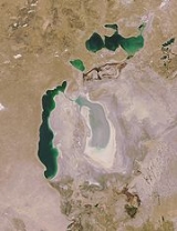
The South Aral Sea is a lake in the basin of the former Aral Sea
which formed in 1986 when that body divided in two, due to diversion of river inflow for agriculture. In 2003 the South Aral Sea itself split into western and eastern basins, the Eastern Sea and the Western Sea, connected by a narrow channel (channel bed at an elevation of 29 m (95 ft)) that balanced surface levels but did not allow mixing, and in 2005 the North Aral Sea
was dammed to prevent the collapse of its fisheries, cutting off the only remaining inflow to the southern lakes. In 2008 the Eastern Sea split again, and in May 2009 had completely dried out. In 2010, it was partially filled again by meltwater. The Western Sea has some replenishment from groundwater in the northwest, and so is likely to avoid desiccation.
began shrinking in the 1960s, when the Soviet Union
decided that the two rivers feeding it, the Amu Darya
and the Syr Darya
, would be diverted to irrigate
cotton
and food crops in Kazakhstan
and Uzbekistan
. In 1986, due to an accelerated loss of water, the Aral Sea was split into northern and southern parts; the northern part is the current North Aral Sea
.
of 70 g/l and the eastern basin 100 g/l. Once the water level falls below the connecting channel (elevation 29m), the salinities can be expected to diverge further. Under current conditions, the eastern basin may receive water from the Amu Darya
in wet years, fluctuating in salinity and flooding an area of up to 4500 km² in salt water to a depth of about one meter, which would preclude any economic activity in the area, while the western basin becomes increasingly saline. Water diversion from the Amu Darya directly to the deeper western basin could lower its salinity enough to allow resumption of local fisheries, while allowing the eastern basin to desiccate almost entirely and avoiding the problems of flooding.
Aral Sea
The Aral Sea was a lake that lay between Kazakhstan in the north and Karakalpakstan, an autonomous region of Uzbekistan, in the south...
which formed in 1986 when that body divided in two, due to diversion of river inflow for agriculture. In 2003 the South Aral Sea itself split into western and eastern basins, the Eastern Sea and the Western Sea, connected by a narrow channel (channel bed at an elevation of 29 m (95 ft)) that balanced surface levels but did not allow mixing, and in 2005 the North Aral Sea
North Aral Sea
The North Aral Sea is the portion of the former Aral Sea that is fed by the Syr Darya River. It split from the South Aral Sea in 1986 as water levels dropped due to river diversion for agriculture. The poorly built Dike Kokaral intended to contain the North Aral Sea and save its fisheries failed...
was dammed to prevent the collapse of its fisheries, cutting off the only remaining inflow to the southern lakes. In 2008 the Eastern Sea split again, and in May 2009 had completely dried out. In 2010, it was partially filled again by meltwater. The Western Sea has some replenishment from groundwater in the northwest, and so is likely to avoid desiccation.
Background
The Aral SeaAral Sea
The Aral Sea was a lake that lay between Kazakhstan in the north and Karakalpakstan, an autonomous region of Uzbekistan, in the south...
began shrinking in the 1960s, when the Soviet Union
Soviet Union
The Soviet Union , officially the Union of Soviet Socialist Republics , was a constitutionally socialist state that existed in Eurasia between 1922 and 1991....
decided that the two rivers feeding it, the Amu Darya
Amu Darya
The Amu Darya , also called Oxus and Amu River, is a major river in Central Asia. It is formed by the junction of the Vakhsh and Panj rivers...
and the Syr Darya
Syr Darya
The Syr Darya , also transliterated Syrdarya or Sirdaryo, is a river in Central Asia, sometimes known as the Jaxartes or Yaxartes from its Ancient Greek name . The Greek name is derived from Old Persian, Yakhsha Arta , a reference to the color of the river's water...
, would be diverted to irrigate
Irrigation
Irrigation may be defined as the science of artificial application of water to the land or soil. It is used to assist in the growing of agricultural crops, maintenance of landscapes, and revegetation of disturbed soils in dry areas and during periods of inadequate rainfall...
cotton
Cotton
Cotton is a soft, fluffy staple fiber that grows in a boll, or protective capsule, around the seeds of cotton plants of the genus Gossypium. The fiber is almost pure cellulose. The botanical purpose of cotton fiber is to aid in seed dispersal....
and food crops in Kazakhstan
Kazakhstan
Kazakhstan , officially the Republic of Kazakhstan, is a transcontinental country in Central Asia and Eastern Europe. Ranked as the ninth largest country in the world, it is also the world's largest landlocked country; its territory of is greater than Western Europe...
and Uzbekistan
Uzbekistan
Uzbekistan , officially the Republic of Uzbekistan is a doubly landlocked country in Central Asia and one of the six independent Turkic states. It shares borders with Kazakhstan to the west and to the north, Kyrgyzstan and Tajikistan to the east, and Afghanistan and Turkmenistan to the south....
. In 1986, due to an accelerated loss of water, the Aral Sea was split into northern and southern parts; the northern part is the current North Aral Sea
North Aral Sea
The North Aral Sea is the portion of the former Aral Sea that is fed by the Syr Darya River. It split from the South Aral Sea in 1986 as water levels dropped due to river diversion for agriculture. The poorly built Dike Kokaral intended to contain the North Aral Sea and save its fisheries failed...
.
Salinity
In 2007, the western basin had a salinitySalinity
Salinity is the saltiness or dissolved salt content of a body of water. It is a general term used to describe the levels of different salts such as sodium chloride, magnesium and calcium sulfates, and bicarbonates...
of 70 g/l and the eastern basin 100 g/l. Once the water level falls below the connecting channel (elevation 29m), the salinities can be expected to diverge further. Under current conditions, the eastern basin may receive water from the Amu Darya
Amu Darya
The Amu Darya , also called Oxus and Amu River, is a major river in Central Asia. It is formed by the junction of the Vakhsh and Panj rivers...
in wet years, fluctuating in salinity and flooding an area of up to 4500 km² in salt water to a depth of about one meter, which would preclude any economic activity in the area, while the western basin becomes increasingly saline. Water diversion from the Amu Darya directly to the deeper western basin could lower its salinity enough to allow resumption of local fisheries, while allowing the eastern basin to desiccate almost entirely and avoiding the problems of flooding.