

Sooke Flowline
Encyclopedia
The Sooke Flowline is an abandoned 44 kilometer (27 mi) concrete aqueduct
Aqueduct
An aqueduct is a water supply or navigable channel constructed to convey water. In modern engineering, the term is used for any system of pipes, ditches, canals, tunnels, and other structures used for this purpose....
that snakes through the Sooke Hills from Sooke Lake to the Humpback Reservoir near Mt. Wells Regional Park
Mount Wells Regional Park
Mount Wells is a regional park located northwest of the township of Langford and in the nearby vicinity of Goldstream Provincial Park and the Sooke Hills Regional Park Reserve. This park is a well kept secret and it is a weekend getaway for birdwatchers, hikers and rock climbers.The parking lot is...
. From this reservoir, a buried, riveted steel pressure main transported water to Victoria. In between 1994 and 2007, this main was replaced since it was long past its useful life. The flowline was vital to the continued growth of the City of Victoria
Victoria, British Columbia
Victoria is the capital city of British Columbia, Canada and is located on the southern tip of Vancouver Island off Canada's Pacific coast. The city has a population of about 78,000 within the metropolitan area of Greater Victoria, which has a population of 360,063, the 15th most populous Canadian...
as it provided a reliable water supply.
Elk Lake
Elk Lake (British Columbia)
Elk Lake is a large lake located in Elk/Beaver Lake Regional Park in Saanich, British Columbia. Elk Lake and Beaver Lake are actually one lake as a shallow channel connects them....
used to be the water supply for Victoria and when the Colquitz River was dammed, it merely flooded the swamp and merged Elk and Beaver Lakes. Unfortunately the intake was at the swampy, shallow end of the reservoir. In the early 1900s, it was determined that Elk/Beaver Lake could no longer meet Victoria's water needs. The daily draw from the lake was just too great and despite measures taken to buy time, such as filter ponds, the pressure and supply was too little and sediment
Sediment
Sediment is naturally occurring material that is broken down by processes of weathering and erosion, and is subsequently transported by the action of fluids such as wind, water, or ice, and/or by the force of gravity acting on the particle itself....
and amphibians were getting drawn out through the lake's intake.
Construction
During the year of 1912, the city expropriated 40 property owners on Sooke Lake and on the proposed flowline right-of-way (ROW) at great cost. The city hired the Pacific Lock Joint Pipe Company to cast the pipe segments and using their patented design, constructed the pipeline. In between 1911–1915, this major engineering project employed over 400 workers and housed their families in rural Sooke. The pipe is almost completely at a constant elevation. Although figures vary, the slope from Sooke Lake to Humpback is between 0.0947% and 0.119% when the inverted siphonsSiphon
The word siphon is sometimes used to refer to a wide variety of devices that involve the flow of liquids through tubes. But in the English language today, the word siphon usually refers to a tube in an inverted U shape which causes a liquid to flow uphill, above the surface of the reservoir,...
are excluded.
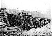
At the factory located at Coopers Cove, at the site of today's Fuse Bar and Grill, round concrete segments, 36,000 in all, were mass produced. The engineering firm, Sanderson and Porter, specified 40-inch pipe, but the company already had 42-inch molds made up so they decided to use them instead. The factory was very efficient and used steam to accelerate the curing of the concrete segments. In one 8-hour shift, 150-160 segments were produced. The segments were winched up the hill 450 feet above the construction site.Three small locomotives were used to bring segments to both ends via a temporary 2-foot gauge railway and the pipe was constructed from the ends to the midpoint. At the ends, tripod derricks would unload the segments and placed them on the crushed railbed while the tracks were removed. All trees on the 100 ft right of way were cleared so that they could not fall and crush the pipe.
Maintenance
During the flowline's operation, caretakers lived along the route in small cabins; many of which are still there today. They rode recumbent tricycles on the pipe with tilted rear wheels to stay on top. During their routes they were on the lookout for cracks in the pipe, leaky joints and trespassers.Every 600 metres (550 yards) or so there are access hatches. These were meant for periodic maintenance from the inside by workers. A man would lie prone on a cart and scrape moss off the inside of the pipe and clear sediments, rocks and dead fish which inevitably backed up in places. Placed on top of these hatches were wire mesh domes, which reduced pressure build up and helped aerate the water.
Decommissioning
The flowline was never great efficiency wise. When the taps were opened in 1915, the water which came through was high quality, but they soon discovered that they were experiencing a 50-75% water loss throughout its length, depending on the season and temperature. During summer however, the leaking was slightly reduced. This needed to be remedied by placing strips of material across the joints and fastening them with iron bands. A further challenge experienced was that the winter of 1915-16 was one of the worst in history. Parts of the newly constructed pipe got taken out by landslides and repair was difficult since the construction railway no longer existed. When the city began to outgrow the demand, the pipe section from Sooke to the Humpback Reservoir was decommissioned in 1970. The pipe had begun to show its age with many leaks and damage from falling trees and rocks. This was then replaced with the 8.8 km (5.5 mi) Kapoor TunnelKapoor tunnel
The Kapoor Tunnel is a straight subterranean route which is currently the main transport of water from the Sooke Lake to the Westshore, City of Victoria, Esquimalt, and the Saanich Peninsula. When it was determined that the Sooke Flowline would no longer meet the region's needs, the decision was...
bored through solid rock to the Japan Gulch Disinfection Plant near Goldstream Provincial Park
Goldstream Provincial Park
Goldstream Provincial Park is a provincial park in British Columbia, Canada. It is known for the annual fall salmon runs in the Goldstream River, and the large numbers of bald eagles that congregate to feed at that time. The total size of the park is 3.79 square kilometres. It is located in the...
.
Sooke Use
The portion of the old pipe from Sooke Lake to Sooke remained in service after the Humpback Reservoir section was decommissioned. This portion was routinely patrolled to make sure marijuanaCannabis (drug)
Cannabis, also known as marijuana among many other names, refers to any number of preparations of the Cannabis plant intended for use as a psychoactive drug or for medicinal purposes. The English term marijuana comes from the Mexican Spanish word marihuana...
grow ops weren't tapping into the pipe and to do periodic patching up as best as possible, but it still had many leaks. Damage had also resulted from falling rocks and trees and there were concerns whether it could survive a major earthquake. The pipe by nature is fireproof. Finally in late 2009 it was replaced with a PVC
Polyvinyl chloride
Polyvinyl chloride, commonly abbreviated PVC, is a thermoplastic polymer. It is a vinyl polymer constructed of repeating vinyl groups having one hydrogen replaced by chloride. Polyvinyl chloride is the third most widely produced plastic, after polyethylene and polypropylene. PVC is widely used in...
pipe buried under the Galloping Goose Regional Trail. It connects to the Sooke River Road Disinfection Facility which went online in 2009. The facility incorporates ultraviolet disinfection (UV), and is followed by the addition of chlorine and ammonia.
The water department of the Capital Regional District still owns pipe and the approximately 100 ft (30.5 m) wide corridor which includes large trees, cliffs, mossy bluffs which is some of the most beautiful scenery around.
Materials
There are 54 trestles along the 44 km (27 mi) length of various sizes spanning ravines. During construction, temporary timber trestles were built alongside the proposed trestles to avoid construction delays and speed up construction of the permanent concrete trestles.The majority of the pipeline consists of reinforced concrete
Concrete
Concrete is a composite construction material, composed of cement and other cementitious materials such as fly ash and slag cement, aggregate , water and chemical admixtures.The word concrete comes from the Latin word...
segments which are four by four feet.
Six concrete trestles are made out of wood staves
Woodstave
Woodstave is a common usage of a specific construction material made from wood. The form of the wood is in staves similar to the construction of a wooden barrel as manufactured by coopers of early years. Woodstave was commonly used in the construction of large vessels to contain and/or transport...
preserved with creosote
Creosote
Creosote is the portion of chemical products obtained by the distillation of a tar that remains heavier than water, notably useful for its anti-septic and preservative properties...
and bound with iron
Iron
Iron is a chemical element with the symbol Fe and atomic number 26. It is a metal in the first transition series. It is the most common element forming the planet Earth as a whole, forming much of Earth's outer and inner core. It is the fourth most common element in the Earth's crust...
bands. These were built to reduce the length around the longest of ravines. The wooden trestles actually dip down one side of the ravine
Ravine
A ravine is a landform narrower than a canyon and is often the product of streamcutting erosion. Ravines are typically classified as larger in scale than gullies, although smaller than valleys. A ravine is generally a fluvial slope landform of relatively steep sides, on the order of twenty to...
and go up the other relying on the downward pressure to push the water back up. These "dipping" trestles, known as "inverted siphons," were initially constructed of concrete as well but the material is very weak in tension and resulted in cracked segments due to the pressure of 39.017 psi
Pounds per square inch
The pound per square inch or, more accurately, pound-force per square inch is a unit of pressure or of stress based on avoirdupois units...
(abs
Pressure measurement
Many techniques have been developed for the measurement of pressure and vacuum. Instruments used to measure pressure are called pressure gauges or vacuum gauges....
).
There is also one metal trestle over Ayum Creek near Sooke.
Heritage Protection
At this time, there is currently no heritage protection on this structure. There is a concern from CRD waterworks that the flowline could be a liability risk. There is a growing movement to have heritage protection put on the pipe and have it transferred to CRD Regional Parks. Other notable examples of heritage protection include the concrete slabs that comprise Benvenuto Avenue which leads down to Butchart GardensButchart Gardens
The Butchart Gardens is a group of floral display gardens in Brentwood Bay, British Columbia, Canada, located near Victoria on Vancouver Island. The gardens receive more than a million visitors each year...
in Brentwood Bay, British Columbia
Brentwood Bay, British Columbia
Brentwood Bay, is a small neighbourhood in the municipality of Central Saanich, on the Saanich Peninsula. It lies north of the city of Victoria and south of Sidney on the southern tip of Vancouver Island. Situated on the Saanich Inlet, it includes the Butchart Gardens, the Victoria Butterfly...
.
The Sooke Museum
As a pilot project of the Sooke Museum, surplus sections of pipe were laid out at multiple locations around the Sooke townsite accompanied by interpretive signs and historical photographs. One issue that had to be addressed is that there was still asbestos on the pipe which was used in the mortar to join the pipe segments together.These segments can be found at the following locations:
- Sooke Museum grounds on Phillips Road
- In front of Home Hardware on Sooke Road
- Holy Trinity Church on Murray Road
- Sooke Municipal Hall on Otter Point Road
Utility Box Beautification
As a part of a beautification project around the CRD, plain, boring electrical boxes were outfitted with decorative images of the pipe trestles. Such examples are at the following locations:- Helmcken Road and Watkiss Way in View RoyalView Royal, British ColumbiaView Royal is a town in Greater Victoria and a member municipality of the Capital Regional District of British Columbia, Canada. View Royal has a population of approximately 8000 residents and was incorporated as a municipality in December 1988....
. - Veteran's Memorial Parkway at the E&N crossing in Langford.
- Lansdowne and Foul Bay Roads in Oak BayOak Bay, British ColumbiaOak Bay is a municipality located on the southern tip of Vancouver Island, in the Canadian Province of British Columbia, Canada. A member municipality of the Capital Regional District, it is a community east of and adjacent to the City of Victoria...
. - Bay and Pleasant Street in VictoriaVictoria, British ColumbiaVictoria is the capital city of British Columbia, Canada and is located on the southern tip of Vancouver Island off Canada's Pacific coast. The city has a population of about 78,000 within the metropolitan area of Greater Victoria, which has a population of 360,063, the 15th most populous Canadian...
.
Parks
In the Sooke Parks Municipal Plan, a trail on top of the flowline within the Sooke municipal boundaries is in one of their proposed plans. The ROW also travels through Mount Wells Regional Park, Sooke Hills Wilderness Regional Park, Allman Park, Sooke Potholes Regional Park, and the Sea to Sea Green-Blue Belt Regional Park. The goal is the have the whole line encompassed within a park.Access
The pipe can be found and accessed at the following locations:- Mt. Wells Regional Park - the pipe terminus is at the Humpback Reservoir (Mt. Wells Parking lot) and it twins Humpback Road to the Sooke Highway. - Parking is located by some mailboxes 300m (330 yards) south of indicated location. - Glinz Lake Road - drive up the road and park just before the Camp Thunderbird main gate. The pipe crosses the road approximately 50m (55 yards) south of the gate. - Impala Road - this steep road is best if it's walked up. There is no room to park up the road. - Harbourview Road - there is a CRD parking lot at the end. Continue walking up the road for 15 minutes where you will see the pipe cross. - Sooke Potholes - the pipe runs north-south to the east of the Sooke River.
Traversing
The pipe was not meant to be walked on as a trail and some parts could be dangerous. The CRD's current position is that walking on the pipe is done at one's own risk and is discouraged.Leechtown - Sooke Potholes - Charters Creek
This portion is easily traveled as it is in a drier climate; it is more exposed to sun, which has limited mossMoss
Mosses are small, soft plants that are typically 1–10 cm tall, though some species are much larger. They commonly grow close together in clumps or mats in damp or shady locations. They do not have flowers or seeds, and their simple leaves cover the thin wiry stems...
growth. The lack of moss actually makes the pipe more slippery. There are few blow-downs but otherwise is easily passable. There are a few aqueducts in this part, as well as the four-storey one, which should be crossed with utmost care or not crossed at all. There is a cantilever
Cantilever
A cantilever is a beam anchored at only one end. The beam carries the load to the support where it is resisted by moment and shear stress. Cantilever construction allows for overhanging structures without external bracing. Cantilevers can also be constructed with trusses or slabs.This is in...
ed gangway
Walkway
In US English, a walkway is a composite or umbrella term for all engineered surfaces or structures which support the use of trails. These include sidewalks, footbridges, stiles, stairs, ramps, paseos or tunnels...
on the side which can be utilized however they are beginning to show their age and may no longer be safe.
Charters Creek - Harbourview Road ( Not recommended)
At Charters creek there is the disinfection plant for Sooke as well as the biggest inverted siphon. After Sooke switched to the new pressure main, the flowing water poured into Charters Creek for salmonSalmon
Salmon is the common name for several species of fish in the family Salmonidae. Several other fish in the same family are called trout; the difference is often said to be that salmon migrate and trout are resident, but this distinction does not strictly hold true...
habitat enhancement but this project was later discontinued. There are no more gangways on the aqueducts beyond this point. From the north side, it is easy to get down as there is a service road but the south side is difficult and not well traveled. The embankment is loose and beyond that the pipe is quite overgrown. A path can be pushed through and tools would be of aid to clear a path. As the walk gets closer to Harbourview Road, the pipe opens up due to this part being frequented by mountain bikers. There is a really tall aqueduct here as well which crosses a logging road. A fall could be potentially deadly.
Harbourview Road - Glinz Lake Road
This is probably the easiest segment to walk along. The pipe is very open and there are not too many trestles to cross. There is an inverted siphon in disrepair very close to Harbourview Road but it can be bypassed by an existing deer trail. Like many segments, this part is quite scenic but it passes through a quarryQuarry
A quarry is a type of open-pit mine from which rock or minerals are extracted. Quarries are generally used for extracting building materials, such as dimension stone, construction aggregate, riprap, sand, and gravel. They are often collocated with concrete and asphalt plants due to the requirement...
site, which takes away from the walk.
Glinz Lake Road - Impala Road
Most people would likely agree that this is the most beautiful part of the pipeline walk. There are expanses of mossy bluffs, large trees and gorgeous views. There are three concrete trestles which are easily crossed as well as an inverted siphon which requires a bushwack to get around. Impala Road should not be driven up as the road is very steep, unpaved, and has no parking at the top.Impala Road - Mt. Wells Regional Park
Not much is known about this section besides the fact that it is the most urban. The flowline passes quite close to the back yards of residences and some homeowners have even claimed the pipe corridor as their own, which is not the case. Some people may object, but you are on public land as long as you stay on the pipe. Much of this section is also nearly impassible due to overgrowth of vegetation.External links
- http://sooke.ca/assets/Local~Government/Planning/Parks_March2009.pdf#search=%22flowline%22- The Sooke Parks Master Plan
- http://unknownvictoria.blogspot.com/2009/04/drop-to-drink.html- an article about the Sooke Lake water supply by Victoria's Ross Crockford
- http://www.scribd.com/full/39868988?access_key=key-14fwt5vp0bixfqg4rm14- A PowerPoint about the Sooke Flowline's historical significance