
Snowflake, Arizona
Encyclopedia
Snowflake is a town in Navajo County
, Arizona
, United States
. It was founded in 1878 by Erastus Snow
and William Jordan Flake
, Mormon pioneers and colonizers. According to 2006 Census Bureau estimates, the population of the town is 4,958.
Snowflake is 25 miles south of Interstate 40
(formerly U.S. Route 66
) via Highway 77. The Apache Railway provides freight service.
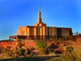
Recently, the town and surrounding area have experienced steady growth, primarily to the east, west and south. An additional 9-holes were added to the 18-hole golf course where the Snowflake Arizona Temple
was built by The Church of Jesus Christ of Latter-day Saints in 2002. To the east of town, a substantial community of individuals suffering from multiple chemical sensitivity
syndrome has grown since the 1980s.
Snowflake experiences a four season climate with a warm (sometimes hot) summer, mild autumn, mild to cold winter and cool, windy spring. Typical high temperatures hover around 90 °F (32.2 °C) during July and August and 30 to 55 °F (12.8 °C) in December/January.
According to the United States Census Bureau
, the town has a total area of 30.9 square miles (80 km²), of which, 30.8 square miles (79.8 km²) of it is land and 0.1 square mile (0.258998811 km²) of it (0.16%) is water.
of 2000, there were 4,460 people, 1,312 households, and 1,070 families residing in the town. The population density
was 144.8 people per square mile (55.9/km²). There were 1,536 housing units at an average density of 49.9 per square mile (19.2/km²). The racial makeup of the town was 87.24% White
, 0.27% Black
or African American
, 6.93% Native American
, 0.49% Asian
, 0.07% Pacific Islander
, 3.00% from other races
, and 2.00% from two or more races. 8.05% of the population were Hispanic
or Latino
of any race.
There were 1,312 households out of which 46.5% had children under the age of 18 living with them, 69.5% were married couples
living together, 9.1% had a female householder with no husband present, and 18.4% were non-families. 15.8% of all households were made up of individuals and 6.7% had someone living alone who was 65 years of age or older. The average household size was 3.37 and the average family size was 3.81.
In the town the population was spread out with 37.9% under the age of 18, 9.8% from 18 to 24, 21.8% from 25 to 44, 19.8% from 45 to 64, and 10.7% who were 65 years of age or older. The median age was 28 years. For every 100 females there were 99.7 males. For every 100 females age 18 and over, there were 95.3 males.
The median income for a household in the town was $37,439, and the median income for a family was $42,500. Males had a median income of $30,517 versus $21,164 for females. The per capita income
for the town was $13,391. About 10.4% of families and 15.0% of the population were below the poverty line, including 18.7% of those under age 18 and 14.1% of those age 65 or over.
. Taylor Elementary School in the neighboring town of Taylor, Arizona
is also part of the Snowflake Unified school District.
Northland Pioneer College
's Silver Creek campus extension is located in Snowflake.
Navajo County, Arizona
-2010:Whereas according to the 2010 U.S. Census Bureau:*49.3% White*0.9% Black*43.4% Native American*0.5% Asian*0.1% Native Hawaiian or Pacific Islander*2.5% Two or more races*3.3% Other races*10.8% Hispanic or Latino -2000:...
, Arizona
Arizona
Arizona ; is a state located in the southwestern region of the United States. It is also part of the western United States and the mountain west. The capital and largest city is Phoenix...
, United States
United States
The United States of America is a federal constitutional republic comprising fifty states and a federal district...
. It was founded in 1878 by Erastus Snow
Erastus Snow
Erastus Fairbanks Snow , born in St. Johnsbury, Vermont, was a member of the Quorum of the Twelve Apostles of The Church of Jesus Christ of Latter-day Saints from 1849 to 1888. Snow was also a leading figure in Mormon colonization of Arizona, Colorado, and New Mexico.Snow Canyon State Park Erastus...
and William Jordan Flake
William J. Flake
William Jordan Flake was a prominent member of The Church of Jesus Christ of Latter-day Saints, who helped settle parts of Arizona, and was imprisoned for polygamy.- Biography :William Flake was born in North Carolina...
, Mormon pioneers and colonizers. According to 2006 Census Bureau estimates, the population of the town is 4,958.
Snowflake is 25 miles south of Interstate 40
Interstate 40
Interstate 40 is the third-longest major east–west Interstate Highway in the United States, after I-90 and I-80. Its western end is at Interstate 15 in Barstow, California; its eastern end is at a concurrency of U.S. Route 117 and North Carolina Highway 132 in Wilmington, North Carolina...
(formerly U.S. Route 66
U.S. Route 66
U.S. Route 66 was a highway within the U.S. Highway System. One of the original U.S. highways, Route 66 was established on November 11, 1926 -- with road signs erected the following year...
) via Highway 77. The Apache Railway provides freight service.
Recently, the town and surrounding area have experienced steady growth, primarily to the east, west and south. An additional 9-holes were added to the 18-hole golf course where the Snowflake Arizona Temple
Snowflake Arizona Temple
The Snowflake Arizona Temple is the 108th operating temple of The Church of Jesus Christ of Latter-day Saints.Mormon pioneers first settled Snowflake, Arizona in 1878 at the request of LDS Church President Brigham Young. The town of Snowflake was named after William J...
was built by The Church of Jesus Christ of Latter-day Saints in 2002. To the east of town, a substantial community of individuals suffering from multiple chemical sensitivity
Multiple chemical sensitivity
Multiple chemical sensitivity is a chronic medical condition characterized by symptoms the affected person attributes to exposure to low levels of chemicals. Commonly suspected substances include smoke, pesticides, plastics, synthetic fabrics, scented products, petroleum products and paints...
syndrome has grown since the 1980s.
Snowflake experiences a four season climate with a warm (sometimes hot) summer, mild autumn, mild to cold winter and cool, windy spring. Typical high temperatures hover around 90 °F (32.2 °C) during July and August and 30 to 55 °F (12.8 °C) in December/January.
Geography
Snowflake is located at 34°30′40"N 110°4′59"W (34.511187, -110.082974).According to the United States Census Bureau
United States Census Bureau
The United States Census Bureau is the government agency that is responsible for the United States Census. It also gathers other national demographic and economic data...
, the town has a total area of 30.9 square miles (80 km²), of which, 30.8 square miles (79.8 km²) of it is land and 0.1 square mile (0.258998811 km²) of it (0.16%) is water.
Demographics
As of the censusCensus
A census is the procedure of systematically acquiring and recording information about the members of a given population. It is a regularly occurring and official count of a particular population. The term is used mostly in connection with national population and housing censuses; other common...
of 2000, there were 4,460 people, 1,312 households, and 1,070 families residing in the town. The population density
Population density
Population density is a measurement of population per unit area or unit volume. It is frequently applied to living organisms, and particularly to humans...
was 144.8 people per square mile (55.9/km²). There were 1,536 housing units at an average density of 49.9 per square mile (19.2/km²). The racial makeup of the town was 87.24% White
Race (United States Census)
Race and ethnicity in the United States Census, as defined by the Federal Office of Management and Budget and the United States Census Bureau, are self-identification data items in which residents choose the race or races with which they most closely identify, and indicate whether or not they are...
, 0.27% Black
Race (United States Census)
Race and ethnicity in the United States Census, as defined by the Federal Office of Management and Budget and the United States Census Bureau, are self-identification data items in which residents choose the race or races with which they most closely identify, and indicate whether or not they are...
or African American
Race (United States Census)
Race and ethnicity in the United States Census, as defined by the Federal Office of Management and Budget and the United States Census Bureau, are self-identification data items in which residents choose the race or races with which they most closely identify, and indicate whether or not they are...
, 6.93% Native American
Race (United States Census)
Race and ethnicity in the United States Census, as defined by the Federal Office of Management and Budget and the United States Census Bureau, are self-identification data items in which residents choose the race or races with which they most closely identify, and indicate whether or not they are...
, 0.49% Asian
Race (United States Census)
Race and ethnicity in the United States Census, as defined by the Federal Office of Management and Budget and the United States Census Bureau, are self-identification data items in which residents choose the race or races with which they most closely identify, and indicate whether or not they are...
, 0.07% Pacific Islander
Race (United States Census)
Race and ethnicity in the United States Census, as defined by the Federal Office of Management and Budget and the United States Census Bureau, are self-identification data items in which residents choose the race or races with which they most closely identify, and indicate whether or not they are...
, 3.00% from other races
Race (United States Census)
Race and ethnicity in the United States Census, as defined by the Federal Office of Management and Budget and the United States Census Bureau, are self-identification data items in which residents choose the race or races with which they most closely identify, and indicate whether or not they are...
, and 2.00% from two or more races. 8.05% of the population were Hispanic
Race (United States Census)
Race and ethnicity in the United States Census, as defined by the Federal Office of Management and Budget and the United States Census Bureau, are self-identification data items in which residents choose the race or races with which they most closely identify, and indicate whether or not they are...
or Latino
Race (United States Census)
Race and ethnicity in the United States Census, as defined by the Federal Office of Management and Budget and the United States Census Bureau, are self-identification data items in which residents choose the race or races with which they most closely identify, and indicate whether or not they are...
of any race.
There were 1,312 households out of which 46.5% had children under the age of 18 living with them, 69.5% were married couples
Marriage
Marriage is a social union or legal contract between people that creates kinship. It is an institution in which interpersonal relationships, usually intimate and sexual, are acknowledged in a variety of ways, depending on the culture or subculture in which it is found...
living together, 9.1% had a female householder with no husband present, and 18.4% were non-families. 15.8% of all households were made up of individuals and 6.7% had someone living alone who was 65 years of age or older. The average household size was 3.37 and the average family size was 3.81.
In the town the population was spread out with 37.9% under the age of 18, 9.8% from 18 to 24, 21.8% from 25 to 44, 19.8% from 45 to 64, and 10.7% who were 65 years of age or older. The median age was 28 years. For every 100 females there were 99.7 males. For every 100 females age 18 and over, there were 95.3 males.
The median income for a household in the town was $37,439, and the median income for a family was $42,500. Males had a median income of $30,517 versus $21,164 for females. The per capita income
Per capita income
Per capita income or income per person is a measure of mean income within an economic aggregate, such as a country or city. It is calculated by taking a measure of all sources of income in the aggregate and dividing it by the total population...
for the town was $13,391. About 10.4% of families and 15.0% of the population were below the poverty line, including 18.7% of those under age 18 and 14.1% of those age 65 or over.
In popular culture
- The logging crew involved in the Travis Walton abduction incident lived in this town, and several events surrounding that incident happened here. These events were dramatized in the 1993 science fiction film Fire in the SkyFire in the SkyFire in the Sky is a 1993 film based on an alleged extraterrestrial encounter, directed by Robert Lieberman, and written by Tracy Tormé based on Travis Walton's book The Walton Experience. The film stars Robert Patrick in the leading role as Walton's best friend and future brother-in-law, Mike...
. - References to Snowflake are made in the 2001 murder mystery Brigham City, and the 2004 war filmWar filmWar films are a film genre concerned with warfare, usually about naval, air or land battles, sometimes focusing instead on prisoners of war, covert operations, military training or other related subjects. At times war films focus on daily military or civilian life in wartime without depicting battles...
Saints and SoldiersSaints and SoldiersSaints and Soldiers is a 2003 drama-war film featuring Corbin Allred, Alexander Niver, Kirby Heyborne, Lawrence Bagby and Peter Holden.It is based loosely around events taking place shortly after the Malmedy massacre during the Battle of the Bulge where several US soldiers and a downed British...
. - A character named Jonah Flake appears in Armistead MaupinArmistead MaupinArmistead Jones Maupin, Jr. is an American writer, best known for his Tales of the City series of novels, based in San Francisco.-Early life:...
's Mary Ann in AutumnMary Ann in AutumnMary Ann in Autumn is the eighth book in the Tales of the City series by San Francisco novelist Armistead Maupin. It was released on November 2, 2010....
, a Tales of the CityTales of the CityTales of the City refers to a series of eight novels written by American author Armistead Maupin. The stories from Tales were originally serialized prior to their novelization, with the first four titles appearing as regular installments in the San Francisco Chronicle, while the fifth appeared in...
novel published in 2010. Jonah is from Snowflake and says he is a descendant of the Flake family that helped found the city.
Education
Snowflake is a part of the Snowflake Unified School District, consisting of Highland Primary School, Snowflake Intermediate School, Snowflake Junior High, and Snowflake High SchoolSnowflake High School
Snowflake High School is one of the oldest schools in Arizona. It was founded in the late 19th century for the education of Snowflake’s youth. The school is relatively small with its larger buildings connected by outdoor halls....
. Taylor Elementary School in the neighboring town of Taylor, Arizona
Taylor, Arizona
Taylor is a town in Navajo County, Arizona, United States. It was founded by Mormon settlers in January 1878, several months before the neighboring community of Snowflake, Arizona...
is also part of the Snowflake Unified school District.
Northland Pioneer College
Northland Pioneer College
Northland Pioneer College is a regionally accredited, publicly supported, comprehensive community college serving a large and diverse area in Navajo County, Arizona...
's Silver Creek campus extension is located in Snowflake.
Further reading
- Bernstein, Fred (2005). "In One Arizona Community, an Oasis in a Toxic World". The New York Times, July 10.