
Sistema Central
Encyclopedia
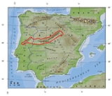
The Sistema Central is one of the main systems of mountain range
Mountain range
A mountain range is a single, large mass consisting of a succession of mountains or narrowly spaced mountain ridges, with or without peaks, closely related in position, direction, formation, and age; a component part of a mountain system or of a mountain chain...
s in the Iberian Peninsula
Iberian Peninsula
The Iberian Peninsula , sometimes called Iberia, is located in the extreme southwest of Europe and includes the modern-day sovereign states of Spain, Portugal and Andorra, as well as the British Overseas Territory of Gibraltar...
.
Description
The Sistema Central is a primary feature of the Meseta Central, the inner Iberian plateau, splitting the meseta into two parts. The Sistema Central runs in a ENE - WSW direction roughly along the southern border of the Spanish autonomous communityAutonomous communities of Spain
An autonomous community In other languages of Spain:*Catalan/Valencian .*Galician .*Basque . The second article of the constitution recognizes the rights of "nationalities and regions" to self-government and declares the "indissoluble unity of the Spanish nation".Political power in Spain is...
of Castile and León
Castile and León
Castile and León is an autonomous community in north-western Spain. It was so constituted in 1983 and it comprises the historical regions of León and Old Castile...
and Extremadura
Extremadura
Extremadura is an autonomous community of western Spain whose capital city is Mérida. Its component provinces are Cáceres and Badajoz. It is bordered by Portugal to the west...
continuing into the Guarda and Castelo Branco districts in Portugal
Portugal
Portugal , officially the Portuguese Republic is a country situated in southwestern Europe on the Iberian Peninsula. Portugal is the westernmost country of Europe, and is bordered by the Atlantic Ocean to the West and South and by Spain to the North and East. The Atlantic archipelagos of the...
.
Unlike the Sistema Ibérico, the Sistema Central range is a quite homogeneous system. It consists of several ranges that formed 25 million years ago as part of the Alpine orogeny
Alpine orogeny
The Alpine orogeny is an orogenic phase in the Late Mesozoic and Tertiary that formed the mountain ranges of the Alpide belt...
.
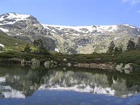
The major mountain ranges are the Sierra de Guadarrama
Sierra de Guadarrama
The Sierra de Guadarrama is a mountain range forming the main eastern section of the Sistema Central, the system of mountain ranges at the centre of the Iberian Peninsula. It is located between the Sierra de Gredos in the province of Ávila, and Sierra de Ayllón in the province of Guadalajara...
, which runs approximately along the border of the Madrid
Madrid
Madrid is the capital and largest city of Spain. The population of the city is roughly 3.3 million and the entire population of the Madrid metropolitan area is calculated to be 6.271 million. It is the third largest city in the European Union, after London and Berlin, and its metropolitan...
and Castile and León autonomous communities, the Sierra de Gredos
Sierra de Gredos
The Sierra de Gredos is a mountain range in the centre of the Iberian Peninsula, located between Ávila, Cáceres, Madrid and Toledo. It has been declared a regional park. Its highest point is Pico Almanzor, at 2,592 metres....
north of the border between Castile and León and Castile-La Mancha
Castile-La Mancha
Castile-La Mancha is an autonomous community of Spain. Castile-La Mancha is bordered by Castile and León, Madrid, Aragon, Valencia, Murcia, Andalusia, and Extremadura. It is one of the most sparsely populated of Spain's autonomous communities...
stretching into Extremadura
Extremadura
Extremadura is an autonomous community of western Spain whose capital city is Mérida. Its component provinces are Cáceres and Badajoz. It is bordered by Portugal to the west...
and containing the range's highest mountain, Pico Almanzor
Pico Almanzor
Pico Almanzor is the highest mountain in central Spain. Situated in the Sierra de Gredos in the province of Ávila, Almanzor is high. It is made of granite. The mountain is also known as Pico de Almanzor and Moro Almanzor.-History:...
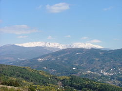
, at 2,592 m, as well as the Serra da Estrela, containing the highest point in continental Portugal
Portugal
Portugal , officially the Portuguese Republic is a country situated in southwestern Europe on the Iberian Peninsula. Portugal is the westernmost country of Europe, and is bordered by the Atlantic Ocean to the West and South and by Spain to the North and East. The Atlantic archipelagos of the...
, A Torre, 1.993 m.
"Sistema Central" is a widely-known academic geographical term. Local inhabitants, however, generally refer to the Sistema Central by the names of its smaller constituent ranges.
Mountain ranges
Amongst the main ranges of the Sistema Central from east to west are the following (highest points between brackets):- Serra da Estrela, (TorreTorre (Serra da Estrela)Torre is a monument that marks the highest point of Mainland Portugal, and the second most elevated of the Portuguese Republic . This point is not a distinctive mountain summit, but rather the highest point in a mountain range...
, 1.993 m). - Sierra de GataSierra de GataSierra de Gata is a mountain range in the Sistema Central, Spain. The highest point is Peña Canchera .-Description:The Sierra de Gata is located in the northwest of the province of Cáceres, which is in the autonomous community of Extremadura...
, (Jálama, 1.492 m). - Sierra de FranciaSierra de FranciaThe Sierra de Francia is a mountain range located at the southern end of province of Salamanca, Castile and León, Spain. It is located about 70 km from Salamanca city, the provincial capital....
, (Pico de la Hastiala, 1.735 m). - Sierra de Béjar, (Canchal de la Ceja, 2.430 m).
- Sierra de GredosSierra de GredosThe Sierra de Gredos is a mountain range in the centre of the Iberian Peninsula, located between Ávila, Cáceres, Madrid and Toledo. It has been declared a regional park. Its highest point is Pico Almanzor, at 2,592 metres....
, (Pico AlmanzorPico AlmanzorPico Almanzor is the highest mountain in central Spain. Situated in the Sierra de Gredos in the province of Ávila, Almanzor is high. It is made of granite. The mountain is also known as Pico de Almanzor and Moro Almanzor.-History:...
, 2.592 m). - Sierra de la Horcajada, (Risco de la Umbrela, 1.562 m).
- Sierra de Villafranca, (Cerro Moros, 2.059 m).
- Sierra de Piedra Aguda, (Piedra Aguda, 1.817 m).
- La Serrota, (Cerro del Santo, 2.294 m).
- Sierra de Hoyocasero, (Navasolana, 1.708 m).
- Sierra de la Paramera, (Pic Zapatero, 2.160 m).
- Sierra de ÁvilaSierra de ÁvilaThe Sierra de Ávila is a mountain range in the centre of the Iberian Peninsula. Its highest point is Cerro de Gorría, at 1727 metres....
, (Cerro de Gorría, 1.727 m). - Sierra de Ojos Albos, (Cruz de Hierro, 1.657 m).
- Sierra de Malagón, (Cueva Valiente, 1.903 m).
- Sierra de San Vicente, (CrucesCrucesCruces is a municipality and town in Cienfuegos Province, Cuba. It is the home of the Mal Tiempo National Park which commemorates a battle in the 1895 War of Independence....
, 1.373 m). - Sierra de GuadarramaSierra de GuadarramaThe Sierra de Guadarrama is a mountain range forming the main eastern section of the Sistema Central, the system of mountain ranges at the centre of the Iberian Peninsula. It is located between the Sierra de Gredos in the province of Ávila, and Sierra de Ayllón in the province of Guadalajara...
, (PeñalaraPeñalaraPeñalara is the highest mountain peak in the mountain range of Guadarrama, a subsection of Spain's larger Sistema Central mountain chain which lies at the center and divides the Iberian Peninsula. Straddling the provinces of Madrid and Segovia, Peñalara reaches a height of 2,428 metres above sea...
, 2.428 m).- La Mujer MuertaLa Mujer MuertaLa Mujer Muerta is a geographical region of the Sierra de Guadarrama, in Segovia Province, Spain. The highest point is Cerro Minguete ....
, (La Pinareja, 2.197 m). - Siete Picos, (Siete Picos, 2.138 m).
- La Maliciosa, (Maliciosa, 2.227 m).
- Cuerda Larga, (Cabeza de Hierro Mayor, 2.383 m).
- Sierra de la Morcuera, (La Najarra, 2.122 m).
- Sierra de Canencia, (Mondalindo, 1.831 m).
- Sierra de la CabreraSierra de la Cabrera (Sistema Central)The Sierra de La Cabrera is a mountain range near Madrid, Spain....
, (Cancho Largo, 1.564 m).
- La Mujer Muerta
- Sierra de Somosierra, (Colgadizos, 1.834 m).
- Sierra de Ayllón, (Pico del Lobo, 2.274 m).
- Sierra de la Puebla, (La Tornera, 1.866 m).
- Sierra de Ocejón, (Ocejón, 2.049 m).
- Sierra de Alto Rey, (Alto Rey, 1.858 m).
- Sierra de Pela, (Sima de Somolinos, 1.548 m).
See also
- Geography of SpainGeography of SpainSpain is a constitutional monarchy located in southwestern Europe. It occupies most of the Iberian Peninsula ind includes a small exclave inside France called Llívia as well as the Balearic Islands in the Mediterranean, the Canary Islands in the Western Atlantic Ocean off northwest Africa, and...
, section "The Inner Plateau and associated mountains" - Sierra de GuadarramaSierra de GuadarramaThe Sierra de Guadarrama is a mountain range forming the main eastern section of the Sistema Central, the system of mountain ranges at the centre of the Iberian Peninsula. It is located between the Sierra de Gredos in the province of Ávila, and Sierra de Ayllón in the province of Guadalajara...
- Las HurdesLas HurdesLas Hurdes is a comarca in the Sistema Central, at the northern end of province of Cáceres of Extremadura, one of Spain's seventeen Autonomous Communities.-Description:...
- The Sleeping LadyThe Sleeping Lady-Mountains:The Sleeping Lady is a nickname for the following mountains:*Western United States :...
External links
- Physical geography and geology of Spain
- Virtual Cadastral
- Sistema Central in Montipedia
- http://www.pirineos3000.com/servlet/DescripcionAscension/IDASCENSION--6778--VOLVER--B--ORDERBY--order%20by%20v_descmountain%20asc--ITERACION--1--PESTANA--1--V_NOMBRE--null--ALTURA--null--zon--null--prov--null--IDIDIOMA_ASC--null--TIPO_ASC--null--V_IDDIFICULTAD--null--METEO--null--IDMOUNTAIN--1593--ORDEN_ANTERIOR--v_descmountain--BUSUARIO--null--PESTA--tasc--OTRO_USUARIO--null.htmlAscensión al Mondalindo]
- Subida al Ocejón
- http://www.pirineos3000.com/servlet/DescripcionAscension/IDASCENSION--8674--VOLVER--B--ORDERBY--order%20by%20v_descmountain%20asc--ITERACION--1--PESTANA--1--V_NOMBRE--null--ALTURA--null--zon--null--prov--null--IDIDIOMA_ASC--null--TIPO_ASC--null--V_IDDIFICULTAD--null--METEO--null--IDMOUNTAIN--723--ORDEN_ANTERIOR--v_descmountain--BUSUARIO--null--PESTA--tasc--OTRO_USUARIO--null.htmlAscensión a la Sierra de la Puebla]
- Al cobijo de los Altos de Barahona