

Sisaket Province
Encyclopedia
- This article is about the province. For other uses, see Sisaket (disambiguation).
Sisaket , is one of the north-eastern
Isan
Isan is the northeastern region of Thailand. It is located on the Khorat Plateau, bordered by the Mekong River to the north and east, by Cambodia to the southeast and the Prachinburi mountains south of Nakhon Ratchasima...
provinces
Provinces of Thailand
Thailand is divided into 76 provinces , which are geographically grouped into 6 regions. The capital Bangkok is not a province but a special administrative area and is included as the 77th province since it is administered at the same level as the other 76 provinces. The name of the provinces are...
(changwat) of Thailand
Thailand
Thailand , officially the Kingdom of Thailand , formerly known as Siam , is a country located at the centre of the Indochina peninsula and Southeast Asia. It is bordered to the north by Burma and Laos, to the east by Laos and Cambodia, to the south by the Gulf of Thailand and Malaysia, and to the...
. Neighboring provinces are (from west clockwise) Surin
Surin Province
Surin is one of the north-eastern provinces of Thailand. Neighboring provinces are Buriram, Maha Sarakham, Roi Et and Sisaket...
, Roi Et
Roi Et Province
Roi Et is one of the provinces of Thailand, located in the North-East of Thailand. Neighboring Provinces are Kalasin, Mukdahan, Yasothon, Sisaket, Surin and Maha Sarakham....
, Yasothon
Yasothon Province
Yasothon is one of the provinces of Thailand, located in the North-East of Thailand on the Chi River. Neighboring provinces are Mukdahan, Amnat Charoen, Ubon Ratchathani, Sisaket and Roi Et.-Geography:...
and Ubon Ratchathani
Ubon Ratchathani Province
-History:The area was part of the Khmer Empire. Before the late eighteenth century, this area evidently was outside Siamese or Thai Ayutthaya Kingdom....
. To the south it borders Oddar Meancheay and Preah Vihear of Cambodia
Cambodia
Cambodia , officially known as the Kingdom of Cambodia, is a country located in the southern portion of the Indochina Peninsula in Southeast Asia...
.
Geography
The province is located in the valley of the Mun riverMun River
The Mun River , sometimes spelled Moon River, is a tributary of the Mekong river. It carries approximately 21,000 cubic kilometres of water per year.-Geography:...
, a tributary of the Mekong
Mekong
The Mekong is a river that runs through China, Burma, Laos, Thailand, Cambodia and Vietnam. It is the world's 10th-longest river and the 7th-longest in Asia. Its estimated length is , and it drains an area of , discharging of water annually....
. The Dângrêk mountain chain
Dângrêk Mountains
The Dângrêk Mountains , meaning "Carrying-Pole Mountains" in Khmer, is a mountain range forming a natural border between Cambodia and Thailand....
, which forms the border with Cambodia
Cambodia
Cambodia , officially known as the Kingdom of Cambodia, is a country located in the southern portion of the Indochina Peninsula in Southeast Asia...
, is in the south of the province.
Khao Phra Wihan National Park
Khao Phra Wihan National Park
Khao Phra Wihan National Park is a protected natural area in Sisaket Province, Thailand, that contains numerous ruins of the 11th century Khmer Empire. The park lies south of the town of Sisaket, at the end of Thai highway 221...
covers an area of 130 km² of the Dângrêk mountains in the southeast of the province. Established on March 20, 1998, it is named after a ruined Khmer Empire temple Prasat Preah Vihear
Prasat Preah Vihear
Preah Vihear Temple is a Hindu temple built during the reign of Khmer Empire, that is situated atop a cliff in the Dângrêk Mountains, in the Preah Vihear province, Cambodia...
(anglicised in Thailand
Thailand
Thailand , officially the Kingdom of Thailand , formerly known as Siam , is a country located at the centre of the Indochina peninsula and Southeast Asia. It is bordered to the north by Burma and Laos, to the east by Laos and Cambodia, to the south by the Gulf of Thailand and Malaysia, and to the...
as Prasat Khao Phra Wihan), now located in Cambodia
Cambodia
Cambodia , officially known as the Kingdom of Cambodia, is a country located in the southern portion of the Indochina Peninsula in Southeast Asia...
, which had been the issue of boundary dispute. The temple faces north and was built to serve the Sisaket region. Earlier maps had shown it as belonging to Thailand. However, a boundary survey conducted by the French for the Franco-Siamese Treaty of 1907 deviated from the agreed upon international divide by mountains' watershed
Water divide
A drainage divide, water divide, divide or watershed is the line separating neighbouring drainage basins...
and placed the temple on the French (Cambodia
Cambodia
Cambodia , officially known as the Kingdom of Cambodia, is a country located in the southern portion of the Indochina Peninsula in Southeast Asia...
n) side.
The Thai government ignored the deviation and regarded the temple as belonging to Sisaket province. In the 1950s, newly independent Cambodia protested the Thai "occupation". In 1962 the Thai government agreed to submit the dispute to the International Court of Justice
International Court of Justice
The International Court of Justice is the primary judicial organ of the United Nations. It is based in the Peace Palace in The Hague, Netherlands...
. To their dismay, the court voted 9 to 4 to confirm the 1907 boundary and awarded the temple to Cambodia. Access is principally from the Thai side, as the site is difficult to reach from the Cambodian plains far below. The Cambodian government has expressed interest in building a cable car to carry tourists to the site, though this has yet to happen, pending resolution of the Cambodian–Thai border dispute.
Climate
History
The many KhmerKhmer Empire
The Khmer Empire was one of the most powerful empires in Southeast Asia. The empire, which grew out of the former kingdom of Chenla, at times ruled over and/or vassalized parts of modern-day Laos, Thailand, Vietnam, Burma, and Malaysia. Its greatest legacy is Angkor, the site of the capital city...
ruins found in the province show it must have been important to the Khmer empire
Khmer Empire
The Khmer Empire was one of the most powerful empires in Southeast Asia. The empire, which grew out of the former kingdom of Chenla, at times ruled over and/or vassalized parts of modern-day Laos, Thailand, Vietnam, Burma, and Malaysia. Its greatest legacy is Angkor, the site of the capital city...
at least by the 12th century, although probably sparsely populated. According to local tradition, it was known Sri Nakorn Lamduan (.) It was later called Khukhan, after a town built in the late 15th century A.D. during the reign of the King Boromaratcha III of Ayutthaya
Ayutthaya (city)
Ayutthaya city is the capital of Ayutthaya province in Thailand. Located in the valley of the Chao Phraya River. The city was founded in 1350 by King U Thong, who went there to escape a smallpox outbreak in Lop Buri and proclaimed it the capital of his kingdom, often referred to as the Ayutthaya...
. Ethnic Lao
Lao people
The Lao are an ethnic subgroup of Tai/Dai in Southeast Asia.-Names:The etymology of the word Lao is uncertain, although it may be related to tribes known as the Ai Lao who appear in Han Dynasty records in China and Vietnam as a people of what is now Yunan Province...
s settled the northern portion of the province, and in 1786 the town Sisaket was formed, subject to Khukhan. In 1904, Sisaket was renamed Khukhan, while the original town was designated Huai Nua. Monthon
Monthon
A monthon |]], literally "circle") was a country subdivision of Thailand in the beginning of the 20th century. The Thai word 'monthon' is a translation of the word Mandala. These were created as a part of the thesaphiban bureaucratic administrative system, introduced by Prince Damrong Rajanubhab...
Udon Thani
Udon Thani
Udon Thani is a city in Isan, north-east Thailand, and the capital of Udon Thani Province.-Location:The province of Udon Thani has a population of 1,467.200, the city alone 500.000. Geographical location and is approximately 560 km from Bangkok...
was created in 1912, assuming the administration of the most of area. In 1933 the monthon system was ended, and the province of Khukhan was directly administrated from Bangkok. The name of the town and province was restored to Sisaket in 1938, with the district containing Huai Nua being called Khukhan. ( transcribed in Sri Nakorn Lamduan and in is the Thai honorific Si/Sri.) The Rasi Salai Dam
Rasi Salai Dam
The Rasi Salai Dam is a dam in Amphoe Rasi Salai that was in use from 1994 to 2000. It was constructed by Electricity Generating Authority of Thailand with assistance from the World Bank, despite local protest. Living River Siam, an NGO, helped Thai villagers document the effects of the dam on...
built here in 1994 was unofficially decommissioned in July 2000 following devastation of local farming villages.
Demographics
Sisaket is one of the provinces where there is a sizable Northern KhmerKhmer people
Khmer people are the predominant ethnic group in Cambodia, accounting for approximately 90% of the 14.8 million people in the country. They speak the Khmer language, which is part of the larger Mon–Khmer language family found throughout Southeast Asia...
population. In the 2000 Census it was reported that 26.2% of the population are capable of speaking Khmer
Khmer language
Khmer , or Cambodian, is the language of the Khmer people and the official language of Cambodia. It is the second most widely spoken Austroasiatic language , with speakers in the tens of millions. Khmer has been considerably influenced by Sanskrit and Pali, especially in the royal and religious...
. This is down from the 1990 Census when it was reported that 30.2% of the population were capable of speaking Khmer. The majority are Lao language
Lao language
Lao or Laotian is a tonal language of the Tai–Kadai language family. It is the official language of Laos, and also spoken in the northeast of Thailand, where it is usually referred to as the Isan language. Being the primary language of the Lao people, Lao is also an important second language for...
speaking people.
Symbols
The provincial sealSeals of The Provinces of Thailand
-Present-day provinces of Thailand:This list includes all the seals of the Provinces of Thailand. It also includes the special administrative area of the capital, Bangkok.-Former Provinces:-External links:*...
shows the Prasat Hin Ban Samo, a Khmer temple about 1000 years old, located in the Prang Ku district.
The symbol flower and tree of the province is the White Cheesewood (Melodorum fruticosum
Melodorum fruticosum
White Cheesewood, Melodorum fruticosum , is a plant of the Annonaceae family native to South-East Asia. It is one of the two species considered the national flower of Cambodia. It is also the provincial flower of Sisaket Province, Thailand.-Description:...
). The six leaves of the flower refer to the six original districts of the province - Khukhan, Kantharalak, Uthumphon Phisai, Kanthararom, Rasi Salai and Khun Han.
Administrative divisions
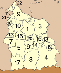
Amphoe
An amphoe is the second level administrative subdivision of Thailand. Usually translated as district, amphoe make up the provinces, and are analogous to a county seat...
). The districts are further subdivided into 206 subdistricts (tambon
Tambon
Tambon is a local government unit in Thailand. Below district and province , they form the third administrative subdivision level. As of the 2009 there are 7255 tambon, not including the 169 khwaeng of Bangkok, which are set at the same administrative level, thus every district contains 8-10 tambon...
) and 2411 villages (muban
Muban
Muban is the lowest administrative subdivision of Thailand. Usually translated as village, they are the subdivision of tambon. As of 2008, there are 74944 administrative villages in Thailand. As of the 1990 census, the average village consisted of 144 households or 746 persons.A muban does not...
).
|
|
Khmer ruins
Sisaket province is famous for its ruins dating to the Ancient Khmer EraKhmer Empire
The Khmer Empire was one of the most powerful empires in Southeast Asia. The empire, which grew out of the former kingdom of Chenla, at times ruled over and/or vassalized parts of modern-day Laos, Thailand, Vietnam, Burma, and Malaysia. Its greatest legacy is Angkor, the site of the capital city...
. These include:
Tamnaksai Khmer Ruins (Tamchan Khmer Ruins) ปราสาทตำหนักไทร (ปราสาททามจาน) This is a single stupa
Stupa
A stupa is a mound-like structure containing Buddhist relics, typically the remains of Buddha, used by Buddhists as a place of worship....
of brick on a sandstone
Sandstone
Sandstone is a sedimentary rock composed mainly of sand-sized minerals or rock grains.Most sandstone is composed of quartz and/or feldspar because these are the most common minerals in the Earth's crust. Like sand, sandstone may be any colour, but the most common colours are tan, brown, yellow,...
base. The stupa is rectangular. There is door on the east, while the other three sides have entrances with a door frame carved into the brickwork.
Bas relief - Carved on the red sandstone cliff, this depicts three gods in Khmer style. Khmer craftsmen probably practised here first before doing the actual carving for Preah Vihear Sanctuary.
Sra Trao or Huay Trao - This stream runs through rock at the foot of Preah Vihear Mountain, before entering a subterranean tunnel strengthened by rock walls. It is assumed that the lowland was once used as a Barai
Barai
Barai is a village development committee in Udayapur District in the Sagarmatha Zone of south-eastern Nepal. At the time of the 1991 Nepal census it had a population of 4613.-External links:*...
(Khmer reservoir
Reservoir
A reservoir , artificial lake or dam is used to store water.Reservoirs may be created in river valleys by the construction of a dam or may be built by excavation in the ground or by conventional construction techniques such as brickwork or cast concrete.The term reservoir may also be used to...
).
Phra That Ruang Rong (พระธาตุเรืองรอง) - The temple's architecture is a blending of art from four ethnic groups in Lower Northeast: Lao
Lao people
The Lao are an ethnic subgroup of Tai/Dai in Southeast Asia.-Names:The etymology of the word Lao is uncertain, although it may be related to tribes known as the Ai Lao who appear in Han Dynasty records in China and Vietnam as a people of what is now Yunan Province...
, Suay, Khmer, and Yer
Yer
The letter yer of the Cyrillic alphabet, also spelled jer or er, is known as the hard sign in the modern Russian and Rusyn alphabets and as er golyam in the Bulgarian alphabet...
. The Phra That Or stupa is 49 metres high.
Sra Kampaeng Noi Khmer Ruins (ปราสาทสระกำแพงน้อย) - These Khmer ruins include a laterite
Laterite
Laterites are soil types rich in iron and aluminium, formed in hot and wet tropical areas. Nearly all laterites are rusty-red because of iron oxides. They develop by intensive and long-lasting weathering of the underlying parent rock...
stupa and chapel with a big pond at front, all within a laterite wall. In the 13th century, additions were made in the Bayon
Bayon
The Bayon is a well-known and richly decorated Khmer temple at Angkor in Cambodia. Built in the late 12th century or early 13th century as the official state temple of the Mahayana Buddhist King Jayavarman VII, the Bayon stands at the centre of Jayavarman's capital, Angkor Thom...
architectural style. It once contained a community hospital known as the ‘Arokaya Sala’.
Sra Kampaeng Yai Khmer Ruins (ปราสาทสระกำแพงใหญ่) - This is the largest and most complete Khmer complex in the province. The site includes three stupas on the same base lined in a north-south direction and facing east. It was a originally shrine dedicated to Shiva
Shiva
Shiva is a major Hindu deity, and is the destroyer god or transformer among the Trimurti, the Hindu Trinity of the primary aspects of the divine. God Shiva is a yogi who has notice of everything that happens in the world and is the main aspect of life. Yet one with great power lives a life of a...
, but was converted to a Mahayana
Mahayana
Mahāyāna is one of the two main existing branches of Buddhism and a term for classification of Buddhist philosophies and practice...
Buddhist temple in 13th Century.
Huay Tap Tan Khmer Ruins or Ban Prasart Khmer Ruins (ปราสาทห้วยทับทัน หรือ ปราสาทบ้านปราสาท) - This consists of 3 brick stupas on laterite base aligned in North-South direction. They stand inside laterite walls with arch gates. The carved lintels depicting the churning of the sea of milk
Samudra manthan
In Hinduism, Samudra manthan or Ksheera Sagara Mathanam, Churning of the Ocean of Milk is one of the most famous episodes in the Puranas...
lies in front of the southern stupa.
Plang Ku Khmer Ruins (ปราสาทปรางค์กู่) - The Stupa of this Khmer ruin complex was built in gigantic-size. In front of Plang Ku is a big pond which is home to Anatidae
Anatidae
Anatidae is the biological family of birds that includes ducks, geese and swans. The family has a cosmopolitan distribution, occurring on all the world's continents except Antarctica and on most of the world's islands and island groups...
species which gather from February onwards.
Ban Samor Khmer Ruins (ปราสาทบ้านสมอ) - This small Khmer ruin is located in Moo 2 Ban Tamchan, Tambon Samor. Built in the 13th Century, its stupa houses a carved statue.
Taleng Khmer Ruins (ปราสาทตาเล็ง) - This features a single stupa standing on a rectangular base. The stupa's base faces east. Only the front wall and some side walls remain.
Preah Vihear Sanctuary (ปราสาทเขาพระวิหาร) - The famous cliff-top Khmer sanctuary is near a disputed area between Thailand and Cambodia which has drawn much attention. It was listed as an antique architectural site by the Royal Thai Fine Arts Department, with an announcement in the Royal Gazette on October 11, 1940. Following an international Court ruling on July 15, 1962, however, the Hindu sanctuary is now on the Cambodian side of the border. Access must still be made through Thailand. An area of 4.6 square kilometers adjoining the temple is claimed by both countries is has been the scene of sporadic clashes between Thai and Cambodian border patrols.
Wat Maha Buddharam (วัดมหาพุทธาราม) - This Buddhist temple’s vihara houses ‘Luang Por To’ the sacred icon of Sisaket. Dating back to the Khmer era over a thousand years ago, the statue was carved from stone and later later at unknown time.
Phra Viharn National Park

Khao Phra Wihan National Park
Khao Phra Wihan National Park is a protected natural area in Sisaket Province, Thailand, that contains numerous ruins of the 11th century Khmer Empire. The park lies south of the town of Sisaket, at the end of Thai highway 221...
(อุทยานแห่งชาติเขาพระวิหาร) - The park features dry evergreen forest, mixed dipterocarp forest, and deciduous dipterocarp forest with tree species like Pterocarpus macrocarpus
Pterocarpus macrocarpus
Pterocarpus macrocarpus is a species of Pterocarpus native to southeastern Asia in northeastern India, Burma, Laos, Thailand, and Vietnam....
, Shorea siamensis
Shorea siamensis
Shorea siamensis is a species of plant in the Dipterocarpaceae family. It is a tree found in Indonesia, Malaysia, Myanmar, Vietnam and Thailand.-References:...
and Xylia xylocarpa var. kerrii
Xylia xylocarpa
Xylia xylocarpa is a species of tree in the Mimosoideae subfamily of the Fabaceae family. This tree is found in South and Southeast Asia.-Description and properties:...
. It is home to numerous wildlife which roams between two countries such as wild hog, deer, barking deer, rabbit, squirrel, gibbon
Gibbon
Gibbons are apes in the family Hylobatidae . The family is divided into four genera based on their diploid chromosome number: Hylobates , Hoolock , Nomascus , and Symphalangus . The extinct Bunopithecus sericus is a gibbon or gibbon-like ape which, until recently, was thought to be closely related...
and civet. Phra Viharn National Park features interesting sights including:
Double Stupas - Two sandstone stupas, or ‘Phra That’ for the local people, in cube shape and round top are situated west or Mo E-Dang Cliff. The stupas house items that mirror the prosperity of the Khmer period.
Don Tuan Khmer Ruins - Built during the 10th -11th Century, the Khmer Ruins in Ban Phume Sarol is located 300 metres from Thailand-Cambodia border. Legend tells that in the past a lady known as Nang Nom Yai or Nieng Non dor (in Khmer
Khmer language
Khmer , or Cambodian, is the language of the Khmer people and the official language of Cambodia. It is the second most widely spoken Austroasiatic language , with speakers in the tens of millions. Khmer has been considerably influenced by Sanskrit and Pali, especially in the royal and religious...
), stopped to rest here on her way to visit a king.
Mo E-Dang Cliff - One of the best bird’s eye view point of Northeast, the red-colour rock cliff is situated right on Thailand-Cambodia border.
Namtok and Tham Khun Sri - The three-tiered waterfall, above the cave, is situated west of Sra trao close to trail to Phreah Vihear. Khun Sri Cave is of gigantic proportions and was believed to have been the accommodation of Khun Sri, a noble man who controlled rock cutting at Sra Trao at the time of the construction of Preah Vihear Sanctuary.
Namtok Phu La-Ō (น้ำตกภูละออ) - Situated in Phanom Dongrak Wildlife Sanctuary, Tambon Sao Thongchai, the small waterfall turns vibrant during September to February.
Other sights
Somdet Sri Nagarin Park (สวนสมเด็จศรีนครินทร์) - With landscape of rolling hills, the park is nourished by two streams, Huay Poon Yai and Huay Poon Noi that meet north of the park. Here is rich of ‘Lamduan’ or Lamdman Tree, making it a nice place for botanical excursion.Fruit Orchard of Sisaket (เส้นทางเที่ยวชมสวนชิมผลไม้ศรีสะเกษ) - Some 5 km from Amphoe Kantaralak, on the right of highway 226 (Kantaralak-Pha Mor E-Dang) there is a 20-km (16 km on asphalt road) cutting through villages. These villages are significant fruit producers of Sisaket. Their major products include rambutan, durian, longan
Longan
Dimocarpus longan, commonly known as the longan, is a tropical tree native to South and Southeast Asia, in the Indomalaya ecozone known for its edible fruit.-Vernacular names:The fruit is known as longan or longyan in English...
, mangosteen, stink bean and rubber
Rubber
Natural rubber, also called India rubber or caoutchouc, is an elastomer that was originally derived from latex, a milky colloid produced by some plants. The plants would be ‘tapped’, that is, an incision made into the bark of the tree and the sticky, milk colored latex sap collected and refined...
.
Khun Ampai Panich Building (ตึกขุนอำไพพาณิชย์) - The beautiful building belongs to Sisaket nobleman Khun Ampai Panich (In Naga-siharat). It is well renovated and preserved, and eventually won gold medal in the project of conversing urban architecture in 1987.
Wat Pa Maha Chedi Kaew
Wat Pa Maha Chedi Kaew
Wat Pa Maha Chedi Kaew , also known colloquially as The Million Bottle Temple, is an unconventional contemporary Buddhist temple in Khun Han district of Sisaket province, Thailand. The temple is made of over 1 million empty discarded beer bottles. The construction was initiated in 1984.-External...
(Wat Larn Kuad) (วัดป่ามหาเจดีย์แก้ว [วัดล้านขวด]) - The Buddhist temple is remarkable with architectures made from million of colourful glass bottles donated by the people. Its architecture is interesting, particularly the pavilion called ‘Sala Thansmo Maha Jedikaeo’ Ubosoth located mid of the pond.
Namtok Samrong Kiat (Namtok Pisad) (น้ำตกสำโรงเกียรติ [น้ำตกปีศาจ]) - Originating in Kantung Mount in the Bantad Range, this medium-sized waterfall turns vibrant from late rainy season to winter, from September to February.
Namtok Huay Chan (Namtok Kantrom) (น้ำตกห้วยจันทร์ [น้ำตกกันทรอม]) - Originated from Phu Salao Mount on Bantad Range, the waterfall cascades beautifully before meeting with Mun River
Mun River
The Mun River , sometimes spelled Moon River, is a tributary of the Mekong river. It carries approximately 21,000 cubic kilometres of water per year.-Geography:...
. The falls is vibrant from September to Frebruary.
Sisa Asoka (ศีรษะอโศก) - is a community model in self sufficiency, showcasing people who prefer Buddhism-devout lifestyle. Its remarkable success attracts organizations from nationwide to study its story.
Namtok and Tham Khun Sri - The three-tier waterfall, above the cave, is situated west of Sra trao close to trail to Phreah Vihear. And Khun Sri Cave in gigantic size was believed once was accommodation of Khun Sri, noble man who controlled rock cutting at Sra Trao for constructing Preah Vihear Sanctuary.
Chong Arn Ma - The border check point between Thailand and Cambodia is in Tambon Song, Amphoe Nam Yuen, Ubon Ratchathani.
Local Products
Sisaket is famed for silk and cotton cloths woven in ‘KhitKhit
Khit, or Khid, is an ancient type of woven cloth produced in certain areas of Isaan, the northeastern region of Thailand.-Tradition:Khit weaving is done by hand in traditional looms. It favours certain basic colors, like red, purple and dark green, although other colors are also used...
’ pattern, which are mainly produced in Amphoe Bung Boon and Uthumporn Pisai. Delicate basketry and wooden works such as water holder, replica cart are available on Rachakarn Rodfai Rd.
Saltened egg from Amphoe Prai Bung, red onion, garlic, and preserved garlic in honey are generally available. Sisaket is also famed for its tropical fruits. Fruit orchards in Amphoe Kantaralak bear fruit, such as durian
Durian
The durian is the fruit of several tree species belonging to the genus Durio and the Malvaceae family . Widely known and revered in southeast Asia as the "king of fruits", the durian is distinctive for its large size, unique odour, and formidable thorn-covered husk...
, rambutan
Rambutan
The rambutan is a medium-sized tropical tree in the family Sapindaceae, and the fruit of this tree. It is native to Vietnam, Indonesia, the Philippines, Sri Lanka, Malaysia, and elsewhere in Southeast Asia, although its precise natural distribution is unknown. It is closely related to several...
, and mangosteen
Mangosteen
The purple mangosteen , colloquially known simply as mangosteen, is a tropical evergreen tree believed to have originated in the Sunda Islands and the Moluccas of Indonesia. The tree grows from 7 to 25 m tall...
, from May to July. The quality of the fruit here is as good as in the rest of Thailand.
Festivals
Dok Lamduan Festivals (งานเทศกาลดอกลำดวน) - Held annually between March 15–17 at Somdet Sri Nagarin Park when lamdman trees in the park are in full bloom, The fair comprises cultural performance of four local ethnic groups namely Khmer, Suay, Lao, and Yer. Fair goer can enjoy selecting handicrafts, local products, and watching performance of Sisaket’s history.Sisaket’s Rambutan and Durian Fair (งานเทศกาลเงาะทุเรียนศรีสะเกษ) - The fair is held every June at the field before Amphoe Kantaralak or Amphoe Khun Harn. Fair goer can enjoy the big sales of fruits from Sisaket such as rambutan, durian, lanson, mangosteen, stink beam and rubber, flower floats, documentary exhibition, and fruit tasting caravan.
Half and Quarter Marathon to Mor E-Dang (การแข่งขันวิ่งฮาล์ฟและควอเตอร์มาราธอนสู่ผามออีแดง) - Held annually on the third Sunday of December, the half and quarter marathon will start from Ban Phume Sarol to Mor E-Dang Cliff, on the way to Preah Vihear. This uphill and foggy route to the border is a quite challenging route which attracts lots of runners.
See also
- Khit cloth
- Si in place names
- Sisaket F.C.
- Sri Nakhon Lamduan StadiumSri Nakhon Lamduan StadiumSri Nakhon Lamduan Stadium |city of Sisaket]] in Thailand. It is the home stadium of Sisaket F.C. of the Thai Premier League. The stadium holds 10,000 spectators.-External links:*...
External links
- Website of Province (Limited English section)
- Si Saket provincial map, coat of arms and postal stamp