
Silba
Encyclopedia

Croatia
Croatia , officially the Republic of Croatia , is a unitary democratic parliamentary republic in Europe at the crossroads of the Mitteleuropa, the Balkans, and the Mediterranean. Its capital and largest city is Zagreb. The country is divided into 20 counties and the city of Zagreb. Croatia covers ...
, northern Dalmatia
Dalmatia
Dalmatia is a historical region on the eastern coast of the Adriatic Sea. It stretches from the island of Rab in the northwest to the Bay of Kotor in the southeast. The hinterland, the Dalmatian Zagora, ranges from fifty kilometers in width in the north to just a few kilometers in the south....
, south-east of Lošinj
Lošinj
Lošinj is a Croatian island in the northern Adriatic Sea, in the Kvarner Gulf. It is almost due south of the city of Rijeka and part of the Primorje-Gorski Kotar county....
, between the islands of Premuda
Premuda
Premuda is a little island in Croatia, off the northern Adriatic coast. It belongs to the north Dalmatian islands which are situated north-west from the county center Zadar. Premuda is approximately 10 km long, up to 1 km wide, and has an area of 9.2 square kilometers...
and Olib
Olib
Olib is an island in northern Dalmatia, located northwest of Zadar, southwest of Pag, southeast of Lošinj and just east of Silba. The population is 147.-History:...
. It has a Mediterranean climate
Mediterranean climate
A Mediterranean climate is the climate typical of most of the lands in the Mediterranean Basin, and is a particular variety of subtropical climate...
with 2570 hours a year of sunshine. Most summer days are hot, bright and clear with light westerly Maestral wind cooling the island in the afternoons.
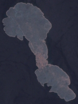
Silba has an area 15 km² in the shape of number 8, with the village of Silba located at the narrowest point in the middle. It takes only around 10 minutes to walk the 600 m from the north-eastern harbour of Mul to the south-western harbour of Žalić (Zhaleech).
Officially, Silba's population is 265 (2001), but it varies seasonally; from a few hundred, mainly pensioners, in the winter, to several thousand during summer months. Many have jobs and properties on the mainland. There is also an influx of tourists during the summer months as tourism is now the main economic activity on the island. The whole island is a pedestrian zone, no traffic is allowed with the exception of vehicles supplying the local businesses.
Zadar
Zadar
Zadar is a city in Croatia on the Adriatic Sea. It is the centre of Zadar county and the wider northern Dalmatian region. Population of the city is 75,082 citizens...
is Silba's mainland administrative center; it is part of the Zadar County
Zadar County
Zadar County is a county in Croatia, it encompasses northern Dalmatia and southeastern Lika. Its center is the city of Zadar.- Population :According to the 2001 census, Zadar County has population of 162,045...
.
Geography
The island has numerous small beaches and coves. The main public beach Sotorišće (Sotoreeshche), located close to the harbour of Mul, has very clear shallow waters with sandy bottom. On Žalić, there are a number of pebbly beaches and a pier. Ships carrying passenger and commercial traffic dock here.There are a number of coves outside the village that can be reached by footpaths. On the southern side of the island, at walking distances of about 30–45 minutes, are:
- Vele Stene (Large Rocks), the only point on the island where the shores are steep and rocky.
- Port Sv. Ante, favoured with yachtsmen because it is protected from major winds.
One can also view a small chapel on the side of the bay.
- Dobre Vode, a beach with shallow sandy bottom.
- Nozdre, a big cove with characteristic flat rock formations cut out by the sea.
On the north side of the village is the highest point on Silba, Varh (80m). The northern shore is less accessible than the southern due to rocky shores, however, there is a path leading north out of the village to the small port of Papranica. Further on along the path, about an hours walk from the main village, is a cove Pernastica which is considered one of the nicest coves on the island. It faces westwards towards the sunset and has a long shallow sandy bottom.
Silba's most popular landmark is Toreta, a sleek tower with a spiral staircase from which there is a wonderful view of the surrounding islands. It is in the centre of the village right on Veli Put - Silba's High Street. The village has several cafés, four restaurants, a number of shops, post office and a local GP. From any point in the village it takes only around 10 min or less to walk to the nearest beach.
History
The old name for this island is Selbo. The island Silba is mentioned in historical records in the 9th century. In 827, it belonged to the ZadarZadar
Zadar is a city in Croatia on the Adriatic Sea. It is the centre of Zadar county and the wider northern Dalmatian region. Population of the city is 75,082 citizens...
county. In 1073, in the last year of Petar Krešimir's reign, probably at the request of his sister Cika, the first nun of St. Maria in Zadar, the county donated the island to the monastery St. Maria, at the ceremony of sacrament of their church (some say this happened in 1027.). Later, the island fell into the hands of the Venetian
Republic of Venice
The Republic of Venice or Venetian Republic was a state originating from the city of Venice in Northeastern Italy. It existed for over a millennium, from the late 7th century until 1797. It was formally known as the Most Serene Republic of Venice and is often referred to as La Serenissima, in...
authorities, which sold it to captain Fani Soppe for 12,350 ducats.
It is not known how it later came into the ownership of Venetian family Morosini. Silba was held by family Morosini until the first quarter of 19th century. As it was too far to govern and receive tax on yield in nature they agreed with inhabitants of Silba in 1770 to receive each year 2000 Venetian lira
Venetian lira
The lira was the distinct currency of the Venice until 1807. It was subdivided into 20 soldi, each of 12 denari. The ducato was equal to 124 soldi, whilst the tallero was equal to 7 lire...
in rent. Silbans called this rent četvrtina (quarter), as it amounted to quarter of the land's yields, which is what serfs elsewhere also gave to their masters.
In 1838, for 28,500 Austrian lira, family Morosini sold the island to Marko Ragusin from Veli Lošinj
Lošinj
Lošinj is a Croatian island in the northern Adriatic Sea, in the Kvarner Gulf. It is almost due south of the city of Rijeka and part of the Primorje-Gorski Kotar county....
, who returned wealthy from USA.
As Silbans paid rent to previous owner in currency, they assumed they will do the same to the new landowner, but since he lived in Lošinj, near to Silba, he refused and demanded a quarter of land's yield in crop. A lawsuit ensued which lasted for 13 years when Ragusin finally decided to sell the island to these same inhabitants who bought it, each paying proportionally to the size of their plot, in total 5,025 bavarian thalers
Thaler
The Thaler was a silver coin used throughout Europe for almost four hundred years. Its name lives on in various currencies as the dollar or tolar. Etymologically, "Thaler" is an abbreviation of "Joachimsthaler", a coin type from the city of Joachimsthal in Bohemia, where some of the first such...
. On 19 March 1852 ownership of the island by inhabitants was registered. It became the island's main holiday, day of St. Joseph.
In the 18th century Silba had a fleet 38 sailing boats with three masts called Manzere of 220 Mt
Tonne
The tonne, known as the metric ton in the US , often put pleonastically as "metric tonne" to avoid confusion with ton, is a metric system unit of mass equal to 1000 kilograms. The tonne is not an International System of Units unit, but is accepted for use with the SI...
and 60 sailing boats two masts called Kastrere of 63 Mt
Tonne
The tonne, known as the metric ton in the US , often put pleonastically as "metric tonne" to avoid confusion with ton, is a metric system unit of mass equal to 1000 kilograms. The tonne is not an International System of Units unit, but is accepted for use with the SI...
. The fleet was destroyed by the French
Illyrian provinces
The Illyrian Provinces was an autonomous province of the Napoleonic French Empire on the north and east coasts of the Adriatic Sea between 1809 and 1816. Its capital was established at Laybach...
at the beginning of the 19th century. The economic benefits to the island from sailing boats led to general well being on the island. Old local saying says: "Silba zlatom siva, i u njoj se raj uživa", that is: "Silba shines with gold, on it heavenly enjoyment".
In the olden days there was a custom of "village king" elections. The king would get elected on St. Stephen's Day
St. Stephen's Day
St. Stephen's Day, or the Feast of St. Stephen, is a Christian saint's day celebrated on 26 December in the Western Church and 27 December in the Eastern Church. Many Eastern Orthodox churches adhere to the Julian calendar and mark St. Stephen's Day on 27 December according to that calendar, which...
(26 December) and his rule would last until Three Kings (6 January). During his twelve day rule, he would preside, with crown on his head, surrounded by twelve councillors, over village gatherings and dealt justice. His task was to name the village head, head and members of village guards; close the previous years budget and plan the next years. He would give verdict on complaints and disputes that have accumulated during the year. This custom died out in the first quarter of the 19th century. The king's crown still exists in the treasury of the parish church.
In 1943 Silba was the scene of a naval action during the Adriatic Campaign of World War II
Adriatic Campaign of World War II
The Adriatic Campaign of World War II was a minor naval campaign fought during World War II between the Greek, Yugoslavian and Italian navies, the Kriegsmarine, and the Mediterranean squadrons of the United Kingdom, France, and the Yugoslav Partisan naval forces...
.
Sources
- Jurić, Ljubimir. Silba (1910) (reprint 1991: Društvo za zaštitu prirode Silba)