
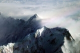
Shispare
Encyclopedia
Shispare is one of the high peaks of the Batura Muztagh
,
which is the westernmost subrange of the Karakoram
range
.
Alternate forms of the name of this peak are Shispare Sar and Shisparé Sar.
Wall, which is the highest part of the Batura Muztagh
.
The Hunza River
curves around the southwest, west, and northwest sides of the Batura Muztagh, and Shispare towers above the western bank of the river.
In turn, the Hunza Valley
lies in the Gilgit District
of Gilgit-Baltistan, Pakistan.
has an elevation of 2060 m (6,759 ft), making for 5550 m (18,208.7 ft) of relief, in only 13 km (8 mi) horizontal distance. Being near the end of the Batura
Muztagh, it commands large drops in three directions (north, east, and south).
In addition, Shispare has a strikingly large and steep Northeast Face.
. Shispare was the first major peak in the range to be successfully climbed, in 1974, by the "Polish-German Academic Expedition" under the leadership of Janusz Kurczab. The ascent took 35 days, and during preparations for a second group to try for the summit, one member of the expedition (Heinz Borchers) was killed in an avalanche
.
The first ascent route followed the Pasu Glacier
to the East Ridge, between the Pasu and Ghulkin glaciers.
(Note: this ridge goes southeast from the summit, turns northeast, and then turns roughly east, so it is called the
"southeast ridge" and the "northeast ridge" in different sources.)
Difficulties included a long ice ridge, and the access to the ridge required 1500m of fixed rope
.
The next attempt was in 1989 by members of the Ryukoku University Alpine Club in Japan, led by Masato Okamoto. The group was on the mountain for almost two months, but was not able to summit; their high point was around 7200 m (23,622 ft).
In 1994, a group from the Komono Alpine Club in Japan
, led by Yukiteru Masui, achieved the second ascent of the peak. They reached Base Camp on June 18, and Masui, Kokubu, and Ozawa reached the summit on July 20. They followed the same route as the first ascent party and climbed in a similar style, with a similar amount of fixed rope.
The Himalayan Index lists no other ascents or attempts of this peak.
Batura Muztagh
The Batura Muztagh mountains are a sub-range of the Karakoram mountain range. They are located west of the Hunza Valley in the Gilgit District of the Gilgit-Baltistan province in northern Pakistan....
,
which is the westernmost subrange of the Karakoram
Karakoram
The Karakoram, or Karakorum , is a large mountain range spanning the borders between Pakistan, India and China, located in the regions of Gilgit-Baltistan , Ladakh , and Xinjiang region,...
range
Mountain range
A mountain range is a single, large mass consisting of a succession of mountains or narrowly spaced mountain ridges, with or without peaks, closely related in position, direction, formation, and age; a component part of a mountain system or of a mountain chain...
.
Alternate forms of the name of this peak are Shispare Sar and Shisparé Sar.
Location
Shispare lies east of the BaturaBatura Sar
Batura Sar, also referred to as Batura I, is the 25th highest mountain on earth and the 10th highest in Pakistan. It is the highest peak of the Batura Muztagh, which is the westernmost subrange of the Karakoram range...
Wall, which is the highest part of the Batura Muztagh
Batura Muztagh
The Batura Muztagh mountains are a sub-range of the Karakoram mountain range. They are located west of the Hunza Valley in the Gilgit District of the Gilgit-Baltistan province in northern Pakistan....
.
The Hunza River
Hunza River
Hunza River is the principal river of Hunza, in the Northern Areas of Pakistan. It is formed by the confluence of the Kilik and Khunjerab nalas which are fed by glaciers. It is joined by the Gilgit River and the Naltar River before it flows into the Indus River.The river cuts through the...
curves around the southwest, west, and northwest sides of the Batura Muztagh, and Shispare towers above the western bank of the river.
In turn, the Hunza Valley
Hunza Valley
The Hunza Valley is a mountainous valley in the Gilgit-Baltistan region of Pakistan. The Hunza valley is situated to the north of the Hunza River, at an elevation of around . The territory of Hunza is about...
lies in the Gilgit District
Gilgit District
Gilgit District is one of the districts of the federal territory of Gilgit-Baltistan in northern Pakistan. It was formed in 1970 when Gilgit-Baltistan was federally administered as the "Northern Areas". It is bounded by the Wakhan Corridor to the north; Xinjiang to the northeast and east; Skardu,...
of Gilgit-Baltistan, Pakistan.
Notable Features
Shispare is notable for its tremendous rise above local terrain. For example, the nearby town of Karimabad, in the Hunza Valley,has an elevation of 2060 m (6,759 ft), making for 5550 m (18,208.7 ft) of relief, in only 13 km (8 mi) horizontal distance. Being near the end of the Batura
Muztagh, it commands large drops in three directions (north, east, and south).
In addition, Shispare has a strikingly large and steep Northeast Face.
History
Climbing began in the Batura Muztagh later than in other parts of the KarakoramKarakoram
The Karakoram, or Karakorum , is a large mountain range spanning the borders between Pakistan, India and China, located in the regions of Gilgit-Baltistan , Ladakh , and Xinjiang region,...
. Shispare was the first major peak in the range to be successfully climbed, in 1974, by the "Polish-German Academic Expedition" under the leadership of Janusz Kurczab. The ascent took 35 days, and during preparations for a second group to try for the summit, one member of the expedition (Heinz Borchers) was killed in an avalanche
Avalanche
An avalanche is a sudden rapid flow of snow down a slope, occurring when either natural triggers or human activity causes a critical escalating transition from the slow equilibrium evolution of the snow pack. Typically occurring in mountainous terrain, an avalanche can mix air and water with the...
.
The first ascent route followed the Pasu Glacier
Glacier
A glacier is a large persistent body of ice that forms where the accumulation of snow exceeds its ablation over many years, often centuries. At least 0.1 km² in area and 50 m thick, but often much larger, a glacier slowly deforms and flows due to stresses induced by its weight...
to the East Ridge, between the Pasu and Ghulkin glaciers.
(Note: this ridge goes southeast from the summit, turns northeast, and then turns roughly east, so it is called the
"southeast ridge" and the "northeast ridge" in different sources.)
Difficulties included a long ice ridge, and the access to the ridge required 1500m of fixed rope
Fixed rope
Fixed rope is the practice of fixing in place bolted ropes to assist climbers and walkers in exposed mountain locations. They are used widely on American and European climbing routes but disdained by purist mountaineers. Many guided expeditions to any of the eight-thousanders normally set up fixed...
.
The next attempt was in 1989 by members of the Ryukoku University Alpine Club in Japan, led by Masato Okamoto. The group was on the mountain for almost two months, but was not able to summit; their high point was around 7200 m (23,622 ft).
In 1994, a group from the Komono Alpine Club in Japan
Japan
Japan is an island nation in East Asia. Located in the Pacific Ocean, it lies to the east of the Sea of Japan, China, North Korea, South Korea and Russia, stretching from the Sea of Okhotsk in the north to the East China Sea and Taiwan in the south...
, led by Yukiteru Masui, achieved the second ascent of the peak. They reached Base Camp on June 18, and Masui, Kokubu, and Ozawa reached the summit on July 20. They followed the same route as the first ascent party and climbed in a similar style, with a similar amount of fixed rope.
The Himalayan Index lists no other ascents or attempts of this peak.
Climbing
The first (and second) ascent route is described above. It is likely that any other ascent route would involve (at least) similar difficulties, making this a highly challenging peak.Books/pamphlets/maps about Shispare
- High Asia: An Illustrated History of the 7000 Metre Peaks by Jill Neate, ISBN 0-89886-238-8
- Batura Mustagh (sketch map and pamphlet) by Jerzy Wala, 1988.
- Orographical Sketch Map of the Karakoram by Jerzy Wala, 1990. Published by the Swiss Foundation for Alpine Research.
Other references
- American Alpine JournalAmerican Alpine JournalThe American Alpine Journal is an annual magazine published by the American Alpine Club. Its mission is "to document and communicate mountain exploration."...
, 1975, pp. 215–216 - American Alpine JournalAmerican Alpine JournalThe American Alpine Journal is an annual magazine published by the American Alpine Club. Its mission is "to document and communicate mountain exploration."...
, 1990, pp. 294–295 - American Alpine JournalAmerican Alpine JournalThe American Alpine Journal is an annual magazine published by the American Alpine Club. Its mission is "to document and communicate mountain exploration."...
, 1995, pp. 295–296
External links
- Himalayan Index
- Microsoft Encarta Map of Shispare
- A clickable map of the Batura Muztagh
- A short entry in French about the first ascent.
- DEM files for the Himalaya (Corrected versions of SRTM data; Shispare is in the "Batura Sar" tile)
- Aerial Photos of Shispare by Brian McMorrow