
Shire of Beaudesert
Encyclopedia
South East Queensland
South East Queensland is a region of the state of Queensland in Australia, which contains approximately two-thirds of the state population...
Queensland
Queensland
Queensland is a state of Australia, occupying the north-eastern section of the mainland continent. It is bordered by the Northern Territory, South Australia and New South Wales to the west, south-west and south respectively. To the east, Queensland is bordered by the Coral Sea and Pacific Ocean...
, Australia
Australia
Australia , officially the Commonwealth of Australia, is a country in the Southern Hemisphere comprising the mainland of the Australian continent, the island of Tasmania, and numerous smaller islands in the Indian and Pacific Oceans. It is the world's sixth-largest country by total area...
, stretching from the New South Wales
New South Wales
New South Wales is a state of :Australia, located in the east of the country. It is bordered by Queensland, Victoria and South Australia to the north, south and west respectively. To the east, the state is bordered by the Tasman Sea, which forms part of the Pacific Ocean. New South Wales...
border, along the Gold Coast
Gold Coast, Queensland
Gold Coast is a coastal city of Australia located in South East Queensland, 94km south of the state capital Brisbane. With a population approximately 540,000 in 2010, it is the second most populous city in the state, the sixth most populous city in the country, and also the most populous...
hinterland
Hinterland
The hinterland is the land or district behind a coast or the shoreline of a river. Specifically, by the doctrine of the hinterland, the word is applied to the inland region lying behind a port, claimed by the state that owns the coast. The area from which products are delivered to a port for...
to the urban fringes of the cities of Brisbane
Brisbane
Brisbane is the capital and most populous city in the Australian state of Queensland and the third most populous city in Australia. Brisbane's metropolitan area has a population of over 2 million, and the South East Queensland urban conurbation, centred around Brisbane, encompasses a population of...
and Ipswich
Ipswich, Queensland
Ipswich is a city in South-East Queensland, Australia. Situated along the Bremer River Valley approximately 40 kilometres away from the state's capital Brisbane. The suburb by the same name forms the city's Central Business District and administrative centre...
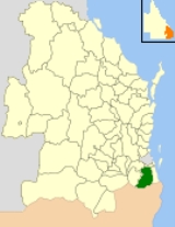
. The shire covered an area of 2854.3 square kilometres (1,102.1 sq mi), and existed from 1879 until its abolishment on 15 March 2008, following which it was split between Logan City and the new Scenic Rim Region.
History
The Tabragalba Divisional Board was incorporated on 11 November 1879 under the Divisional Boards Act 1879, centred on BeaudesertBeaudesert, Queensland
Beaudesert is a town located on the Mount Lindesay Highway, some 64 km south of Brisbane. It is possibly named after Beau Desert Park, the property of Charles Henry Alexander Paget, 6th Marquess of Anglesey in Staffordshire, England...
. With the passage of the Local Authorities Act 1902, Tabragalba became a shire council on 31 March 1903, and on 8 August 1903 was renamed Beaudesert by an Order in Council. Between 23 November 1912 and 14 September 1929, a separate Beaudesert Town Council managed the town itself.
On 9 December 1948, an Order in Council abolished the Shires of Nerang, Tamborine and Waterford and included the latter two and part of Nerang into a new Shire of Beaudesert. Waterford had existed largely unaltered since being created as a Divisional Board in 1879, while Tamborine (spelt Tambourine until 14 January 1939) had split away from Tabragalba on 4 October 1890. The Shire of Beaudesert was split into four divisions with a total of eight councillors—Division 2 with four, Division 4 with two and the others with one each. The chairman (later mayor) was to be chosen from amongst the councillors. The new council was formally established at elections on 31 May 1949 and a Special Meeting was held on 7 June. It had grown 40% in population and gained 1045 km² (403 sq mi) in the process.
On 8 June 1978, the Shire of Logan was created out of parts of Beaudesert and the Shire of Albert
Shire of Albert
The Shire of Albert was a Local Government Area in Queensland, located south of the capital, Brisbane, and taking in areas to the north and west of the Gold Coast. It was named after the Prince Consort of the United Kingdom, and husband of Queen Victoria, Prince Albert...
. The council lost 146.1 km² (56.4 sq mi) of its area and 11,550 people to Logan. At the 1979 council elections, Beaudesert was resubdivided into eight divisions each electing one councillor.
On 15 March 2008, under the Local Government (Reform Implementation) Act 2007 passed by the Parliament of Queensland
Parliament of Queensland
The Parliament of Queensland is the legislature of Queensland, Australia. According to the state's constitution, the Parliament consists of the Queen and the Legislative Assembly. It is the only unicameral state parliament in the country, the upper chamber, the Legislative Council, having been...
on 10 August 2007, Beaudesert was abolished and became one of only three Queensland councils, alongside Taroom
Shire of Taroom
The Shire of Taroom was a Local Government Area located in the Darling Downs region of Queensland, Australia, along the Leichhardt Highway to the north of Miles...
and Tiaro
Shire of Tiaro
The Shire of Tiaro was a Local Government Area located in the Wide Bay-Burnett region of Queensland, Australia, between the regional cities of Gympie and Hervey Bay about north of the state capital, Brisbane...
, to be split in two. The northern area, which while still largely rural was part of Brisbane
Brisbane
Brisbane is the capital and most populous city in the Australian state of Queensland and the third most populous city in Australia. Brisbane's metropolitan area has a population of over 2 million, and the South East Queensland urban conurbation, centred around Brisbane, encompasses a population of...
's growth corridor, became part of Logan City, while the southern rural section became part of the Scenic Rim Region alongside the Shire of Boonah
Shire of Boonah
The Shire of Boonah was a Local Government Area located in South East Queensland, Australia, about southwest of Brisbane. The shire covered an area of , and existed from 1880 until its merger with parts of the Shire of Beaudesert and City of Ipswich to form the Scenic Rim Region on 15 March...
.
Towns and localities
Northern section
|
|
Southern section
|
Population
| Year | Population |
|---|---|
| 1933 | 4,915 |
| 1947 | 5,368 # |
| 1954 | 9,543 |
| 1961 | 10,636 |
| 1966 | 12,095 |
| 1971 | 13,434 |
| 1976 | 20,172 |
| 1986 | 26,181 |
| 1991 | 36,349 |
| 1996 | 46,708 |
| 2001 | 53,240 |
| 2006 | 62,902 |
# The estimated 1947 population of the post-1949 area was 8,968.
Mayors and Chairmen of Beaudesert
- Joy Drescher (2004–2008)
- Ron Munn (2000–2004)
- Joy Drescher (1997–2000)
- Michael Fraser (1991–1997)
- Alan Struss (1979–1991)
- Eugene Tilley (1977–1979)
- Andrew Drynan (1973–1977)
- Eugene Tilley (1957–1973)
- James McDonald Sharp (1949–1957)