

Shippingport, Kentucky
Encyclopedia
Louisville, Kentucky
Louisville is the largest city in the U.S. state of Kentucky, and the county seat of Jefferson County. Since 2003, the city's borders have been coterminous with those of the county because of a city-county merger. The city's population at the 2010 census was 741,096...
on a peninsula near the Falls of the Ohio. It was incorporated without a name on October 10, 1785, then became Campbell Town after Revolutionary War soldier John Campbell, who had been granted the land
Land grant
A land grant is a gift of real estate – land or its privileges – made by a government or other authority as a reward for services to an individual, especially in return for military service...
for his earlier service in the French & Indian War.
In 1803 the settlement was sold to a Philadelphia-based partnership and renamed Shippingport. The new owners established a warehouse, rope walk and mill at the site, and the area began to be settled, primarily by French
French people
The French are a nation that share a common French culture and speak the French language as a mother tongue. Historically, the French population are descended from peoples of Celtic, Latin and Germanic origin, and are today a mixture of several ethnic groups...
families fleeing the French Revolution
French Revolution
The French Revolution , sometimes distinguished as the 'Great French Revolution' , was a period of radical social and political upheaval in France and Europe. The absolute monarchy that had ruled France for centuries collapsed in three years...
and political chaos afterwards. From 1810 to 1820 the population jumped from 98 to over 500, and seriously challenged Louisville as Kentucky's most important port. Other early features included Elm Tree Garden, where there was horse-racing, and the Napoleon Distillery. A six-story flour mill built in 1817 became a symbol of Shippingport's success.
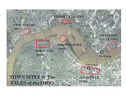
Louisville and Portland Canal
The Louisville and Portland Canal was a canal bypassing the Falls of the Ohio in the Ohio River near Louisville, Kentucky. It opened in 1830, and was operated by the Louisville and Portland Canal Company until 1874, and became the McAlpine Locks and Dam in 1962 after heavy modernization.Although...
in 1825 made the peninsula an island, allowing ships to bypass the Falls and, by extension, Shippingport. In 1828, Louisville incorporated as a city and included Shippingport in its boundaries. Shippingport was hard hit by the loss of its traditional business. An introductory remark in the Louisville Directory of 1844 explained public sentiment towards the canal: "The Louisville and Portland Canal, as constructed and maintained, is precisely one of those improvements for private interests, at the expense of the public good, which is obnoxious to the good of the whole community".
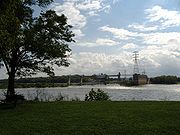
The remnants of the settlement dwindled over the next century as the canal was gradually widened, a hydroelectric plant was built on the island, and the area was devastated by the Ohio River flood of 1937
Ohio River flood of 1937
The Ohio River flood of 1937 took place in late January and February 1937. With damage stretching from Pittsburgh to Cairo, Illinois, one million persons were left homeless, with 385 dead and property losses reaching $500 million...
, which forced most of the remaining families to leave. The federal government acquired the remaining private property there in 1958 to widen the canal, evicting the last families, some of whom had lived there for over a century.
See also
- Fort-on-ShoreFort-on-ShoreFort-on-Shore, built in 1778 by William Linn, was the first on-shore fort on the Ohio River in the area of what is now downtown Louisville, Kentucky. George Rogers Clark had directed Linn to move the militia post to the mainland from its original off-shore location at Corn Island...
- Fort Nelson (Kentucky)Fort Nelson (Kentucky)Fort Nelson, built in 1781 by Richard Chenoweth, was the second on-shore fort on the Ohio River in the area of what is now downtown Louisville, Kentucky. Fort-on-Shore, the downriver and first on-shore fort, had proved to be insufficient barely three years after it was established...
- Geography of Louisville, KentuckyGeography of Louisville, KentuckyLouisville is a city in Jefferson County, Kentucky. It is located at the Falls of the Ohio River.Louisville is located at . According to the U.S. Census Bureau, Louisville Metro has a total area of 1,032 km²...
- History of Louisville, KentuckyHistory of Louisville, KentuckyThe history of Louisville, Kentucky spans hundreds of years, with thousands of years of human habitation. The area's geography and location on the Ohio River attracted people from the earliest times. The city is located at the Falls of the Ohio River...
- Portland, LouisvillePortland, LouisvillePortland is a neighborhood and former independent town two miles northwest of downtown Louisville, Kentucky. In its early days it was the largest of the six major settlements at the Falls of the Ohio River, the others being Shippingport and Louisville in Kentucky and New Albany, Clarksville, and...
External links
- Historic Maps of Louisville/Jefferson County, Kentucky from the University of Louisville Libraries. Includes street maps of Shippingport prior to razing.
- A Brief History of Shippingport Island, Kentucky