

Sherburne Complex Wildlife Management Area (Louisiana)
Encyclopedia
Louisiana Department of Wildlife and Fisheries
The Louisiana Department of Wildlife and Fisheries is a state agency of Louisiana that maintains state parks and wildlife and fishery areas. The agency has its headquarters in Baton Rouge.-External links:*...
(LDWF), and the U.S. Army Corps of Engineers that began in 1983. The area consists of 44000 acres (178.1 km²), and is managed by the Louisiana Department of Wildlife and Fisheries
Louisiana Department of Wildlife and Fisheries
The Louisiana Department of Wildlife and Fisheries is a state agency of Louisiana that maintains state parks and wildlife and fishery areas. The agency has its headquarters in Baton Rouge.-External links:*...
. The complex is located in the Morganza Flood way system, of the Atchafalaya Basin
Atchafalaya Basin
The Atchafalaya Basin, or Atchafalaya Swamp, is the largest swamp in the United States. Located in south central Louisiana, it is a combination of wetlands and river delta area where the Atchafalaya River and the Gulf of Mexico converge. The river stretches from near Simmesport in the north...
, about 30 miles (48.3 km) west of Baton Rouge, Louisiana
Baton Rouge, Louisiana
Baton Rouge is the capital of the U.S. state of Louisiana. It is located in East Baton Rouge Parish and is the second-largest city in the state.Baton Rouge is a major industrial, petrochemical, medical, and research center of the American South...
and actually extends a little south of the I-10
Interstate 10
Interstate 10 is the fourth-longest Interstate Highway in the United States, after I-90, I-80, and I-40. It is the southernmost east–west, coast-to-coast Interstate Highway, although I-4 and I-8 are further south. It stretches from the Pacific Ocean at State Route 1 in Santa Monica,...
Atchafalaya Basin Bridge
Atchafalaya Basin Bridge
The Atchafalaya Basin Bridge is a pair of parallel bridges in the US state of Louisiana between Baton Rouge and Lafayette which carries Interstate 10 over the Atchafalaya Basin. With a total length of or 18.2 miles, it is the fourteenth longest bridge in the world by total length.The bridge...
at Whiskey Bay, Louisiana. The bridge crosses the Whiskey Bay Pilot Channel. Located on the graveled LA 975
Louisiana Highway 975
Louisiana Highway 975 is a gravel state highway in central Louisiana. It runs north–south for . The southern terminus is at Whiskey Bay in Iberville Parish and the northern terminus is east of Krotz Springs at a junction with U.S. Route 190 and the north, south LA 973, in Point Coupee, Parish...
, the west boundary is on the east side of the Atchafalaya River
Atchafalaya River
The Atchafalaya River is a distributary of the Mississippi River and Red River in south central Louisiana in the United States. It flows south, just west of the Mississippi River....
with the east boundary being the East Protection Levee. The complex stretches just north of old highway 190, and a short distance to the south of I-10. The nearest town is Krotz Springs
Krotz Springs, Louisiana
Krotz Springs is a town in St. Landry Parish, Louisiana on the Atchafalaya River. The population was 1,219 at the 2000 census. It is part of the Opelousas–Eunice Micropolitan Statistical Area.-History:...
to the north off US 190
U.S. Route 190
U.S. Route 190, also known as the Ronald Reagan Memorial Highway, is an east–west United States highway in Louisiana and Texas. It evolved from the shortest of intrastate routes in 1926 to a length comparable to a main Interstate Highway route, leading from the swamps and pine forests of...
.
History
The Atchafalaya Basin is in the Lower Mississippi RiverLower Mississippi River
The Lower Mississippi River is the portion of the Mississippi River downstream of Cairo, Illinois. From the confluence of the Ohio River and Upper Mississippi River at Cairo, the Lower flows just under 1600 kilometers to the Gulf of Mexico...
area of the Mississippi River Delta
Mississippi River Delta
The Mississippi River Delta is the modern area of land built up by alluvium deposited by the Mississippi River as it slows down and enters the Gulf of Mexico...
. The culmination of events that eventually led to the existence of wildlife management areas in the Basin in general and the Shereburne Complex in particular began after the Great Flood of 1844
Great Flood of 1844
The Great Flood of 1844 is the biggest flood ever recorded on the Missouri River and Upper Mississippi River, in North America, in terms of discharge.The impact was not as great as subsequent floods because of the small population in the region at the time...
and 1851
Flood of 1851
The Great Flood of 1851 occurred after record-setting rainfalls across the U.S. Midwest and Plains from May to August, 1851. Hardest hit was the State of Iowa, with significant flooding extending to the Lower Mississippi River basin. Historical evidence suggest flooding occurred in the eastern...
. The Great Flood of 1927
Great Mississippi Flood of 1927
The Great Mississippi Flood of 1927 was the most destructive river flood in the history of the United States.-Events:The flood began when heavy rains pounded the central basin of the Mississippi in the summer of 1926. By September, the Mississippi's tributaries in Kansas and Iowa were swollen to...
, prompted the Louisiana Legislature to pass several flood
Flood Control Act
There are multiple laws known as the Flood Control Act. Typically, they are administered by the United States Army Corps of Engineers:-List of Flood Control Acts:*Flood Control Act of 1917...
control
Flood control
In communications, flood control is a feature of many communication protocols designed to prevent overwhelming of a destination receiver. Such controls can be implemented either in software or in hardware, and will often request that the message be resent after the receiver has finished...
bills, including the Flood Control Act of 1928
Flood Control Act of 1928
The Flood Control Act of 1928 authorized the U.S. Army Corps of Engineers to design and construct projects for the control of floods on the Mississippi River and its tributaries as well as the Sacramento River in California. It was sponsored by Sen. Wesley L. Jones of Washington and Rep. Frank R...
, as well as Mississippi River & Tributaries (MR&T) Project, The result was the Atchafalaya Basin Floodway system, channelization (Whiskey Bay cutoff), and bank stabilization projects. During the 1930s an 1940's extensive dredging was performed on the Atchafalaya. In 1954, after the Great Flood of 1951
Great Flood of 1951
In mid-July 1951, heavy rains led to a great rise of water in the Kansas River and other surrounding areas. Flooding resulted in the Kansas, Neosho, Marais Des Cygnes, and Verdigris river basins. The damage in June and July 1951 exceeded $935 million dollars in an area covering eastern Kansas and...
, major dredging was resumed by the Corps. In 1963 the Old River
Old River (Louisiana)
Old River, or Raccourci Old River, is a long ox-bow lake located in northern Pointe Coupee Parish and western West Feliciana Parish in Louisiana, USA. It encompassess approximately ....
control structure was built to prevent the capture of the Mississippi by the Atchafalaya. In 1968, because of environmental concerns
Environmental issue
Environmental issues are negative aspects of human activity on the biophysical environment. Environmentalism, a social and environmental movement that started in the 1960s, addresses environmental issues through advocacy, education and activism.-Types:...
as well as a lack of funds, dredging was discontinued. In 1972 the Louisiana Congress enacted act 365 that established the Atchfalaya Basin Division, within the Department of Public Works. The Corps was directed to develop a plan for the Atchafalaya Basin which was completed in 1982 and became the "Atchafalaya Basin Floodway System Project". (ABFS) In 1983, 10232 acres (41.4 km²) were purchased by the state for the creation of the Sherburne Wildlife Management Area. In 1985, Louisiana Public Law 99-88 was enacted to authorize a multipurpose plan.
State authorization
In 1986, the United States CongressUnited States Congress
The United States Congress is the bicameral legislature of the federal government of the United States, consisting of the Senate and the House of Representatives. The Congress meets in the United States Capitol in Washington, D.C....
approved $250.000.000 towards the creation of the Atchafalaya Basin Program and Louisiana Public Law 99-662, section 906, stated the plan to be of National
Nation
A nation may refer to a community of people who share a common language, culture, ethnicity, descent, and/or history. In this definition, a nation has no physical borders. However, it can also refer to people who share a common territory and government irrespective of their ethnic make-up...
interests. Governor Foster
Murphy J. Foster, Jr.
Murphy James "Mike" Foster, Jr. served as 53rd Governor of Louisiana from January 1996 until January 2004. Foster's father was Murphy J. Foster, Jr., but Mike Foster uses "Jr." even though he is technically Murphy J. Foster, III. Foster is a businessman, landowner, and sportsman in St...
appointed the Louisiana Department of Natural Resources to work with the Corps of Engineers to produce the "Atchafalaya Basin Master Plan" for the development of the basin. In 1988 a plan was implemented and the current alliance was formed (Section 4.41-B of the Master Plan) creating the Sherburne Complex.
Sherburne Complex
The Sherburne Complex, combines the Sherburne Wildlife Management Area (WMA), Atchafalaya National Wildlife RefugeAtchafalaya National Wildlife Refuge
The Atchafalaya National Wildlife Refuge is located about west of Baton Rouge, Louisiana and one mile east of Krotz Springs, Louisiana lies just east of the Atchafalaya River...
, and the U.S. Army Corps of Engineers, Bayou Des Ourses (Bayou of the Bears), with the intent of conservation and management of all fish and wildlife within the boundaries of the complex. The entire area is classified as "bottomland hardwoods". The area contains swamps, overflow lakes, and many bayou
Bayou
A bayou is an American term for a body of water typically found in flat, low-lying areas, and can refer either to an extremely slow-moving stream or river , or to a marshy lake or wetland. The name "bayou" can also refer to creeks that see level changes due to tides and hold brackish water which...
s. This provides opportunities for scientific research, environmental education
Environmental education
Environmental education refers to organized efforts to teach about how natural environments function and, particularly, how human beings can manage their behavior and ecosystems in order to live sustainably. The term is often used to imply education within the school system, from primary to...
, and fish and wildlife oriented recreation. The three combined areas offer ATV
All-terrain vehicle
An all-terrain vehicle , also known as a quad, quad bike, three wheeler, or four wheeler, is defined by the American National Standards Institute as a vehicle that travels on low pressure tires, with a seat that is straddled by the operator, along with handlebars for steering control...
trails, two campgrounds, a shooting range and boat launches. There is also a 17 miles (27.4 km) marked paddling trail that lets visitors tour the bayou without a guide. Recreations also includes birding
Birdwatching
Birdwatching or birding is the observation of birds as a recreational activity. It can be done with the naked eye, through a visual enhancement device like binoculars and telescopes, or by listening for bird sounds. Birding often involves a significant auditory component, as many bird species are...
and nature
Nature
Nature, in the broadest sense, is equivalent to the natural world, physical world, or material world. "Nature" refers to the phenomena of the physical world, and also to life in general...
watching, hunting
Hunting
Hunting is the practice of pursuing any living thing, usually wildlife, for food, recreation, or trade. In present-day use, the term refers to lawful hunting, as distinguished from poaching, which is the killing, trapping or capture of the hunted species contrary to applicable law...
, fishing
Fishing
Fishing is the activity of trying to catch wild fish. Fish are normally caught in the wild. Techniques for catching fish include hand gathering, spearing, netting, angling and trapping....
, trapping
Trapping
Trapping may refer to:* Animal trapping, the remote capture of animals* Trapping , a fighting technique and range* Trap , a color management technique* Mantrap, a security device...
, camping
Camping
Camping is an outdoor recreational activity. The participants leave urban areas, their home region, or civilization and enjoy nature while spending one or several nights outdoors, usually at a campsite. Camping may involve the use of a tent, caravan, motorhome, cabin, a primitive structure, or no...
, and nature photography
Nature photography
Nature photography refers to a wide range of photography taken outdoors and devoted to displaying natural elements such as landscapes, wildlife, plants, and close-ups of natural scenes and textures...
, all complemented by all-weather roads.
Sherburne WMA
11780 acres (47.7 km²) are owned by The Louisiana Department of Wildlife and Fisheries. The headquarters is located 3 miles (4.8 km) south of Krotz Springs on LA 975 in Point Coupe Parish, 15 miles (24.1 km) north of I-10. The office is the site of the Sherburne ghost townGhost town
A ghost town is an abandoned town or city. A town often becomes a ghost town because the economic activity that supported it has failed, or due to natural or human-caused disasters such as floods, government actions, uncontrolled lawlessness, war, or nuclear disasters...
, that was a logging town from the 1880s to the 1930s, and ceased to exist after the timber was exhausted.
Atchafalaya National Wildlife Refuge
An area of 15220 acres (61.6 km²), set aside as a National Wildlife RefugeNational Wildlife Refuge
National Wildlife Refuge is a designation for certain protected areas of the United States managed by the United States Fish and Wildlife Service. The National Wildlife Refuge System is the world's premiere system of public lands and waters set aside to conserve America's fish, wildlife and plants...
, established in 1986, is part of the complex. Atchafalaya is a Choctaw
Choctaw
The Choctaw are a Native American people originally from the Southeastern United States...
Native American
Indigenous peoples of the Americas
The indigenous peoples of the Americas are the pre-Columbian inhabitants of North and South America, their descendants and other ethnic groups who are identified with those peoples. Indigenous peoples are known in Canada as Aboriginal peoples, and in the United States as Native Americans...
word; “Hacha” for river and “falaia” for long, or "Long River". All persons older than 16 or younger than 60 using wildlife management areas in the state of Louisiana, including the refuge, for any reason other than just traveling LA 975 must purchase a Wild Louisiana Stamp, hunting
Hunting license
A hunting license is a regulatory or legal mechanism to control recreational and sports hunting.Hunting may be regulated informally by "unwritten law", "self restraint", or "morality" and by laws "enforced by government authority."...
, or fishing license
License
The verb license or grant licence means to give permission. The noun license or licence refers to that permission as well as to the document recording that permission.A license may be granted by a party to another party as an element of an agreement...
, or pay a daily charge of $2.00.
Bayou Des Ourses
An area of 17000 acres (68.8 km²) is owned by the U.S. Army Corps of Engineers. The name means Bayou of the Bears and is across the Atchafalaya River from 28500 acres (115.3 km²) of Corps land called Indian Bayou. The area also includes the South Farm Unit.Atchafalaya Basin
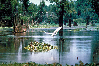
The combined area of the Sherburne Complex is part of the Atchafalaya Basin, the nation’s largest river swamp, containing almost one million acres (4,000 km²). The basin begins near SimmesportSimmesport, Louisiana
Simmesport is a town in Avoyelles Parish, Louisiana, United States. The population was 2,239 at the 2000 census.During the American Civil War, Union General Nathaniel P. Banks was superseded in command by E.R.S. Canby. General Ulysses S. Grant had sought Banks' removal for months, but U.S....
and stretches some 140 miles (225.3 km) southward to the Gulf of Mexico. Currently, the Atchafalaya Basin is bound by natural ridges formed by levee building along active and abandoned courses of the Mississippi River. There are around 60 species of reptiles and amphibians, along with over 250 species of birds, including the American Bald Eagle, Ivory-billed Woodpecker
Ivory-billed Woodpecker
The Ivory-billed Woodpecker is or was one of the largest woodpeckers in the world, at roughly 20 inches in length and 30 inches in wingspan. It was native to the virgin forests of the southeastern United States...
and the Peregrine Falcon
Peregrine Falcon
The Peregrine Falcon , also known as the Peregrine, and historically as the Duck Hawk in North America, is a widespread bird of prey in the family Falconidae. A large, crow-sized falcon, it has a blue-gray back, barred white underparts, and a black head and "moustache"...
can be found in this productive region. Many types of animal life and nearly 100 different species of fish and aquatic life can also be found in the basin.
Oil and gas
There are extensive gas pipe lines with names such as, Gulf Central Pipeline, Dixie Pipeline, Dow Pipeline, Gas Gathering Pipeline, as well as Oil wells, located in the area.Controversy
Since 2001 and the controversy over road tree right-of-way clear cutting for oil wells, many agencies and organizations give input, over-site, and management assistance to the Louisiana Department of Wildlife and Fisheries concerning the protection and future of the complex. Right of way clearings for a new road, to allow access to oil wells, allowed cutting of kite nesting trees at the height of Neotropical migrantMigrant
Migrant may refer to:*Immigration and emigration, the migration of humans*Bird migration*Migrant worker*Migrant literature...
breeding season
Breeding season
The breeding season is the most suitable season, usually with favourable conditions and abundant food and water, for breeding among some wild animals and birds . Species with a breeding season have naturally evolved to have sexual intercourse during a certain time of year in order to achieve the...
. The results, including a meeting at the Sherburne WMA headquarters August 14, 2001, resulted in many changes in the policies of the complex including that there will be no further implementation of forestry prescriptions during the breeding season. The Louisiana Natural Heritage Program, within the LDWF, is part of the Nature Conservancy, along with other organizations, with the responsibility of ensuring that the protection of the natural integrity of the complex is maintain within all aspects of planning and implementation of future decisions.
See also
http://www.wlf.louisiana.gov/sites/default/files/pdf/wma/2763-sherburne/sb.pdf -Sherburne Complex map- List of National Wildlife Refuges: Louisiana
- Interstate 10 in LouisianaInterstate 10 in LouisianaInterstate 10, a major transcontinental Interstate Highway in the Southern U.S., runs across the southern part of the U.S. state of Louisiana. It passes through Lake Charles, Lafayette and Baton Rouge before dipping south of Lake Pontchartrain to serve the New Orleans area and then passing through...
Great Floods
- Great Flood of 1844Great Flood of 1844The Great Flood of 1844 is the biggest flood ever recorded on the Missouri River and Upper Mississippi River, in North America, in terms of discharge.The impact was not as great as subsequent floods because of the small population in the region at the time...
- Flood of 1851Flood of 1851The Great Flood of 1851 occurred after record-setting rainfalls across the U.S. Midwest and Plains from May to August, 1851. Hardest hit was the State of Iowa, with significant flooding extending to the Lower Mississippi River basin. Historical evidence suggest flooding occurred in the eastern...
- Great Flood of 1951Great Flood of 1951In mid-July 1951, heavy rains led to a great rise of water in the Kansas River and other surrounding areas. Flooding resulted in the Kansas, Neosho, Marais Des Cygnes, and Verdigris river basins. The damage in June and July 1951 exceeded $935 million dollars in an area covering eastern Kansas and...
- Great Flood of 1993Great Flood of 1993The Great Mississippi and Missouri Rivers Flood of 1993 occurred in the American Midwest, along the Mississippi and Missouri rivers and their tributaries, from April to October 1993. The flood was among the most costly and devastating to ever occur in the United States, with $15 billion in damages...