
Sheep's Head
Encyclopedia
Bantry Bay
Bantry Bay is a bay located in County Cork, southwest Ireland. The bay runs approximately from northeast to southwest into the Atlantic Ocean. It is approximately 3-to-4 km wide at the head and wide at the entrance....
and Dunmanus Bay
Dunmanus Bay
Dunmanus Bay is a bay in County Cork, Ireland. The bay lies between Mizen Head to the south and Bantry Bay to the north with the small village of Durrus at the head of the bay. The bay is out of the main tidal flow with no significant rivers flowing into it and is little frequented by vessels. On...
in County Cork
County Cork
County Cork is a county in Ireland. It is located in the South-West Region and is also part of the province of Munster. It is named after the city of Cork . Cork County Council is the local authority for the county...
, Ireland
Republic of Ireland
Ireland , described as the Republic of Ireland , is a sovereign state in Europe occupying approximately five-sixths of the island of the same name. Its capital is Dublin. Ireland, which had a population of 4.58 million in 2011, is a constitutional republic governed as a parliamentary democracy,...
.
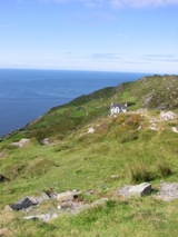
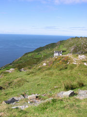
The Sheep's Head Way is an 88 km long-distance trail which follows old tracks and roads around the peninsula from Bantry
Bantry
Bantry is a town on the coast of County Cork, Ireland. It lies on the N71 national secondary road at the head of Bantry Bay, a deep-water gulf extending for 30 km to the west...
to the headland and back. The trail is very accessible and is well signposted (see image on right). The route combines low and rugged hills with coastline and cliffs. The walkway is very straightforward and can be walked during any time between April and October. The trail is divided into eight stages—each representing a half-day's walking. Among those responsible for establishing the Way were Tom Whitty, an American, and local farmer James O’Mahoney.
The peninsula has three villages, Durrus
Durrus
Durrus is a village located in West Cork, six miles from Bantry, County Cork, Ireland. It is situated at the head of the Sheep's Head and Mizen Head Peninsulas. A number of public gardens have been established in the area, including 'Kilvarock' and 'Cois Abhann'...
(six miles from Bantry), Ahakista
Ahakista
Ahakista is located approximately half way along the Sheep's Head peninsula between Durrus and Kilcrohane in west Cork, Ireland. It is a wooded coastal village with a deep and sheltered harbour.-Archaeology :...
(twelve miles from Bantry), and Kilcrohane
Kilcrohane
Kilcrohane is a village in County Cork, Ireland. The last coastal village on the Sheep's Head Peninsula after Durrus and Ahakista, it lies under the 'Shadow of Seefin' - the area's highest mountain and overlooking Dunmanus Bay...
(sixteen miles from Bantry)
Durrus
- Boulder Burial, Ballycomane
- Burial Ground, Brahalish, Clashadoo, Coolcoulaghta, Dunbeacon, Kilvenogue,
- Cairn, Coolcoulaghta, Moulinward
- Castle, Dunbeacon
- Church, Moulinward (In repair 1639 ruins 1699)
- Fulacht Fiadha (Cooking Pit), Dunbeacon, Celtic Iron Age 600 BC - 400 AD
- Graveyard, Moulinward
- Holy Well, Dunbeacon
- Mill Stone, Brahalish
- Promontory fortPromontory fortA promontory fort is a defensive structure located above a steep cliff, often only connected to the mainland by a small neck of land, thus utilizing the topography to reduce the ramparts needed. Although their dating is problematic, most seem to date to the Iron Age...
, Coolcoulaghta (Celtic Iron Age 600 BC - 400 AD) - Ring forts, Ballycomane, Brahalish, Clonee, Drumtahaneen, Dunbeacon, Gortyalassa, Kealties, Rushineska,Celtic Iron Age 600 BC - 400 AD
- Shell Midden, Dunbeacon
- Standing Stones (Gallauns), Ballycomane, Coolcoulaghta (Stone Pair Bronze Age 2200-600BC, Kealties, Parkana)
- Stone Row, Moulinward,Bronze Age 2200-600BC
- Stone Circle, Dunbeacon (Bronze Age 2200-600BC) http://66.249.93.104/search?q=cache:ZY4X-xziNa0J:www.megalithomania.com/show/site/1139+dunbeacon&hl=en&gl=ie&ct=clnk&cd=1, http://66.249.93.104/search?q=cache:iY1t6jKDxXAJ:www.megalithic.co.uk/article.php%3Fsid%3D886+dunbeacon&hl=en&gl=ie&ct=clnk&cd=6
- Tower House (medieval post 1200 AD), Rossmore (O'Mahony|McCarthy?)
Kilcrohane
- Ardahill, Ardintenant, Caher, Caheragh, Derrycluvane, Drumnea, Faunmore, Gortalassa, Gortaneish, Killoveenogue , Knockroe, Raferigeen, Letter East, Rossnacaheragh , Tullig Ringfort Celtic Iron Age 600 BC - 400 AD
- Aughaleigue, Gouladoo, Laherandota, Letter East, Holy well
- Ballytransna, Kilcrohane, Cashel
- Ardaneig, Caher, Farranamanagh, Gortnakilla, Killonoveenogue, Letter West, Kilcrohane, Burial Ground
- Caherurlagh, Holed Stone for healing
- Dooneen, Galladoo, Keelovenogue, Promontory Fort Celtic Iron Age 600 BC - 400 AD
- Dromnea, Bardic School Medieval post 1200 AD, Ornamental Tower erected Lord Bandon, Holy Well (tober na nduanairidhe well of the poets), possible fulach fiadh
- Farranmanagh, Stone Row Bronze Age, Children's Burial Ground, Souterrain, Tower house (O'Daly), Gallaun (standing stone
- Gouladoo, Holy Well
- Letter West, Children's Burial Ground
- Kilcrohane, Souterrain
- Signal Towers, Tooreen
Natural history
- Owen's Island c. 1 hectare
- Sheep's Head, Costal heathland includes rare plants Viola lactea (Pale Dog Violet), Tuberaria (Spotted Rock Rose) and also has choughs and fulmars
External links
- Walk Ireland Official site of the Waymarked Ways of Ireland with map of Sheep's Head Way
- Guided hill walks on the Sheep's Head
- Awarded "EDEN - European Destinations of Excellence" non traditional tourist destination 2009