

Sgat Mór and Sgat Beag
Encyclopedia
Cowal
thumb|Cowal shown within ArgyllCowal is a peninsula in Argyll and Bute in the Scottish Highlands.-Description:The northern part of Cowal is mostly the mountainous Argyll Forest Park. Cowal is separated from the Kintyre peninsula to the west by Loch Fyne, and from Inverclyde and North Ayrshire to...
peninsula on the west coast of Scotland
Scotland
Scotland is a country that is part of the United Kingdom. Occupying the northern third of the island of Great Britain, it shares a border with England to the south and is bounded by the North Sea to the east, the Atlantic Ocean to the north and west, and the North Channel and Irish Sea to the...
.
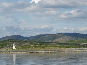
Sgat Mòr lies at at the mouth of Loch Fyne
Loch Fyne
Loch Fyne is a sea loch on the west coast of Argyll and Bute, Scotland. It extends inland from the Sound of Bute, making it the longest of the sea lochs...
. The island rises just 11 metres (36 ft) above sea level and is home to a small lighthouse
Lighthouse
A lighthouse is a tower, building, or other type of structure designed to emit light from a system of lamps and lenses or, in older times, from a fire, and used as an aid to navigation for maritime pilots at sea or on inland waterways....
. The area to the south of the island is the deepest area of water in the Clyde
Firth of Clyde
The Firth of Clyde forms a large area of coastal water, sheltered from the Atlantic Ocean by the Kintyre peninsula which encloses the outer firth in Argyll and Ayrshire, Scotland. The Kilbrannan Sound is a large arm of the Firth of Clyde, separating the Kintyre Peninsula from the Isle of Arran.At...
area. Sgat Mòr is sometimes corrupted into English
English language
English is a West Germanic language that arose in the Anglo-Saxon kingdoms of England and spread into what was to become south-east Scotland under the influence of the Anglian medieval kingdom of Northumbria...
as Skate Island.
Sgat Beag is a similar but slightly smaller island that lies 1 kilometre to the east.