

Seward Peninsula
Encyclopedia
U.S. state
A U.S. state is any one of the 50 federated states of the United States of America that share sovereignty with the federal government. Because of this shared sovereignty, an American is a citizen both of the federal entity and of his or her state of domicile. Four states use the official title of...
of Alaska
Alaska
Alaska is the largest state in the United States by area. It is situated in the northwest extremity of the North American continent, with Canada to the east, the Arctic Ocean to the north, and the Pacific Ocean to the west and south, with Russia further west across the Bering Strait...
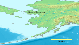
. It projects about 320 kilometres (198.8 mi) into the Bering Sea
Bering Sea
The Bering Sea is a marginal sea of the Pacific Ocean. It comprises a deep water basin, which then rises through a narrow slope into the shallower water above the continental shelves....
between Norton Sound
Norton Sound
Norton Sound is an inlet of the Bering Sea on the western coast of the U.S. state of Alaska, south of the Seward Peninsula. It is about 240 km long and 200 km wide. The Yukon River delta forms a portion of the south shore and water from the Yukon influences this body of water...
, the Bering Strait
Bering Strait
The Bering Strait , known to natives as Imakpik, is a sea strait between Cape Dezhnev, Chukotka Autonomous Okrug, Russia, the easternmost point of the Asian continent and Cape Prince of Wales, Alaska, USA, the westernmost point of the North American continent, with latitude of about 65°40'N,...
, the Chukchi Sea
Chukchi Sea
Chukchi Sea is a marginal sea of the Arctic Ocean. It is bounded on the west by the De Long Strait, off Wrangel Island, and in the east by Point Barrow, Alaska, beyond which lies the Beaufort Sea. The Bering Strait forms its southernmost limit and connects it to the Bering Sea and the Pacific...
, and Kotzebue Sound
Kotzebue Sound
Kotzebue Sound is an arm of the Chukchi Sea in the western region of the U.S. state of Alaska. It is on the north side of the Seward Peninsula and bounded the east by the Baldwin Peninsula. It is long and wide....
, just below the Arctic Circle
Arctic Circle
The Arctic Circle is one of the five major circles of latitude that mark maps of the Earth. For Epoch 2011, it is the parallel of latitude that runs north of the Equator....
. The entire peninsula is about 330 kilometres (205.1 mi) long and 145 km (90 mi)-225 km (140 mi) wide.
The Seward Peninsula was once part of the Bering land bridge
Bering land bridge
The Bering land bridge was a land bridge roughly 1,000 miles wide at its greatest extent, which joined present-day Alaska and eastern Siberia at various times during the Pleistocene ice ages. Like most of Siberia and all of Manchuria, Beringia was not glaciated because snowfall was extremely light...
, a roughly thousand mile wide swath of land connecting Siberia
Siberia
Siberia is an extensive region constituting almost all of Northern Asia. Comprising the central and eastern portion of the Russian Federation, it was part of the Soviet Union from its beginning, as its predecessor states, the Tsardom of Russia and the Russian Empire, conquered it during the 16th...
with mainland Alaska during the Pleistocene Ice Age
Pleistocene
The Pleistocene is the epoch from 2,588,000 to 11,700 years BP that spans the world's recent period of repeated glaciations. The name pleistocene is derived from the Greek and ....
. This land bridge aided in the migration of humans, as well as plant and animal species from Asia to North America. Archeological discoveries throughout the Seward Peninsula show proof that Inupiat Eskimos have been living in the region for thousands of years. Excavations at sites such as the Trail Creek Caves
Trail Creek Caves
The Trail Creek Caves are a group of twelve caves found within the Bering Land Bridge National Preserve on the Seward Peninsula of the U.S. state of Alaska. This is a significant archeological site due to the discovery of several artifacts of ancient hunters. These included stone tools and bone...
and Cape Espenberg in the Bering Land Bridge National Preserve
Bering Land Bridge National Preserve
The Bering Land Bridge National Preserve is one of the most remote United States national park areas, located on the Seward Peninsula. The National Preserve protects a remnant of the Bering Land Bridge that connected Asia with North America more than 13,000 years ago during the Pleistocene ice age...
as well as Cape Denbigh
Cape Denbigh
Cape Denbigh is part of the Seward Peninsula in Eastern Norton Sound in Alaska. It is notable for the Iyatayet Site, an Archaic Stage hunter gather archaeological site....
to the south have provided insight into the timeline of prehistorical migrations from Asia to the Seward Peninsula.
Demographics
Communities on the Seward Peninsula, with 2005 state population estimates:| City | Population |
|---|---|
| Nome Nome, Alaska Nome is a city in the Nome Census Area in the Unorganized Borough of the U.S. state of Alaska, located on the southern Seward Peninsula coast on Norton Sound of the Bering Sea. According to the 2010 Census, the city population was 3,598. Nome was incorporated on April 9, 1901, and was once the... |
3,508 |
| Shishmaref Shishmaref, Alaska Shishmaref is a village in the Nome Census Area, Alaska, United States, located on Sarichef Island in the Chukchi Sea, just north of the Bering Strait and five miles from the mainland. It lies within the Bering Land Bridge National Preserve... |
581 |
| Buckland Buckland, Alaska Buckland is a city in Northwest Arctic Borough, Alaska, United States. At the 2000 census the population was 406.-Geography:Buckland is located at .... |
434 |
| Koyuk Koyuk, Alaska Koyuk is a city in the Nome Census Area, Alaska, United States. The population was 297 at the 2000 census.-Geography:Koyuk is located at... |
350 |
| Brevig Mission Brevig Mission, Alaska Brevig Mission is a city in Nome Census Area, Alaska. The population was 276 at the 2000 census.-Geography:Brevig Mission is located at .... |
327 |
| Elim Elim, Alaska Elim is a city in Nome Census Area, Alaska, United States. At the 2000 census the population was 313.-Geography:Elim is located at .... |
302 |
| Teller Teller, Alaska Teller is a city in Nome Census Area, Alaska, United States. At the 2000 census the population was 268. According to a 2009 estimate, the population had increased by exactly one person.... |
263 |
| White Mountain White Mountain, Alaska White Mountain is a city in Nome Census Area, Alaska, United States. At the 2000 census the population is between 220 and 250. The city is an Iġaluiђmuit Iñupiat village, with historical influences from and relationships with Kawerak and Yupiaq Eskimos. 86.2% of the population is Alaska Native or... |
224 |
| Wales Wales, Alaska Wales is a town in the Nome Census Area, Alaska, United States. At the 2000 census the population was 152. It is the westernmost town on the American mainland.-Geography:... |
151 |
| Golovin Golovin, Alaska Golovin is a city in Nome Census Area, Alaska, United States. At the 2000 census the population was 144.-Geography:Golovin is located at .... |
150 |
| Deering Deering, Alaska Deering is a city in the Northwest Arctic Borough in the U.S. state of Alaska. It is located on a sandy spit on the Seward Peninsula where the Inmachuk River flows into Kotzebue Sound, southwest of Kotzebue.... |
139 |
Other locations on the Seward Peninsula include the mining towns of Council
Council, Alaska
Council is an abandoned townsite in the Nome Census Area in the U.S. state of Alaska.- Geography :Council is located at about , about 57 miles east by northeast of Nome. It is located on the banks of the Niukluk River on the central Seward Peninsula....
, Solomon, Candle, Haycock and Taylor. While still frequented by locals of neighboring communities, there are no longer year round residents in these locations. There is a United States Coast Guard
United States Coast Guard
The United States Coast Guard is a branch of the United States Armed Forces and one of the seven U.S. uniformed services. The Coast Guard is a maritime, military, multi-mission service unique among the military branches for having a maritime law enforcement mission and a federal regulatory agency...
LORAN
LORAN
LORAN is a terrestrial radio navigation system using low frequency radio transmitters in multiple deployment to determine the location and speed of the receiver....
station at Port Clarence
Port Clarence, Alaska
Port Clarence is a census-designated place in Nome Census Area, Alaska. The population was 21 at the 2000 census. It is located on the spit separating the bay of Port Clarence from the Bering Strait.-History:...
. The U.S. Air Force operates a radar
Radar
Radar is an object-detection system which uses radio waves to determine the range, altitude, direction, or speed of objects. It can be used to detect aircraft, ships, spacecraft, guided missiles, motor vehicles, weather formations, and terrain. The radar dish or antenna transmits pulses of radio...
station at the "Tin City" site, 7 miles (11 km) southeast of Wales.
Geography and ecology
The Seward Peninsula has several distinct geologic features. The Devil Mountain LakesDevil Mountain Lakes
Devil Mountain Lakes is a maar in the western part of Alaska. The lake is considered being the largest maar in the world .-Geography:...
on the northern portion of the peninsula are the largest maar
Maar
A maar is a broad, low-relief volcanic crater that is caused by a phreatomagmatic eruption, an explosion caused by groundwater coming into contact with hot lava or magma. A maar characteristically fills with water to form a relatively shallow crater lake. The name comes from the local Moselle...
lakes in the world. They were formed over 21,000 years ago as the result of an underground steam explosion. The Killeak Lakes and White Fish Lake are also volcanic maar lakes of notable size on the northern Seward Peninsula. Four mountain ranges line the southern side of the peninsula, the most prominent being the Kigluaik (or Sawtooth) Mountains. The highest point in the range and the peninsula is the peak of 4714 feet (1,437 m) Mount Osborn
Mount Osborn
Mount Osborn is the highest point in the Kigluaik Mountains, and also on the Seward Peninsula. It is approximately 4714 feet high and is located on the north end of the range. Despite being almost one thousand feet taller, Osborn's fame is matched by Mount Bendeleben because Bendeleben is much...
. Other mountain ranges on the Seward Peninsula include the Bendeleben Mountains
Bendeleben Mountains
The Bendeleben Mountains are a mountain range on the heart of the Seward Peninsula in Nome Census Area, Alaska, United States. This range forms a major divide between drainage basins draining into the Pacific Ocean and the Arctic Ocean. The tallest peak, Mount Bendeleben is 3730 feet tall and is...
, Darby Mountains, and York Mountains. The Lost Jim Lava Flow
Lost Jim Lava Flow
The Lost Jim Lava Flow, located in the heart of the Seward Peninsula, is a Holocene lava flow in the Bering Land Bridge National Preserve. The name originates from a member of a USGS research team who became separated from the rest of the group while mapping the lava flow in 1947. The Lost Jim...
north of Kuzitrin Lake is a lava field formed roughly 1,000 to 2,000 years ago, which covers roughly 88 square miles (228 km²).
Several geothermal hot springs are located throughout the peninsula, including Serpentine Hot Springs, Pilgrim Hot Springs, Granite Mountain, Elim, Clear Creek and Lava Creek.
The Seward Peninsula has several rivers. The largest include the Koyuk
Koyuk River
The Koyuk River is a river on the Seward Peninsula of western Alaska. The river originates in the interior of the peninsula, at the Lost Jim Lava Flow of the Bering Land Bridge National Preserve, where it flows southeast towards the mouth of Norton Bay. The native village of Koyuk is located at...
, Kuzitrin
Kuzitrin River
The Kuzitrin River is a river found on the Seward Peninsula of Northwest Alaska. The river headwaters are at the Lost Jim Lava Flow in the central region of the peninsula, and flows 95 miles west into the Imuruk Basin, which eventually feeds the Bering Sea. Kuzitrin tribuatries include the...
, Niukluk, Fish
Fish River (Alaska)
The Fish River is a 47 mi. long river arising in the Bendeleben Mountains of the U.S. state of Alaska and flowing south to Golovnin Lagoon, then emptying into Golovnin Bay, Norton Sound, and the Bering Sea....
, Tubuktilik, Kiwalik
Kiwalik River
The Kiwalik River is a river found on western Alaska's Seward Peninsula. The headwaters of the river originate in the eastern portion of the peninsula, around Granite Mountain. The river flows north to its mouth at Kiwalik Lagoon, Chukchi Sea...
, Buckland
Buckland River
The Buckland River is a 67 mi. long river in the U.S. state of Alaska. It flows northwest to the Chukchi Sea at Eschscholtz Bay, 40 mi. Southwest of Selawik, Kotzebue-Kobuk Low. It is 67 miles long....
and Agiupuk Rivers. These play a vital role in the subsistence lifestyles of many peninsula residents and ease travel, hunting, and fishing. Most peninsula rivers have at least a small yearly run of several varieties of salmon
Salmon
Salmon is the common name for several species of fish in the family Salmonidae. Several other fish in the same family are called trout; the difference is often said to be that salmon migrate and trout are resident, but this distinction does not strictly hold true...
, as well as Dolly Varden
Dolly Varden
Dolly Varden may refer to:* Dolly Varden , a character in the novel Barnaby Rudge by Charles Dickens. The original usage.* Dolly Vardens , a group of Black women baseball players that comprised the first professional baseball team* Dolly Varden , a musical group from Chicago, Illinois* Dolly Varden...
, Arctic Grayling
Arctic grayling
Arctic grayling is a species of freshwater fish in the salmon family of order Salmoniformes. It comprises five subspecies native to the Nearctic and Palearctic ecozones. T. a. arcticus is widespread throughout the Arctic and Pacific drainages in Canada, Alaska, and Siberia, as well as the upper...
, whitefish
Coregonus
Coregonus is a diverse genus of fish in the salmon family . The type species is the common whitefish . The Coregonus species are known as whitefishes...
of various species, Northern Pike
Northern Pike
The northern pike , is a species of carnivorous fish of the genus Esox...
, and Burbot
Burbot
The burbot is the only gadiform fish inhabiting freshwaters. It is also known as mariah, the lawyer, and eelpout. It is closely related to the marine common ling and the cusk...
. Most rivers on the Seward Peninsula freeze in mid-October; spring break-up usually occurs in mid- to late May.
The Seward Peninsula is the western-most limit of distribution for the Black spruce
Black Spruce
Picea mariana is a species of spruce native to northern North America, from Newfoundland west to Alaska, and south to northern New York, Minnesota and central British Columbia...
, Picea mariana, a dominant overstory species of the region.
Cape Prince of Wales
Cape Prince of Wales
Cape Prince of Wales is the westernmost point on the mainland of the Americas.Located on the Seward Peninsula of the U.S. state of Alaska near the city of Wales, Cape Prince of Wales is the terminus of the Continental Divide, marking the division between the Pacific and Arctic coasts, as well as...
, the westernmost point on the mainland of the Americas, is on the western tip. The cape is only 52 miles (84 km) from Cape Dezhnev
Cape Dezhnev
Cape Dezhnyov or Cape Dezhnev is a cape that forms the eastmost mainland point of Eurasia. It is located on the Chukchi Peninsula in the very thinly populated Chukotka Autonomous Okrug of Russia. This cape is located between the Bering Sea and the Chukchi Sea, across from Cape Prince of Wales in...
, the closest point on the Russian
Russia
Russia or , officially known as both Russia and the Russian Federation , is a country in northern Eurasia. It is a federal semi-presidential republic, comprising 83 federal subjects...
mainland. In August 2011 Russia announced an ambitions project to construct a rail tunnel under the Bering Strait, linking the Seward Peninsula in Alaska with the Chukchi Peninsula
Chukchi Peninsula
The Chukchi Peninsula, Chukotka Peninsula or Chukotski Peninsula , at about 66° N 172° W, is the northeastern extremity of Asia. Its eastern end is at Cape Dezhnev near the village of Uelen. It is bordered by the Chukchi Sea to the north, the Bering Sea to the south, and the Bering Strait to the...
in Russia. If completed, the project would cost an estimated US $65 billion and would be the world's longest tunnel at 103 km (64 mi) long.
The peninsula was named after William H. Seward
William H. Seward
William Henry Seward, Sr. was the 12th Governor of New York, United States Senator and the United States Secretary of State under Abraham Lincoln and Andrew Johnson...
, the United States Secretary of State
United States Secretary of State
The United States Secretary of State is the head of the United States Department of State, concerned with foreign affairs. The Secretary is a member of the Cabinet and the highest-ranking cabinet secretary both in line of succession and order of precedence...
who negotiated the Purchase
Alaska purchase
The Alaska Purchase was the acquisition of the Alaska territory by the United States from Russia in 1867 by a treaty ratified by the Senate. The purchase, made at the initiative of United States Secretary of State William H. Seward, gained of new United States territory...
of Alaska from Russia in 1867.