
September 2007 Sumatra earthquakes
Encyclopedia
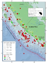
The September 2007 Sumatra earthquakes were a series of megathrust earthquake
s that struck the Java Trench
off the coast of Sumatra
, Indonesia
, three greater than magnitude 7. A series of tsunami
bulletins was issued for the area. The most powerful of the series had a magnitude
of 8.5, which makes it in the top 20 of the largest earthquakes ever recorded on a seismograph.
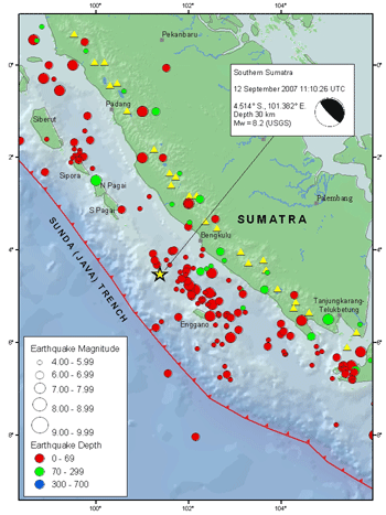
(18:10 local time
) on 12 September 2007, and was an 8.5 Mw
earthquake
on the moment magnitude scale
. It was centered about 34 km underground, at 4.520°S 101.374°E, about 130 km southwest of Bengkulu on the southwest coast of Sumatra
, Indonesia
, and some 600 km west-northwest of Indonesia's capital city, Jakarta
. It was followed by several earthquakes of magnitude 5 through 6 along the same fault, west of Sumatra.
The second largest earthquake, 7.9 Mw
, occurred later the same day at 23:49:04 UTC
(06:49:04 local time the following day). It was centred about 10 km underground, at 2.506°S 100.906°E, some 185 km (115 mi) south-southeast of Padang, Indonesia
and about 205 km northwest of Bengkulu (about 225 km northwest of the magnitude 8.5 earthquake).
After further aftershocks above magnitude 5, a third earthquake, 7.0 Mw
, occurred at 03:35:26 UTC (10:35:26 local time) on 13 September. It was centred about 10 km underground, at 2.160°S 99.851°E, some 165 km south-southwest of Padang and 345 km west-northwest of Bengkulu.
Aftershocks continued into 13 September and 14 September , with more earthquakes ranging up to magnitude 6.4. Most of the aftershocks have been northwest of the original magnitude 8.5 earthquake. A 6.7 struck Southern Sumatra on Sept 20, 2007.
Tidal buoys positioned in the Indian Ocean and other seismic tools have led scientists to issue a series of tsunami bulletins.
earthquake lasted for several minutes. It caused buildings to sway in Jakarta, and some buildings were reported to have collapsed in the city of Bengkulu, Bengkulu Province, about 100 km from the epicenter
. Tremors felt in Jakarta were described as being "violent". It was reported that several high-rise buildings were evacuated. The earthquake also led to a power outage in Bengkulu, which crippled communications. The death toll of the earthquakes is 21 with 88 people injured.
Tremors were felt in neighbouring countries as far away as Southern Thailand
. In Singapore
, which is about 670 km from the epicenter, the tremor was felt at around 11:10 UTC (19:10 local time
). Most of the Central
and Eastern
part of Singapore
has felt the tremor. In Peninsular Malaysia
, tremors were reported after 19:15 local time
, including Kuala Lumpur
, Putrajaya
, Johor Bahru
, Malacca
and Penang
. Like Singapore, the tremors were most severe on high-rises, resulting in minor panic and evacuations. No casualties were reported in the country, as of 13 September.
was generated. A total of 4 tsunami alerts were issued in 24 hours. After the first, and largest, earthquake, the Pacific Tsunami Warning Centre issued a tsunami alert for much of the Indian Ocean basin. A tsunami approximately 1 metre high was reported at Padang, Indonesia
. A small tsunami, some 15 cm high, was reported at the Cocos Islands. Sumatra was taken off tsunami alert after two hours.
Tsunami warnings were also issued in India and other countries around the Indian Ocean soon after the earthquake. The Government of India
asked the states of Tamil Nadu
, Kerala
, Andhra Pradesh
and the union territories of Andaman and Nicobar Islands and Pondicherry to be on high alert. By late 12 September, the tsunami warning was recalled. Similarly, a tsunami alert was issued in Peninsular Malaysia
at 20:50 (local time
) for the coastal areas of Perlis
, Kedah
, Perak
and Penang
; the alert was lifted two hours later. However, Malaysian authorities had detected a 1-3m high tsunami heading away from the epicenter of the earthquake.
 According to the US Geological Survey, the earthquake was caused by thrust fault
ing on the boundary between the Australian Plate
and the Sunda Plate
. At the location of the earthquake, offshore of the west coast of Sumatra, the Australia plate moves northeast with respect to the Sunda Plate at a velocity
of about 69 mm/year, oblique to the orientation of the plate boundary. The component of plate motion perpendicular to the boundary produces thrust faulting on the offshore plate-boundary.
The magnitude 7.9 earthquake was also a result of thrust faulting on the same plate boundary. It occurred about 225 km northwest of the magnitude 8.4 earthquake, at the northern end of the aftershock zone.
The magnitude 8.5 earthquake was the most powerful earthquake of 2007 to date, more powerful than the two March 2007 Sumatra earthquakes
nearby and the 2007 Peru earthquake
. It was the second most powerful earthquake since the magnitude 9.3 2004 Indian Ocean earthquake
, exceeded only by the magnitude 8.6 2005 Sumatra earthquake
. The two largest earthquakes were the fourth and fifth earthquakes with magnitude 7.9 or greater to have occurred on or near the plate boundaries offshore of western Sumatra in 7 years, the others being the magnitude 7.9 earthquake
of 4 June 2000; the magnitude 9.3 2004 Indian Ocean earthquake
on 26 December 2004; and the magnitude 8.6 2005 Sumatra earthquake
on 28 March 2005.
According to data from the Japanese PALSAR microwave
sensor aboard the Daichi(ALOS)
satellite
, South Pagai
Island was uplifted, creating 6 new islands, and exposing previously submerged coral reefs as well as enlarging existing islands.
Earthquake
An earthquake is the result of a sudden release of energy in the Earth's crust that creates seismic waves. The seismicity, seismism or seismic activity of an area refers to the frequency, type and size of earthquakes experienced over a period of time...
s that struck the Java Trench
Java Trench
The Sunda Trench, earlier known as, and sometimes still indicated as the Java Trench, located in the northeastern Indian Ocean, with a length of and a maximum depth of , is the second-deepest point in the Indian Ocean after Diamantina Trench, which is 8,047 metres deep...
off the coast of Sumatra
Sumatra
Sumatra is an island in western Indonesia, westernmost of the Sunda Islands. It is the largest island entirely in Indonesia , and the sixth largest island in the world at 473,481 km2 with a population of 50,365,538...
, Indonesia
Indonesia
Indonesia , officially the Republic of Indonesia , is a country in Southeast Asia and Oceania. Indonesia is an archipelago comprising approximately 13,000 islands. It has 33 provinces with over 238 million people, and is the world's fourth most populous country. Indonesia is a republic, with an...
, three greater than magnitude 7. A series of tsunami
Tsunami
A tsunami is a series of water waves caused by the displacement of a large volume of a body of water, typically an ocean or a large lake...
bulletins was issued for the area. The most powerful of the series had a magnitude
Moment magnitude scale
The moment magnitude scale is used by seismologists to measure the size of earthquakes in terms of the energy released. The magnitude is based on the seismic moment of the earthquake, which is equal to the rigidity of the Earth multiplied by the average amount of slip on the fault and the size of...
of 8.5, which makes it in the top 20 of the largest earthquakes ever recorded on a seismograph.
Timeline
The first earthquake occurred at 11:10:26 UTCCoordinated Universal Time
Coordinated Universal Time is the primary time standard by which the world regulates clocks and time. It is one of several closely related successors to Greenwich Mean Time. Computer servers, online services and other entities that rely on having a universally accepted time use UTC for that purpose...
(18:10 local time
UTC+7
UTC+07:00 is an identifier for a time offset from UTC of +07:00. In ISO 8601 the associated time would be written as .Also known as Indochina Time , it is used in:-As standard time :*Australia...
) on 12 September 2007, and was an 8.5 Mw
Moment magnitude scale
The moment magnitude scale is used by seismologists to measure the size of earthquakes in terms of the energy released. The magnitude is based on the seismic moment of the earthquake, which is equal to the rigidity of the Earth multiplied by the average amount of slip on the fault and the size of...
earthquake
Earthquake
An earthquake is the result of a sudden release of energy in the Earth's crust that creates seismic waves. The seismicity, seismism or seismic activity of an area refers to the frequency, type and size of earthquakes experienced over a period of time...
on the moment magnitude scale
Moment magnitude scale
The moment magnitude scale is used by seismologists to measure the size of earthquakes in terms of the energy released. The magnitude is based on the seismic moment of the earthquake, which is equal to the rigidity of the Earth multiplied by the average amount of slip on the fault and the size of...
. It was centered about 34 km underground, at 4.520°S 101.374°E, about 130 km southwest of Bengkulu on the southwest coast of Sumatra
Sumatra
Sumatra is an island in western Indonesia, westernmost of the Sunda Islands. It is the largest island entirely in Indonesia , and the sixth largest island in the world at 473,481 km2 with a population of 50,365,538...
, Indonesia
Indonesia
Indonesia , officially the Republic of Indonesia , is a country in Southeast Asia and Oceania. Indonesia is an archipelago comprising approximately 13,000 islands. It has 33 provinces with over 238 million people, and is the world's fourth most populous country. Indonesia is a republic, with an...
, and some 600 km west-northwest of Indonesia's capital city, Jakarta
Jakarta
Jakarta is the capital and largest city of Indonesia. Officially known as the Special Capital Territory of Jakarta, it is located on the northwest coast of Java, has an area of , and a population of 9,580,000. Jakarta is the country's economic, cultural and political centre...
. It was followed by several earthquakes of magnitude 5 through 6 along the same fault, west of Sumatra.
The second largest earthquake, 7.9 Mw
Moment magnitude scale
The moment magnitude scale is used by seismologists to measure the size of earthquakes in terms of the energy released. The magnitude is based on the seismic moment of the earthquake, which is equal to the rigidity of the Earth multiplied by the average amount of slip on the fault and the size of...
, occurred later the same day at 23:49:04 UTC
Coordinated Universal Time
Coordinated Universal Time is the primary time standard by which the world regulates clocks and time. It is one of several closely related successors to Greenwich Mean Time. Computer servers, online services and other entities that rely on having a universally accepted time use UTC for that purpose...
(06:49:04 local time the following day). It was centred about 10 km underground, at 2.506°S 100.906°E, some 185 km (115 mi) south-southeast of Padang, Indonesia
Padang, Indonesia
Padang is the capital and largest city of West Sumatra, Indonesia. It is located on the western coast of Sumatra at . It has an area of and a population of over 833,000 people at the 2010 Census.-History:...
and about 205 km northwest of Bengkulu (about 225 km northwest of the magnitude 8.5 earthquake).
After further aftershocks above magnitude 5, a third earthquake, 7.0 Mw
Moment magnitude scale
The moment magnitude scale is used by seismologists to measure the size of earthquakes in terms of the energy released. The magnitude is based on the seismic moment of the earthquake, which is equal to the rigidity of the Earth multiplied by the average amount of slip on the fault and the size of...
, occurred at 03:35:26 UTC (10:35:26 local time) on 13 September. It was centred about 10 km underground, at 2.160°S 99.851°E, some 165 km south-southwest of Padang and 345 km west-northwest of Bengkulu.
Aftershocks continued into 13 September and 14 September , with more earthquakes ranging up to magnitude 6.4. Most of the aftershocks have been northwest of the original magnitude 8.5 earthquake. A 6.7 struck Southern Sumatra on Sept 20, 2007.
Tidal buoys positioned in the Indian Ocean and other seismic tools have led scientists to issue a series of tsunami bulletins.
Effects
The tremors of the 8.5 MwMoment magnitude scale
The moment magnitude scale is used by seismologists to measure the size of earthquakes in terms of the energy released. The magnitude is based on the seismic moment of the earthquake, which is equal to the rigidity of the Earth multiplied by the average amount of slip on the fault and the size of...
earthquake lasted for several minutes. It caused buildings to sway in Jakarta, and some buildings were reported to have collapsed in the city of Bengkulu, Bengkulu Province, about 100 km from the epicenter
Epicenter
The epicenter or epicentre is the point on the Earth's surface that is directly above the hypocenter or focus, the point where an earthquake or underground explosion originates...
. Tremors felt in Jakarta were described as being "violent". It was reported that several high-rise buildings were evacuated. The earthquake also led to a power outage in Bengkulu, which crippled communications. The death toll of the earthquakes is 21 with 88 people injured.
Tremors were felt in neighbouring countries as far away as Southern Thailand
Southern Thailand
Southern Thailand is a distinct region of Thailand, connected with the Central region by the narrow Kra Isthmus.-Geography:Southern Thailand is located on the Malay Peninsula, with an area around 70,713 km², bounded to the north by Kra Isthmus as the narrowest part of the peninsula. The...
. In Singapore
Singapore
Singapore , officially the Republic of Singapore, is a Southeast Asian city-state off the southern tip of the Malay Peninsula, north of the equator. An island country made up of 63 islands, it is separated from Malaysia by the Straits of Johor to its north and from Indonesia's Riau Islands by the...
, which is about 670 km from the epicenter, the tremor was felt at around 11:10 UTC (19:10 local time
Singapore Standard Time
Singapore Standard Time or Singapore Time based in Singapore uses a time zone eight hours in advance of UTC .- History :...
). Most of the Central
Central Region, Singapore
The Central Region of Singapore is one of the five regions in the city-state. Comprising 13,150 hectares of land area, it includes 11 Planning Areas within the Central Area which is the immediate vicinity of the Singapore's central business district, as well as another 11 more outside it.Although...
and Eastern
East Region, Singapore
The East Region of Singapore is one of the five regions in the city-state. It includes six urban planning areas. As its name implies, it is the easternmost region of Singapore.The land area is about 11,000 hectares.-Urban planning areas in East Region:...
part of Singapore
Singapore
Singapore , officially the Republic of Singapore, is a Southeast Asian city-state off the southern tip of the Malay Peninsula, north of the equator. An island country made up of 63 islands, it is separated from Malaysia by the Straits of Johor to its north and from Indonesia's Riau Islands by the...
has felt the tremor. In Peninsular Malaysia
Peninsular Malaysia
Peninsular Malaysia , also known as West Malaysia , is the part of Malaysia which lies on the Malay Peninsula. Its area is . It shares a land border with Thailand in the north. To the south is the island of Singapore. Across the Strait of Malacca to the west lies the island of Sumatra...
, tremors were reported after 19:15 local time
Malaysian Standard Time
Malaysia Standard Time or Waktu Piawai Malaysia or Malaysia Time is a standard time used in Malaysia. It is 8 hours ahead of Greenwich Mean Time and Coordinated Universal Time. The local mean time in Kuala Lumpur was originally GMT+06:46:48...
, including Kuala Lumpur
Kuala Lumpur
Kuala Lumpur is the capital and the second largest city in Malaysia by population. The city proper, making up an area of , has a population of 1.4 million as of 2010. Greater Kuala Lumpur, also known as the Klang Valley, is an urban agglomeration of 7.2 million...
, Putrajaya
Putrajaya
Putrajaya is a planned city, located 25km south of Kuala Lumpur, that serves as the federal administrative centre of Malaysia. The seat of government was shifted in 1999 from Kuala Lumpur to Putrajaya, due to the overcrowding and congestion in the Kuala Lumpur areas...
, Johor Bahru
Johor Bahru
Johor Bahru is the capital city of Johor in southern Malaysia. Johor Bahru is the southernmost city of the Eurasian mainland...
, Malacca
Malacca
Malacca , dubbed The Historic State or Negeri Bersejarah among locals) is the third smallest Malaysian state, after Perlis and Penang. It is located in the southern region of the Malay Peninsula, on the Straits of Malacca. It borders Negeri Sembilan to the north and the state of Johor to the south...
and Penang
Penang
Penang is a state in Malaysia and the name of its constituent island, located on the northwest coast of Peninsular Malaysia by the Strait of Malacca. It is bordered by Kedah in the north and east, and Perak in the south. Penang is the second smallest Malaysian state in area after Perlis, and the...
. Like Singapore, the tremors were most severe on high-rises, resulting in minor panic and evacuations. No casualties were reported in the country, as of 13 September.
Tsunami
Sea level readings indicated that a tsunamiTsunami
A tsunami is a series of water waves caused by the displacement of a large volume of a body of water, typically an ocean or a large lake...
was generated. A total of 4 tsunami alerts were issued in 24 hours. After the first, and largest, earthquake, the Pacific Tsunami Warning Centre issued a tsunami alert for much of the Indian Ocean basin. A tsunami approximately 1 metre high was reported at Padang, Indonesia
Padang, Indonesia
Padang is the capital and largest city of West Sumatra, Indonesia. It is located on the western coast of Sumatra at . It has an area of and a population of over 833,000 people at the 2010 Census.-History:...
. A small tsunami, some 15 cm high, was reported at the Cocos Islands. Sumatra was taken off tsunami alert after two hours.
Tsunami warnings were also issued in India and other countries around the Indian Ocean soon after the earthquake. The Government of India
Government of India
The Government of India, officially known as the Union Government, and also known as the Central Government, was established by the Constitution of India, and is the governing authority of the union of 28 states and seven union territories, collectively called the Republic of India...
asked the states of Tamil Nadu
Tamil Nadu
Tamil Nadu is one of the 28 states of India. Its capital and largest city is Chennai. Tamil Nadu lies in the southernmost part of the Indian Peninsula and is bordered by the union territory of Pondicherry, and the states of Kerala, Karnataka, and Andhra Pradesh...
, Kerala
Kerala
or Keralam is an Indian state located on the Malabar coast of south-west India. It was created on 1 November 1956 by the States Reorganisation Act by combining various Malayalam speaking regions....
, Andhra Pradesh
Andhra Pradesh
Andhra Pradesh , is one of the 28 states of India, situated on the southeastern coast of India. It is India's fourth largest state by area and fifth largest by population. Its capital and largest city by population is Hyderabad.The total GDP of Andhra Pradesh is $100 billion and is ranked third...
and the union territories of Andaman and Nicobar Islands and Pondicherry to be on high alert. By late 12 September, the tsunami warning was recalled. Similarly, a tsunami alert was issued in Peninsular Malaysia
Peninsular Malaysia
Peninsular Malaysia , also known as West Malaysia , is the part of Malaysia which lies on the Malay Peninsula. Its area is . It shares a land border with Thailand in the north. To the south is the island of Singapore. Across the Strait of Malacca to the west lies the island of Sumatra...
at 20:50 (local time
Malaysian Standard Time
Malaysia Standard Time or Waktu Piawai Malaysia or Malaysia Time is a standard time used in Malaysia. It is 8 hours ahead of Greenwich Mean Time and Coordinated Universal Time. The local mean time in Kuala Lumpur was originally GMT+06:46:48...
) for the coastal areas of Perlis
Perlis
Perlis is the smallest state in Malaysia. It lies at the northern part of the west coast of Peninsular Malaysia and has Satun and Songkhla Provinces of Thailand on its northern border. It is bordered by the state of Kedah to the south...
, Kedah
Kedah
Kedah is a state of Malaysia, located in the northwestern part of Peninsular Malaysia. The state covers a total area of over 9,000 km², and it consists of the mainland and Langkawi. The mainland has a relatively flat terrain, which is used to grow rice...
, Perak
Perak
Perak , one of the 13 states of Malaysia, is the second largest state in the Peninsular Malaysia bordering Kedah and Yala Province of Thailand to the north, Penang to the northwest, Kelantan and Pahang to the east, Selangor the Strait of Malacca to the south and west.Perak means silver in Malay...
and Penang
Penang
Penang is a state in Malaysia and the name of its constituent island, located on the northwest coast of Peninsular Malaysia by the Strait of Malacca. It is bordered by Kedah in the north and east, and Perak in the south. Penang is the second smallest Malaysian state in area after Perlis, and the...
; the alert was lifted two hours later. However, Malaysian authorities had detected a 1-3m high tsunami heading away from the epicenter of the earthquake.
Tectonic summary
Thrust fault
A thrust fault is a type of fault, or break in the Earth's crust across which there has been relative movement, in which rocks of lower stratigraphic position are pushed up and over higher strata. They are often recognized because they place older rocks above younger...
ing on the boundary between the Australian Plate
Indo-Australian Plate
The Indo-Australian Plate is a major tectonic plate that includes the continent of Australia and surrounding ocean, and extends northwest to include the Indian subcontinent and adjacent waters...
and the Sunda Plate
Eurasian Plate
The Eurasian Plate is a tectonic plate which includes most of the continent of Eurasia , with the notable exceptions of the Indian subcontinent, the Arabian subcontinent, and the area east of the Chersky Range in East Siberia...
. At the location of the earthquake, offshore of the west coast of Sumatra, the Australia plate moves northeast with respect to the Sunda Plate at a velocity
Velocity
In physics, velocity is speed in a given direction. Speed describes only how fast an object is moving, whereas velocity gives both the speed and direction of the object's motion. To have a constant velocity, an object must have a constant speed and motion in a constant direction. Constant ...
of about 69 mm/year, oblique to the orientation of the plate boundary. The component of plate motion perpendicular to the boundary produces thrust faulting on the offshore plate-boundary.
The magnitude 7.9 earthquake was also a result of thrust faulting on the same plate boundary. It occurred about 225 km northwest of the magnitude 8.4 earthquake, at the northern end of the aftershock zone.
The magnitude 8.5 earthquake was the most powerful earthquake of 2007 to date, more powerful than the two March 2007 Sumatra earthquakes
March 2007 Sumatra earthquakes
The March 2007 Sumatra earthquakes were two earthquakes which hit near the northern end of Lake Singkarak in Sumatra, Indonesia, on March 6, 2007 within two hours of each other.-Earthquakes:...
nearby and the 2007 Peru earthquake
2007 Peru earthquake
The 2007 Peru earthquake was an earthquake measuring 8.0 on the moment magnitude scale that hit the central coast of Peru on Wednesday, August 15, 2007; it occurred at 23:40:57 UTC and lasted for about three minutes...
. It was the second most powerful earthquake since the magnitude 9.3 2004 Indian Ocean earthquake
2004 Indian Ocean earthquake
The 2004 Indian Ocean earthquake was an undersea megathrust earthquake that occurred at 00:58:53 UTC on Sunday, December 26, 2004, with an epicentre off the west coast of Sumatra, Indonesia. The quake itself is known by the scientific community as the Sumatra-Andaman earthquake...
, exceeded only by the magnitude 8.6 2005 Sumatra earthquake
2005 Sumatra earthquake
The 2005 Sumatra earthquake, referred to as the Nias Earthquake by the scientific community, was a major earthquake on 28 March 2005, located off the west coast of northern Sumatra, Indonesia. Approximately 1300 people were killed by the earthquake, mostly on the island of Nias...
. The two largest earthquakes were the fourth and fifth earthquakes with magnitude 7.9 or greater to have occurred on or near the plate boundaries offshore of western Sumatra in 7 years, the others being the magnitude 7.9 earthquake
2000 Sumatra earthquake
The 2000 Sumatra earthquake struck at 23:30 local time on June 4, 2000 off the coast of southern Sumatra, Indonesia with a magnitude of 7.9 Mw. The United States Geological Survey reported 103 fatalities, in addition to 2,174 injured people...
of 4 June 2000; the magnitude 9.3 2004 Indian Ocean earthquake
2004 Indian Ocean earthquake
The 2004 Indian Ocean earthquake was an undersea megathrust earthquake that occurred at 00:58:53 UTC on Sunday, December 26, 2004, with an epicentre off the west coast of Sumatra, Indonesia. The quake itself is known by the scientific community as the Sumatra-Andaman earthquake...
on 26 December 2004; and the magnitude 8.6 2005 Sumatra earthquake
2005 Sumatra earthquake
The 2005 Sumatra earthquake, referred to as the Nias Earthquake by the scientific community, was a major earthquake on 28 March 2005, located off the west coast of northern Sumatra, Indonesia. Approximately 1300 people were killed by the earthquake, mostly on the island of Nias...
on 28 March 2005.
According to data from the Japanese PALSAR microwave
Microwave
Microwaves, a subset of radio waves, have wavelengths ranging from as long as one meter to as short as one millimeter, or equivalently, with frequencies between 300 MHz and 300 GHz. This broad definition includes both UHF and EHF , and various sources use different boundaries...
sensor aboard the Daichi(ALOS)
Alos
Alos can be:*Alos, Greece, an ancient city in Greece*Alos, Ariège, a commune of France*Alos, Tarn, a commune of France*ALOS , an initialism used in managed health care, meaning "average length of stay"...
satellite
Satellite
In the context of spaceflight, a satellite is an object which has been placed into orbit by human endeavour. Such objects are sometimes called artificial satellites to distinguish them from natural satellites such as the Moon....
, South Pagai
South Pagai
South Pagai is one of the Mentawai Islands off the west coast of Sumatra in Indonesia. It is south of North Pagai Island...
Island was uplifted, creating 6 new islands, and exposing previously submerged coral reefs as well as enlarging existing islands.
See also
- March 2007 Sumatra earthquakesMarch 2007 Sumatra earthquakesThe March 2007 Sumatra earthquakes were two earthquakes which hit near the northern end of Lake Singkarak in Sumatra, Indonesia, on March 6, 2007 within two hours of each other.-Earthquakes:...
- March 2010 Sumatra earthquake
- April 2010 Sumatra earthquakeApril 2010 Sumatra earthquakeThe April 2010 Sumatra earthquake was a 7.8 Mw earthquake that occurred on April 7, 2010, at 5:15 AM local time near Banyak Islands, off the island of Sumatra in Indonesia. A tsunami watch was issued according to the Pacific Tsunami Warning Center in Honolulu which was later canceled...
External links
- USGS Earthquake Center 8.5 tracking report
- USGS Earthquake Center 7.9 tracking report
- Tsunami Information Statement #1, NOAA/NWS/West Coast and Alaska Tsunami Warning Center
- Tsunami bulletin number 003, Pacific Tsunami Warning CenterPacific Tsunami Warning CenterThe Pacific Tsunami Warning Center is one of two tsunami warning centers that are operated by NOAA in the United States. Headquartered in Ewa Beach, Hawaii, the PTWC is part of an international tsunami warning system program and serves as the operational center for TWS of the Pacific issuing...
/NOAA/NWSNational Weather ServiceThe National Weather Service , once known as the Weather Bureau, is one of the six scientific agencies that make up the National Oceanic and Atmospheric Administration of the United States government...