
Seferihisar
Encyclopedia
Seferihisar is a coastal district and the center town of the same district in İzmir Province
, in Turkey
. Seferihisar district area borders on other İzmir
districts of Urla to the west and Menderes
(Cumaovası) to the east, and touches İzmir's western-most metropolitan district of Güzelbahçe
in the north. Seferihisar town center is situated slightly inland at an altitude of 28 m and the urban area extends towards the sea as composed of eight quarters, with some distance among some, and one of which, the neighborhood called Sığacık stands somewhat separately from the rest at a distance of 5 km, and has its own port and made a name as a tourism resort by its own right. The wide area of the district center partly accounts for the high number of the population and an urbanization rate of only 51 %, and the general impression observed is rather rural in some of its sections. Both the center town and the district as a whole preserves an overall outlook of a pleasant resort area bearing typical Aegean
characteristics and it is estimated the population reaches the level of 150,000 people during the touristic season. Nevertheless, the district's economy is still largely based on agriculture, with the production of tangerine
s and satsuma
s standing out, and only increasingly on tourism, with the presence of several housing projects or vacation villages, pensioners opting to settle in the region due to its quiet charm and under the impetus of a university campus that is in phase of being built. At a distance of 45 km (28 mi) from İzmir center, (Konak), the connections with the metropolis are made easily, especially once reached the six-lane highway
in Urla. Seferihisar is where the ancient city of Teos
is located and its highly interesting await further research and discoveries. The district's literacy level is 99 %.
and Ürkmez
). The district center of Seferihisar, spreading over eight officially delimited quarters, accounts for roughly half of the total district of population estimated as being slightly over forty thousand (34.761 in the last census of 2000). As such, it is one of the smaller districts of İzmir Province and the inward immigration level is rather low at only 0.18 % despite rising interest in recent years by pensioners, those seeking secondary summer residences and university academia. The real estate market thus remains underexploited in striking contrast with the districts of Urla and Çeşme neighboring Seferihisar to the west. Several projected housing projects and the move by Yaşar University to its campus in phase of being built in the town are expected to change the present trend of stagnation.
Çakmaktepe is the highest point of the district with 680 m. Two streams, Kocaçay Stream and Hereke Stream cross the district area to join the sea within its boundaries and these generally dry up in summer. Five small dams are built on these streams and their affluents for agricultural irrigation purposes and there are also two artificial lakes built for the same objective. Four small islands depend Seferihisar district and a fifth near Doğanbey locality, connected to the mainland by a small causeway but still called Çıfıt Island (ancient "Myonnesos", still also often called as such locally) is a prized location for rock climbers
.
conditions becoming increasingly important in recent years.
Tourism's growing importance is attested by the increase to a total bed capacity of 4,539 for the district as a whole in recent years. Only ten of the district's 1381 enterprises are registered as pursuing industrial activities, with nearly a thousand active in small-scale crafts and trades. Nine companies are registered exporters. There are 12 companies with foreign capital operating in Seferihisar district and among these one, corresponding to a capital of about 5 million US Dollars, was constituted in the last decade. There are four banks providing services through four branches in Seferihisar.
The total number of residences in Seferihisar district is 12,146, the part occupied by secondary residences owned by seasonal inhabitants starting to correspond to a significant share in this number. The literacy rate nears hundred per cent and the number of students per teacher is quite comfortable at 16. As a basic indicator of health services, there is one doctor for 1,495 patients. The yearly income level per inhabitant was calculated at 2,693 US Dollars in 2007, well below the national and provincial average.
mentions that the town was initially inhabited by Carians, for whom the region is normally a very northern one, and that Ionian Greeks immigrated there under the guidance of Andræmon, while Strabo
gives the name the colonizing leader as Andropompus and that it previously bore the name of Artis of ancient Lydia
. Although it is known to have engaged in maritime commerce, was famous for its mineral springs and a member of the Ionian League
, the peninsular settlement of Lebedos suffered from the limited space of its hinterland and a comparatively unsuitable port. It has not been excavated and the visible ruins are scanty.
The other settlement, at the edge of a promontory between Teos and Lebedos, referred to by Hecataeus of Miletus (500 BC) as a "city" and by Artemidorus of Ephesus (100 BC) as merely a "place" is Myonnesos. The best definition for ancient times must have corresponded to that of a small town, advantaged by a peninsula with a 60 m cliff which was very difficult to access and easy to defend. Traces of Cyclopeian walls attest to the presence of a very particular site and it remains a visitor's attraction due to the challenges of rock climbing
it offers.
Ottoman records refer to the present-day center town alternatively as "Seferihisar" or "Sivrihisar", sometimes leading to confusion with another town in Central Anatolia still named Sivrihisar
, and which itself was nevertheless recorded from time to time as "Seferihisar". While the historic medrese in the depending village of Hereke (Düzce today) remained a regional center of learning throughout, on many occasions during the Ottoman period, the region of Seferihisar had made itself notorious as a pirate's lair, being a particularly appreciated hideout and at times a practically autonomous entity. The town is notably the birthplace of two of the best known Turkish corsairs of the very end of the 15th century, Kara Hasan and Kara Turmuş
The region was, as such, scarcely populated and development came gradually only in the course of the 19th century, due especially to cultivation of citrus fruits and cash crops. The municipal administration was instituted in 1884 and by the time of the fall of the Empire, the kaza of Seferihisar counted roughly twenty thousand people, in which about half or slightly less, according to varying sources, were Greeks, mostly recent immigrants from the islands.
- Ottomans
. The ancient city of Teos
is located between Seferihisar and Sığacık.
There is also the rock of Myonnesos and the ruins locally called "Karaköse", both near Doğanbey township. The other ancient city found within the district, Lebedos, is located further south, near Ürkmez
township.
A French
vacation village is located near Sığacık. Seferihisar district also has beautiful beaches and bays along its 27 km.-long coast.
On 8 December 2007, the sea route from Seferihisar to Chios
was the scene of the single largest maritime incident in terms of loss of lives and involving migrants in the Aegean Sea
with the tragic occurrence of December 2007 Seferihisar, Turkey migrant boat disaster
.
In December 2009, Seferihisar became the first Turkish town named a member of the Cittaslow
movement. As the newest member of the movement, Seferihisar will host a football tournament between several Cittaslow cities which will be held in June 2010. .
Izmir Province
İzmir Province is a province of Turkey in western Anatolia on the Aegean coast, whose capital is the city of İzmir. On the west it is surrounded by the Aegean sea, and it encloses the Gulf of İzmir. Its area is 11,973 km.2, population 3.948.848 . The population was 3,370,866 in 2000...
, in Turkey
Turkey
Turkey , known officially as the Republic of Turkey , is a Eurasian country located in Western Asia and in East Thrace in Southeastern Europe...
. Seferihisar district area borders on other İzmir
Izmir
Izmir is a large metropolis in the western extremity of Anatolia. The metropolitan area in the entire Izmir Province had a population of 3.35 million as of 2010, making the city third most populous in Turkey...
districts of Urla to the west and Menderes
Menderes, Izmir
Menderes is a district of İzmir Province of Turkey.Menderes district, which is notable for its satsumas, beautiful bays and historical riches, is 20 km. from İzmir. The antique city of Lebedos is situated in the western corner of the district in Ürkmez locality...
(Cumaovası) to the east, and touches İzmir's western-most metropolitan district of Güzelbahçe
Güzelbahçe
Güzelbahçe is a coastal district of İzmir Province in Turkey. Until 2009 Local Government Elections, Greater İzmir Municipality had 9 district municipalities and Güzelbahçe was one of the smallest district municipality in terms of land area and population...
in the north. Seferihisar town center is situated slightly inland at an altitude of 28 m and the urban area extends towards the sea as composed of eight quarters, with some distance among some, and one of which, the neighborhood called Sığacık stands somewhat separately from the rest at a distance of 5 km, and has its own port and made a name as a tourism resort by its own right. The wide area of the district center partly accounts for the high number of the population and an urbanization rate of only 51 %, and the general impression observed is rather rural in some of its sections. Both the center town and the district as a whole preserves an overall outlook of a pleasant resort area bearing typical Aegean
Aegean Sea
The Aegean Sea[p] is an elongated embayment of the Mediterranean Sea located between the southern Balkan and Anatolian peninsulas, i.e., between the mainlands of Greece and Turkey. In the north, it is connected to the Marmara Sea and Black Sea by the Dardanelles and Bosporus...
characteristics and it is estimated the population reaches the level of 150,000 people during the touristic season. Nevertheless, the district's economy is still largely based on agriculture, with the production of tangerine
Tangerine
__notoc__The tangerine is an orange-colored citrus fruit which is closely related to the Mandarin orange . Taxonomically, it should probably be formally named as a subspecies or variety of Citrus reticulata; further work seems to be required to ascertain its correct scientific name...
s and satsuma
Satsuma
Satsuma may refer to:* Satsuma , a citrus fruit* Satsuma , a genus of land snails-In Japan:* Satsuma, Kagoshima, a Japanese town* Satsuma District, Kagoshima, a district in Kagoshima Prefecture...
s standing out, and only increasingly on tourism, with the presence of several housing projects or vacation villages, pensioners opting to settle in the region due to its quiet charm and under the impetus of a university campus that is in phase of being built. At a distance of 45 km (28 mi) from İzmir center, (Konak), the connections with the metropolis are made easily, especially once reached the six-lane highway
Highway
A highway is any public road. In American English, the term is common and almost always designates major roads. In British English, the term designates any road open to the public. Any interconnected set of highways can be variously referred to as a "highway system", a "highway network", or a...
in Urla. Seferihisar is where the ancient city of Teos
Teos
Teos or Teo was a maritime city of Ionia, on a peninsula between Chytrium and Myonnesus, colonized by Orchomenian Minyans, Ionians, and Boeotians. The city is situated on a low hilly narrow strip of land connecting two larger areas of land . Teos ranked among twelve cities comprising the Ionian...
is located and its highly interesting await further research and discoveries. The district's literacy level is 99 %.
Settlement and geography
Seferihisar district counts eight depending villages and two larger settlements which have their own municipal administrations (DoğanbeyDoğanbey
Doğanbey is the name of several localities in Turkey;* Doğanbey, Seferihisar, a coastal township with its own municipality in Seferihisar, İzmir Province;* Doğanbey, Beyşehir, a township with its own municipality in Beyşehir, Konya Province....
and Ürkmez
Ürkmez
Ürkmez is a small coastal town with own municipality and administratively depending the district center of Seferihisar in İzmir Province, Turkey.It is also a holiday resort, situated at a distance of approximately from the province center of Izmir...
). The district center of Seferihisar, spreading over eight officially delimited quarters, accounts for roughly half of the total district of population estimated as being slightly over forty thousand (34.761 in the last census of 2000). As such, it is one of the smaller districts of İzmir Province and the inward immigration level is rather low at only 0.18 % despite rising interest in recent years by pensioners, those seeking secondary summer residences and university academia. The real estate market thus remains underexploited in striking contrast with the districts of Urla and Çeşme neighboring Seferihisar to the west. Several projected housing projects and the move by Yaşar University to its campus in phase of being built in the town are expected to change the present trend of stagnation.
Çakmaktepe is the highest point of the district with 680 m. Two streams, Kocaçay Stream and Hereke Stream cross the district area to join the sea within its boundaries and these generally dry up in summer. Five small dams are built on these streams and their affluents for agricultural irrigation purposes and there are also two artificial lakes built for the same objective. Four small islands depend Seferihisar district and a fifth near Doğanbey locality, connected to the mainland by a small causeway but still called Çıfıt Island (ancient "Myonnesos", still also often called as such locally) is a prized location for rock climbers
Climbing
Climbing is the activity of using one's hands and feet to ascend a steep object. It is done both for recreation and professionally, as part of activities such as maintenance of a structure, or military operations.Climbing activities include:* Bouldering: Ascending boulders or small...
.
Economy
Since citrus fruits occupy a considerable share in Seferihisar's agricultural production, the district's economy is relatively outward, including international, oriented, and Seferihisar realized exports nearing 10 million US Dollars in 2006. Other notable agricultural products include olives and vegetables, with viniculture and production of flowers grown under greenhouseGreenhouse
A greenhouse is a building in which plants are grown. These structures range in size from small sheds to very large buildings...
conditions becoming increasingly important in recent years.
Tourism's growing importance is attested by the increase to a total bed capacity of 4,539 for the district as a whole in recent years. Only ten of the district's 1381 enterprises are registered as pursuing industrial activities, with nearly a thousand active in small-scale crafts and trades. Nine companies are registered exporters. There are 12 companies with foreign capital operating in Seferihisar district and among these one, corresponding to a capital of about 5 million US Dollars, was constituted in the last decade. There are four banks providing services through four branches in Seferihisar.
The total number of residences in Seferihisar district is 12,146, the part occupied by secondary residences owned by seasonal inhabitants starting to correspond to a significant share in this number. The literacy rate nears hundred per cent and the number of students per teacher is quite comfortable at 16. As a basic indicator of health services, there is one doctor for 1,495 patients. The yearly income level per inhabitant was calculated at 2,693 US Dollars in 2007, well below the national and provincial average.
History
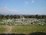
Apart from Teos, a major Ionian port and artistic and cult center, two other ancient settlements datable to the ancient Greek period and beyond are located along Seferihisar district's seashore, both to the south of Teos. Near the southern boundary of the district is Lebedos, the smallest of the twelve original Ionian settlements along the Anatolian coastline. PausaniasPausanias (geographer)
Pausanias was a Greek traveler and geographer of the 2nd century AD, who lived in the times of Hadrian, Antoninus Pius and Marcus Aurelius. He is famous for his Description of Greece , a lengthy work that describes ancient Greece from firsthand observations, and is a crucial link between classical...
mentions that the town was initially inhabited by Carians, for whom the region is normally a very northern one, and that Ionian Greeks immigrated there under the guidance of Andræmon, while Strabo
Strabo
Strabo, also written Strabon was a Greek historian, geographer and philosopher.-Life:Strabo was born to an affluent family from Amaseia in Pontus , a city which he said was situated the approximate equivalent of 75 km from the Black Sea...
gives the name the colonizing leader as Andropompus and that it previously bore the name of Artis of ancient Lydia
Lydia
Lydia was an Iron Age kingdom of western Asia Minor located generally east of ancient Ionia in the modern Turkish provinces of Manisa and inland İzmir. Its population spoke an Anatolian language known as Lydian....
. Although it is known to have engaged in maritime commerce, was famous for its mineral springs and a member of the Ionian League
Ionian League
The Ionian League , also called the Panionic League, was a confederation formed at the end of the Meliac War in the mid-7th century BC comprising twelve Ionian cities .These were listed by Herodotus as*Miletus, Myus, and...
, the peninsular settlement of Lebedos suffered from the limited space of its hinterland and a comparatively unsuitable port. It has not been excavated and the visible ruins are scanty.
The other settlement, at the edge of a promontory between Teos and Lebedos, referred to by Hecataeus of Miletus (500 BC) as a "city" and by Artemidorus of Ephesus (100 BC) as merely a "place" is Myonnesos. The best definition for ancient times must have corresponded to that of a small town, advantaged by a peninsula with a 60 m cliff which was very difficult to access and easy to defend. Traces of Cyclopeian walls attest to the presence of a very particular site and it remains a visitor's attraction due to the challenges of rock climbing
Rock climbing
Rock climbing also lightly called 'The Gravity Game', is a sport in which participants climb up, down or across natural rock formations or artificial rock walls. The goal is to reach the summit of a formation or the endpoint of a pre-defined route without falling...
it offers.
Ottoman records refer to the present-day center town alternatively as "Seferihisar" or "Sivrihisar", sometimes leading to confusion with another town in Central Anatolia still named Sivrihisar
Sivrihisar
Sivrihisar is a town and district of Eskişehir Province in the Central Anatolia region of Turkey. According to 2010 census, population of the district is 23 488 of which 9,817 live in the town of Sivrihisar...
, and which itself was nevertheless recorded from time to time as "Seferihisar". While the historic medrese in the depending village of Hereke (Düzce today) remained a regional center of learning throughout, on many occasions during the Ottoman period, the region of Seferihisar had made itself notorious as a pirate's lair, being a particularly appreciated hideout and at times a practically autonomous entity. The town is notably the birthplace of two of the best known Turkish corsairs of the very end of the 15th century, Kara Hasan and Kara Turmuş
The region was, as such, scarcely populated and development came gradually only in the course of the 19th century, due especially to cultivation of citrus fruits and cash crops. The municipal administration was instituted in 1884 and by the time of the fall of the Empire, the kaza of Seferihisar counted roughly twenty thousand people, in which about half or slightly less, according to varying sources, were Greeks, mostly recent immigrants from the islands.
Sights of interest
The district's most popular sights of interest is its depending small port of Sığacık with the GenoeseRepublic of Genoa
The Most Serene Republic of Genoa |Ligurian]]: Repúbrica de Zêna) was an independent state from 1005 to 1797 in Liguria on the northwestern Italian coast, as well as Corsica from 1347 to 1768, and numerous other territories throughout the Mediterranean....
- Ottomans
Ottoman Empire
The Ottoman EmpireIt was usually referred to as the "Ottoman Empire", the "Turkish Empire", the "Ottoman Caliphate" or more commonly "Turkey" by its contemporaries...
. The ancient city of Teos
Teos
Teos or Teo was a maritime city of Ionia, on a peninsula between Chytrium and Myonnesus, colonized by Orchomenian Minyans, Ionians, and Boeotians. The city is situated on a low hilly narrow strip of land connecting two larger areas of land . Teos ranked among twelve cities comprising the Ionian...
is located between Seferihisar and Sığacık.
There is also the rock of Myonnesos and the ruins locally called "Karaköse", both near Doğanbey township. The other ancient city found within the district, Lebedos, is located further south, near Ürkmez
Ürkmez
Ürkmez is a small coastal town with own municipality and administratively depending the district center of Seferihisar in İzmir Province, Turkey.It is also a holiday resort, situated at a distance of approximately from the province center of Izmir...
township.
A French
France
The French Republic , The French Republic , The French Republic , (commonly known as France , is a unitary semi-presidential republic in Western Europe with several overseas territories and islands located on other continents and in the Indian, Pacific, and Atlantic oceans. Metropolitan France...
vacation village is located near Sığacık. Seferihisar district also has beautiful beaches and bays along its 27 km.-long coast.
Recent news
There are four small dams built for irrigation purposes within the boundaries of Seferihisar district and effort is being pursued to use the region's geothermal energy resources.On 8 December 2007, the sea route from Seferihisar to Chios
Chios
Chios is the fifth largest of the Greek islands, situated in the Aegean Sea, seven kilometres off the Asia Minor coast. The island is separated from Turkey by the Chios Strait. The island is noted for its strong merchant shipping community, its unique mastic gum and its medieval villages...
was the scene of the single largest maritime incident in terms of loss of lives and involving migrants in the Aegean Sea
Aegean Sea
The Aegean Sea[p] is an elongated embayment of the Mediterranean Sea located between the southern Balkan and Anatolian peninsulas, i.e., between the mainlands of Greece and Turkey. In the north, it is connected to the Marmara Sea and Black Sea by the Dardanelles and Bosporus...
with the tragic occurrence of December 2007 Seferihisar, Turkey migrant boat disaster
December 2007 Seferihisar, Turkey migrant boat disaster
The December 2007 Seferihisar, Turkey migrant boat disaster occurred in the night of 8 December 2007 when a 15-meter dinghy boat carrying illegal migrants who were trying to reach the island of Chios, Greece, capsized due to bad sea conditions off the coast of Seferihisar, İzmir Province, western...
.
In December 2009, Seferihisar became the first Turkish town named a member of the Cittaslow
Cittaslow
Cittaslow is a movement founded in Italy in October 1999. The inspiration of Cittaslow was the Slow Food organization. Cittaslow's goals include improving the quality of life in towns by slowing down its overall pace, especially in a city's use of spaces and the flow of life and traffic through them...
movement. As the newest member of the movement, Seferihisar will host a football tournament between several Cittaslow cities which will be held in June 2010. .