

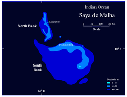
Saya de Malha Bank
Encyclopedia
Bank (topography)
A bank, sometimes referred to as a fishing bank, is an area on the continental shelf which is shallow compared to its surrounding area, such as a shoal or the top of an underwater hill. Somewhat like continental slopes, ocean banks slopes can upwell as tidal and other flows intercept them,...
in the World
World
World is a common name for the whole of human civilization, specifically human experience, history, or the human condition in general, worldwide, i.e. anywhere on Earth....
, part of the vast undersea Mascarene Plateau
Mascarene Plateau
The Mascarene Plateau is an submarine plateau in the Indian Ocean, north and east of Madagascar. The plateau extends approximately 2000 km, from the Seychelles in the north to Réunion in the south. The plateau covers an area of over 115,000 km² of shallow water, with depths ranging from...
. It lies east of Madagascar
Madagascar
The Republic of Madagascar is an island country located in the Indian Ocean off the southeastern coast of Africa...
, southeast of the Seychelles
Seychelles
Seychelles , officially the Republic of Seychelles , is an island country spanning an archipelago of 115 islands in the Indian Ocean, some east of mainland Africa, northeast of the island of Madagascar....
, and north of the Nazareth Bank
Nazareth Bank
Nazareth Bank is a large submerged bank in the Indian Ocean. It lies about 1040 km east of northern Madagascar and 280 km south of Saya de Malha Bank. The closest land is Cargados Carajos shoals, a small and remote dependency of Mauritius located 140 km to the southwest. The Nazareth...
, the Cargados Carajos
Cargados Carajos
Cargados Carajos Shoals are a group of about 16 small islands and islets on an extended reef in the Indian Ocean northeast of Mauritius. The islands have a total land area of 1.3 km². The reef measures more than 50 km from north to south, and is 5 km wide, cut by three passes. The...
shoals, and the island of Mauritius
Mauritius
Mauritius , officially the Republic of Mauritius is an island nation off the southeast coast of the African continent in the southwest Indian Ocean, about east of Madagascar...
, and falls into the Mauritian exclusive economic zone. The closest land is the tiny Agalega Islands
Agalega Islands
The Agalega Islands are two islands in the Indian Ocean, lying north of Mauritius at and are governed by that country. The islands have a total area of 24 km² , although the official figure of 70 km² appears too high when compared with data from satellite images.The North Island is home...
(a remote dependency of Mauritius
Mauritius
Mauritius , officially the Republic of Mauritius is an island nation off the southeast coast of the African continent in the southwest Indian Ocean, about east of Madagascar...
), some 300 km (186.4 mi) further west, followed by the southern Seychellois
Seychelles
Seychelles , officially the Republic of Seychelles , is an island country spanning an archipelago of 115 islands in the Indian Ocean, some east of mainland Africa, northeast of the island of Madagascar....
island of Coëtivy
Coëtivy Island
Coëtivy Island is a small coral island in the Seychelles 290 km south of Mahe, at . Along with Île Platte, the nearest neighbor 171 km northwest, it comprises the Southern Coral Group and therefore belongs to the Outer Islands . Its area is 9.31 km² and it has a population of 252. It was named...
, some 400 km (248.5 mi) northwest. Mauritius
Mauritius
Mauritius , officially the Republic of Mauritius is an island nation off the southeast coast of the African continent in the southwest Indian Ocean, about east of Madagascar...
administers the whole Saya de Malha Bank as part of its Exclusive Economic Zone
Exclusive Economic Zone
Under the law of the sea, an exclusive economic zone is a seazone over which a state has special rights over the exploration and use of marine resources, including production of energy from water and wind. It stretches from the seaward edge of the state's territorial sea out to 200 nautical...
, despite the fact that only a small portion of it lies within its Exclusive Economic Zone.
The bank covers an area of 40808 km² (15,756 sq mi), and is composed of two separate structures, the smaller North Bank (also called Ritchie Bank), and the huge South Bank. If the South Bank were recognized as a submerged atoll
Atoll
An atoll is a coral island that encircles a lagoon partially or completely.- Usage :The word atoll comes from the Dhivehi word atholhu OED...
structure, it would be the largest of the world, almost three times the size of the Great Chagos Bank
Great Chagos Bank
The Great Chagos Bank, in the Chagos Archipelago, about South of the Maldives, is the largest atoll structure in the world, with a total area of . The Atoll is administered by the UK through the BIOT.-Islands:...
, commonly considered the largest atoll structure of the world. Even smaller North Bank would be one of the largest atolls worldwide. The North Bank and the South Bank appear to have different origins, since they are separated by a fault
Geologic fault
In geology, a fault is a planar fracture or discontinuity in a volume of rock, across which there has been significant displacement along the fractures as a result of earth movement. Large faults within the Earth's crust result from the action of tectonic forces...
. Studies show that the South Bank and the Great Chagos Bank
Great Chagos Bank
The Great Chagos Bank, in the Chagos Archipelago, about South of the Maldives, is the largest atoll structure in the world, with a total area of . The Atoll is administered by the UK through the BIOT.-Islands:...
were one single feature until about 64 to 69 million years ago, when an ocean ridge opened between them and started pushing them apart.
Saya de Malha Bank consists of a series of narrow shoals, with depths from 17 to 29 m (55.8 to 95.1 ft) on the rim. They are arranged in a semicircular manner, around a space, the former lagoon
Lagoon
A lagoon is a body of shallow sea water or brackish water separated from the sea by some form of barrier. The EU's habitat directive defines lagoons as "expanses of shallow coastal salt water, of varying salinity or water volume, wholly or partially separated from the sea by sand banks or shingle,...
, about 73 m (239.5 ft) deep, which slopes on the Southeast. Some areas of the bank are shallow, less than 10 m (32.8 ft) below the surface. The shallowest sites known are Poydenot Rock, at a depth of 8 m (26.2 ft), and an unnamed site 145 km (90.1 mi) further northwest, with a depth of 7 m (23 ft). The banks are covered with sea grass interspersed with small coral reef
Coral reef
Coral reefs are underwater structures made from calcium carbonate secreted by corals. Coral reefs are colonies of tiny living animals found in marine waters that contain few nutrients. Most coral reefs are built from stony corals, which in turn consist of polyps that cluster in groups. The polyps...
s. Due to its remote location, the bank is among the least-studied shallow marine ecoregions on the planet. The banks are a breeding ground for Humpback Whale
Humpback Whale
The humpback whale is a species of baleen whale. One of the larger rorqual species, adults range in length from and weigh approximately . The humpback has a distinctive body shape, with unusually long pectoral fins and a knobbly head. It is an acrobatic animal, often breaching and slapping the...
s and Blue Whale
Blue Whale
The blue whale is a marine mammal belonging to the suborder of baleen whales . At in length and or more in weight, it is the largest known animal to have ever existed....
s.
History
The bank was named by PortuguesePortugal
Portugal , officially the Portuguese Republic is a country situated in southwestern Europe on the Iberian Peninsula. Portugal is the westernmost country of Europe, and is bordered by the Atlantic Ocean to the West and South and by Spain to the North and East. The Atlantic archipelagos of the...
explorers 500 years ago, who encountered the bank on the voyage between the Cape of Good Hope
Cape of Good Hope
The Cape of Good Hope is a rocky headland on the Atlantic coast of the Cape Peninsula, South Africa.There is a misconception that the Cape of Good Hope is the southern tip of Africa, because it was once believed to be the dividing point between the Atlantic and Indian Oceans. In fact, the...
and India
India
India , officially the Republic of India , is a country in South Asia. It is the seventh-largest country by geographical area, the second-most populous country with over 1.2 billion people, and the most populous democracy in the world...
. After traversing miles of deep blue Indian Ocean, they found themselves sailing above a shallow area of the bank, covered with swaying green seagrass.
The first serious survey of the bank was undertaken by Captain Robert Moresby
Robert Moresby
Robert Moresby was a distinguished captain of the British Royal Navy. He was also an excellent hydrographer, maritime surveyor and draughtsman....
of the Royal Navy in 1838. Moresby previously surveyed the Laccadives
Lakshadweep
Lakshadweep , formerly known as the Laccadive, Minicoy, and Amindivi Islands, is a group of islands in the Laccadive Sea, 200 to 440 km off the coast of the South West Indian state of Kerala...
, the Red Sea
Red Sea
The Red Sea is a seawater inlet of the Indian Ocean, lying between Africa and Asia. The connection to the ocean is in the south through the Bab el Mandeb strait and the Gulf of Aden. In the north, there is the Sinai Peninsula, the Gulf of Aqaba, and the Gulf of Suez...
, the Maldives
Maldives
The Maldives , , officially Republic of Maldives , also referred to as the Maldive Islands, is an island nation in the Indian Ocean formed by a double chain of twenty-six atolls oriented north-south off India's Lakshadweep islands, between Minicoy Island and...
and the Chagos Banks. Due to Moresby's ill health, the Saya de Malha bank was his last survey in a long and brilliant career exploring and charting the archipelagos and reefs of the Indian Ocean.
Geology
The bank was formed 35 million years ago by the Réunion hotspotRéunion hotspot
The Réunion hotspot is a volcanic hotspot which currently lies under the Island of Réunion in the Indian Ocean. The Chagos-Laccadive Ridge and the southern part of the Mascarene Plateau are volcanic traces of the Réunion hotspot....
, and is composed of basalt
Basalt
Basalt is a common extrusive volcanic rock. It is usually grey to black and fine-grained due to rapid cooling of lava at the surface of a planet. It may be porphyritic containing larger crystals in a fine matrix, or vesicular, or frothy scoria. Unweathered basalt is black or grey...
ic basal rock overlain with limestone
Limestone
Limestone is a sedimentary rock composed largely of the minerals calcite and aragonite, which are different crystal forms of calcium carbonate . Many limestones are composed from skeletal fragments of marine organisms such as coral or foraminifera....
. The limestone banks found on the plateau are the remnants of coral reefs. Millions of years ago, the bank was one or more mountainous volcanic islands, like present-day Mauritius
Mauritius
Mauritius , officially the Republic of Mauritius is an island nation off the southeast coast of the African continent in the southwest Indian Ocean, about east of Madagascar...
and Réunion
Réunion
Réunion is a French island with a population of about 800,000 located in the Indian Ocean, east of Madagascar, about south west of Mauritius, the nearest island.Administratively, Réunion is one of the overseas departments of France...
, which subsequently sank below the waves. Some of the banks may have been low islands as recently as 18,000 - 6,000 years ago, when sea levels were up to 130 m (426.5 ft) lower during the most recent ice age.
Artificial island project
The Saya de Malha Bank is, or was, the site of an attempt to create an artificial islandArtificial island
An artificial island or man-made island is an island or archipelago that has been constructed by people rather than formed by natural means...
by Wolf Hilbertz
Wolf Hilbertz
Prof. Wolf Hartmut Hilbertz was a German-born futurist architect, inventor, and marine scientist.-Youth and schooling:...
(1938-2007) and Dr. Thomas Goreau. Hilbertz created seacrete and biorock by combining the minerals in sea brine with electricity to create an artificial coral or building materials. Hilbertz and Goreau made several expeditions to the bank to attempt to create or grow an island around a steel structure that has been anchored to the North Bank sea floor at a depth of 11 m (36.1 ft). Some sources say that the island would have been named Autopia or Autopia Saya, and declared a micronation
Micronation
Micronations, sometimes also referred to as model countries and new country projects, are entities that claim to be independent nations or states but which are not recognized by world governments or major international organizations...
.
Excerpt from an online interview with Wolf Hilbertz in Celestopea Times, 2004
- You and your discovery of accreting minerals in seawater into solid forms has inspired several groups over the years to contemplate creating artificial islands for their piece of paradise. Your name has been linked to some such as Autopia Ampere and Skerki Bank. Is there an update on either of those projects or words of encouragement for others seeking something similar?
- Examining the geography and bathymetry of the globe to find a spot in the ocean where to establish a permanent research settlement I came upon Seamount Ampere, east of Gibraltar, and Skerki Bank near Sicily. Both sites had potential, but Saya de Malha Banks in the NE Indian Ocean eclipsed them all. Having about the size of Belgium, most of Saya lies in international waters, 'in the high seas' legally speaking, governed only by the U.N. Law of the Sea. In 1997, Goreau and I sailed to Saya de Malha's many shallow sites and established the first accretion structure there, powered by floating photovoltaics and thus claiming the banks. In 2002 the second Saya de Malha Expedition with three boats laid the foundation of Autopia Saya, powered by photovoltaics, and performed the first modern bathymetric surveys ever conducted in the area. The latest Saya de Malha Expedition Report is on our websites. We are busy now organizing a third expedition to get Autopia Saya growing above sea level.
Mauritius
Mauritius
Mauritius , officially the Republic of Mauritius is an island nation off the southeast coast of the African continent in the southwest Indian Ocean, about east of Madagascar...
claims the Saya de Malha Bank as part of its Exclusive Economic Zone. In the similar situation, Tonga
Tonga
Tonga, officially the Kingdom of Tonga , is a state and an archipelago in the South Pacific Ocean, comprising 176 islands scattered over of ocean in the South Pacific...
evicted the Republic of Minerva
Republic of Minerva
The Republic of Minerva was one of the few modern attempts at creating a sovereign micronation on the reclaimed land of an artificial island in 1972. The architect was Las Vegas real estate millionaire and political activist Michael Oliver, who went on to other similar attempts in the following...
from the Minerva Reefs
Minerva Reefs
The Minerva Reefs are a group of two submerged atolls located in the Pacific Ocean south of Fiji and Tonga. The reefs were named after the whaleship Minerva, was wrecked on what became known as South Minerva after setting out from Sydney in 1829...
by arguing that they had established a claim over that non-adjoining underwater site by traditional fishing use.