
Sarandib Planitia
Encyclopedia
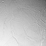
Sarandib Planitia is a region of relatively un-cratered terrain on Saturn
's moon Enceladus
. It is located at 4.4° North Latitude
, 298.0° West Longitude
and is approximately 200 km across. From Voyager images, Sarandib Planitia is considered part of either the ridged plains unit (Kargel and Pozio 1996) or smooth plains unit (Rothery 1999) of Enceladus, thought to be the youngest terrain on Enceladus. In more recent (and higher resolution) Cassini images, Sarandib is resolved into a region of relatively low ridges, with a band of rifted terrain cutting through the middle from northwest to southeast. In addition, a series of long-wavelength compression ridges are seen in the western portion of Sarandib Planitia, reminiscent of banded terrain on Europa
, like Astypalaea Linea. Only ~20 craters
larger than 1 kilometer across (the largest only 4.5 kilometers across) have been found in Sarandib, demonstrating the youthful age of the region.
Sarandib Planitia is bounded on the north and west by a band of grooved terrain named Samarkand Sulci
. Given the similarity in the spatial relationship between the Diyar Planitia
and Harran Sulci
, it is likely that the formation of Sarandib Plantia and Samarkand Sulci are related.
Sarandib Planitia is named from the old Arabic/Persian
/Urdu name for Sri Lanka
, an island visited by Sindbad on his 6th voyage in Arabian Nights.
Saturn
Saturn is the sixth planet from the Sun and the second largest planet in the Solar System, after Jupiter. Saturn is named after the Roman god Saturn, equated to the Greek Cronus , the Babylonian Ninurta and the Hindu Shani. Saturn's astronomical symbol represents the Roman god's sickle.Saturn,...
's moon Enceladus
Enceladus (moon)
Enceladus is the sixth-largest of the moons of Saturn. It was discovered in 1789 by William Herschel. Until the two Voyager spacecraft passed near it in the early 1980s very little was known about this small moon besides the identification of water ice on its surface...
. It is located at 4.4° North Latitude
Latitude
In geography, the latitude of a location on the Earth is the angular distance of that location south or north of the Equator. The latitude is an angle, and is usually measured in degrees . The equator has a latitude of 0°, the North pole has a latitude of 90° north , and the South pole has a...
, 298.0° West Longitude
Longitude
Longitude is a geographic coordinate that specifies the east-west position of a point on the Earth's surface. It is an angular measurement, usually expressed in degrees, minutes and seconds, and denoted by the Greek letter lambda ....
and is approximately 200 km across. From Voyager images, Sarandib Planitia is considered part of either the ridged plains unit (Kargel and Pozio 1996) or smooth plains unit (Rothery 1999) of Enceladus, thought to be the youngest terrain on Enceladus. In more recent (and higher resolution) Cassini images, Sarandib is resolved into a region of relatively low ridges, with a band of rifted terrain cutting through the middle from northwest to southeast. In addition, a series of long-wavelength compression ridges are seen in the western portion of Sarandib Planitia, reminiscent of banded terrain on Europa
Europa (moon)
Europa Slightly smaller than Earth's Moon, Europa is primarily made of silicate rock and probably has an iron core. It has a tenuous atmosphere composed primarily of oxygen. Its surface is composed of ice and is one of the smoothest in the Solar System. This surface is striated by cracks and...
, like Astypalaea Linea. Only ~20 craters
Impact crater
In the broadest sense, the term impact crater can be applied to any depression, natural or manmade, resulting from the high velocity impact of a projectile with a larger body...
larger than 1 kilometer across (the largest only 4.5 kilometers across) have been found in Sarandib, demonstrating the youthful age of the region.
Sarandib Planitia is bounded on the north and west by a band of grooved terrain named Samarkand Sulci
Samarkand Sulci
Samarkand Sulci is a region of grooved terrain on the surface of Saturn's moon Enceladus. The feature is centered at 30.5° North Latitude, 326.8° West Longitude and is approximately 383 kilometers long. Samarkand Sulci consists of three parts. The southern and eastern extensions bound Sarandib...
. Given the similarity in the spatial relationship between the Diyar Planitia
Diyar Planitia
Diyar Planitia is a region of relatively un-cratered terrain on Saturn's moon Enceladus. It is located at 0.5° North Latitude, 239.7° West Longitude and is approximately 311 km across....
and Harran Sulci
Harran Sulci
Harran Sulci is a region of grooved terrain on the surface of Saturn's moon Enceladus. The feature is centered at 26.7° North Latitude, 237.6° West Longitude and is approximately 276 kilometers long...
, it is likely that the formation of Sarandib Plantia and Samarkand Sulci are related.
Sarandib Planitia is named from the old Arabic/Persian
Persian language
Persian is an Iranian language within the Indo-Iranian branch of the Indo-European languages. It is primarily spoken in Iran, Afghanistan, Tajikistan and countries which historically came under Persian influence...
/Urdu name for Sri Lanka
Sri Lanka
Sri Lanka, officially the Democratic Socialist Republic of Sri Lanka is a country off the southern coast of the Indian subcontinent. Known until 1972 as Ceylon , Sri Lanka is an island surrounded by the Indian Ocean, the Gulf of Mannar and the Palk Strait, and lies in the vicinity of India and the...
, an island visited by Sindbad on his 6th voyage in Arabian Nights.