
Santiago Metro
Encyclopedia
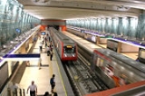
Metro de Santiago is South America's most extensive metro system with 5 lines, 108 stations and 103 kilometres of track making it the second longest in Latin America after that of Mexico City. The metro
system serves the city of Santiago
, Chile
. Three of the lines are rubber-tyred metro
. 4-Line and 4A-Line are traditional steel wheels. The system services around 2,300,000 passengers per day.
The system is administered by the state-owned Metro S.A.. Along with Metro Valparaíso
in the city of Valparaíso
and the Biotren
in Concepción, it is one of the three metropolitan railway systems in Chile
.
's most important construction projects. While lines 1, 2, and 5 use rubber tire stock, lines 4 and 4A use steel wheels in order to increase capacity.
The rapid growth of the population in the city (in 1920, 507,296 inhabitants; in 1940, 1,073,699 inhabitants) was the principal factor in the birth of the idea. The first plan was in 1944, but only in 1968 did work begin. The original plan was for 5 lines:
The city had changed since 1968 and the plan had to be changed too. La Florida had become the most populous zone of the city, and the Metro needed to go there. Line 5 was built south from Baquedano along Vicuña Mackenna Avenue and was opened in 1997. Line 5 was extended in 2000 to the west and entered the historical centre of the city (Plaza de Armas station), and in 2004 the extensions of Line 2 to the north and south and Line 5 to the west were opened.
In 2002 the construction of Line 4 and Line 4A began, in order to connect Puente Alto and the southeast of the City to the metro system.
Near the end of 2005, President Ricardo Lagos
said that the government will start to plan the construction of another extension of line 5. It would reach Maipú, one of the municipalities that is further away from the centre of Santiago
.
At the end of 2009, former President Michelle Bachelet
announced the construction of Line 6. The new line will connect eight communities with 12 stations over 14.8 kilometres. In October 2010, President Sebastián Piñera
announced that Line 3 is in planning. Both lines are projected to be in operation by 2014.
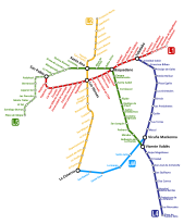 Nowadays, Metro consists of five lines which total 84 kilometres and a total of 82 stations and seven transfer stations: Los Héroes, Baquedano, Santa Ana, Tobalaba, Vicente Valdés, Vicuña Mackenna and La Cisterna. Seven new stations are opened on February 3, 2011.
and MP 89
stock of the Paris Metro
respectively. http://es.wikipedia.org/wiki/Metro_de_Santiago
azulejo
s, a gift made by the Lisbon Metro
), La Moneda (with realistic painting representing typical landscape), and various other stations.
, the integrated public transport system that serves the capital using also feeder and main bus routes. Transantiago works with an integrated fare system, which allows passengers to make bus-bus or bus-metro transfers on a two-hour time limit for the price of one ticket, using a contactless smart card
called "Bip! card". These cards are available in all the ticketing offices in every station at a cost of $
2.000 (approx. US$
4.00), including $700 worth of credit. Tickets are sold from 6:00 to 23:00 Monday to Friday, 6:30 to 23:00 on Saturdays, and 8:00 to 22:30 on Sundays and holidays. Cards can be topped up to $20.000, and the credit only expires if the card it is not used in two years.
Metro de Santiago also sells single-trip tickets. These don't allow transfers to buses. Fares depend on the time of the use of the system. The cost of a ticket in the Horario Punta (rush hour
, 7:00-8:59 and 18:00-19:59) is $
620 (approx. US$
1.25); in the Horario Valle (off-peak hours, 6:30-6:59, 9:00-17:59, 20:00-20:44, and all day on weekends and holidays) is $570 (approximately US$1.15); and in the Horario Bajo (low-use hours, 6:00-6:29 and 20:45-23:00) is $520 (approximately US$1.05). Senior citizens (65 and older) and students holding concession cards pay $180 (US $0.35). Senior concession fare does not apply during rush hours.
No motive has been established, though it is suspected that Huerta was affected by his mother's death several months before.
Rapid transit
A rapid transit, underground, subway, elevated railway, metro or metropolitan railway system is an electric passenger railway in an urban area with a high capacity and frequency, and grade separation from other traffic. Rapid transit systems are typically located either in underground tunnels or on...
system serves the city of Santiago
Santiago, Chile
Santiago , also known as Santiago de Chile, is the capital and largest city of Chile, and the center of its largest conurbation . It is located in the country's central valley, at an elevation of above mean sea level...
, Chile
Chile
Chile ,officially the Republic of Chile , is a country in South America occupying a long, narrow coastal strip between the Andes mountains to the east and the Pacific Ocean to the west. It borders Peru to the north, Bolivia to the northeast, Argentina to the east, and the Drake Passage in the far...
. Three of the lines are rubber-tyred metro
Rubber-tyred metro
A rubber-tyred metro is a form of rapid transit system that uses a mix of road and rail technology. The vehicles have wheels with rubber tyres which run on rolling pads inside guide bars for traction, as well as traditional railway steel wheels with deep flanges on steel tracks for guidance through...
. 4-Line and 4A-Line are traditional steel wheels. The system services around 2,300,000 passengers per day.
The system is administered by the state-owned Metro S.A.. Along with Metro Valparaíso
Valparaíso Metro
Metro Valparaíso is the metro system serving the urban conglomeration of Gran Valparaíso, Chile , connecting the cities of Valparaíso, Viña del Mar, Quilpué, Villa Alemana and Limache, this last one, outside of the conurbation...
in the city of Valparaíso
Valparaíso
Valparaíso is a city and commune of Chile, center of its third largest conurbation and one of the country's most important seaports and an increasing cultural center in the Southwest Pacific hemisphere. The city is the capital of the Valparaíso Province and the Valparaíso Region...
and the Biotren
Biotren
The similar system for Metro of Concepción or Biotren is basic at grade urban commuter rail system that covers a big part of the city of Concepción, capital of the region of Bío-Bío, also known as Gran Concepción or Concepción Metropolitan Area, both synonyms of "city" according to the urbanistic...
in Concepción, it is one of the three metropolitan railway systems in Chile
Chile
Chile ,officially the Republic of Chile , is a country in South America occupying a long, narrow coastal strip between the Andes mountains to the east and the Pacific Ocean to the west. It borders Peru to the north, Bolivia to the northeast, Argentina to the east, and the Drake Passage in the far...
.
History
Origin and first project
It serves a city of 6 million inhabitants. Since its opening in 1975, el Metro has changed the city; it is one of ChileChile
Chile ,officially the Republic of Chile , is a country in South America occupying a long, narrow coastal strip between the Andes mountains to the east and the Pacific Ocean to the west. It borders Peru to the north, Bolivia to the northeast, Argentina to the east, and the Drake Passage in the far...
's most important construction projects. While lines 1, 2, and 5 use rubber tire stock, lines 4 and 4A use steel wheels in order to increase capacity.
The rapid growth of the population in the city (in 1920, 507,296 inhabitants; in 1940, 1,073,699 inhabitants) was the principal factor in the birth of the idea. The first plan was in 1944, but only in 1968 did work begin. The original plan was for 5 lines:
- Line 1, between San Pablo and Los Dominicos by the Alameda, Providencia and Apoquindo Avenues.
- Line 2, between Conchalí and San Miguel by Vivaceta, Panamerican Highway and Gran Avenida.
- Line 3, (planned, no construction date set) between Mapocho and Ñuñoa, by Ahumada and the avenues Matta and Irarrázaval.
- Line 4, between Tobalaba (Providencia) and Puente Alto, to the South
- Line 5, between Maipú and La Florida.
Extension
On September 15, 1975, Augusto Pinochet opened the first section of the underground railway between San Pablo and La Moneda on Line 1. Line 2 was opened in 1978 between Los Héroes and Lo Ovalle, and Line 1 was extended to Escuela Militar in 1980. Line 2 was extended to the north and found the remains of the Cal y Canto Bridge (built in 1782 and destroyed in 1880). The extension between Los Héroes and Puente Cal y Canto (former Mapocho Station) was inaugurated in 1987.The city had changed since 1968 and the plan had to be changed too. La Florida had become the most populous zone of the city, and the Metro needed to go there. Line 5 was built south from Baquedano along Vicuña Mackenna Avenue and was opened in 1997. Line 5 was extended in 2000 to the west and entered the historical centre of the city (Plaza de Armas station), and in 2004 the extensions of Line 2 to the north and south and Line 5 to the west were opened.
In 2002 the construction of Line 4 and Line 4A began, in order to connect Puente Alto and the southeast of the City to the metro system.
Near the end of 2005, President Ricardo Lagos
Ricardo Lagos
Ricardo Froilán Lagos Escobar is a lawyer, economist and social democrat politician, who served as president of Chile from 2000 to 2006. He won the 1999-2000 presidential election by a narrow margin in a runoff over Independent Democrat Union candidate Joaquín Lavín...
said that the government will start to plan the construction of another extension of line 5. It would reach Maipú, one of the municipalities that is further away from the centre of Santiago
Santiago, Chile
Santiago , also known as Santiago de Chile, is the capital and largest city of Chile, and the center of its largest conurbation . It is located in the country's central valley, at an elevation of above mean sea level...
.
At the end of 2009, former President Michelle Bachelet
Michelle Bachelet
Verónica Michelle Bachelet Jeria is a Social Democrat politician who was President of Chile from 11 March 2006 to 11 March 2010. She was the first woman president of her country...
announced the construction of Line 6. The new line will connect eight communities with 12 stations over 14.8 kilometres. In October 2010, President Sebastián Piñera
Sebastián Piñera
Miguel Juan Sebastián Piñera Echenique is a Chilean businessman and politician. He was elected President of Chile in January 2010, taking office in March 2010.- Education :...
announced that Line 3 is in planning. Both lines are projected to be in operation by 2014.
| Line | Length | Stations | Opening Date | Type | |
|---|---|---|---|---|---|
 |
San Pablo - La Moneda | 8,2 km | 12 | 15 Sept, 1975 | Underground |
|
La Moneda- Salvador | 3,2 km | 5 | 31 Mar, 1977 | Underground |
| Los Héroes - Franklin | 4,9 km | 4 | 31 Mar, 1978 | Ground Level | |
| Franklin - Lo Ovalle | 4.8 km | 6 | 21 Dec, 1978 | Underground | |
|
Salvador - Escuela Militar | 4,5 km | 6 | 22 Aug, 1980 | Underground |
| Los Héroes - Puente Cal y Canto | 1,7 km | 2 | 15 Sept, 1987 | Ground level | |
| Baquedano - Bellavista de La Florida | 10,3 km | 11 | 5 Apr, 1997 | Viaduct | |
| Baquedano - Santa Ana | 2,7 km | 2 | 4 Mar, 2000 | Underground | |
| Santa Ana - Quinta Normal | 1,9 km | 2 | 31 Mar, 2004 | Underground | |
| Puente Cal y Canto - Cerro Blanco | 1,6 km | 2 | 8 Sept, 2004 | Underground | |
| Lo Ovalle - La Cisterna | 2,1 km | 2 | 22 Dec, 2004 | Underground | |
| Cerro Blanco - Einstein | 1,9 km | 2 | 25 Nov, 2005 | Underground | |
| Bellavista de La Florida- Vicente Valdés | 0,6 km | 1 | 30 Nov, 2005 | Underground | |
| Vicente Valdés - Plaza de Puente Alto | 10,9 km | 9 | 30 Nov, 2005 | Viaduct | |
| Tobalaba - Grecia | 7,7 km | 7 | 30 Nov, 2005 | Underground | |
| Grecia - Vicente Valdés | 6,1 km | 5 | 2 Mar, 2006 | Ground level | |
| Vicuña Mackenna - La Cisterna | 7,7 km | 6 | 16 Aug, 2006 | Ground level | |
| Einstein - Vespucio Norte | 3,6 km | 3 | 21 Dec, 2006 | Underground | |
| San José de la Estrella | 0 km | 1 | 5 Nov, 2009 | Viaduct | |
|
Escuela Militar - Los Dominicos | 4 km | 3 | 7 Jan, 2010 | Underground |
| Quinta Normal - Pudahuel | 5,8 km | 5 | 12 Jan, 2010 | Underground | |
| Pudahuel - Plaza de Maipú | 8 km | 7 | 3 Feb, 2011 | Viaduct | |
| Pedro Aguirre Cerda - Los Leones | 14,8 km | 10 | 2016 | Underground | |
| Huechuraba - Larraín | 21 km | 18 | 2017 | Underground |
Rolling Stocks
The Santiago Metro currently operate 6 models of rolling stock, one model (the AS 02) is steel-wheeled, while the others are all rubber-tyred. The NS 74 and NS 93 stock are based off the MP 73MP 73
The MP 73 is a rubber tired variant of electric multiple units used on Paris's Métro system. The cars were delivered in 1974, when the RATP decided to convert Line 6 to rubber tyred pneumatic operation...
and MP 89
MP 89
The MP 89 is a rubber tired variant of electric multiple units used on Paris's Métro system. Designed by Roger Tallon, two types are built by GEC Alsthom for service on Line 1, 4, and 14.-History:...
stock of the Paris Metro
Paris Métro
The Paris Métro or Métropolitain is the rapid transit metro system in Paris, France. It has become a symbol of the city, noted for its density within the city limits and its uniform architecture influenced by Art Nouveau. The network's sixteen lines are mostly underground and run to 214 km ...
respectively. http://es.wikipedia.org/wiki/Metro_de_Santiago
| Model | Manufacturer | Year Built !! Operating Lines | |
|---|---|---|---|
| NS 73 | Alstom | 1973 - 1981 | Lines 2 & 5 |
| NS 88 | Concarril | 1987 | Line 2 |
| NS 93 | Alstom | 1996 - 2003 | Lines 1, 2, & 5 |
| AS 02 | Alstom | 2004 - 2010 | Lines 4 & 4A |
| NS 04 | Alstom | 2006 - 2007 | Line 1 |
| NS 07 | CAF | 2009 - 2010 | Line 1 |
Stations
In bold are junction stations. In grey are stations currently under construction.Line 1 West to east |
Line 2 North to south |
Line 3 Northwest to east |
Line 4 Northeast to southeast |
Line 4A South to southeast |
Line 5 Southwest to southeast |
Line 6 Southwest to northeast |
|
|
|
|
|
|
|
Art in the Metro
Art is quite a present element in the stations. The station Universidad de Chile has a giant mural created by Mario Toral and represents the history of the country. Other pieces of art are in Baquedano (featuring modern art and a concert space), Bellas Artes (multimedia art), Santa Lucía (PortuguesePortugal
Portugal , officially the Portuguese Republic is a country situated in southwestern Europe on the Iberian Peninsula. Portugal is the westernmost country of Europe, and is bordered by the Atlantic Ocean to the West and South and by Spain to the North and East. The Atlantic archipelagos of the...
azulejo
Azulejo
Azulejo from the Arabic word Zellige زليج is a form of Portuguese or Spanish painted, tin-glazed, ceramic tilework. They have become a typical aspect of Portuguese culture, having been produced without interruption for five centuries...
s, a gift made by the Lisbon Metro
Lisbon Metro
The Lisbon Metro is the metro system of Lisbon, Portugal. Opened in December 1959, it was the first subway system in Portugal.As of 2011, the four Lisbon subway lines total about in length and comprise 52 stations.- History :- Idea :...
), La Moneda (with realistic painting representing typical landscape), and various other stations.
Pricing and working hours
Metro is part of TransantiagoTransantiago
Transantiago is a public transport system that serves Santiago, the capital of Chile. It is considered the most ambitious transport reform undertaken by a developing country according to the World Resources Institute....
, the integrated public transport system that serves the capital using also feeder and main bus routes. Transantiago works with an integrated fare system, which allows passengers to make bus-bus or bus-metro transfers on a two-hour time limit for the price of one ticket, using a contactless smart card
Contactless smart card
A contactless smart card is any pocket-sized card with embedded integrated circuits that can process and store data, and communicate with a terminal via radio waves. There are two broad categories of contactless smart cards. Memory cards contain non-volatile memory storage components, and perhaps...
called "Bip! card". These cards are available in all the ticketing offices in every station at a cost of $
Chilean peso
The peso is the currency of Chile. The current peso has circulated since 1975, with a previous version circulating between 1817 and 1960. The symbol used locally for it is $. The ISO 4217 code for the present peso is CLP. It is subdivided into 100 centavos, although no centavo denominated coins...
2.000 (approx. US$
United States dollar
The United States dollar , also referred to as the American dollar, is the official currency of the United States of America. It is divided into 100 smaller units called cents or pennies....
4.00), including $700 worth of credit. Tickets are sold from 6:00 to 23:00 Monday to Friday, 6:30 to 23:00 on Saturdays, and 8:00 to 22:30 on Sundays and holidays. Cards can be topped up to $20.000, and the credit only expires if the card it is not used in two years.
Metro de Santiago also sells single-trip tickets. These don't allow transfers to buses. Fares depend on the time of the use of the system. The cost of a ticket in the Horario Punta (rush hour
Rush hour
A rush hour or peak hour is a part of the day during which traffic congestion on roads and crowding on public transport is at its highest. Normally, this happens twice a day—once in the morning and once in the evening, the times during when the most people commute...
, 7:00-8:59 and 18:00-19:59) is $
Chilean peso
The peso is the currency of Chile. The current peso has circulated since 1975, with a previous version circulating between 1817 and 1960. The symbol used locally for it is $. The ISO 4217 code for the present peso is CLP. It is subdivided into 100 centavos, although no centavo denominated coins...
620 (approx. US$
United States dollar
The United States dollar , also referred to as the American dollar, is the official currency of the United States of America. It is divided into 100 smaller units called cents or pennies....
1.25); in the Horario Valle (off-peak hours, 6:30-6:59, 9:00-17:59, 20:00-20:44, and all day on weekends and holidays) is $570 (approximately US$1.15); and in the Horario Bajo (low-use hours, 6:00-6:29 and 20:45-23:00) is $520 (approximately US$1.05). Senior citizens (65 and older) and students holding concession cards pay $180 (US $0.35). Senior concession fare does not apply during rush hours.
2011 Shooting
On July 17th, 2011, former janitor for the Policía de Investigaciones (PDI) Israel Huerta opened fire with a 9mm pistol on several people in the last car of the metro train in the Plaza de Maipú station, killing three and wounding four others.No motive has been established, though it is suspected that Huerta was affected by his mother's death several months before.