

Santa Brígida, Las Palmas
Encyclopedia
| Municipality of Santa Brígida | |
| Map | |
|---|---|
 |
|
| Statistics | |
| Autonomous region: | Canary Islands Canary Islands The Canary Islands , also known as the Canaries , is a Spanish archipelago located just off the northwest coast of mainland Africa, 100 km west of the border between Morocco and the Western Sahara. The Canaries are a Spanish autonomous community and an outermost region of the European Union... |
| Province: | Las Palmas Las Palmas (province) The Province of Las Palmas is a province of Spain, consisting of the eastern part of the autonomous community of the Canary Islands.-Composition:... |
| Island: | Gran Canaria Gran Canaria Gran Canaria is the second most populous island of the Canary Islands, with a population of 838,397 which constitutes approximately 40% of the population of the archipelago... |
| Area Area Area is a quantity that expresses the extent of a two-dimensional surface or shape in the plane. Area can be understood as the amount of material with a given thickness that would be necessary to fashion a model of the shape, or the amount of paint necessary to cover the surface with a single coat... : |
32.81 km² some reads 23.81 km² |
| Population Population A population is all the organisms that both belong to the same group or species and live in the same geographical area. The area that is used to define a sexual population is such that inter-breeding is possible between any pair within the area and more probable than cross-breeding with individuals... : |
19,042 (2008) |
| Population density Population density Population density is a measurement of population per unit area or unit volume. It is frequently applied to living organisms, and particularly to humans... : |
799.75/km² |
| Elevation Elevation The elevation of a geographic location is its height above a fixed reference point, most commonly a reference geoid, a mathematical model of the Earth's sea level as an equipotential gravitational surface .... : Lowest: Centre: Highest: |
about 100 m (near Las Palmas de Gran Canaria) 520 m about 900 m |
| Location Geographic coordinate system A geographic coordinate system is a coordinate system that enables every location on the Earth to be specified by a set of numbers. The coordinates are often chosen such that one of the numbers represent vertical position, and two or three of the numbers represent horizontal position... : |
28.033/28°2' N lat. 15.5/15°30' W long. |
| Municipal code: | E-35300 |
| Car designation: | GC until 2001 |
Villa de Santa Brígida (Spanish
Spanish language
Spanish , also known as Castilian , is a Romance language in the Ibero-Romance group that evolved from several languages and dialects in central-northern Iberia around the 9th century and gradually spread with the expansion of the Kingdom of Castile into central and southern Iberia during the...
, meaning Saint Brigit) is a Canarian municipality in the northeastern portion of the island of Gran Canaria
Gran Canaria
Gran Canaria is the second most populous island of the Canary Islands, with a population of 838,397 which constitutes approximately 40% of the population of the archipelago...
in the Province of Las Palmas of the Canary Islands
Canary Islands
The Canary Islands , also known as the Canaries , is a Spanish archipelago located just off the northwest coast of mainland Africa, 100 km west of the border between Morocco and the Western Sahara. The Canaries are a Spanish autonomous community and an outermost region of the European Union...
. The suburbs of Las Palmas
Las Palmas de Gran Canaria
Las Palmas de Gran Canaria commonly known as Las Palmas is the political capital, jointly with Santa Cruz, the most populous city in the Autonomous Community of the Canary Islands and the ninth largest city in Spain, with a population of 383,308 in 2010. Nearly half of the people of the island...
. The population is 18,817 (ISTAC, 2003), its density is 790.3/km² and the area is 23.81 km². It is located by a main highway linking it to the capital - Las Palmas and has access with the superhighway GC3. The main industries are agriculture and tourism especially in the park area. The Atlantic Ocean
Atlantic Ocean
The Atlantic Ocean is the second-largest of the world's oceanic divisions. With a total area of about , it covers approximately 20% of the Earth's surface and about 26% of its water surface area...
is to the west, north and east, the mountains surround the municipality. Farmland is along the valleys.
Geography
- Location:
- Latitude: 28.033 (28°2') N
- Longitude: 13.5 (13°30') W
- Altitude:
- Lowest: about 100 m
- Centre: 520 m
- Highest: 900 m
Historical population
| Year | Population | Density |
|---|---|---|
| 1991 | 12,199 | - |
| 1996 | 16,809 | - |
| 2001 | 17,598 | 733.25/km² |
| 2002 | 18,719 | - |
| 2003 | 18,817 | 790.3/km² |
| 2004 | 18,599 | 778.53/km² |
Sites of interest
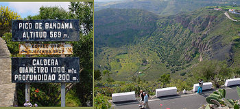
- Bandama CalderaBandama CalderaThe Bandama Natural Monument is part of the Tafira Protected Landscape on the island of Gran Canaria in the Canary Islands, Spain. It's considered a point of geological interest, because of the Caldera de Bandama...
(The Caldera de Bandama Natural Monument). The interior features the volcanic crater named Caldera de Bandama 1 km from the Monte Lentiscal area.
Other
Santa Brígida has schools, lyceums, a few gymnasia, a few churches, a post office, parks and a squares (plaza).- Bandama CalderaBandama CalderaThe Bandama Natural Monument is part of the Tafira Protected Landscape on the island of Gran Canaria in the Canary Islands, Spain. It's considered a point of geological interest, because of the Caldera de Bandama...
(Bandama Natural Monument) in Santa Brígida, Las PalmasSanta Brígida, Las PalmasVilla de Santa Brígida is a Canarian municipality in the northeastern portion of the island of Gran Canaria in the Province of Las Palmas of the Canary Islands. The suburbs of Las Palmas. The population is 18,817 , its density is 790.3/km² and the area is 23.81 km²...
is part of the Tafira Protected Landscape. It's considered a point of geological interest, because of the Caldera de Bandama. This volcanic calderaCalderaA caldera is a cauldron-like volcanic feature usually formed by the collapse of land following a volcanic eruption, such as the one at Yellowstone National Park in the US. They are sometimes confused with volcanic craters...
reaches 569 m (1,866.8 ft) above sea level at the highest point on its rim, Pico de Bandama, and is about 1000 m (3,280.8 ft) wide and 200 m (656.2 ft) deep. The steep walk to the bottom of the caldera takes about half an hour. Volcanic ash of different hues is in great abundance, and there are some interesting botanic species of Canary Islands origin. There are facilities for food and refreshments as well. - Archaeological sites in Santa Brígida. In the valley of La Angostura and Las Meleguinas can find numerous traces of Aboriginal canaries that have prompted the declaration of the area as a Cultural, as groups of caves carved into rock, silos or sidewalks. In the archaeological site of El Tope, discovered on 16 July 1988, where you can see remnants that suggest the existence of an aboriginal burial mound, as well as ceramics, pottery and curious pintaderas. En la pared norte de la Caldera de Bandama se encuentra la Cueva de los Canarios, utilizada por los aborígenes como granero. It has been discovered Libyan-Berber inscriptions and some vessels (which are now in the Museo Canario). Also in the same area in the wall of the volcano in the stew is the Cueva de Los Frailes was discovered in 1933 a set of 37 caves.
External links
- Map and aerial photos
- Street map from Mapquest n MapPoint or Google or Yahoo! Maps
- Google or Microsoft Virtual Earth - image now available
- Coordinates: 28°2′0"N 15°30′0"W
See also
| North: Las Palmas de Gran Canaria Las Palmas de Gran Canaria Las Palmas de Gran Canaria commonly known as Las Palmas is the political capital, jointly with Santa Cruz, the most populous city in the Autonomous Community of the Canary Islands and the ninth largest city in Spain, with a population of 383,308 in 2010. Nearly half of the people of the island... |
||
| West: Teror Teror Teror is a Canarian municipality in the northern portion of the island of Gran Canaria in the Las Palmas province in the Canary Islands. Teror is a suburb of Las Palmas city... |
Santa Brígida | East: Telde Telde, Las Palmas Telde is a municipality in the eastern on the island of Gran Canaria, Canary Islands, Spain. The suburb of Las Palmas city. It is the second most populated municipality on the island, with a population of 100,015... |
| Southwest: Vega de San Mateo | South: Valsequillo |