

San Ildefonso Pueblo, New Mexico
Encyclopedia
San Ildefonso Pueblo is a census-designated place
(CDP) in Santa Fe County
, New Mexico
, United States
. It is part of the Santa Fe, New Mexico
Metropolitan Statistical Area. The population was 458 at the 2000 census. San Ildefonso Pueblo is a member of the Eight Northern Pueblos
, and the pueblo people
are from the Tewa ethnic group of Native Americans
, who speak the Tewa language
.
According to the United States Census Bureau
, the CDP has a total area of 4.2 square miles (10.9 km²), of which, 3.9 square miles (10.1 km²) of it is land and 0.2 square mile (0.517997622 km²) of it (5.54%) is water.
San Ildefonso Pueblo is located at the foot of the Pajarito Plateau
just 12.87 km (8 mi) east from Los Alamos, New Mexico
, 38.6 km (24 mi) NW of Santa Fe, New Mexico
. A large volcanic outcroping lies directly north of San Ildefonso Pueblo, it is called the "Black Mesa." The Rio Grande
runs through San Ildefonso Pueblo and the lowest elevation is approximately 1676 meters (5500 feet).
of 2000, there were 458 people, 150 households, and 118 families residing in the CDP. The population density
was 116.7 people per square mile (45.1/km²). There were 178 housing units at an average density of 45.4 per square mile (17.5/km²). The racial makeup of the CDP was 16.16% White, 79.48% Native American, 2.84% from other races
, and 1.53% from two or more races. Hispanic or Latino of any race were 10.48% of the population.
There were 150 households out of which 38.7% had children under the age of 18 living with them, 48.0% were married couples living together, 24.0% had a female householder with no husband present, and 20.7% were non-families. 15.3% of all households were made up of individuals and 6.7% had someone living alone who was 65 years of age or older. The average household size was 3.05 and the average family size was 3.43.
In the CDP the population was spread out with 31.4% under the age of 18, 10.0% from 18 to 24, 26.4% from 25 to 44, 22.5% from 45 to 64, and 9.6% who were 65 years of age or older. The median age was 32 years. For every 100 females there were 90.8 males. For every 100 females age 18 and over, there were 98.7 males.
The median income for a household in the CDP was $30,000, and the median income for a family was $30,972. Males had a median income of $19,792 versus $19,250 for females. The per capita income
for the CDP was $11,039. About 19.1% of families and 14.9% of the population were below the poverty line, including none of those under age 18 and 50.0% of those age 65 or over.
. These people had first moved to Bandelier
just south of present-day Los Alamos. There these people thrived due to the rainfall (elevation about 7000 feet) and the ease of constructing living structures from the surrounding soft volcanic rock. But after a prolonged drought, the people moved down into the valleys of the Rio Grande around 1300 AD (Pueblo IV Era
). The Rio Grande and other arroyos
provided the water for irrigation.
 The Spanish
conquistador
s tried to subdue the native people and force their religion on the native people during the early 17th century, which lead to the Pueblo Revolt
of 1680. The people withstood the Spaniards by climbing to the top of the Black Mesa. The siege ended with the surrender of the native people, but the Spanish gave the native people some freedom of religion and other self-governing rights.
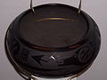
The pueblo natives continued to lead an agricultural based economy until the early 20th century when Maria Martinez
and her husband Julian Martinez
rediscovered how to make the Black-on Black pottery
for which San Ildefonso Pueblo would soon become famous. From that time the pueblo has become more tourist-oriented, with numerous tourist shops existing in the Pueblo. Because of close proximity to the state capital, Santa Fe, and the presence of the Los Alamos National Laboratory
, many of those employed in the pueblo have government jobs.
Census-designated place
A census-designated place is a concentration of population identified by the United States Census Bureau for statistical purposes. CDPs are delineated for each decennial census as the statistical counterparts of incorporated places such as cities, towns and villages...
(CDP) in Santa Fe County
Santa Fe County, New Mexico
-2010:Whereas according to the 2010 U.S. Census Bureau:*76.2% White*0.9% Black*3.1% Native American*1.2% Asian*0.1% Native Hawaiian or Pacific Islander*3.6% Two or more races*14.9% Other races*50.6% Hispanic or Latino -2000:...
, New Mexico
New Mexico
New Mexico is a state located in the southwest and western regions of the United States. New Mexico is also usually considered one of the Mountain States. With a population density of 16 per square mile, New Mexico is the sixth-most sparsely inhabited U.S...
, United States
United States
The United States of America is a federal constitutional republic comprising fifty states and a federal district...
. It is part of the Santa Fe, New Mexico
Santa Fe, New Mexico
Santa Fe is the capital of the U.S. state of New Mexico. It is the fourth-largest city in the state and is the seat of . Santa Fe had a population of 67,947 in the 2010 census...
Metropolitan Statistical Area. The population was 458 at the 2000 census. San Ildefonso Pueblo is a member of the Eight Northern Pueblos
Eight Northern Pueblos
The Eight Northern Pueblos of New Mexico are Taos, Picuris, Santa Clara, San Juan, San Ildefonso, Nambé, Pojoaque, and Tesuque.Taos and Picuris are Tiwa-speaking pueblos; the rest speak Tewa. Tiwa and Tewa are closely related languages of the Kiowa Tanoan language family...
, and the pueblo people
Pueblo people
The Pueblo people are a Native American people in the Southwestern United States. Their traditional economy is based on agriculture and trade. When first encountered by the Spanish in the 16th century, they were living in villages that the Spanish called pueblos, meaning "towns". Of the 21...
are from the Tewa ethnic group of Native Americans
Native Americans in the United States
Native Americans in the United States are the indigenous peoples in North America within the boundaries of the present-day continental United States, parts of Alaska, and the island state of Hawaii. They are composed of numerous, distinct tribes, states, and ethnic groups, many of which survive as...
, who speak the Tewa language
Tewa language
Tewa is a Kiowa–Tanoan language spoken by Pueblo people, mostly in the Rio Grande valley in New Mexico north of Santa Fe. The 1980 census counted 1,298 speakers, almost all of whom are bilingual in English...
.
Geography
San Ildefonso Pueblo is located at 35°53′52"N 106°7′19"W (35.897902, -106.121834).According to the United States Census Bureau
United States Census Bureau
The United States Census Bureau is the government agency that is responsible for the United States Census. It also gathers other national demographic and economic data...
, the CDP has a total area of 4.2 square miles (10.9 km²), of which, 3.9 square miles (10.1 km²) of it is land and 0.2 square mile (0.517997622 km²) of it (5.54%) is water.
San Ildefonso Pueblo is located at the foot of the Pajarito Plateau
Pajarito Plateau
The Pajarito Plateau is a volcanic plateau in north central New Mexico, United States. The plateau, part of the Jemez Mountains, is bounded on the west by the Valles Caldera and on the east by the White Rock Canyon of the Rio Grande...
just 12.87 km (8 mi) east from Los Alamos, New Mexico
Los Alamos, New Mexico
Los Alamos is a townsite and census-designated place in Los Alamos County, New Mexico, United States, built upon four mesas of the Pajarito Plateau and the adjoining White Rock Canyon. The population of the CDP was 12,019 at the 2010 Census. The townsite or "the hill" is one part of town while...
, 38.6 km (24 mi) NW of Santa Fe, New Mexico
Santa Fe, New Mexico
Santa Fe is the capital of the U.S. state of New Mexico. It is the fourth-largest city in the state and is the seat of . Santa Fe had a population of 67,947 in the 2010 census...
. A large volcanic outcroping lies directly north of San Ildefonso Pueblo, it is called the "Black Mesa." The Rio Grande
Rio Grande
The Rio Grande is a river that flows from southwestern Colorado in the United States to the Gulf of Mexico. Along the way it forms part of the Mexico – United States border. Its length varies as its course changes...
runs through San Ildefonso Pueblo and the lowest elevation is approximately 1676 meters (5500 feet).
Demographics
As of the censusCensus
A census is the procedure of systematically acquiring and recording information about the members of a given population. It is a regularly occurring and official count of a particular population. The term is used mostly in connection with national population and housing censuses; other common...
of 2000, there were 458 people, 150 households, and 118 families residing in the CDP. The population density
Population density
Population density is a measurement of population per unit area or unit volume. It is frequently applied to living organisms, and particularly to humans...
was 116.7 people per square mile (45.1/km²). There were 178 housing units at an average density of 45.4 per square mile (17.5/km²). The racial makeup of the CDP was 16.16% White, 79.48% Native American, 2.84% from other races
Race (United States Census)
Race and ethnicity in the United States Census, as defined by the Federal Office of Management and Budget and the United States Census Bureau, are self-identification data items in which residents choose the race or races with which they most closely identify, and indicate whether or not they are...
, and 1.53% from two or more races. Hispanic or Latino of any race were 10.48% of the population.
There were 150 households out of which 38.7% had children under the age of 18 living with them, 48.0% were married couples living together, 24.0% had a female householder with no husband present, and 20.7% were non-families. 15.3% of all households were made up of individuals and 6.7% had someone living alone who was 65 years of age or older. The average household size was 3.05 and the average family size was 3.43.
In the CDP the population was spread out with 31.4% under the age of 18, 10.0% from 18 to 24, 26.4% from 25 to 44, 22.5% from 45 to 64, and 9.6% who were 65 years of age or older. The median age was 32 years. For every 100 females there were 90.8 males. For every 100 females age 18 and over, there were 98.7 males.
The median income for a household in the CDP was $30,000, and the median income for a family was $30,972. Males had a median income of $19,792 versus $19,250 for females. The per capita income
Per capita income
Per capita income or income per person is a measure of mean income within an economic aggregate, such as a country or city. It is calculated by taking a measure of all sources of income in the aggregate and dividing it by the total population...
for the CDP was $11,039. About 19.1% of families and 14.9% of the population were below the poverty line, including none of those under age 18 and 50.0% of those age 65 or over.
History
The pueblo (Spanish for town) was founded when people came from the Mesa Verde complex in Southern ColoradoColorado
Colorado is a U.S. state that encompasses much of the Rocky Mountains as well as the northeastern portion of the Colorado Plateau and the western edge of the Great Plains...
. These people had first moved to Bandelier
Bandelier National Monument
Bandelier National Monument is a National Monument preserving the homes of the Ancestral Pueblo People. It is named after Swiss anthropologist Adolph Bandelier, who researched the cultures of the area. Bandelier was designated a National Monument on February 11, 1916, and most of its backcountry...
just south of present-day Los Alamos. There these people thrived due to the rainfall (elevation about 7000 feet) and the ease of constructing living structures from the surrounding soft volcanic rock. But after a prolonged drought, the people moved down into the valleys of the Rio Grande around 1300 AD (Pueblo IV Era
Pueblo IV Era
The Pueblo IV Era, was the fourth period of ancient pueblo life in the American Southwest. At the end of prior Pueblo III Era, Anasazi living in the Colorado and Utah regions abandoned their settlements and migrated south to the Little Colorado River and Rio Grande River valleys...
). The Rio Grande and other arroyos
Arroyo (creek)
An arroyo , a Spanish word translated as brook, and also called a wash is usually a dry creek or stream bed—gulch that temporarily or seasonally fills and flows after sufficient rain. Wadi is a similar term in Africa. In Spain, a rambla has a similar meaning to arroyo.-Types and processes:Arroyos...
provided the water for irrigation.
Spanish people
The Spanish are citizens of the Kingdom of Spain. Within Spain, there are also a number of vigorous nationalisms and regionalisms, reflecting the country's complex history....
conquistador
Conquistador
Conquistadors were Spanish soldiers, explorers, and adventurers who brought much of the Americas under the control of Spain in the 15th to 16th centuries, following Europe's discovery of the New World by Christopher Columbus in 1492...
s tried to subdue the native people and force their religion on the native people during the early 17th century, which lead to the Pueblo Revolt
Pueblo Revolt
The Pueblo Revolt of 1680, or Popé's Rebellion, was an uprising of several pueblos of the Pueblo people against Spanish colonization of the Americas in the province of Santa Fe de Nuevo México.-Background:...
of 1680. The people withstood the Spaniards by climbing to the top of the Black Mesa. The siege ended with the surrender of the native people, but the Spanish gave the native people some freedom of religion and other self-governing rights.
The pueblo natives continued to lead an agricultural based economy until the early 20th century when Maria Martinez
Maria Martinez
Maria Montoya Martinez was a Native American artist who created internationally known pottery...
and her husband Julian Martinez
Julian Martinez
Julian Martinez, also known as Pacano, was a Native American potter and the patriarch of the most important family of Native American artisans in the United States. Born on the San Ildefonso Pueblo in New Mexico, Martinez was instrumental in reviving the black San Ildefonso pottery and Santa Clara...
rediscovered how to make the Black-on Black pottery
Native American pottery
Native American pottery is an art form with at least a 7500-year history in the Americas. Pottery is fired ceramics with clay as a component. Ceramics are used for utilitarian cooking vessels, serving and storage vessels, pipes, funerary urns, censers, musical instruments, ceremonial items, masks,...
for which San Ildefonso Pueblo would soon become famous. From that time the pueblo has become more tourist-oriented, with numerous tourist shops existing in the Pueblo. Because of close proximity to the state capital, Santa Fe, and the presence of the Los Alamos National Laboratory
Los Alamos National Laboratory
Los Alamos National Laboratory is a United States Department of Energy national laboratory, managed and operated by Los Alamos National Security , located in Los Alamos, New Mexico...
, many of those employed in the pueblo have government jobs.
See also
- Maria MartinezMaria MartinezMaria Montoya Martinez was a Native American artist who created internationally known pottery...
- Tsankawi cliff dwellingsTsankawiTsankawi is a detached portion of Bandelier National Monument in New Mexico, near White Rock. It is accessible from a roadside parking area just north of the intersection of East Jemez Road and State Road 4. A self-guided 1.5 mile loop trail provides access to numerous unexcavated ruins, caves...
- Tsirege archaeological siteTsiregeTsirege is a classic Anasazi Pueblo archaeological site located north of Pajarito Road about one mile west of White Rock, New Mexico on property owned by Los Alamos National Laboratory...