

San Francisco-Oakland Bay Bridge
Encyclopedia
The San Francisco – Oakland Bay Bridge (known locally as the Bay Bridge) is a pair of bridges spanning San Francisco Bay
of California
, in the United States. Forming part of Interstate 80 and of the direct road route between San Francisco and Oakland
, it carries approximately 270,000 vehicles per day on its two decks. It has one of the longest spans in the world.
The toll bridge
was conceived as early as the gold rush
days, but construction did not begin until 1933. Designed by Charles H. Purcell, and built by American Bridge Company
, it opened for traffic on November 12, 1936, six months before the Golden Gate Bridge
. It originally carried automobile traffic on its upper deck, and trucks and trains on the lower, but after the closure of the Key System
, the lower deck was converted to road traffic as well.
The bridge was closed on October 27, 2009 due to failure of part of the recently-repaired eastern span. It reopened on November 2.
In 1986, the bridge was unofficially dedicated to James B. Rolph
.
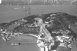
, a natural outcropping located mid-bay. The Western crossing lies between Yerba Buena and San Francisco. It is composed of two complete suspension spans connected at a center anchorage. The top of the Rincon Hill
neighborhood serves as the western anchorage and touch-down for the San Francisco landing of the bridge connected by three shorter truss spans. The eastern crossing, between Yerba Buena Island and Oakland, is a cantilever bridge
that consists of a double-tower span, five medium truss spans, and a 14-section truss causeway
. Due to earthquake concerns the eastern crossing is being replaced by an entirely new crossing, to be finished in late 2013. On Yerba Buena Island, the double-decked crossing consists of a 321 feet (97.8 m) concrete viaduct
east of the west span's cable anchorage, a 540 feet (164.6 m) tunnel
through the island's rocky central hill, another 790.8 feet (241 m) concrete viaduct, and a longer curved high-level steel truss viaduct that spans the final 1169.7 feet (356.5 m) to the cantilever bridge. The viaduct sections east of the tunnel are at present being modified, bypassed and replaced as part of the seismic safety work that will eventually transition traffic onto and off of the self-anchored suspension (SAS) bridge of the new eastern bay crossing.
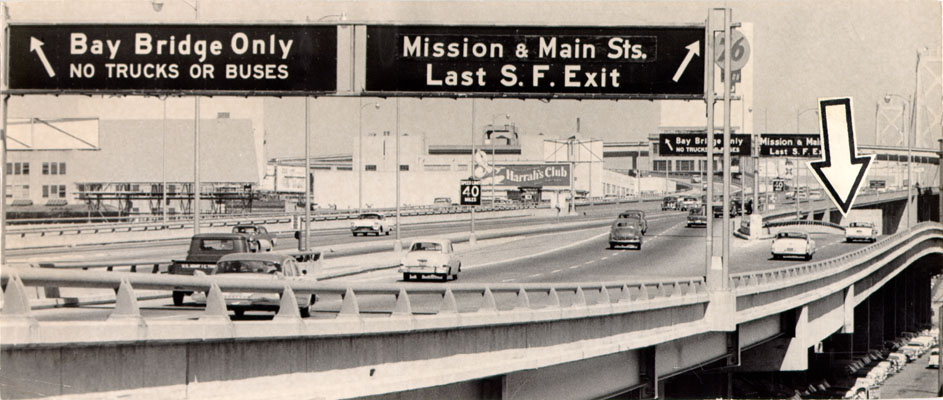
The toll plaza on the Oakland side (since 1969 for westbound traffic only) has eighteen toll lanes, of which six are dedicated FasTrak
lanes. Mainline metering signals are located approximately 600 feet (182.9 m) west of the toll plaza. Two full-time bus-only lanes bypass the toll booths and metering lights around the right (north) side of the toll plaza; other high occupancy vehicles are permitted to use these lanes during weekday morning and afternoon commute periods. The two far-left toll lanes are operated as high-occupancy vehicle lane
s during weekday morning and afternoon commute periods. During the morning commute hours, traffic congestion on the Oakland approach stretches back onto the three feeder highways
, Interstate 580, Interstate 880, and Interstate 80
toward Richmond, California
. Since the number of lanes on the San Francisco approach is structurally restricted, backups
are frequent in the eastbound direction during evening commute hours. The bridge is currently restricted to motorized freeway traffic. Pedestrians, bicycles, and other non-freeway vehicles and devices are not allowed. A California Department of Transportation
(Caltrans) bicycle shuttle operates during peak commute hours for $1.00 each way.
Freeway ramps next to the tunnel provide access to Yerba Buena Island and Treasure Island. Because the toll plaza is on the Oakland side, traffic between the island and San Francisco can freely cross back and forth without ever paying a toll. Those who only travel from Oakland to Yerba Buena Island, and not the entire length to San Francisco, must still pay the full toll.
. Almost all goods not produced locally arrived by ship. But after the first transcontinental railroad
was completed in May 1869, San Francisco found itself to be on the wrong side of the bay, separated from the new rail link. The fear of many San Franciscans was that the city would lose its position as the regional center of trade. The concept of a bridge spanning the San Francisco Bay had been considered since the Gold Rush days. Several newspaper articles during the early 1870s discussed the idea. In early 1872, a "Bay Bridge Committee" was hard at work on plans to construct a railroad bridge. The April 1872 issue of the San Francisco Real Estate Circular contained an item about the committee:
The self-proclaimed Emperor Norton I saw fit to decree several times that a suspension bridge be constructed to connect Oakland with San Francisco. Later in 1872, frustrated that nothing had happened, Norton decreed:
 Unlike most of Emperor Norton's eccentric ideas, his decree to build a bridge had wide public and political appeal. Yet, the task was too much of an engineering and economic challenge since the bay was too wide and too deep there. In 1921, over forty years after Norton's death, a tunnel was considered, but it became clear that one would be inadequate for vehicular traffic. Support for a trans-bay crossing finally grew in the 1920s with the increasing popularity and availability of the automobile. In 1929, the California Legislature established the California Toll Bridge Authority with the responsibility of connecting San Francisco and Alameda County
with a bridge.
To make the bridge design feasible, its route was chosen to pass through Yerba Buena Island
(formerly known as Goat Island in 1870s), significantly reducing the amount of material and construction labor needed to build a trans-bay crossing. Yerba Buena Island was a U.S. Navy base at the time (and until 1997). So the approval of the U.S. Congress, which regulates the armed services and supervises all naval and military bases, was necessary for this island to be used. After a great deal of lobbying, California received Congressional approval to use the island on February 20, 1931.
 The chief engineer was Ralph Modjeski
. Construction began on July 9, 1933. The western span of the bridge between San Francisco and Yerba Buena Island presented an enormous engineering situation. The bay was up to 100 feet (30.5 m) deep in places and the soil required new foundation-laying techniques. A single main suspension span some 4100 feet (1.245km) in length was considered but rejected, as it would have required too much fill and reduced wharfage space at San Franciso, had less vertical clearance for shipping, and cost more than the design ultimately adopted. The solution was to construct a massive concrete anchorage halfway between San Francisco and the island, and to build a main suspension span on each side of this central anchorage.
East of Yerba Buena Island, the bay to Oakland was spanned by a 10176 feet (3,101.6 m) combination of double cantilever, five long-span through-trusses, and a truss causeway, forming the longest bridge of its kind at the time. The cantilever section was longest in the nation and third-longest anywhere.
Much of the original eastern span is founded upon treated wood. Because of the very deep mud on the bay bottom it was not practical to reach bedrock, although the lower levels of the mud are quite firm. Long wooden pilings were crafted from entire old-growth Douglas fir trees which were driven through the soft mud to the firmer bottom layers.
 Connecting the two halves of the bridge is Yerba Buena Tunnel, measuring 76 feet (23.2 m) wide, 58 feet (17.7 m) high, and 540 feet (164.6 m) long. It is the largest diameter transportation bore tunnel in the world.
Reminders of the long-gone bridge railway survive along the south side of the lower Yerba Buena Tunnel. These are the regularly spaced "deadman holes" along the wall, into which track workers could duck if a train came along. (The north side, which always carried only motor traffic, lacks these holes.)
Herbert Hoover
, Senator William G. McAdoo, and the Governor of California
, Frank Merriam
. Governor Merriam officially opened the bridge by cutting gold chains across the traffic lanes with an acetylene
cutting torch
. The San Francisco Chronicle
report of November 13, 1936, read:
The total cost of construction for the bridge was $77 million. Prior to its opening, the bridge was blessed by Cardinal Secretary of State
Eugene Cardinal Pacelli, who later became Pope Pius XII
. Because it was in effect two bridges strung together, the western spans were ranked the second and third largest suspension bridges. Only the George Washington Bridge
had a longer span between towers.
 The original western approach to (and exit from) the upper deck of the bridge was a long ramp to Fifth, branching to Harrison St for westward traffic off the bridge and Bryant St for eastward traffic entering. There was also an on-ramp to the upper deck on Rincon Hill
from Fremont Street (that later became an off-ramp) and an off-ramp to First Street (later extended over First St to Fremont St). The lower deck ended at Essex and Harrison St; just southwest of there, the tracks of the bridge railway left the lower deck and curved northward into the elevated loop through the Transbay Terminal that was paved for buses after rail service ended.
There were three original eastern approaches: a viaduct from the end of Cypress Street (State Route 17) in Oakland; a viaduct from the end of 38th Street (U.S. Route 50) at San Pablo Avenue in Oakland; and the Eastshore Highway which carried U.S. Route 40 along the shoreline of Albany
, Berkeley
and Emeryville
.
Until the 1960s the upper deck (58 feet (17.7 m) wide between curbs) carried three lanes of traffic in each direction and was restricted to automobiles only. Eastward view after freeways The lower deck carried three lanes of truck and auto traffic on the north side. In the 1950s traffic lights were added to set the direction of travel in the middle lane, but still with no divider. Two railroad tracks on the south half of the lower deck carried the electric commuter trains of the Southern Pacific
, the Key System
, and the Sacramento Northern railroad, although train service across the bridge to the San Francisco Transbay Terminal
did not begin until January 15, 1939. An overhead catenary
supplied power to the Southern Pacific and Sacramento Northern trains while the Key trains used a third rail
. After 1941 only the Key System used these tracks; railroad service on the bridge ended in April 1958.
The Bay Bridge rebuilding (five westbound lanes on the upper deck and five eastbound lanes on the lower deck) was completed October 12, 1963. Tolls were collected in both directions until September 1969, when toll collection from westbound traffic only began.
The Federal highway on the bridge was originally a concurrency
of U.S. Highway 40 and U.S. Highway 50. The bridge was re-designated as Interstate 80 in 1964, and U.S. 40 and U.S. 50 were eventually cut back to Utah
and Sacramento
, respectively.
The off-ramps for Treasure Island
and Yerba Buena Island
are unusual in that they are on the left-hand side both in the eastbound and westbound directions. Eastbound and westbound on-ramps are on the usual right-hand side, but they do not have dedicated merge lanes; drivers must accelerate from a stop sign
to freeway speeds in a short distance.
declined, and in October 1963, the Bay Bridge was reconfigured with five lanes of westbound traffic on the upper deck and five lanes of eastbound traffic on the lower deck. Trucks were allowed on both decks and the railroad was removed. Owing to a lack of clearance for trucks through the upper-deck portion of the Yerba Buena tunnel, it was necessary to lower the elevation of the upper deck where it passes through the tunnel, and to correspondingly excavate to lower the elevation of the lower portion. This work was done while the Bay Bridge was in use by using a movable temporary span over the portion being lowered. On the lower deck of the tunnel and its eastern viaduct extension, it was necessary to remove central supports, with each transverse beam (of reinforced concrete) being doubled to take the load across all lanes. It was also necessary to further reinforce each beam supporting the upper deck throughout the entire span, modifications still visible to the traveler.
On February 11, 1968, a U.S. Navy
T-33 Shooting Star
training aircraft, flying out of the nearby Naval Air Station Alameda
, crashed into the eastern span of the bridge, killing both officers. One of the truss sections of the bridges was replaced due to damage from the impact.
The series of lights adorning the suspension cables was added in 1986 as part of the bridge's 50th-anniversary celebration.
 During the October 17, 1989, Loma Prieta earthquake
, which measured 6.9 on the moment magnitude scale
, a 50 feet (15.2 m) section of the upper deck of the eastern truss
portion of the bridge at Pier E9 collapsed onto the deck below, indirectly causing one death. The bridge was closed for just over a month as construction crews repaired the section. It reopened on November 18 of that year. The lighter pavement of the replacement section is visible in aerial photographs, at the east end of the through-truss part of the bridge (37.8189°N 122.3442°W).
ting. During the retrofit, much of the structural steel
supporting the bridge deck was replaced while the bridge remained open to traffic. Engineers accomplished this by using methods similar to those employed on the Chicago Skyway
reconstruction project.
The entire bridge was fabricated using hot steel rivets, which are impossible to heat treat and so remain relatively soft. Analysis showed that these could fail by shearing under extreme stress, and so at most locations each was removed by burning out with an oxygen cutting
torch, the hole precision reamed
and the old rivets replaced with heat-treated high-strength locator bolts and nuts. This work had to be performed with great care as the steel of the structure had for many years been painted with lead
based paint, which had to be carefully removed and contained by workers with extensive protective gear.
.jpg) Most of the beams were originally constructed of two plate
Most of the beams were originally constructed of two plate
Diagonal box beams have been added to each bay of the upper and lower decks of the western spans. These add stiffness to reduce side-to-side motion during an earthquake and reduce the probability of damage to the decking surfaces.
Analysis showed that some massive concrete supports could burst and crumble under likely stresses. In particular the western supports were extensively modified. First, the location of existing reinforcing bar is determined using magnetic techniques. In areas between bars holes are drilled. Into these holes is inserted and glued an L-shaped bar that protrudes 15 to 25 centimeters (6 to 10 inches). This bar is retained in the hole with a high-strength epoxy
adhesive. The entire surface of the structure is thus covered with closely spaced protrusions. A network of horizontal and vertical reinforcing bars is then attached to these protrusions. Mold surface plates are then positioned to retain high-strength concrete, which is then pumped into the void. After removal of the formwork the surface appears similar to the original concrete. This technique has been applied elsewhere throughout California to improve freeway overpass abutments and some overpass central supports which have unconventional shapes. (Other techniques such as jacket and grout are applied to simple vertical posts; see the seismic retrofit
article.)
The western approaches have also been retrofitted in part, but mostly these have been replaced with new construction of reinforced concrete.
will carry recreational and commuter cyclists between Oakland and Yerba Buena Island. The opening date for the new span is projected to be in late 2013.
Eastern Span – Original and Replacement
, significant enough to warrant bridge closure. Working in parallel with the retrofit, California Department of Transportation
(Caltrans), and its contractors and subcontractors, were able to design, engineer, fabricate, and install the pieces required to repair the bridge, delaying its planned opening by only 1½ hours. The repair was not inspected by the Federal Highway Administration
, who relied on state inspection reports to ensure safety guidelines were met.
On October 27, 2009, during the evening commute, the steel crossbeam and two steel tie rods repaired over Labor Day
weekend
snapped off the Bay Bridge's eastern span and fell to the upper deck. The cause may have been due to metal-on-metal vibration from bridge traffic and wind gusts of up to 55 miles per hour (88.5 km/h) causing failure of one rod which broke off, which then led to the metal section crashing down. Three vehicles were either struck by or hit the fallen debris, though there were no injuries. On November 1, Caltrans announced that the bridge would probably stay closed at least through the morning commute of Monday, November 2, after repairs performed during the weekend failed a stress test on Sunday. BART and the Golden Gate Ferry
systems added supplemental service to accommodate the increased passenger load during the bridge closure. The bridge reopened to traffic on November 2, 2009.
The pieces which broke off on October 27 were a saddle, crossbar
s, and two tension rods. For additional details see the Eastern span replacement of the San Francisco-Oakland Bay Bridge
article.
Bridge — but this name has rarely been used, and it was not widely recognized until the bridge's 50th-anniversary celebrations in 1986. The official name of the bridge for all functional purposes has always been the San Francisco – Oakland Bay Bridge, and by most local people it is widely referred to as simply "The Bay Bridge".
James Rolph, a Mayor of San Francisco
from 1912 to 1931, was the Governor of California
at the time construction began. He died in office on June 2, 1934, two years before the bridge opened, leaving the bridge to be named for him out of respect. However, due to the opposition of Joseph R. Knowland
, publisher of the Oakland Tribune at the time, recognition of Rolph was withheld. In 1932, with an inability to finance the bridge, Joseph R. Knowland, (a former US Congressman) travelled to Washington and helped to persuade President Herbert Hoover
and the Reconstruction Finance Corporation
to advance $62 million for the building of the bridge.
Emperor Norton's early work at promoting a bridge between the city and county of San Francisco and the city of Oakland and Alameda County was commemorated on December 14, 2004, when the San Francisco Board of Supervisors
approved a resolution calling for the new eastern span of the bridge to be named "The Emperor Norton Bridge". The resolution was introduced by San Francisco County Supervisor Aaron Peskin
. Neither the city of Oakland nor Alameda County passed any similar resolution.
Plaques honoring the contributions of both Rolph and Norton exist. The Rolph plaque, originally placed at the west end of the bridge in San Francisco, was moved to the corner of Fifth and Bryant Streets in 1986 and removed entirely by Caltrans in 2006. The plaque honoring Emperor Norton for the original idea graced the western archway of the Transbay Terminal, the public transit depot, and the Greyhound bus depot at the west end of the bridge in downtown San Francisco.
In the interest of reducing the cost of collecting tolls and of building additional toll booths, all bridges in the Bay Area were converted to collect tolls in only one direction, with the toll amount collected doubled.
Tolls were subsequently raised to finance improvements to the bridge approaches, required to connect with new freeways, and to subsidize public transit in order to reduce the traffic over the bridge.
Caltrans, the state highway transportation agency, maintains seven of the eight San Francisco Bay Area bridges. (The Golden Gate Bridge is owned and maintained by the Golden Gate Bridge, Highway and Transportation District
.)
The basic toll (for automobiles) on the seven state bridges was raised to $1 by Regional Measure 1, approved by Bay Area voters in 1988. A $1 seismic retrofit surcharge was added in 1998 by the state legislature, originally for eight years, but since then extended to December 2037 (AB1171, October 2001). On March 2, 2004, voters approved Regional Measure 2, raising the toll by another dollar to a total of $3. An additional dollar was added to the toll starting January 1, 2007, to cover cost overruns concerning the replacement of the eastern span.
The Metropolitan Transportation Commission
, a regional transportation agency, in its capacity as the Bay Area Toll Authority, administers RM1 and RM2 funds, a significant portion of which are allocated to public transit capital improvements and operating subsidies in the transportation corridors served by the bridges. Caltrans administers the "second dollar" seismic surcharge, and receives some of the MTC-administered funds to perform other maintenance work on the bridges. The Bay Area Toll Authority is made up of appointed officials put in place by various city and county governments, and is not subject to direct voter oversight.
Due to further funding shortages for seismic retrofit projects, the Bay Area Toll Authority again raised tolls on all Bay Area bridges (excluding the Golden Gate Bridge
) in July 2010. The toll rate for autos on other Bay Area bridges was increased to $5, but in the Bay Bridge a variable pricing
tolling
scheme based on congestion was implemented. The Bay Bridge congestion pricing
scheme charges a toll from 5 a.m. to 10 a.m. and 3 p.m. to 7 p.m., Monday through Friday. During weekends cars pay . Carpools before the implementation were exempted but now they pay , and the carpool toll discount is now also available only to drivers with FasTrak
electronic toll devices. The toll remained at the previous toll of at all other times on weekdays. The Bay Area Toll Authority reported that by October 2010 fewer users are driving during the peak hours and more vehicles are crossing the Bay Bridge before and after the 5-10 a.m. period in which the congestion toll goes into effect. Commute delays in the first six months dropped by an average of 15% compared with 2009.
, The Graduate
, Koyaanisqatsi
, George of the Jungle
, 2012
, Basic Instinct
, The Towering Inferno
, and The Dead Pool
. The bridge has appeared in the video games Resistance 2
,"Need for Speed: The Run
, Midtown Madness 2
, Grand Theft Auto: San Andreas
and Rig'n'Roll
. It has also appeared in such science fiction novels as William Gibson
's futuristic Bridge trilogy
and Cory Doctorow
's novel Little Brother
, as well as the graphic novel How Loathsome
. The new eastern span will appear in the Golden State Warriors
logo beginning in the 2011 season.
San Francisco Bay
San Francisco Bay is a shallow, productive estuary through which water draining from approximately forty percent of California, flowing in the Sacramento and San Joaquin rivers from the Sierra Nevada mountains, enters the Pacific Ocean...
of California
California
California is a state located on the West Coast of the United States. It is by far the most populous U.S. state, and the third-largest by land area...
, in the United States. Forming part of Interstate 80 and of the direct road route between San Francisco and Oakland
Oakland, California
Oakland is a major West Coast port city on San Francisco Bay in the U.S. state of California. It is the eighth-largest city in the state with a 2010 population of 390,724...
, it carries approximately 270,000 vehicles per day on its two decks. It has one of the longest spans in the world.
The toll bridge
Toll bridge
A toll bridge is a bridge over which traffic may pass upon payment of a toll, or fee.- History :The practice of collecting tolls on bridges probably harks back to the days of ferry crossings where people paid a fee to be ferried across stretches of water. As boats became impractical to carry large...
was conceived as early as the gold rush
California Gold Rush
The California Gold Rush began on January 24, 1848, when gold was found by James W. Marshall at Sutter's Mill in Coloma, California. The first to hear confirmed information of the gold rush were the people in Oregon, the Sandwich Islands , and Latin America, who were the first to start flocking to...
days, but construction did not begin until 1933. Designed by Charles H. Purcell, and built by American Bridge Company
American Bridge Company
The American Bridge Company is a privately held civil engineering firm specializing in the construction and renovation of bridges and other large civil engineering projects, founded in 1900, and headquartered in Coraopolis, Pennsylvania, a suburb of Pittsburgh.-Products and industry positioning:The...
, it opened for traffic on November 12, 1936, six months before the Golden Gate Bridge
Golden Gate Bridge
The Golden Gate Bridge is a suspension bridge spanning the Golden Gate, the opening of the San Francisco Bay into the Pacific Ocean. As part of both U.S. Route 101 and California State Route 1, the structure links the city of San Francisco, on the northern tip of the San Francisco Peninsula, to...
. It originally carried automobile traffic on its upper deck, and trucks and trains on the lower, but after the closure of the Key System
Key System
The Key System was a privately owned company which provided mass transit in the cities of Oakland, Berkeley, Alameda, Emeryville, Piedmont, San Leandro, Richmond, Albany and El Cerrito in the eastern San Francisco Bay Area from 1903 until 1960, when the system was sold to a newly formed public...
, the lower deck was converted to road traffic as well.
The bridge was closed on October 27, 2009 due to failure of part of the recently-repaired eastern span. It reopened on November 2.
In 1986, the bridge was unofficially dedicated to James B. Rolph
James Rolph
James “Sunny Jim” Rolph, Jr. was an American politician and a member of the Republican Party. He was elected to a single term as the 27th governor of California from January 6, 1931 until his death on June 2, 1934 at the height of the Great Depression...
.
Composition
The bridge consists of two major crossings connecting each shore with Yerba Buena IslandYerba Buena Island
Yerba Buena Island sits in the San Francisco Bay between San Francisco and Oakland, California. The Yerba Buena Tunnel runs through its center and connects the western and eastern spans of the San Francisco-Oakland Bay Bridge. It has had several other names over the decades: Sea Bird Island, Wood...
, a natural outcropping located mid-bay. The Western crossing lies between Yerba Buena and San Francisco. It is composed of two complete suspension spans connected at a center anchorage. The top of the Rincon Hill
Rincon Hill
Rincon Hill is a neighborhood in San Francisco, California. It is one of San Francisco's 44 hills, and one of its original "Seven Hills."-Location:...
neighborhood serves as the western anchorage and touch-down for the San Francisco landing of the bridge connected by three shorter truss spans. The eastern crossing, between Yerba Buena Island and Oakland, is a cantilever bridge
Cantilever bridge
A cantilever bridge is a bridge built using cantilevers, structures that project horizontally into space, supported on only one end. For small footbridges, the cantilevers may be simple beams; however, large cantilever bridges designed to handle road or rail traffic use trusses built from...
that consists of a double-tower span, five medium truss spans, and a 14-section truss causeway
Causeway
In modern usage, a causeway is a road or railway elevated, usually across a broad body of water or wetland.- Etymology :When first used, the word appeared in a form such as “causey way” making clear its derivation from the earlier form “causey”. This word seems to have come from the same source by...
. Due to earthquake concerns the eastern crossing is being replaced by an entirely new crossing, to be finished in late 2013. On Yerba Buena Island, the double-decked crossing consists of a 321 feet (97.8 m) concrete viaduct
Viaduct
A viaduct is a bridge composed of several small spans. The term viaduct is derived from the Latin via for road and ducere to lead something. However, the Ancient Romans did not use that term per se; it is a modern derivation from an analogy with aqueduct. Like the Roman aqueducts, many early...
east of the west span's cable anchorage, a 540 feet (164.6 m) tunnel
Tunnel
A tunnel is an underground passageway, completely enclosed except for openings for egress, commonly at each end.A tunnel may be for foot or vehicular road traffic, for rail traffic, or for a canal. Some tunnels are aqueducts to supply water for consumption or for hydroelectric stations or are sewers...
through the island's rocky central hill, another 790.8 feet (241 m) concrete viaduct, and a longer curved high-level steel truss viaduct that spans the final 1169.7 feet (356.5 m) to the cantilever bridge. The viaduct sections east of the tunnel are at present being modified, bypassed and replaced as part of the seismic safety work that will eventually transition traffic onto and off of the self-anchored suspension (SAS) bridge of the new eastern bay crossing.
The toll plaza on the Oakland side (since 1969 for westbound traffic only) has eighteen toll lanes, of which six are dedicated FasTrak
FasTrak
FasTrak is the electronic toll collection system used in the state of California in the United States. The system is used statewide on all of the toll roads, toll bridges, and high occupancy/toll and express toll lanes along the California Freeway and Expressway System.As with other ETC systems,...
lanes. Mainline metering signals are located approximately 600 feet (182.9 m) west of the toll plaza. Two full-time bus-only lanes bypass the toll booths and metering lights around the right (north) side of the toll plaza; other high occupancy vehicles are permitted to use these lanes during weekday morning and afternoon commute periods. The two far-left toll lanes are operated as high-occupancy vehicle lane
High-occupancy vehicle lane
In transportation engineering and transportation planning, a high-occupancy vehicle lane is a lane reserved for vehicles with a driver and one or more passengers...
s during weekday morning and afternoon commute periods. During the morning commute hours, traffic congestion on the Oakland approach stretches back onto the three feeder highways
MacArthur Maze
The MacArthur Maze refers to the large freeway interchange located near the eastern end of the San Francisco – Oakland Bay Bridge in Oakland, California and is the largest freeway interchange in the world...
, Interstate 580, Interstate 880, and Interstate 80
Interstate 80 in California
In the U.S. state of California, Interstate 80 , a major east–west route of the Interstate Highway System, has its western terminus in San Francisco, California, United States. From there it heads east across the Bay Bridge to Oakland, where it turns north and crosses the Carquinez Bridge...
toward Richmond, California
Richmond, California
Richmond is a city in western Contra Costa County, California, United States. The city was incorporated on August 7, 1905. It is located in the East Bay, part of the San Francisco Bay Area. It is a residential inner suburb of San Francisco, as well as the site of heavy industry, which has been...
. Since the number of lanes on the San Francisco approach is structurally restricted, backups
Traffic congestion
Traffic congestion is a condition on road networks that occurs as use increases, and is characterized by slower speeds, longer trip times, and increased vehicular queueing. The most common example is the physical use of roads by vehicles. When traffic demand is great enough that the interaction...
are frequent in the eastbound direction during evening commute hours. The bridge is currently restricted to motorized freeway traffic. Pedestrians, bicycles, and other non-freeway vehicles and devices are not allowed. A California Department of Transportation
California Department of Transportation
The California Department of Transportation is a government department in the U.S. state of California. Its mission is to improve mobility across the state. It manages the state highway system and is actively involved with public transportation systems throughout the state...
(Caltrans) bicycle shuttle operates during peak commute hours for $1.00 each way.
Freeway ramps next to the tunnel provide access to Yerba Buena Island and Treasure Island. Because the toll plaza is on the Oakland side, traffic between the island and San Francisco can freely cross back and forth without ever paying a toll. Those who only travel from Oakland to Yerba Buena Island, and not the entire length to San Francisco, must still pay the full toll.
Pre-construction
San Francisco, located at the mouth of the bay, was in a perfect location to prosper during the California Gold RushCalifornia Gold Rush
The California Gold Rush began on January 24, 1848, when gold was found by James W. Marshall at Sutter's Mill in Coloma, California. The first to hear confirmed information of the gold rush were the people in Oregon, the Sandwich Islands , and Latin America, who were the first to start flocking to...
. Almost all goods not produced locally arrived by ship. But after the first transcontinental railroad
First Transcontinental Railroad
The First Transcontinental Railroad was a railroad line built in the United States of America between 1863 and 1869 by the Central Pacific Railroad of California and the Union Pacific Railroad that connected its statutory Eastern terminus at Council Bluffs, Iowa/Omaha, Nebraska The First...
was completed in May 1869, San Francisco found itself to be on the wrong side of the bay, separated from the new rail link. The fear of many San Franciscans was that the city would lose its position as the regional center of trade. The concept of a bridge spanning the San Francisco Bay had been considered since the Gold Rush days. Several newspaper articles during the early 1870s discussed the idea. In early 1872, a "Bay Bridge Committee" was hard at work on plans to construct a railroad bridge. The April 1872 issue of the San Francisco Real Estate Circular contained an item about the committee:
The self-proclaimed Emperor Norton I saw fit to decree several times that a suspension bridge be constructed to connect Oakland with San Francisco. Later in 1872, frustrated that nothing had happened, Norton decreed:
Alameda County, California
Alameda County is a county in the U.S. state of California. It occupies most of the East Bay region of the San Francisco Bay Area. As of the 2010 census it had a population of 1,510,271, making it the 7th most populous county in the state...
with a bridge.
To make the bridge design feasible, its route was chosen to pass through Yerba Buena Island
Yerba Buena Island
Yerba Buena Island sits in the San Francisco Bay between San Francisco and Oakland, California. The Yerba Buena Tunnel runs through its center and connects the western and eastern spans of the San Francisco-Oakland Bay Bridge. It has had several other names over the decades: Sea Bird Island, Wood...
(formerly known as Goat Island in 1870s), significantly reducing the amount of material and construction labor needed to build a trans-bay crossing. Yerba Buena Island was a U.S. Navy base at the time (and until 1997). So the approval of the U.S. Congress, which regulates the armed services and supervises all naval and military bases, was necessary for this island to be used. After a great deal of lobbying, California received Congressional approval to use the island on February 20, 1931.
Construction
Ralph Modjeski
Ralph Modjeski was a Polish-born American civil engineer who achieved prominence as a pre-eminent bridge designer in the United States.-Life:...
. Construction began on July 9, 1933. The western span of the bridge between San Francisco and Yerba Buena Island presented an enormous engineering situation. The bay was up to 100 feet (30.5 m) deep in places and the soil required new foundation-laying techniques. A single main suspension span some 4100 feet (1.245km) in length was considered but rejected, as it would have required too much fill and reduced wharfage space at San Franciso, had less vertical clearance for shipping, and cost more than the design ultimately adopted. The solution was to construct a massive concrete anchorage halfway between San Francisco and the island, and to build a main suspension span on each side of this central anchorage.
East of Yerba Buena Island, the bay to Oakland was spanned by a 10176 feet (3,101.6 m) combination of double cantilever, five long-span through-trusses, and a truss causeway, forming the longest bridge of its kind at the time. The cantilever section was longest in the nation and third-longest anywhere.
Much of the original eastern span is founded upon treated wood. Because of the very deep mud on the bay bottom it was not practical to reach bedrock, although the lower levels of the mud are quite firm. Long wooden pilings were crafted from entire old-growth Douglas fir trees which were driven through the soft mud to the firmer bottom layers.
Yerba Buena Tunnel
Reminders of the long-gone bridge railway survive along the south side of the lower Yerba Buena Tunnel. These are the regularly spaced "deadman holes" along the wall, into which track workers could duck if a train came along. (The north side, which always carried only motor traffic, lacks these holes.)
Opening day
The bridge was opened to traffic on November 12, 1936, at 12:30 p.m. Among those in attendance were the former U.S. presidentPresident of the United States
The President of the United States of America is the head of state and head of government of the United States. The president leads the executive branch of the federal government and is the commander-in-chief of the United States Armed Forces....
Herbert Hoover
Herbert Hoover
Herbert Clark Hoover was the 31st President of the United States . Hoover was originally a professional mining engineer and author. As the United States Secretary of Commerce in the 1920s under Presidents Warren Harding and Calvin Coolidge, he promoted partnerships between government and business...
, Senator William G. McAdoo, and the Governor of California
Governor of California
The Governor of California is the chief executive of the California state government, whose responsibilities include making annual State of the State addresses to the California State Legislature, submitting the budget, and ensuring that state laws are enforced...
, Frank Merriam
Frank Merriam
Frank Finley Merriam was an American politician who served as the 28th governor of California from June 2, 1934 until January 2, 1939...
. Governor Merriam officially opened the bridge by cutting gold chains across the traffic lanes with an acetylene
Acetylene
Acetylene is the chemical compound with the formula C2H2. It is a hydrocarbon and the simplest alkyne. This colorless gas is widely used as a fuel and a chemical building block. It is unstable in pure form and thus is usually handled as a solution.As an alkyne, acetylene is unsaturated because...
cutting torch
Oxy-fuel welding and cutting
Oxy-fuel welding and oxy-fuel cutting are processes that use fuel gases and oxygen to weld and cut metals, respectively. French engineers Edmond Fouché and Charles Picard became the first to develop oxygen-acetylene welding in 1903...
. The San Francisco Chronicle
San Francisco Chronicle
thumb|right|upright|The Chronicle Building following the [[1906 San Francisco earthquake|1906 earthquake]] and fireThe San Francisco Chronicle is a newspaper serving primarily the San Francisco Bay Area of the U.S. state of California, but distributed throughout Northern and Central California,...
report of November 13, 1936, read:
- "the greatest traffic jam in the history of S.F., a dozen old-fashioned New Year's eves thrown into one — the biggest and most good-natured crowd of tens of thousands ever to try and walk the streets and guide their autos on them — This was the city last night, the night of the bridge opening with every auto owner in the bay region, seemingly, trying to crowd his machine onto the great bridge.
- And those who tried to view the brilliantly lighted structure from the hilltops and also view the fireworks display were numbered also in the thousands.
- Every intersection in the city, particularly those near the San Francisco entrance to the bridge, was jammed with a slowly moving auto caravan.
- Every available policeman in the department was called to duty to aid in regulating the city's greatest parade of autos.
- One of the greatest traffic congestions of the evening was at Fifth and Mission Streets, with downtown traffic and bridge-bound traffic snarled in an almost hopeless mass. To add to the confusion, traffic signals jammed and did not synchronize.
- Police reported that there was no lessening of the traffic over the bridge, all lanes being crowded with Oakland- or San-Francisco-bound machines far into the night."
The total cost of construction for the bridge was $77 million. Prior to its opening, the bridge was blessed by Cardinal Secretary of State
Cardinal Secretary of State
The Cardinal Secretary of State—officially Secretary of State of His Holiness The Pope—presides over the Holy See, usually known as the "Vatican", Secretariat of State, which is the oldest and most important dicastery of the Roman Curia...
Eugene Cardinal Pacelli, who later became Pope Pius XII
Pope Pius XII
The Venerable Pope Pius XII , born Eugenio Maria Giuseppe Giovanni Pacelli , reigned as Pope, head of the Catholic Church and sovereign of Vatican City State, from 2 March 1939 until his death in 1958....
. Because it was in effect two bridges strung together, the western spans were ranked the second and third largest suspension bridges. Only the George Washington Bridge
George Washington Bridge
The George Washington Bridge is a suspension bridge spanning the Hudson River, connecting the Washington Heights neighborhood in the borough of Manhattan in New York City to Fort Lee, Bergen County, New Jersey. Interstate 95 and U.S. Route 1/9 cross the river via the bridge. U.S...
had a longer span between towers.
Roadway plan
Rincon Hill
Rincon Hill is a neighborhood in San Francisco, California. It is one of San Francisco's 44 hills, and one of its original "Seven Hills."-Location:...
from Fremont Street (that later became an off-ramp) and an off-ramp to First Street (later extended over First St to Fremont St). The lower deck ended at Essex and Harrison St; just southwest of there, the tracks of the bridge railway left the lower deck and curved northward into the elevated loop through the Transbay Terminal that was paved for buses after rail service ended.
There were three original eastern approaches: a viaduct from the end of Cypress Street (State Route 17) in Oakland; a viaduct from the end of 38th Street (U.S. Route 50) at San Pablo Avenue in Oakland; and the Eastshore Highway which carried U.S. Route 40 along the shoreline of Albany
Albany, California
Albany is a city in Alameda County, California, United States. The population was 18,539 at the 2010 census.-History:In 1908, a group of local women protested the dumping of Berkeley garbage in their community...
, Berkeley
Berkeley, California
Berkeley is a city on the east shore of the San Francisco Bay in Northern California, United States. Its neighbors to the south are the cities of Oakland and Emeryville. To the north is the city of Albany and the unincorporated community of Kensington...
and Emeryville
Emeryville, California
Emeryville is a small city located in Alameda County, California, in the United States. It is located in a corridor between the cities of Berkeley and Oakland, extending to the shore of San Francisco Bay. Its proximity to San Francisco, the Bay Bridge, the University of California, Berkeley, and...
.
Until the 1960s the upper deck (58 feet (17.7 m) wide between curbs) carried three lanes of traffic in each direction and was restricted to automobiles only. Eastward view after freeways The lower deck carried three lanes of truck and auto traffic on the north side. In the 1950s traffic lights were added to set the direction of travel in the middle lane, but still with no divider. Two railroad tracks on the south half of the lower deck carried the electric commuter trains of the Southern Pacific
East Bay Electric Lines
The East Bay Electric Lines were a unit of the Southern Pacific Railroad which operated a system of electric interurban-type trains in the East Bay region of the San Francisco Bay Area...
, the Key System
Key System
The Key System was a privately owned company which provided mass transit in the cities of Oakland, Berkeley, Alameda, Emeryville, Piedmont, San Leandro, Richmond, Albany and El Cerrito in the eastern San Francisco Bay Area from 1903 until 1960, when the system was sold to a newly formed public...
, and the Sacramento Northern railroad, although train service across the bridge to the San Francisco Transbay Terminal
San Francisco Transbay Terminal
San Francisco Transbay Transit Terminal, or simply Transbay Terminal, was a transportation complex in San Francisco, California, USA, located roughly in the center of the rectangle bounded north–south by Mission Street and Howard Street, and east–west by Beale Street and 2nd Street...
did not begin until January 15, 1939. An overhead catenary
Overhead lines
Overhead lines or overhead wires are used to transmit electrical energy to trams, trolleybuses or trains at a distance from the energy supply point...
supplied power to the Southern Pacific and Sacramento Northern trains while the Key trains used a third rail
Third rail
A third rail is a method of providing electric power to a railway train, through a semi-continuous rigid conductor placed alongside or between the rails of a railway track. It is used typically in a mass transit or rapid transit system, which has alignments in its own corridors, fully or almost...
. After 1941 only the Key System used these tracks; railroad service on the bridge ended in April 1958.
The Bay Bridge rebuilding (five westbound lanes on the upper deck and five eastbound lanes on the lower deck) was completed October 12, 1963. Tolls were collected in both directions until September 1969, when toll collection from westbound traffic only began.
The Federal highway on the bridge was originally a concurrency
Concurrency (road)
A concurrency, overlap, or coincidence in a road network is an instance of one physical road bearing two or more different highway, motorway, or other route numbers...
of U.S. Highway 40 and U.S. Highway 50. The bridge was re-designated as Interstate 80 in 1964, and U.S. 40 and U.S. 50 were eventually cut back to Utah
Utah
Utah is a state in the Western United States. It was the 45th state to join the Union, on January 4, 1896. Approximately 80% of Utah's 2,763,885 people live along the Wasatch Front, centering on Salt Lake City. This leaves vast expanses of the state nearly uninhabited, making the population the...
and Sacramento
Sacramento
Sacramento is the capital of the state of California, in the United States of America.Sacramento may also refer to:- United States :*Sacramento County, California*Sacramento, Kentucky*Sacramento – San Joaquin River Delta...
, respectively.
The off-ramps for Treasure Island
Treasure Island, California
Treasure Island is an artificial island in the San Francisco Bay between San Francisco and Oakland, and an emerging neighborhood of San Francisco....
and Yerba Buena Island
Yerba Buena Island
Yerba Buena Island sits in the San Francisco Bay between San Francisco and Oakland, California. The Yerba Buena Tunnel runs through its center and connects the western and eastern spans of the San Francisco-Oakland Bay Bridge. It has had several other names over the decades: Sea Bird Island, Wood...
are unusual in that they are on the left-hand side both in the eastbound and westbound directions. Eastbound and westbound on-ramps are on the usual right-hand side, but they do not have dedicated merge lanes; drivers must accelerate from a stop sign
Stop sign
A Stop sign is a traffic sign to notify drivers that they must stop before proceeding.-Specifications:The Vienna Convention on Road Signs and Signals proposed standard stop sign diameters of 0.6, 0.9 or 1.2 metres. UK and New Zealand stop signs are 750, 900 or 1200 mm, according to sign...
to freeway speeds in a short distance.
Modifications
Automobile traffic increased dramatically in the ensuing decades while the Key SystemKey System
The Key System was a privately owned company which provided mass transit in the cities of Oakland, Berkeley, Alameda, Emeryville, Piedmont, San Leandro, Richmond, Albany and El Cerrito in the eastern San Francisco Bay Area from 1903 until 1960, when the system was sold to a newly formed public...
declined, and in October 1963, the Bay Bridge was reconfigured with five lanes of westbound traffic on the upper deck and five lanes of eastbound traffic on the lower deck. Trucks were allowed on both decks and the railroad was removed. Owing to a lack of clearance for trucks through the upper-deck portion of the Yerba Buena tunnel, it was necessary to lower the elevation of the upper deck where it passes through the tunnel, and to correspondingly excavate to lower the elevation of the lower portion. This work was done while the Bay Bridge was in use by using a movable temporary span over the portion being lowered. On the lower deck of the tunnel and its eastern viaduct extension, it was necessary to remove central supports, with each transverse beam (of reinforced concrete) being doubled to take the load across all lanes. It was also necessary to further reinforce each beam supporting the upper deck throughout the entire span, modifications still visible to the traveler.
On February 11, 1968, a U.S. Navy
United States Navy
The United States Navy is the naval warfare service branch of the United States Armed Forces and one of the seven uniformed services of the United States. The U.S. Navy is the largest in the world; its battle fleet tonnage is greater than that of the next 13 largest navies combined. The U.S...
T-33 Shooting Star
T-33 Shooting Star
The Lockheed T-33 Shooting Star is an American-built jet trainer aircraft. It was produced by Lockheed and made its first flight in 1948, piloted by Tony LeVier. The T-33 was developed from the Lockheed P-80/F-80 starting as TP-80C/TF-80C in development, then designated T-33A. It was used by the...
training aircraft, flying out of the nearby Naval Air Station Alameda
Naval Air Station Alameda
Naval Air Station Alameda was a United States Navy Naval Air Station in Alameda, California, on San Francisco Bay.NAS Alameda had two runways: 07-25 and 13-31...
, crashed into the eastern span of the bridge, killing both officers. One of the truss sections of the bridges was replaced due to damage from the impact.
The series of lights adorning the suspension cables was added in 1986 as part of the bridge's 50th-anniversary celebration.
Earthquake damage and subsequent upgrades
Loma Prieta earthquake
The Loma Prieta earthquake, also known as the Quake of '89 and the World Series Earthquake, was a major earthquake that struck the San Francisco Bay Area of California on October 17, 1989, at 5:04 p.m. local time...
, which measured 6.9 on the moment magnitude scale
Moment magnitude scale
The moment magnitude scale is used by seismologists to measure the size of earthquakes in terms of the energy released. The magnitude is based on the seismic moment of the earthquake, which is equal to the rigidity of the Earth multiplied by the average amount of slip on the fault and the size of...
, a 50 feet (15.2 m) section of the upper deck of the eastern truss
Truss bridge
A truss bridge is a bridge composed of connected elements which may be stressed from tension, compression, or sometimes both in response to dynamic loads. Truss bridges are one of the oldest types of modern bridges...
portion of the bridge at Pier E9 collapsed onto the deck below, indirectly causing one death. The bridge was closed for just over a month as construction crews repaired the section. It reopened on November 18 of that year. The lighter pavement of the replacement section is visible in aerial photographs, at the east end of the through-truss part of the bridge (37.8189°N 122.3442°W).
Western span retrofitting
The western suspension span has undergone extensive seismic retrofitSeismic retrofit
Seismic retrofitting is the modification of existing structures to make them more resistant to seismic activity, ground motion, or soil failure due to earthquakes. With better understanding of seismic demand on structures and with our recent experiences with large earthquakes near urban centers,...
ting. During the retrofit, much of the structural steel
Structural steel
Structural steel is steel construction material, a profile, formed with a specific shape or cross section and certain standards of chemical composition and mechanical properties...
supporting the bridge deck was replaced while the bridge remained open to traffic. Engineers accomplished this by using methods similar to those employed on the Chicago Skyway
Chicago Skyway
The Chicago Skyway, also known as Chicago Skyway Toll Bridge System, is a toll road in Chicago, Illinois, United States, carrying Interstate 90 from the Indiana Toll Road to the Dan Ryan Expressway on Chicago's South Side leading into the Chicago Loop....
reconstruction project.
The entire bridge was fabricated using hot steel rivets, which are impossible to heat treat and so remain relatively soft. Analysis showed that these could fail by shearing under extreme stress, and so at most locations each was removed by burning out with an oxygen cutting
Oxy-fuel welding and cutting
Oxy-fuel welding and oxy-fuel cutting are processes that use fuel gases and oxygen to weld and cut metals, respectively. French engineers Edmond Fouché and Charles Picard became the first to develop oxygen-acetylene welding in 1903...
torch, the hole precision reamed
Reamer
A reamer is a metalworking tool used to create an accurate sized hole. The process is called reaming. They may be used as a hand tool or in a machine tool, such as a milling machine or drill press.-Construction:...
and the old rivets replaced with heat-treated high-strength locator bolts and nuts. This work had to be performed with great care as the steel of the structure had for many years been painted with lead
Lead
Lead is a main-group element in the carbon group with the symbol Pb and atomic number 82. Lead is a soft, malleable poor metal. It is also counted as one of the heavy metals. Metallic lead has a bluish-white color after being freshly cut, but it soon tarnishes to a dull grayish color when exposed...
based paint, which had to be carefully removed and contained by workers with extensive protective gear.
I-beams joined with lattices of flat strip or angle stock, depending upon structural requirements. These have all been reconstructed by replacing the riveted lattice elements with bolted steel plate and so converting the lattice beams into box beams. This replacement included adding face plates to the large diagonal beams joining the faces of the main towers, which now have an improved appearance when viewed from certain angles.Diagonal box beams have been added to each bay of the upper and lower decks of the western spans. These add stiffness to reduce side-to-side motion during an earthquake and reduce the probability of damage to the decking surfaces.
Analysis showed that some massive concrete supports could burst and crumble under likely stresses. In particular the western supports were extensively modified. First, the location of existing reinforcing bar is determined using magnetic techniques. In areas between bars holes are drilled. Into these holes is inserted and glued an L-shaped bar that protrudes 15 to 25 centimeters (6 to 10 inches). This bar is retained in the hole with a high-strength epoxy
Epoxy
Epoxy, also known as polyepoxide, is a thermosetting polymer formed from reaction of an epoxide "resin" with polyamine "hardener". Epoxy has a wide range of applications, including fiber-reinforced plastic materials and general purpose adhesives....
adhesive. The entire surface of the structure is thus covered with closely spaced protrusions. A network of horizontal and vertical reinforcing bars is then attached to these protrusions. Mold surface plates are then positioned to retain high-strength concrete, which is then pumped into the void. After removal of the formwork the surface appears similar to the original concrete. This technique has been applied elsewhere throughout California to improve freeway overpass abutments and some overpass central supports which have unconventional shapes. (Other techniques such as jacket and grout are applied to simple vertical posts; see the seismic retrofit
Seismic retrofit
Seismic retrofitting is the modification of existing structures to make them more resistant to seismic activity, ground motion, or soil failure due to earthquakes. With better understanding of seismic demand on structures and with our recent experiences with large earthquakes near urban centers,...
article.)
The western approaches have also been retrofitted in part, but mostly these have been replaced with new construction of reinforced concrete.
Eastern span replacement
The replacement span has undergone a number of design evolutions, both progressive and regressive, with increasing cost estimates and contractor bids. Separated and protected bicycle lanes are a visually prominent feature on the south side of the new east span. The bikewaySegregated cycle facilities
Segregated cycle facilities are marked lanes, tracks, shoulders and paths designated for use by cyclists from which motorised traffic is generally excluded...
will carry recreational and commuter cyclists between Oakland and Yerba Buena Island. The opening date for the new span is projected to be in late 2013.
Eastern Span – Original and Replacement
October 2009 Eyebar crack, repair failure and bridge closure
During the 2009 Labor Day weekend closure for a portion of the replacement, a major crack was found in an eyebarEyebar
In structural engineering and construction, an eyebar is a straight bar, usually of metal, with a hole at each end for fixing to other components...
, significant enough to warrant bridge closure. Working in parallel with the retrofit, California Department of Transportation
California Department of Transportation
The California Department of Transportation is a government department in the U.S. state of California. Its mission is to improve mobility across the state. It manages the state highway system and is actively involved with public transportation systems throughout the state...
(Caltrans), and its contractors and subcontractors, were able to design, engineer, fabricate, and install the pieces required to repair the bridge, delaying its planned opening by only 1½ hours. The repair was not inspected by the Federal Highway Administration
Federal Highway Administration
The Federal Highway Administration is a division of the United States Department of Transportation that specializes in highway transportation. The agency's major activities are grouped into two "programs," the Federal-aid Highway Program and the Federal Lands Highway Program...
, who relied on state inspection reports to ensure safety guidelines were met.
On October 27, 2009, during the evening commute, the steel crossbeam and two steel tie rods repaired over Labor Day
Labor Day
Labor Day is a United States federal holiday observed on the first Monday in September that celebrates the economic and social contributions of workers.-History:...
weekend
snapped off the Bay Bridge's eastern span and fell to the upper deck. The cause may have been due to metal-on-metal vibration from bridge traffic and wind gusts of up to 55 miles per hour (88.5 km/h) causing failure of one rod which broke off, which then led to the metal section crashing down. Three vehicles were either struck by or hit the fallen debris, though there were no injuries. On November 1, Caltrans announced that the bridge would probably stay closed at least through the morning commute of Monday, November 2, after repairs performed during the weekend failed a stress test on Sunday. BART and the Golden Gate Ferry
Golden Gate Ferry
Golden Gate Ferry is one of three transportation systems owned and operated by the Golden Gate Bridge, Highway and Transportation District. The other two are the Golden Gate Bridge and Golden Gate Transit bus service, which connects San Francisco to Marin County...
systems added supplemental service to accommodate the increased passenger load during the bridge closure. The bridge reopened to traffic on November 2, 2009.
The pieces which broke off on October 27 were a saddle, crossbar
Crossbar
- Structural engineering :* A primitive latch consisting of a post barring a door* The top tube of a bicycle frame* The horizontal member of many sports goals including those for hockey, association football, rugby league, rugby union and American football...
s, and two tension rods. For additional details see the Eastern span replacement of the San Francisco-Oakland Bay Bridge
Eastern span replacement of the San Francisco-Oakland Bay Bridge
The eastern span replacement of the San Francisco – Oakland Bay Bridge has been under construction since 2002. Originally scheduled to open in 2007, it is now scheduled to open to traffic in 2013 at an estimated cost of $6.3 billion....
article.
Name
An unofficial name of the bridge is The James "Sunny Jim" RolphJames Rolph
James “Sunny Jim” Rolph, Jr. was an American politician and a member of the Republican Party. He was elected to a single term as the 27th governor of California from January 6, 1931 until his death on June 2, 1934 at the height of the Great Depression...
Bridge — but this name has rarely been used, and it was not widely recognized until the bridge's 50th-anniversary celebrations in 1986. The official name of the bridge for all functional purposes has always been the San Francisco – Oakland Bay Bridge, and by most local people it is widely referred to as simply "The Bay Bridge".
James Rolph, a Mayor of San Francisco
Mayor of San Francisco
The Mayor of the City and County of San Francisco is the head of the executive branch of San Francisco's city and county government. The mayor has the duty to enforce city laws, and the power to either approve or veto bills passed by the San Francisco Board of Supervisors, the legislative branch....
from 1912 to 1931, was the Governor of California
Governor of California
The Governor of California is the chief executive of the California state government, whose responsibilities include making annual State of the State addresses to the California State Legislature, submitting the budget, and ensuring that state laws are enforced...
at the time construction began. He died in office on June 2, 1934, two years before the bridge opened, leaving the bridge to be named for him out of respect. However, due to the opposition of Joseph R. Knowland
Joseph R. Knowland
Joseph Russell Knowland was an American politician and newspaper publisher. He served as a member of the United States House of Representatives from California and was owner, editor and publisher of the Oakland Tribune. He was the father of United States Senator William F...
, publisher of the Oakland Tribune at the time, recognition of Rolph was withheld. In 1932, with an inability to finance the bridge, Joseph R. Knowland, (a former US Congressman) travelled to Washington and helped to persuade President Herbert Hoover
Herbert Hoover
Herbert Clark Hoover was the 31st President of the United States . Hoover was originally a professional mining engineer and author. As the United States Secretary of Commerce in the 1920s under Presidents Warren Harding and Calvin Coolidge, he promoted partnerships between government and business...
and the Reconstruction Finance Corporation
Reconstruction Finance Corporation
The Reconstruction Finance Corporation was an independent agency of the United States government, established and chartered by the US Congress in 1932, Act of January 22, 1932, c. 8, 47 Stat. 5, during the administration of President Herbert Hoover. It was modeled after the War Finance Corporation...
to advance $62 million for the building of the bridge.
Emperor Norton's early work at promoting a bridge between the city and county of San Francisco and the city of Oakland and Alameda County was commemorated on December 14, 2004, when the San Francisco Board of Supervisors
San Francisco Board of Supervisors
The San Francisco Board of Supervisors is the legislative body within the government of the City and County of San Francisco, California, United States.-Government and politics:...
approved a resolution calling for the new eastern span of the bridge to be named "The Emperor Norton Bridge". The resolution was introduced by San Francisco County Supervisor Aaron Peskin
Aaron Peskin
Aaron Peskin is a former member of the San Francisco Board of Supervisors. He was first elected to the Board in 2000, and was re-elected in 2004. In January 2005, his colleagues elected him President of the Board.-Personal life:...
. Neither the city of Oakland nor Alameda County passed any similar resolution.
Plaques honoring the contributions of both Rolph and Norton exist. The Rolph plaque, originally placed at the west end of the bridge in San Francisco, was moved to the corner of Fifth and Bryant Streets in 1986 and removed entirely by Caltrans in 2006. The plaque honoring Emperor Norton for the original idea graced the western archway of the Transbay Terminal, the public transit depot, and the Greyhound bus depot at the west end of the bridge in downtown San Francisco.
Financing
When the Bay Bridge opened in 1936, the toll was 65 cents, collected in each direction. Within months, the toll was lowered to 50 cents in order to compete with the ferry system, and finally to 25 cents since this was shown sufficient to pay off the original revenue bonds on schedule. As with other bridges of the era, passage was supposed to become free after completion of the repayment of the original bonds.In the interest of reducing the cost of collecting tolls and of building additional toll booths, all bridges in the Bay Area were converted to collect tolls in only one direction, with the toll amount collected doubled.
Tolls were subsequently raised to finance improvements to the bridge approaches, required to connect with new freeways, and to subsidize public transit in order to reduce the traffic over the bridge.
Caltrans, the state highway transportation agency, maintains seven of the eight San Francisco Bay Area bridges. (The Golden Gate Bridge is owned and maintained by the Golden Gate Bridge, Highway and Transportation District
Golden Gate Bridge, Highway and Transportation District
The Golden Gate Bridge, Highway and Transportation District is a quasi-governmental corporation that owns and operates three regional transportation assets in the San Francisco Bay Area:* Golden Gate Bridge* Golden Gate Transit* Golden Gate Ferry...
.)
The basic toll (for automobiles) on the seven state bridges was raised to $1 by Regional Measure 1, approved by Bay Area voters in 1988. A $1 seismic retrofit surcharge was added in 1998 by the state legislature, originally for eight years, but since then extended to December 2037 (AB1171, October 2001). On March 2, 2004, voters approved Regional Measure 2, raising the toll by another dollar to a total of $3. An additional dollar was added to the toll starting January 1, 2007, to cover cost overruns concerning the replacement of the eastern span.
The Metropolitan Transportation Commission
Metropolitan Transportation Commission (San Francisco Bay Area)
The Metropolitan Transportation Commission is a regional planning, financing, and funding government agency in the San Francisco Bay Area. It was created in 1970 to coordinate the transit systems in the area's nine counties...
, a regional transportation agency, in its capacity as the Bay Area Toll Authority, administers RM1 and RM2 funds, a significant portion of which are allocated to public transit capital improvements and operating subsidies in the transportation corridors served by the bridges. Caltrans administers the "second dollar" seismic surcharge, and receives some of the MTC-administered funds to perform other maintenance work on the bridges. The Bay Area Toll Authority is made up of appointed officials put in place by various city and county governments, and is not subject to direct voter oversight.
Due to further funding shortages for seismic retrofit projects, the Bay Area Toll Authority again raised tolls on all Bay Area bridges (excluding the Golden Gate Bridge
Golden Gate Bridge
The Golden Gate Bridge is a suspension bridge spanning the Golden Gate, the opening of the San Francisco Bay into the Pacific Ocean. As part of both U.S. Route 101 and California State Route 1, the structure links the city of San Francisco, on the northern tip of the San Francisco Peninsula, to...
) in July 2010. The toll rate for autos on other Bay Area bridges was increased to $5, but in the Bay Bridge a variable pricing
Congestion pricing
Congestion pricing or congestion charges is a system of surcharging users of a transport network in periods of peak demand to reduce traffic congestion. Examples include some toll-like road pricing fees, and higher peak charges for utilities, public transport and slots in canals and airports...
tolling
Toll bridge
A toll bridge is a bridge over which traffic may pass upon payment of a toll, or fee.- History :The practice of collecting tolls on bridges probably harks back to the days of ferry crossings where people paid a fee to be ferried across stretches of water. As boats became impractical to carry large...
scheme based on congestion was implemented. The Bay Bridge congestion pricing
Congestion pricing
Congestion pricing or congestion charges is a system of surcharging users of a transport network in periods of peak demand to reduce traffic congestion. Examples include some toll-like road pricing fees, and higher peak charges for utilities, public transport and slots in canals and airports...
scheme charges a toll from 5 a.m. to 10 a.m. and 3 p.m. to 7 p.m., Monday through Friday. During weekends cars pay . Carpools before the implementation were exempted but now they pay , and the carpool toll discount is now also available only to drivers with FasTrak
FasTrak
FasTrak is the electronic toll collection system used in the state of California in the United States. The system is used statewide on all of the toll roads, toll bridges, and high occupancy/toll and express toll lanes along the California Freeway and Expressway System.As with other ETC systems,...
electronic toll devices. The toll remained at the previous toll of at all other times on weekdays. The Bay Area Toll Authority reported that by October 2010 fewer users are driving during the peak hours and more vehicles are crossing the Bay Bridge before and after the 5-10 a.m. period in which the congestion toll goes into effect. Commute delays in the first six months dropped by an average of 15% compared with 2009.
Popular culture
The bridge has appeared in many movies, including Shadow of the Thin ManShadow of the Thin Man
Shadow of the Thin Man is the fourth of the six The Thin Man films. It was released in 1941 and was directed by W. S. Van Dyke. It stars William Powell and Myrna Loy as Nick and Nora Charles. Also, in this film their son Nick Jr. is old enough to figure in the comic subplot...
, The Graduate
The Graduate
The Graduate is a 1967 American comedy-drama motion picture directed by Mike Nichols. It is based on the 1963 novel The Graduate by Charles Webb, who wrote it shortly after graduating from Williams College. The screenplay was by Buck Henry, who makes a cameo appearance as a hotel clerk, and Calder...
, Koyaanisqatsi
Koyaanisqatsi
Koyaanisqatsi also known as Koyaanisqatsi: Life Out of Balance, is a 1982 film directed by Godfrey Reggio with music composed by Philip Glass and cinematography by Ron Fricke....
, George of the Jungle
George of the Jungle (film)
George of the Jungle is a 1997 live-action, family-oriented, romantic-adventure-comedy film based on the characters from the original cartoon of the same name. The film was produced by Walt Disney Pictures with Mandeville Films and originally released to movie theatres on July 16, 1997...
, 2012
2012 (film)
2012 is a 2009 American disaster film directed by Roland Emmerich. It stars John Cusack, Chiwetel Ejiofor, Amanda Peet, Oliver Platt, Thandie Newton, Danny Glover, and Woody Harrelson. It was produced by Emmerich's production company, Centropolis Entertainment and was distributed by Columbia Pictures...
, Basic Instinct
Basic Instinct
Basic Instinct is a 1992 erotic thriller directed by Paul Verhoeven and written by Joe Eszterhas, and starring Michael Douglas and Sharon Stone....
, The Towering Inferno
The Towering Inferno
The Towering Inferno is a 1974 American action disaster film produced by Irwin Allen featuring an all-star cast led by Steve McQueen and Paul Newman.A co-production between Twentieth Century-Fox and Warner Bros...
, and The Dead Pool
The Dead Pool
The Dead Pool is a 1988 American action thriller film about the manipulation of a "dead pool" game by a serial killer, whose efforts are foiled by a hardened detective. It is the fifth and final film in the Dirty Harry series, set in San Francisco, California and starring Clint Eastwood as...
. The bridge has appeared in the video games Resistance 2
Resistance 2
Resistance 2 is a science fiction first person shooter video game developed by Insomniac Games and published by Sony Computer Entertainment for the PlayStation 3. The game was released in North America on November 4, 2008, Japan on November 13, 2008, and in Europe on November 28, 2008...
,"Need for Speed: The Run
Need for Speed: The Run
Need for Speed: The Run is a racing video game, the 18th title in the Need for Speed franchise, and developed by EA Black Box and published by Electronic Arts. The Wii and 3DS versions were developed by Firebrand Games, the team behind Undercover and Nitro...
, Midtown Madness 2
Midtown Madness 2
Midtown Madness 2 is a free roam racing/arcade sequel to Midtown Madness, part of the Midtown Madness series, developed by Angel Studios and published by Microsoft Game Studios, which features a range of vehicles which can be driven around London and San Francisco.-Gameplay:The game features...
, Grand Theft Auto: San Andreas
Grand Theft Auto: San Andreas
Grand Theft Auto: San Andreas is a 2004 open world action video game developed by British games developer Rockstar North and published by Rockstar Games. It is the third 3D game in the Grand Theft Auto video game franchise, the fifth original console release and eighth game overall...
and Rig'n'Roll
Rig'N'Roll
Rig'N'Roll , is a computer game published by 1C in Russia, and was issued as a DRM-free game by ValuSoft, in North America.- Story :...
. It has also appeared in such science fiction novels as William Gibson
William Gibson
William Gibson is an American-Canadian science fiction author.William Gibson may also refer to:-Association football:*Will Gibson , Scottish footballer...
's futuristic Bridge trilogy
Bridge trilogy
The Bridge trilogy is a series of novels by William Gibson, his second after the successful Sprawl trilogy. The trilogy comprises the novels Virtual Light , Idoru, and All Tomorrow's Parties .-Setting:...
and Cory Doctorow
Cory Doctorow
Cory Efram Doctorow is a Canadian-British blogger, journalist, and science fiction author who serves as co-editor of the blog Boing Boing. He is an activist in favour of liberalising copyright laws and a proponent of the Creative Commons organization, using some of their licences for his books...
's novel Little Brother
Little Brother (Cory Doctorow novel)
Little Brother is a novel by Cory Doctorow, published by Tor Books. It was released on April 29, 2008. The novel is about several teenagers in San Francisco who, in the aftermath of a terrorist attack on the San Francisco – Oakland Bay Bridge and BART system, defend themselves against the...
, as well as the graphic novel How Loathsome
How Loathsome
How Loathsome is a series of goth, LGBT comics by Ted Naifeh and Tristan Crane. Originally published in 2003 in four separate issues, the series was released in a graphic novel format in 2004 by Comics Lit/NBM....
. The new eastern span will appear in the Golden State Warriors
Golden State Warriors
The Golden State Warriors are an American professional basketball team based in Oakland, California. They are part of the Pacific Division of the Western Conference in the National Basketball Association...
logo beginning in the 2011 season.
See also
- 49-Mile Scenic Drive49-Mile Scenic DriveThe 49-Mile Scenic Drive in San Francisco highlights many of the city's major attractions and historic structures.Opened on September 14, 1938 as a promotion for the 1939 Golden Gate International Exposition, it...
- 2007 San Francisco Bay oil spill
- Bay Bridge TrollBay Bridge TrollA section of the Oakland-San Francisco Bay Bridge collapsed during the Loma-Prieta earthquake that rocked San Francisco Bay Area in 1989. The Bay Bridge was closed for several weeks while repairs were made...
- Treasure Island developmentTreasure Island developmentThe Treasure Island Development is a planned redevelopment on Treasure Island and parts of Yerba Buena Island in San Francisco Bay between San Francisco and Oakland within San Francisco city limits. Treasure Island's development is set to break ground during the year 2012.- Master Plan:The...
- Eastern span replacement of the San Francisco – Oakland Bay Bridge
External links
- Building the San Francisco – Oakland Bay Bridge (1937 Documentary) United States SteelU.S. SteelThe United States Steel Corporation , more commonly known as U.S. Steel, is an integrated steel producer with major production operations in the United States, Canada, and Central Europe. The company is the world's tenth largest steel producer ranked by sales...
movie documentary on the building of the Bay Bridge (YouTube video 17 minutes). - baybridgeinfo.org Site by Caltrans about all current construction on the bridge.
- California Department of Transportation (Caltrans) official Bay Bridge site
- "San Francisco To Have World's Greatest Bridge", March 1931, Popular Science
- "The Titan Of Bridges", January 1933, Popular Mechanics
- "Giant Switchboard Controls Lights on Longest Bridge" Popular Mechanics, January 1937
- "Symphonies in Steel: Bay Bridge and the Golden Gate" at The Virtual Museum of the City of San Francisco
- Construction Photographs of the San Francisco-Oakland Bay Bridge, 1931-1936, The Bancroft Library
- Film of the building of the San Francisco – Oakland Bay Bridge.
- HAER CA-32 (scanned) Historic American Engineering Record (SFOBB), history to 1999, 322 pages.
- Note: The Transbay TubeTransbay TubeThe Transbay Tube is the part of BART which runs under San Francisco Bay in California. The tube is 3.6 miles long; including approaches from the nearest stations , it totals 6 miles...
crosses the San Francisco – Oakland Bay Bridge, so it is both north and south of the San Francisco – Oakland Bay Bridge.