

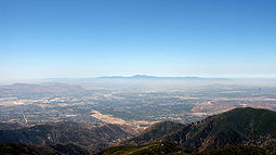
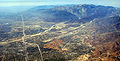
San Bernardino Valley
Encyclopedia
Valley
In geology, a valley or dale is a depression with predominant extent in one direction. A very deep river valley may be called a canyon or gorge.The terms U-shaped and V-shaped are descriptive terms of geography to characterize the form of valleys...
in Southern California
Southern California
Southern California is a megaregion, or megapolitan area, in the southern area of the U.S. state of California. Large urban areas include Greater Los Angeles and Greater San Diego. The urban area stretches along the coast from Ventura through the Southland and Inland Empire to San Diego...
. It lies at the south base of the Transverse Ranges
Transverse Ranges
The Transverse Ranges are a group of mountain ranges of southern California, in the Pacific Coast Ranges physiographic region that runs along the Pacific coast from Alaska to Mexico in North America. The Transverse Ranges begin at the southern end of the California Coast Ranges and lie between...
. It is bordered on the north by the eastern San Gabriel Mountains
San Gabriel Mountains
The San Gabriel Mountains Range is located in northern Los Angeles County and western San Bernardino County, California, United States. The mountain range lies between the Los Angeles Basin and the Mojave Desert, with Interstate 5 to the west and Interstate 15 to the east...
and San Bernardino Mountains
San Bernardino Mountains
The San Bernardino Mountains are a short transverse mountain range north and east of San Bernardino in Southern California in the United States. The mountains run for approximately 60 miles east-west on the southern edge of the Mojave Desert in southwestern San Bernardino County, north of the...
, on the east by the San Jacinto Mountains
San Jacinto Mountains
The San Jacinto Mountains are a mountain range east of Los Angeles in southern California in the United States. The mountains are named for Saint Hyacinth . The Pacific Crest Trail runs along the spine of the range.The range extends for approximately from the San Bernardino Mountains southeast to...
, and on the south and west by the Santa Ana Mountains
Santa Ana Mountains
The Santa Ana Mountains are a short peninsular mountain range along the coast of Southern California in the United States. They extend for approximately 36 mi southeast of the Los Angeles Basin largely along the border between Orange and Riverside counties.- Geography :The range starts in the...
and Pomona Valley
Pomona Valley
The Pomona Valley, located between the San Gabriel Valley and Cucamonga Valley in Southern California, straddles the border between Los Angeles County and San Bernardino County. Back on March 1, 1893 the California Assembly voted 54-14 for a new county to form in the region, San Antonio County,...
. Elevation
Elevation
The elevation of a geographic location is its height above a fixed reference point, most commonly a reference geoid, a mathematical model of the Earth's sea level as an equipotential gravitational surface ....
varies from 180 metres (590.6 ft) on valley floors near Chino
Chino, California
Chino is a city in San Bernardino County, California, United States. It is located in the western end of the Riverside-San Bernardino Area and it is easily accessible via the Chino Valley and Pomona freeways....
, where it gradually increases to about 420 metres (1,378 ft) near San Bernardino
San Bernardino, California
San Bernardino is a city located in the Riverside-San Bernardino metropolitan area , and serves as the county seat of San Bernardino County, California, United States...
and Redlands
Redlands, California
Redlands is a city in San Bernardino County, California, United States. As of the 2010 census, the city had a population of 68,747, up from 63,591 at the 2000 census. The city is located east of downtown San Bernardino.- History :...
. The valley floor houses roughly over 80% of the over 4 million total human population in the Inland Empire
Inland Empire (California)
The Inland Empire is a region in Southern California. The region sits directly east of the Los Angeles metropolitan area. The Inland Empire most commonly is used in reference to the U.S. Census Bureau's federally-defined Riverside-San Bernardino-Ontario metropolitan area, which covers more than...
region, one of the most important industrial and residential areas of Southern California
Southern California
Southern California is a megaregion, or megapolitan area, in the southern area of the U.S. state of California. Large urban areas include Greater Los Angeles and Greater San Diego. The urban area stretches along the coast from Ventura through the Southland and Inland Empire to San Diego...
and the 13th largest metropolitan area in the United States
United States
The United States of America is a federal constitutional republic comprising fifty states and a federal district...
.
History
The San Bernardino Valley was originally inhabited by Native Americans including the SerranoSerrano (people)
The Serrano are a Native American tribe of present day California, United States. They use the autonyms of Taaqtam, meaning "people"; Maarenga'yam, "people from Morongo"; and Yuhaviatam, "people of the pines." The Serrano historically populated the San Bernardino Mountains and extended east into...
Tribe. Early settlement of the area was by Mormons
Mormons
The Mormons are a religious and cultural group related to Mormonism, a religion started by Joseph Smith during the American Second Great Awakening. A vast majority of Mormons are members of The Church of Jesus Christ of Latter-day Saints while a minority are members of other independent churches....
, who still have a sizable presence in the area.
Geography
Santa Ana River
The Santa Ana River is the largest river of Southern California in the United States. Its drainage basin spans four counties. It rises in the San Bernardino Mountains and flows past the cities of San Bernardino and Riverside, before cutting through the northern tip of the Santa Ana Mountains and...
basin that goes to the sea through Riverside
Riverside County, California
Riverside County is a county in the U.S. state of California. One of 58 California counties, it covers in the southern part of the state, and stretches from Orange County to the Colorado River, which forms the state border with Arizona. The county derives its name from the city of Riverside,...
and Orange County
Orange County, California
Orange County is a county in the U.S. state of California. Its county seat is Santa Ana. As of the 2010 census, its population was 3,010,232, up from 2,846,293 at the 2000 census, making it the third most populous county in California, behind Los Angeles County and San Diego County...
. The valley connects several open natural areas and beautiful mountain and valley vistas. The San Bernardino Valley is surrounded by preserves, national forests and open recreational areas. For this reason many residents travel through the area for a variety of outdoor sports, including skiing, hiking, biking and ballooning in the mountain resorts of Crestline
Crestline, California
Crestline is a census-designated place in the San Bernardino Mountains of San Bernardino County, California, USA. The population was 10,770 at the 2010 census, up from 10,218 at the 2000 census.-Geography:Crestline is located at ....
, Lake Arrowhead
Lake Arrowhead, California
Lake Arrowhead is an unincorporated community and a census-designated place in the San Bernardino Mountains of San Bernardino County, California, within the San Bernardino National Forest, adjacent to Lake Arrowhead Reservoir...
and Big Bear City
Big Bear City, California
Big Bear City is an unincorporated, census-designated place in San Bernardino County, California immediately east of Big Bear Lake. The population was 12,304 at the 2010 census, up from 5,779 at the 2000 census...
.
Once part of famed U.S. Route 66, it is now crossed by Interstate 15 on its way through the high desert
High Desert (California)
The High Desert is an unofficial and vaguely-defined geographic area of southern California located to the northeast of the San Gabriel Mountains. The term "High Desert" is used most commonly by the news media, especially in weather forecasts, and in the names of businesses and organizations...
. Interstate 10 enters the valley from Pomona
Pomona, California
-2010:The 2010 United States Census reported that Pomona had a population of 149,058, a slight decline from the 2000 census population. The population density was 6,491.2 people per square mile...
and exits to the east over the San Gorgonio Pass
San Gorgonio Pass
The San Gorgonio Pass el. cuts between the San Bernardino Mountains on the north and the San Jacinto Mountains to the south. Like the Cajon Pass to the northwest, it was also created by the San Andreas Fault...
, which enters into the low desert
Low Desert
The Low Desert is a common name for one the Deserts of California regional areas, that includes the Colorado Desert and Yuha Desert in the Southern California portion of the Sonoran Desert...
.
Joan Didion
Joan Didion
Joan Didion is an American author best known for her novels and her literary journalism. Her novels and essays explore the disintegration of American morals and cultural chaos, where the overriding theme is individual and social fragmentation...
, in her essay "Some Dreamers of the Golden Dream," describes the San Bernardino Valley as "...in certain ways an alien place: not the coastal California of the subtropical twilights and the soft westerlies of the Pacific but a harsher California, haunted by the Mojave just beyond the mountains, devastated by the hot dry Santa Ana wind that comes down through the passes at 100 miles an hour and works on the nerves."
Geology
The San Bernardino Valley encompasses one of two drainage basinDrainage basin
A drainage basin is an extent or an area of land where surface water from rain and melting snow or ice converges to a single point, usually the exit of the basin, where the waters join another waterbody, such as a river, lake, reservoir, estuary, wetland, sea, or ocean...
s of the Santa Ana River
Santa Ana River
The Santa Ana River is the largest river of Southern California in the United States. Its drainage basin spans four counties. It rises in the San Bernardino Mountains and flows past the cities of San Bernardino and Riverside, before cutting through the northern tip of the Santa Ana Mountains and...
, the Inland Santa Ana Basin. Underneath the surface area of this drainage basin, which takes excess rain water out of the valley, are several large ground water sub-basins, which capture water in aquifer
Aquifer
An aquifer is a wet underground layer of water-bearing permeable rock or unconsolidated materials from which groundwater can be usefully extracted using a water well. The study of water flow in aquifers and the characterization of aquifers is called hydrogeology...
s underground. Designated ground water sub-basins include: Chino, Rialto-Colton, Riverside-Arlington, San Bernardino (Bunker Hill), Yucaipa and San Timoteo. The San Bernardino or Bunker Hill basin is bounded on the northeast by the San Bernardino Mountains
San Bernardino Mountains
The San Bernardino Mountains are a short transverse mountain range north and east of San Bernardino in Southern California in the United States. The mountains run for approximately 60 miles east-west on the southern edge of the Mojave Desert in southwestern San Bernardino County, north of the...
, northwest by the San Gabriel Mountains
San Gabriel Mountains
The San Gabriel Mountains Range is located in northern Los Angeles County and western San Bernardino County, California, United States. The mountain range lies between the Los Angeles Basin and the Mojave Desert, with Interstate 5 to the west and Interstate 15 to the east...
, southwest by the San Timoteo badlands
San Timoteo Canyon
San Timoteo Canyon is an ancient river valley that runs from south of Banning, California in Riverside County to a point just south of San Bernardino, California in San Bernardino County...
, and southeast by the Crafton Hills
Crafton Hills
The Crafton Hills are a mountain range in San Bernardino County, California.They are near Yucaipa, California....
.
Also, the San Andreas
San Andreas Fault
The San Andreas Fault is a continental strike-slip fault that runs a length of roughly through California in the United States. The fault's motion is right-lateral strike-slip...
and San Jacinto fault zones enter the valley along the San Bernardino Mountains and San Jacinto Mountains, respectively. The two fault lines converge to less than 10 km apart in the city of San Bernardino, and less than 3 km in the northwestern part of the basin near the Cajon Pass
Cajon Pass
Cajon Pass is a moderate-elevation mountain pass between the San Bernardino Mountains and the San Gabriel Mountains in Southern California in the United States. It was created by the movements of the San Andreas Fault...
.
Cities and communities
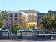
Ontario and San Bernardino both serve as the economic engines of the Greater San Bernardino area with San Bernardino having the regions major downtownDowntown San Bernardino
Downtown San Bernardino is a district in San Bernardino, California, United States. It is home to city and county government buildings, as well as the city's central business district...
core. The county and region offices are located in San Bernardino.
Principal city
- San BernardinoSan Bernardino, CaliforniaSan Bernardino is a city located in the Riverside-San Bernardino metropolitan area , and serves as the county seat of San Bernardino County, California, United States...
- Arrowhead Springs, San Bernardino
- Downtown San BernardinoDowntown San BernardinoDowntown San Bernardino is a district in San Bernardino, California, United States. It is home to city and county government buildings, as well as the city's central business district...
- University District, San BernardinoUniversity District, San BernardinoThe University District, often referred to as University Parkway, is located approximately 5–8 miles north of downtown San Bernardino, California. The District is named after the California State University, San Bernardino. It is one of the most desirable neighborhoods in San Bernardino along with...
- Devore, San Bernardino
- Muscoy, San Bernardino
Suburbs
- ColtonColton, CaliforniaColton is a city in San Bernardino County, California, United States. The city is located in the Inland Empire region of the state and is approximately 57 miles east of Los Angeles. The population of Colton is 52,154 according to the 2010 census, up from 47,662 at the 2000 census.Colton is the...
- CalimesaCalimesa, CaliforniaCalimesa is a city in Riverside County, California, United States in the Greater Los Angeles area. The population was 7,879 at the 2010 census, up from 7,139 at the 2000 census. It is situated on the San Gorgonio Pass.-Incorporation:...
- FontanaFontana, CaliforniaFontana is a city of 196,069 residents in San Bernardino County, California. Founded in 1913, it remained essentially rural until World War II, when entrepreneur Henry J. Kaiser built a large steel mill in the area...
- Grand TerraceGrand Terrace, CaliforniaGrand Terrace is a city in San Bernardino County, California, United States. The population was 12,040 at the 2010 census, up from 11,626 at the 2000 census. Grand Terrace is located between the cities of Riverside and San Bernardino along the I-215 corridor...
- HighlandHighland, CaliforniaHighland is a city in San Bernardino County, California, United States. The population in 2010 was 53,104, up from 44,605 at the 2000 census...
- Loma LindaLoma Linda, CaliforniaLoma Linda is a city in San Bernardino County, California, United States, that was incorporated in 1970. The population was 23,261 at the 2010 census, up from 18,681 at the 2000 census...
- Oak Glen
- OntarioOntario, CaliforniaOntario is a city located in San Bernardino County, California, United States, 35 miles east of downtown Los Angeles. Located in the western part of the Inland Empire region, it lies just east of the Los Angeles county line and is part of the Greater Los Angeles Area...
- Rancho CucamongaRancho Cucamonga, CaliforniaRancho Cucamonga is a suburban city in San Bernardino County, California. As of the 2010 census, the city had a population of 165,269, up from 127,743 at the 2000 census. L. Dennis Michael was elected as Mayor on November 2, 2010. Jack Lam is the City Manager...
- RedlandsRedlands, CaliforniaRedlands is a city in San Bernardino County, California, United States. As of the 2010 census, the city had a population of 68,747, up from 63,591 at the 2000 census. The city is located east of downtown San Bernardino.- History :...
- RialtoRialto, California-2010:The 2010 United States Census reported that Rialto had a population of 99,171. The population density was 4,434.1 people per square mile . The racial makeup of Rialto was 43,592 White, 16,236 African American, 1,062 Native American, 2,258 Asian, 361 Pacific Islander, 30,993 from other...
- YucaipaYucaipa, CaliforniaYucaipa is a city located east of San Bernardino, in San Bernardino County, California, United States. The population was 51,367 at the 2010 census, up from 41,207 at the 2000 census...
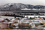
Climate
Mediterranean climate
A Mediterranean climate is the climate typical of most of the lands in the Mediterranean Basin, and is a particular variety of subtropical climate...
with cool to cold, wet, in some cases snowy winters (extreme east and north valley areas) and dry, hot summers. Usually the areas north of interstate 210 and east of interstate 215 see colder weather in the winter with occasional snowfall. Sage scrub
Artemisia californica
Artemisia californica, also known as California sagebrush, of the Asteraceae family, is a shrub that grows in coastal sage scrub, coastal strand, chaparral, and dry foothill communities, from sea level to 800 m...
and the Yucca
Yucca
Yucca is a genus of perennial shrubs and trees in the family Asparagaceae, subfamily Agavoideae. Its 40-50 species are notable for their rosettes of evergreen, tough, sword-shaped leaves and large terminal panicles of white or whitish flowers. They are native to the hot and dry parts of North...
plant are the predominant natural vegetation along washes and uplands; it intergrades with chaparral
Chaparral
Chaparral is a shrubland or heathland plant community found primarily in the U.S. state of California and in the northern portion of the Baja California peninsula, Mexico...
at elevations of
600 to 700 m. Other vegetation consists of a patchwork of grassland
Grassland
Grasslands are areas where the vegetation is dominated by grasses and other herbaceous plants . However, sedge and rush families can also be found. Grasslands occur naturally on all continents except Antarctica...
s, riparian woodlands, and mixed hardwood forest
Mediterranean forests, woodlands, and scrub
Mediterranean forests, woodlands, and scrub biome, defined by the World Wildlife Fund, characterized by dry summers and rainy winters. Summers are typically hot in low-lying inland locations but can be cool near some seas, as near San Francisco, which have a sea of cool waters...
s, which border the valley in the mountains on the north and east. The Santa Ana wind
Santa Ana wind
The Santa Ana winds are strong, extremely dry offshore winds that characteristically sweep through Southern California and northern Baja California in late fall and winter. They can range from hot to cold, depending on the prevailing temperatures in the source regions, the Great Basin and upper...
s blow into the valley from the Cajon Pass
Cajon Pass
Cajon Pass is a moderate-elevation mountain pass between the San Bernardino Mountains and the San Gabriel Mountains in Southern California in the United States. It was created by the movements of the San Andreas Fault...
, which exits the valley's north end between the San Gabriel and San Bernardino mountains.
The seasonal Santa Ana wind
Santa Ana wind
The Santa Ana winds are strong, extremely dry offshore winds that characteristically sweep through Southern California and northern Baja California in late fall and winter. They can range from hot to cold, depending on the prevailing temperatures in the source regions, the Great Basin and upper...
s are felt particularly strongly in the San Bernardino area as warm and dry air is channeled through nearby Cajon Pass
Cajon Pass
Cajon Pass is a moderate-elevation mountain pass between the San Bernardino Mountains and the San Gabriel Mountains in Southern California in the United States. It was created by the movements of the San Andreas Fault...
at times during the autumn months. This phenomenon markedly increases the wildfire danger in the foothill, canyon, and mountain communities that the cycle of cold wet winters and dry summers helps create.
| Monthly Normal High and Low Temperatures for San Bernardino | |||||||||||||
| Month | Jan | Feb | Mar | Apr | May | Jun | Jul | Aug | Sep | Oct | Nov | Dec | Year |
|---|---|---|---|---|---|---|---|---|---|---|---|---|---|
| Avg high °F | 62 | 66 | 68 | 71 | 77 | 91 | 102 | 103 | 89 | 80 | 71 | 64 | 75 |
| Avg low °F | 34 | 35 | 41 | 46 | 50 | 53 | 60 | 60 | 57 | 50 | 42 | 37 | 46 |
Local attractions
The Route 66 Rendezvous in downtown San BernardinoDowntown San Bernardino
Downtown San Bernardino is a district in San Bernardino, California, United States. It is home to city and county government buildings, as well as the city's central business district...
attracts about half a million people annually from all over the world to watch California's largest classical car show. Although not in the valley, the San Bernardino Mountains
San Bernardino Mountains
The San Bernardino Mountains are a short transverse mountain range north and east of San Bernardino in Southern California in the United States. The mountains run for approximately 60 miles east-west on the southern edge of the Mojave Desert in southwestern San Bernardino County, north of the...
attract much tourism to the valley as people drive up to the local resorts, especially in the winter months. A famous ski resort in the area is Big Bear
Big Bear
Big Bear or Mistahi-maskwa was a Cree leader notable for his involvement in the North-West Rebellion and his subsequent imprisonment.-Early life and leadership:...
. Other famous mountain communities with large tourism include Lake Arrowhead
Lake Arrowhead
-United States:Bodies of water* Arrowhead Lake * Lake Arrowhead Reservoir* Lake Arrowhead * Lake Arrowhead * Lake Arrowhead * Arrowhead Lake in Sanders County, MontanaCommunities* Lake Arrowhead, California...
, Big Bear Lake
Big Bear Lake
Big Bear Lake is a reservoir in the San Bernardino Mountains, in San Bernardino County, California, United States. At a surface elevation of , it has an east-west length of approximately 7 miles and is approximately 2.5 miles at its widest measurement, though the lake's width mostly averages a...
, and Crestline
Crestline
Crestline is the name of several places in the United States of America:* Crestline, California* Crestline, Ohio* Crestline, Kansas* Crestline, a village in Mountain Brook, Alabama...
.
National forests
United States National Forest
National Forest is a classification of federal lands in the United States.National Forests are largely forest and woodland areas owned by the federal government and managed by the United States Forest Service, part of the United States Department of Agriculture. Land management of these areas...
surrounding the high valley include the Cleveland National Forest
Cleveland National Forest
Cleveland National Forest encompasses 460,000 acres , mostly of chaparral, with a few riparian areas. A warm dry mediterranean climate prevails over the Forest. It is the southernmost National forest of California. It is administered by the United States Forest Service, a government agency within...
and the San Bernardino National Forest
San Bernardino National Forest
San Bernardino National Forest is a federally-managed forest covering more than 800,000 acres . There are two main divisions which are the San Bernardino Mountains on the easternmost of the Transverse Range, and the San Jacinto and Santa Rosa Mountains on the northernmost of the Peninsular...
.
Sports
California State University, San Bernardino
California State University, San Bernardino, also known as Cal State San Bernardino or CSUSB is a public research university and one of the twenty three general campuses of the California State University system. The main campus sits on in the suburban University District of , United States, with...
Coyotes compete at the NCAA Division II level in a variety of sports. In 2007, the Coyotes' men's basketball team competed in the Division II Final Four in Springfield, Massachusetts
Springfield, Massachusetts
Springfield is the most populous city in Western New England, and the seat of Hampden County, Massachusetts, United States. Springfield sits on the eastern bank of the Connecticut River near its confluence with three rivers; the western Westfield River, the eastern Chicopee River, and the eastern...
. However, only San Bernardino Valley College
San Bernardino Valley College
San Bernardino Valley College is a community college located in San Bernardino, California. It is fully accredited by the Western Association of Schools and Colleges. The two-year college has an enrollment of approximately 25,000 students and covers...
plays football at the collegiate level.
San Bernardino also hosts the BSR West Super Late Model Series at Orange Show Speedway. The series fields many drivers, including NASCAR
NASCAR
The National Association for Stock Car Auto Racing is a family-owned and -operated business venture that sanctions and governs multiple auto racing sports events. It was founded by Bill France Sr. in 1947–48. As of 2009, the CEO for the company is Brian France, grandson of the late Bill France Sr...
Camping World Truck Series regular Ron Hornaday
Ron Hornaday
Ronald Hornaday, Jr. is a NASCAR Camping World Truck Series driver. He is the father of former NASCAR driver Ronnie Hornaday, and son of the late Ron Hornaday, Sr., a two-time Winston West Champion. Adding on to the family legacy, Ron is a four-time champion in the Truck Series, his most recent...
, who drove the #33 in a race on July 12, 2008.
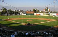
Inland Empire 66ers
San Bernardino city hosts the Inland Empire 66ers of San BernardinoInland Empire 66ers of San Bernardino
The Inland Empire 66ers of San Bernardino are a minor league baseball team in San Bernardino, California, United States. They are the Class A – Advanced affiliate of the Los Angeles Angels of Anaheim and play in the California League...
baseball club of the California League
California League
The California League is a Class A Advanced minor league baseball league which operates throughout the state of California. Before 2002, it was classified as a "High-A" league, indicating its status as a Class A league with the highest level of competition within that classification, and the fifth...
. The 66ers play at Arrowhead Credit Union Park
Arrowhead Credit Union Park
Arrowhead Credit Union Park is a stadium in San Bernardino, California, United States. Located adjacent to Downtown San Bernardino. Arrowhead Credit Union Park has been the home ballpark to the Inland Empire 66ers of San Bernardino minor league baseball team since when it was originally built in 1996...
in downtown San Bernardino
Downtown San Bernardino
Downtown San Bernardino is a district in San Bernardino, California, United States. It is home to city and county government buildings, as well as the city's central business district...
.
Rancho Cucamonga Quakes
The Rancho Cucamonga QuakesRancho Cucamonga Quakes
The Rancho Cucamonga Quakes are a minor league baseball team in Rancho Cucamonga, California, USA. They are a Class A – Advanced team in the California League and a farm team of the Los Angeles Dodgers, their third major league affiliate in team history....
are a minor league baseball team in Rancho Cucamonga
Rancho Cucamonga, California
Rancho Cucamonga is a suburban city in San Bernardino County, California. As of the 2010 census, the city had a population of 165,269, up from 127,743 at the 2000 census. L. Dennis Michael was elected as Mayor on November 2, 2010. Jack Lam is the City Manager...
. They are a "high-A" class team in the California League, and have been a farm team of the Los Angeles Angels of Anaheim since 2001, when they switched affiliations with the Lake Elsinore Storm. They were affiliated with the San Diego Padres during the late 1990s. The RC Quakes play at the Rancho Cucamonga Epic Center.
Little League baseball
San Bernardino is also the home of Al Houghton Stadium and the Western Regional Little League headquarters of Little LeagueLittle League
Little League Baseball and Softball is a non-profit organization in South Williamsport, Pennsylvania, United States which organizes local youth baseball and softball leagues throughout the U.S...
Inc. Each year in the first two weeks of August, San Bernardino hosts eleven western states in the West and Northwest regional tournaments.
Auto Club Speedway
Auto Club Speedway, a racetrack located in the city of FontanaFontana, California
Fontana is a city of 196,069 residents in San Bernardino County, California. Founded in 1913, it remained essentially rural until World War II, when entrepreneur Henry J. Kaiser built a large steel mill in the area...
, plays host to two NASCAR Sprint Cup events a year and various smaller races. It was built on the former site of the Kaiser Steel
Kaiser Steel
Kaiser Ventures is an American corporation, headquartered in Ontario, California. It was founded by Henry J. Kaiser to provide steel plate for the Pacific Coast shipbuilding industry, which expanded during World War II, then shrank, then expanded again during the Korean War...
mill.
Education
The Greater San Bernardino area is home to several cities. Some of which have their own school districts while others contract with neighboring cities to provide schooling. Notable ones would be the award winning Redlands Unified School DistrictRedlands Unified School District
The Redlands Unified School District serves the city of Redlands, California and the surrounding communities of Mentone, Forest Falls, Loma Linda, and the eastern half of Highland, in San Bernardino County. Total enrollment is 21,170. The district has 15 elementary schools that serve kindergarten...
and largest school district in the area, the San Bernardino City Unified School District
San Bernardino City Unified School District
San Bernardino City Unified School District, in San Bernardino County, California, serves most of the city of San Bernardino and a portion of Highland...
. The Valley is also home to one campus of the California State University
California State University
The California State University is a public university system in the state of California. It is one of three public higher education systems in the state, the other two being the University of California system and the California Community College system. It is incorporated as The Trustees of the...
system as well as three community colleges. In addition, some private institutions are located in the Valley as well as various trade and technical schools.
School Districts
- Colton Joint Unified School DistrictColton Joint Unified School DistrictThe Colton Joint Unified School District in San Bernardino County, California serves the communities of Colton, Bloomington, and Grand Terrace, as well as portions of Fontana, Loma Linda and unincorporated Riverside County.-High schools:...
- Fontana Unified School DistrictFontana Unified School DistrictFontana Unified School District is located in and serves most of the city of Fontana, California, a community in San Bernardino County about 50 miles east of Los Angeles. The district contains 45 schools, which serve students from K-12 to adult education. It was established in the 1920s and unified...
- Rialto Unified School DistrictRialto Unified School DistrictRialto Unified School District is a school district in Rialto, California. The Superintendent is Harold L. Cebrun. The president of the board of education is Joanne T. Gilbert....
- Redlands Unified School DistrictRedlands Unified School DistrictThe Redlands Unified School District serves the city of Redlands, California and the surrounding communities of Mentone, Forest Falls, Loma Linda, and the eastern half of Highland, in San Bernardino County. Total enrollment is 21,170. The district has 15 elementary schools that serve kindergarten...
- San Bernardino City Unified School DistrictSan Bernardino City Unified School DistrictSan Bernardino City Unified School District, in San Bernardino County, California, serves most of the city of San Bernardino and a portion of Highland...
- Yucaipa-Calimesa Joint Unified School DistrictYucaipa-Calimesa Joint Unified School DistrictYucaipa-Calimesa Joint Unified School District is a school district serving Yucaipa and Calimesa , in California, United States....
Community Colleges
- Chaffey CollegeChaffey CollegeChaffey College is a public community college in the San Bernardino County city of Rancho Cucamonga, California, in the northern part of the community of Alta Loma. Chaffey provides students with different classes and programs, including business, science, the arts, history, philosophy,...
- Crafton Hills CollegeCrafton Hills CollegeLocated in the city of Yucaipa, east of San Bernardino, Crafton Hills College serves more than 5,000 students each semester.Mission Statement-...
- San Bernardino Valley CollegeSan Bernardino Valley CollegeSan Bernardino Valley College is a community college located in San Bernardino, California. It is fully accredited by the Western Association of Schools and Colleges. The two-year college has an enrollment of approximately 25,000 students and covers...
Universities
- California State University, San BernardinoCalifornia State University, San BernardinoCalifornia State University, San Bernardino, also known as Cal State San Bernardino or CSUSB is a public research university and one of the twenty three general campuses of the California State University system. The main campus sits on in the suburban University District of , United States, with...
- Loma Linda UniversityLoma Linda UniversityLoma Linda University is a Seventh-day Adventist coeducational health sciences university located in Loma Linda, California, United States. The University comprises eight schools and the Faculty of Graduate Studies...
- University of RedlandsUniversity of RedlandsThe University of Redlands is a private liberal arts and sciences university located in Redlands, California. The university's campus sits on near downtown Redlands. The university was founded in 1907 and was associated with the American Baptist Church. The land for the university was donated by...
- American Sports UniversityAmerican Sports UniversityAmerican Sports University is a private, non-profit sports business university in San Bernardino, California, currently seeking accreditation. It has been granted permanent approval to operate from the Bureau for Private Postsecondary and Vocational Education of the State of...
Transportation
Interstate Highway System
The Dwight D. Eisenhower National System of Interstate and Defense Highways, , is a network of limited-access roads including freeways, highways, and expressways forming part of the National Highway System of the United States of America...
and their auxiliaries. Additionally, the communities in the mountains north of the valley are served by several state highways. Mass transit trains and buses both serve the valley. And goods and people movement by air is available via two commercial international airports as well as several general aviation air fields. The Greater San Bernardino Area along with the rest of the Inland Empire, is rank by Forbes Magazine as one of the American's unhealthiest communtes.
Highways
Interstate Highways.svg.png) San Bernardino FreewaySan Bernardino FreewayThe San Bernardino Freeway, formerly known as the Ramona Freeway is a freeway in Los Angeles and Orange Counties in the southern part of the U.S. state of California. It refers to the following two segments:...
San Bernardino FreewaySan Bernardino FreewayThe San Bernardino Freeway, formerly known as the Ramona Freeway is a freeway in Los Angeles and Orange Counties in the southern part of the U.S. state of California. It refers to the following two segments:...
(Interstate 10).svg.png) Interstate 15
Interstate 15.svg.png) Foothill Freeway (Interstate 210Interstate 210 (California)Interstate 210 and State Route 210 together form a contiguous highway, called the Foothill Freeway, in the Greater Los Angeles area of the U.S. state of California. The western portion of the route is an auxiliary Interstate Highway, while the eastern portion is a state highway...
Foothill Freeway (Interstate 210Interstate 210 (California)Interstate 210 and State Route 210 together form a contiguous highway, called the Foothill Freeway, in the Greater Los Angeles area of the U.S. state of California. The western portion of the route is an auxiliary Interstate Highway, while the eastern portion is a state highway...
).svg.png) Interstate 215Interstate 215 (California)Interstate 215 is a long north–south Interstate highway in the Inland Empire region of Southern California. It is an auxiliary route of Interstate 15 , running from Murrieta to northern San Bernardino...
Interstate 215Interstate 215 (California)Interstate 215 is a long north–south Interstate highway in the Inland Empire region of Southern California. It is an auxiliary route of Interstate 15 , running from Murrieta to northern San Bernardino...
State Highways
 State Route 18
 State Route 38California State Route 38State Route 38 is a mostly rural and scenic road in the U.S. state of California. Despite the orientation of its alignment, SR 38 is assigned in a west–east direction.-Route description:...
 State Route 66
 State Route 138California State Route 138State Route 138 is an east–west state highway generally following the northern foothills of the San Gabriel Mountains of southern California, USA from its junction with Interstate 5 south of Gorman eastward to Mount Anderson Junction, its eastern junction with State Route 18 south of...
 State Route 210 (formerly
  State Route 30)
 State Route 330California State Route 330State Route 330 is a state highway in the U.S. state of California. It is also known as City Creek Road in the San Bernardino Mountains.-Route description:...
Mass transportation
Although high percentage of valley residents drive their own cars, there are several available options for mass transit. The largest bus line in the Greater San Bernardino area is OmnitransOmnitrans
Omnitrans is a public transportation agency in San Bernardino County, California, United States. The largest transit operator within San Bernardino County, it serves the San Bernardino Valley. The agency was established in 1976 through a joint powers agreement and today includes 15 cities and...
, which covers virtually the entire valley. The Omni lines also meet lines for Foothill Transit
Foothill Transit
Foothill Transit is a joint powers authority of 21 member cities in the San Gabriel and Pomona Valleys. It operates a fixed-route bus public transit service in the San Gabriel Valley of Greater Los Angeles, California.-Overview:...
and Riverside Transit Agency
Riverside Transit Agency
Riverside Transit Agency is a joint powers agency that provides public transportation in western Riverside County, California, United States. It operates more than 300 vehicles on 36 local fixed routes, eight long-distance "CommuterLink" express bus routes, and Dial-A-Ride service. RTA was...
buses, providing connectivity to Riverside County and Los Angeles County. The area is also served by Metrolink
Metrolink (Southern California)
Metrolink is a commuter rail system serving Los Angeles and the surrounding area of Southern California; it currently consists of six lines and 55 stations using of track....
's San Bernardino Line and the IEOC Line. These lines lead to the Los Angeles Metropolitan and San Diego Metropolitan areas.
Railroad
The two main railroads in the valley are Union Pacific (UP) and BNSF. Both have extensive yards in the valley and it is an important area for national movement of goods. UP tracks enter the valley from the south alongside the BNSF tracks in Colton/Grand Terrace. They then continue north until the Colton CrossingColton Crossing
The Colton Crossing is an "at grade" Railway Crossing situated in Colton, California, directly south of the Interstate 10 freeway. First built in 1883, it was the site of one of the most intense Frog wars in railroad construction history leading to a personal confrontation between famed lawman...
, where they then turn east. Union Pacific also has a second set of tracks that were the Southern Pacific tracks until they took over SP. These tracks enter the valley from the west through Ontario, passing alongside the 10
Interstate 10
Interstate 10 is the fourth-longest Interstate Highway in the United States, after I-90, I-80, and I-40. It is the southernmost east–west, coast-to-coast Interstate Highway, although I-4 and I-8 are further south. It stretches from the Pacific Ocean at State Route 1 in Santa Monica,...
until Loma Linda, where they turn and exit the valley to the southeast. The BNSF track enters the valley from the south by Colton/Grand Terrace as well, but continues north at the Colton Crossing. It then enters the intermodal and car transfer yards, where it turns east for approximately a mile. It then turns north again, running alongside I-215 until it meets the 15 in Devore and exits the valley via the Cajon Pass. Union Pacific also has a line that exits the valley through the pass. The Colton Crossing, located in Colton, is the point where the tracks of the two companies cross.
Airports
| Airport Airport An airport is a location where aircraft such as fixed-wing aircraft, helicopters, and blimps take off and land. Aircraft may be stored or maintained at an airport... |
IATA code IATA airport code An IATA airport code, also known an IATA location identifier, IATA station code or simply a location identifier, is a three-letter code designating many airports around the world, defined by the International Air Transport Association... |
ICAO code ICAO airport code The ICAO airport code or location indicator is a four-character alphanumeric code designating each airport around the world. These codes are defined by the International Civil Aviation Organization, and published in ICAO Document 7910: Location Indicators.The ICAO codes are used by air traffic... |
County County (United States) In the United States, a county is a geographic subdivision of a state , usually assigned some governmental authority. The term "county" is used in 48 of the 50 states; Louisiana is divided into parishes and Alaska into boroughs. Parishes and boroughs are called "county-equivalents" by the U.S... |
|---|---|---|---|
| Ontario International Airport Ontario International Airport LA/Ontario International Airport , formerly Ontario International Airport, is a public airport located east of the central business district of Ontario, a city in San Bernardino County, California, USA. This airport is owned and operated by the Los Angeles World Airports , an agency of the city... |
ONT | KONT | San Bernardino San Bernardino County, California San Bernardino County is a county in the U.S. state of California. As of the 2010 census, the population was 2,035,210, up from 1,709,434 as of the 2000 census... |
| San Bernardino International Airport San Bernardino International Airport San Bernardino International Airport is a public airport located two miles southeast of the central business district of San Bernardino, California, in San Bernardino County, California, USA. The airport covers and has one runway. It is currently a general aviation and cargo airport located on... |
SBD | KSBD | San Bernardino San Bernardino County, California San Bernardino County is a county in the U.S. state of California. As of the 2010 census, the population was 2,035,210, up from 1,709,434 as of the 2000 census... |
See Also
- Riverside-San Bernardino Metropolitan AreaInland Empire (California)The Inland Empire is a region in Southern California. The region sits directly east of the Los Angeles metropolitan area. The Inland Empire most commonly is used in reference to the U.S. Census Bureau's federally-defined Riverside-San Bernardino-Ontario metropolitan area, which covers more than...
- Southern CaliforniaSouthern CaliforniaSouthern California is a megaregion, or megapolitan area, in the southern area of the U.S. state of California. Large urban areas include Greater Los Angeles and Greater San Diego. The urban area stretches along the coast from Ventura through the Southland and Inland Empire to San Diego...