
San Andres, Manila
Encyclopedia
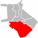
San Andrés is a district located in the south east of the City of Manila in the Philippines
, and includes what used to be the pre-World War II district of Singalong as well as parts of the Malate
, and Paco
districts. San Andrés shares its northeastern border with Santa Ana
, and Paco, while to its south lie Pasay City, and Makati City. The district is under the jurisdiction of the 5th congressional district of Manila.
. Mostly residential, the majority of the district's residents live just above the poverty line. The original inhabitants were middle or lower-class migrant families who had formerly settled in Tondo but found the rough working-class lifestyle less suitable for raising children. During World War II
, the south side of Manila was devastated and afterwards migrants from nearby provinces and the Visayas
region moved to Manila where they settled in San Andres when much of it was still open space. The flow of settlers into the district was unplanned, resulting in a lack of urban planning
as evidenced with irregular buildings, narrow roadways, and large blocks of houses accessible only through one meter wide alleyways. The only sections of the district that have any semblance of planning are those in what used to be the Singalong district. Although largely absorbed into San Andres, there is still a street called Singalong that runs parallel to the Quirino Highway.
San Andrés is divided into eastern and western sectors by the Sergio Osmeña Highway. Singalong is what used to be the western section of San Andres while the eastern parts used to be part of the territories of Paco and Santa Ana. Elderly residents of Singalong believe that its name was derived from a Tagalog
word for a cup shaped from bamboo
. During the colonial period, Spaniards
awarded the area to members of the Capuchin
Catholic missionaries who thereafter converted the native population.
San Andrés is largely a residential area with some sections classified as commercial. The district is home to two private schools, St. Scholastica's College
established by the Benedictine Sisters
in 1914, and the College of St. Benilde (DLSU) and St. Anthony School, a parochial school next to the Parish of St. Anthony de Padua.
Philippines
The Philippines , officially known as the Republic of the Philippines , is a country in Southeast Asia in the western Pacific Ocean. To its north across the Luzon Strait lies Taiwan. West across the South China Sea sits Vietnam...
, and includes what used to be the pre-World War II district of Singalong as well as parts of the Malate
Malate, Manila
Malate is an old district of the city of Manila in Metro Manila, the Philippines. The district is located at the southern end of the city of Manila, bordered by Pasay City to the south, by Manila Bay to the west, by the district of Ermita to the north and by the districts of Paco and San Andres to...
, and Paco
Paco, Manila
Paco, is a district of Manila, Philippines. It is located south of Pasig River, and San Miguel, west of Santa Ana, southwest of Pandacan, north of Malate, northwest of San Andres, and east of Ermita. According to the 2000 census, it has a population of 64,184 people in 13,438 households...
districts. San Andrés shares its northeastern border with Santa Ana
Santa Ana, Manila
Santa Ana is a district of the City of Manila in the Philippines, located at the southeast banks of the Pasig River, bounded on the northeast by Mandaluyong City, Makati City to the east, southwest is the Manila district of Paco, and to the west, Pandacan....
, and Paco, while to its south lie Pasay City, and Makati City. The district is under the jurisdiction of the 5th congressional district of Manila.
Profile
Although San Andrés only has a small land area, it is the second most densely populated district in Manila after TondoTondo, Manila
Tondo is a district of Manila, Philippines. The locale has existed prior to the arrival of the Spanish, referred to as "Tundun" in the Laguna Copperplate Inscription. One of the most densely populated areas of land in the world, Tondo is located in the northwest portion of the city and is primarily...
. Mostly residential, the majority of the district's residents live just above the poverty line. The original inhabitants were middle or lower-class migrant families who had formerly settled in Tondo but found the rough working-class lifestyle less suitable for raising children. During World War II
World War II
World War II, or the Second World War , was a global conflict lasting from 1939 to 1945, involving most of the world's nations—including all of the great powers—eventually forming two opposing military alliances: the Allies and the Axis...
, the south side of Manila was devastated and afterwards migrants from nearby provinces and the Visayas
Visayas
The Visayas or Visayan Islands and locally known as Kabisay-an gid, is one of the three principal geographical divisions of the Philippines, along with Mindanao and Luzon. It consists of several islands, primarily surrounding the Visayan Sea, although the Visayas are considered the northeast...
region moved to Manila where they settled in San Andres when much of it was still open space. The flow of settlers into the district was unplanned, resulting in a lack of urban planning
Urban planning
Urban planning incorporates areas such as economics, design, ecology, sociology, geography, law, political science, and statistics to guide and ensure the orderly development of settlements and communities....
as evidenced with irregular buildings, narrow roadways, and large blocks of houses accessible only through one meter wide alleyways. The only sections of the district that have any semblance of planning are those in what used to be the Singalong district. Although largely absorbed into San Andres, there is still a street called Singalong that runs parallel to the Quirino Highway.
San Andrés is divided into eastern and western sectors by the Sergio Osmeña Highway. Singalong is what used to be the western section of San Andres while the eastern parts used to be part of the territories of Paco and Santa Ana. Elderly residents of Singalong believe that its name was derived from a Tagalog
Tagalog language
Tagalog is an Austronesian language spoken as a first language by a third of the population of the Philippines and as a second language by most of the rest. It is the first language of the Philippine region IV and of Metro Manila...
word for a cup shaped from bamboo
Bamboo
Bamboo is a group of perennial evergreens in the true grass family Poaceae, subfamily Bambusoideae, tribe Bambuseae. Giant bamboos are the largest members of the grass family....
. During the colonial period, Spaniards
Spain
Spain , officially the Kingdom of Spain languages]] under the European Charter for Regional or Minority Languages. In each of these, Spain's official name is as follows:;;;;;;), is a country and member state of the European Union located in southwestern Europe on the Iberian Peninsula...
awarded the area to members of the Capuchin
Order of Friars Minor Capuchin
The Order of Friars Minor Capuchin is an Order of friars in the Catholic Church, among the chief offshoots of the Franciscans. The worldwide head of the Order, called the Minister General, is currently Father Mauro Jöhri.-Origins :...
Catholic missionaries who thereafter converted the native population.
San Andrés is largely a residential area with some sections classified as commercial. The district is home to two private schools, St. Scholastica's College
St. Scholastica's College
St. Scholastica's College, Manila is a Catholic institution for women established in 1906 and managed by the Missionary Benedictine Sisters of Tutzing. It is located in 3.66 hectare lot in Malate in the city of Manila. It is bounded by Estrada Street on the north, P...
established by the Benedictine Sisters
Benedictine Sisters
Benedictine Sisters may refer to any of the following Benedictine religious orders:*Benedictine Sisters of the Reparation of the Holy Face*Benedictine Sisters of Perpetual Adoration*Benedictine Sisters of Elk County...
in 1914, and the College of St. Benilde (DLSU) and St. Anthony School, a parochial school next to the Parish of St. Anthony de Padua.