

San Andreas Fault Observatory at Depth
Encyclopedia
Earthscope
EarthScope is an earth science program using geological and geophysical techniques to explore the structure and evolution of the North American continent and to understand the processes controlling earthquakes and volcanoes. Thousands of geophysical instruments will comprise a dense grid covering...
Project, funded by the National Science Foundation
National Science Foundation
The National Science Foundation is a United States government agency that supports fundamental research and education in all the non-medical fields of science and engineering. Its medical counterpart is the National Institutes of Health...
in conjunction with the USGS and NASA
NASA
The National Aeronautics and Space Administration is the agency of the United States government that is responsible for the nation's civilian space program and for aeronautics and aerospace research...
. The SAFOD site is located just north of the town of Parkfield, California
Parkfield, California
Parkfield is an unincorporated community in Monterey County, California. It is located on Little Cholame Creek east of Bradley, at an elevation of 1529 feet...
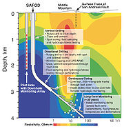
. The SAFOD main hole was drilled to a depth of ~3.4 km in 2004 and 2005, crossing the San Andreas near a region of the fault where repeating Magnitude 2 earthquakes are generated.
A goal of this project is to install instruments to record data near the source of these earthquake
Earthquake
An earthquake is the result of a sudden release of energy in the Earth's crust that creates seismic waves. The seismicity, seismism or seismic activity of an area refers to the frequency, type and size of earthquakes experienced over a period of time...
s. In addition to the installation of these instruments, rock and fluid samples were continuously collected during the drilling process, and will also be used to analyze changes in geochemistry
Geochemistry
The field of geochemistry involves study of the chemical composition of the Earth and other planets, chemical processes and reactions that govern the composition of rocks, water, and soils, and the cycles of matter and energy that transport the Earth's chemical components in time and space, and...
and mechanical properties around the fault zone. The project will lead to a better understanding of the processes that control the behavior of the San Andreas fault, and it is hoped that the development of instrumentation and analytic methods will help evaluate the possibility of earthquake prediction
Earthquake prediction
An earthquake prediction is a prediction that an earthquake of a specific magnitude will occur in a particular place at a particular time . Despite considerable research efforts by seismologists, scientifically reproducible predictions cannot yet be made to a specific day or month...
.
Drilling will be done in three phases. Drilling was started in the summer of 2004 (Phase 1), when the hole was drilled to a vertical depth 1500 m (4,921.3 ft), and then the trajectory of the hole was angled toward the fault. Drilling was resumed in summer of 2005, at which point the San Andreas was crossed at a depth of around 3 km. Phase 3 which involved the collection of 1600 m (5,249.3 ft) of core from active areas of the fault was completed on 15 September, 2007. Following the completion of phase 3, instruments have been placed in the hole to monitor the long-term behavior of the fault.
The SAFOD observatory is presently in operation. All data collected at SAFOD as part of the EarthScope project are open and freely available to all interested researchers. The Northern California Earthquake Data Center at U.C. Berkeley is the principal data repository for these SAFOD data. Several terabyte of assembled data collection are also available at the IRIS DMC
IRIS Consortium
IRIS is a university research consortium dedicated to exploring the Earth's interior through the collection and distribution of seismographic data. IRIS programs contribute to scholarly research, education, earthquake hazard mitigation, and the verification of a Comprehensive Test Ban Treaty...
.
See also
- Chikyu HakkenChikyu Hakkenis a Japanese scientific drilling ship built for the Integrated Ocean Drilling Program . The vessel is designed to ultimately drill seven kilometres beneath the seabed, where the Earth's crust is much thinner, and into the Earth's mantle, deeper than any other hole drilled in the ocean thus...
, deep oceanic drilling program - EarthscopeEarthscopeEarthScope is an earth science program using geological and geophysical techniques to explore the structure and evolution of the North American continent and to understand the processes controlling earthquakes and volcanoes. Thousands of geophysical instruments will comprise a dense grid covering...
- Integrated Ocean Drilling ProgramIntegrated Ocean Drilling ProgramThe Integrated Ocean Drilling Program is an international marine research program. The program uses heavy drilling equipment mounted aboard ships to monitor and sample sub-seafloor environments...
- Kola Superdeep BoreholeKola Superdeep BoreholeThe Kola Superdeep Borehole is the result of a scientific drilling project of the Soviet Union in Kola Peninsula. The project attempted to drill as deep as possible into the Earth's crust. Drilling began on 24 May 1970 using the Uralmash-4E, and later the Uralmash-15000 series drilling rig. A...
- Mohorovičić discontinuityMohorovičić discontinuityThe Mohorovičić discontinuity , usually referred to as the Moho, is the boundary between the Earth's crust and the mantle. Named after the pioneering Croatian seismologist Andrija Mohorovičić, the Moho separates both the oceanic crust and continental crust from underlying mantle...
- Project MoholeProject MoholeProject Mohole was an ambitious attempt to drill through the Earth's crust into the Mohorovičić discontinuity, and to provide an Earth science complement to the high profile Space Race. The project was initially led by the American Miscellaneous Society with funding from the National Science...
- USARRAYUSARRAYUSArray is one of the three components of the Earthscope project, funded by the National Science Foundation and being constructed, operated, and maintained as a collaborative effort with UNAVCO Inc., the Incorporated Research Institutions for Seismology, and Stanford University, with contributions...