

Samoan Islands
Encyclopedia
The Samoan Islands or Samoa Islands is an archipelago
covering 3030 km² (1,170 sq mi) in the central South Pacific
, forming part of Polynesia
and the wider region of Oceania
. The population of the Samoan Islands is approximately 250,000, sharing a common language, Samoan
, a culture, known as fa'a Samoa
and an indigenous form of governance called fa'amatai
.
Due to colonialism
, the Samoa Islands and people were divided by Western powers. Today, the islands have two jurisdictions, the independent country of Samoa
in the western half of the islands, and the territory of American Samoa
comprising the islands to the east. The two regions are separated by 64 km of ocean. Most Samoans are full-blooded and are one of the largest Polynesian
populations in the world.
The oldest date so far from prehistoric remains in the Samoan Islands has been calculated from archaeology in Samoa
to a likely true age of circa 3,000 BP (before present, where present is AD 1950) from a Lapita
site at Mulifanua
wharf on Upolu
island.
In 1768, the eastern islands were visited by French explorer Bougainville
, who named them the Navigator Islands, a name used by missionaries until about 1845 and in official European dispatches until about 1870.
the two jurisdictions of the Samoa Islands are;, independent nation, situated at the western half of the islands, gained political independence in 1962 (2,831 km² and 185,000 inhabitants). Formerly known as German Samoa
(1900–1914) and Western Samoa (up to 1997).
, an unincorporated territory of the United States
consisting of the islands to the east (199 square kilometers and 65,000 inhabitants).
, Germany
and the United Kingdom
resulted in the Tripartite Convention (1899) that formally partitioned the Samoan archipelago into a German colony (German Samoa
) and a United States territory (American Samoa). The international convention occurred on the brink of World War I
. Forerunners to the Tripartite Convention of 1899 were the Washington Conference of 1887, the Treaty of Berlin of 1889
and the Anglo-German Agreement on Samoa of 1899. New Zealand
occupied the German colony through 1920, then governed the western islands until independence in 1962 as a (1) League of Nations
Class C Mandate and (2) United Nations Trust Territory
after 1946. The pro-independence Mau movement
across the islands eventually led to the political independence of the western islands from New Zealand in 1962 while the eastern islands, American Samoa, remains a political territory of the United States.
The islands of Manono, Apolima and Nu'ulopa lie in the Apolima Strait
between Upolu and Savai'i. The four small uninhabited islands Nu'utele, Nu'ulua, Namua and Fanuatapu are situated off the east coast of Upolu and comprise the Aleipata Islands
.
, 530 km (329.3 mi) from Tonga
, 2900 km (1,802 mi) from New Zealand
, and 4000 km (2,485.5 mi) from Hawaii
, U.S.A.
The islands lies between 13° and 14° south latitude and 169° and 173° west longitude, about 480 km (298.3 mi) from west to east.
The larger islands are volcanic in origin, mountainous, and covered in tropical moist forest. Some of the smaller islands are coral atolls with black sand beaches.
, on the island of Savai'i
, one of the highest peaks in Polynesia at 1858 m. The highest point in American Samoa is on Ta’u
, Lata Mountain, at 966 m (3,169.3 ft).
and Savai'i
in Samoa, are among the largest of Polynesian islands, at 1718 km² (663.3 sq mi) and 1125 km² (434.4 sq mi) , respectively, exceeded in size only by the two main islands of Fiji and the Hawaiian islands of Hawaiʻi
and Maui
. The island of Upolu is more populated than Savai'i.
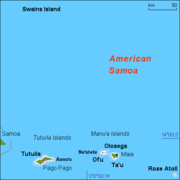
The next largest island is Tutuila
, where the city and harbor Pago Pago (population 3,519 in 1990) is located. Tutuila is much smaller than Upolu and Savai‘i at 136.2 km² (52.6 sq mi) in area, but it is the largest island in American Samoa. The highest peak on Tutuila is Matafao Peak.
Smaller islands in the archipelago include the three islets (Manono Island
, Apolima
and Nu'ulopa
) in the Apolima Strait
between Savai'i and Upolu; the four Aleipata Islands
off the eastern end of Upolu
(Nu'utele
, Nu'ulua
, Namua
, and Fanuatapu
); and Nu‘usafe‘e.
To the east of Tutuila, the Manu'a group comprises Ofu, Olosega
, Ta’u
, and Aunu'u
. An uninhabited coral atoll, Rose Atoll
, is the southernmost point in the territory of the United States. Another coral atoll, Swains Island
, is within the territory of American Samoa but is geographically distant from the Samoan archipelago.
situated at the east end of the Samoa Islands. In theory, the Samoa hotspot is a result of the Pacific Tectonic Plate
moving over a 'fixed' deep and narrow mantle plume
spewing up through the Earth's crust. The Samoa islands generally lie in a straight line, east to west, in the same direction the Plate is moving. In the classic hotspot model, primarily based on studies of the Hawaii hotspot
, the volcanic islands and seamount
s further away from the Samoa hotspot should be progressively older. However, Savai'i
, the most western of the Samoa island chain, and Ta'u Island
, the most eastern of the Samoa islands, both erupted in the last century, data which is an enigma for scientists. Another discrepancy in the data from the Samoa islands is that subaerial
rock samples from Savai'i, the most western of the islands, were too young by several million years to fit the classic hotspot model of age progression in an island chain, raising arguments among scientists that the Samoa islands does not have a plume origin. The nearness of the island chain to the Tonga Trench
at the south became a possible explanation for these discrepancies as well as the possibility that the islands were formed by magma
seeping through cracks in stressed fracture zones.
However, in 2005, an international team gathered further submarine samples from the deep flanks and rift
s of Savai'i. Tests on these later samples showed much older ages, about five million years old, that fit the hotspot model.
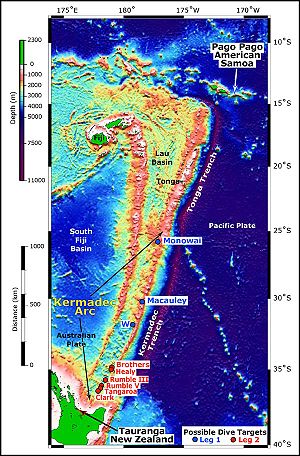 The 2009 Samoa earthquake
caused a tsunami
that killed more than 170 people in the Samoa Islands and Tonga
. The earthquake was an 8.1 Mw
submarine
earthquake
that took place in the region at 06:48:11 local time on September 29, 2009 (17:48:11 UTC
, September 29), followed by smaller aftershocks. It was the largest earthquake of 2009. The quake occurred on the outer rise
of the Kermadec-Tonga Subduction Zone
. This is part of the Pacific Ring of Fire
, where tectonic plates
in the Earth's lithosphere
meet and earthquakes and volcanic activity are common.
, an active submerged volcano, lies 45 km east of Ta'u in
American Samoa
. It was discovered in 1975 and has since been studied by an international team of scientists, contributing towards understanding of the Earth's fundamental processes. Growing inside the summit crater of Va'ilulu'u is an active underwater volcanic cone
, named after Samoa's goddess of war, Nafanua
.
Archipelago
An archipelago , sometimes called an island group, is a chain or cluster of islands. The word archipelago is derived from the Greek ἄρχι- – arkhi- and πέλαγος – pélagos through the Italian arcipelago...
covering 3030 km² (1,170 sq mi) in the central South Pacific
Pacific Ocean
The Pacific Ocean is the largest of the Earth's oceanic divisions. It extends from the Arctic in the north to the Southern Ocean in the south, bounded by Asia and Australia in the west, and the Americas in the east.At 165.2 million square kilometres in area, this largest division of the World...
, forming part of Polynesia
Polynesia
Polynesia is a subregion of Oceania, made up of over 1,000 islands scattered over the central and southern Pacific Ocean. The indigenous people who inhabit the islands of Polynesia are termed Polynesians and they share many similar traits including language, culture and beliefs...
and the wider region of Oceania
Oceania
Oceania is a region centered on the islands of the tropical Pacific Ocean. Conceptions of what constitutes Oceania range from the coral atolls and volcanic islands of the South Pacific to the entire insular region between Asia and the Americas, including Australasia and the Malay Archipelago...
. The population of the Samoan Islands is approximately 250,000, sharing a common language, Samoan
Samoan language
Samoan Samoan Samoan (Gagana Sāmoa, is the language of the Samoan Islands, comprising the independent country of Samoa and the United States territory of American Samoa. It is an official language—alongside English—in both jurisdictions. Samoan, a Polynesian language, is the first language for most...
, a culture, known as fa'a Samoa
Fa'a Samoa
Fa'a Samoa means literally The Samoan Way which describes the socio-political and cultural way of life for the people of the Samoan Islands....
and an indigenous form of governance called fa'amatai
Fa'amatai
Fa'amatai is the chiefly system of Samoa, central to the organization of Samoan society.It is the traditional indigenous form of governance in the Samoa Islands, comprising American Samoa and the Independent State of Samoa...
.
Due to colonialism
Colonialism
Colonialism is the establishment, maintenance, acquisition and expansion of colonies in one territory by people from another territory. It is a process whereby the metropole claims sovereignty over the colony and the social structure, government, and economics of the colony are changed by...
, the Samoa Islands and people were divided by Western powers. Today, the islands have two jurisdictions, the independent country of Samoa
Samoa
Samoa , officially the Independent State of Samoa, formerly known as Western Samoa is a country encompassing the western part of the Samoan Islands in the South Pacific Ocean. It became independent from New Zealand in 1962. The two main islands of Samoa are Upolu and one of the biggest islands in...
in the western half of the islands, and the territory of American Samoa
American Samoa
American Samoa is an unincorporated territory of the United States located in the South Pacific Ocean, southeast of the sovereign state of Samoa...
comprising the islands to the east. The two regions are separated by 64 km of ocean. Most Samoans are full-blooded and are one of the largest Polynesian
Polynesians
The Polynesian peoples is a grouping of various ethnic groups that speak Polynesian languages, a branch of the Oceanic languages within the Austronesian languages, and inhabit Polynesia. They number approximately 1,500,000 people...
populations in the world.
The oldest date so far from prehistoric remains in the Samoan Islands has been calculated from archaeology in Samoa
Archaeology in Samoa
Archaeology of Samoa began with the first systematic survey of archaeological remains on Savai'i island by Jack Golson in 1957. Since then, surveys and studies in the rest of Samoa have uncovered major findings of settlements, stone and earth mounds including star mounds, Lapita pottery remains and...
to a likely true age of circa 3,000 BP (before present, where present is AD 1950) from a Lapita
Lapita
Lapita is a term applied to an ancient Pacific Ocean archaeological culture which is believed by many archaeologists to be the common ancestor of several cultures in Polynesia, Micronesia, and some coastal areas of Melanesia...
site at Mulifanua
Mulifanua
Mulifanua is a village on the north-western tip of the island of Upolu, in Samoa. In the modern era, it is the capital of Aiga-i-le-Tai district...
wharf on Upolu
Upolu
Upolu is an island in Samoa, formed by a massive basaltic shield volcano which rises from the seafloor of the western Pacific Ocean. The island is long, in area, and is the second largest in geographic area as well as the most populated of the Samoan Islands. Upolu is situated to the east of...
island.
In 1768, the eastern islands were visited by French explorer Bougainville
Louis Antoine de Bougainville
Louis-Antoine, Comte de Bougainville was a French admiral and explorer. A contemporary of James Cook, he took part in the French and Indian War and the unsuccessful French attempt to defend Canada from Britain...
, who named them the Navigator Islands, a name used by missionaries until about 1845 and in official European dispatches until about 1870.
Samoa and American Samoa
PoliticallyPolitical geography
Political geography is the field of human geography that is concerned with the study of both the spatially uneven outcomes of political processes and the ways in which political processes are themselves affected by spatial structures...
the two jurisdictions of the Samoa Islands are;, independent nation, situated at the western half of the islands, gained political independence in 1962 (2,831 km² and 185,000 inhabitants). Formerly known as German Samoa
German Samoa
German Samoa was a German protectorate from 1900 to 1914, consisting of the islands of Upolu, Savai'i, Apolima and Manono, now wholly within the independent state Samoa, formerly Western Samoa...
(1900–1914) and Western Samoa (up to 1997).
-
- Capital Apia, currency Samoan talaSamoan talaThe tālā is the currency of Samoa. It is divided into 100 sene. The terms tālā and sene are the equivalents or transliteration of the English words dollar and cent, in the Samoan language....
.
- Capital Apia, currency Samoan tala
, an unincorporated territory of the United States
United States
The United States of America is a federal constitutional republic comprising fifty states and a federal district...
consisting of the islands to the east (199 square kilometers and 65,000 inhabitants).
-
- Capital Pago Pago, currency US dollar
Political partition
In the late 1800s, rivalry between the United StatesUnited States
The United States of America is a federal constitutional republic comprising fifty states and a federal district...
, Germany
German Empire
The German Empire refers to Germany during the "Second Reich" period from the unification of Germany and proclamation of Wilhelm I as German Emperor on 18 January 1871, to 1918, when it became a federal republic after defeat in World War I and the abdication of the Emperor, Wilhelm II.The German...
and the United Kingdom
United Kingdom
The United Kingdom of Great Britain and Northern IrelandIn the United Kingdom and Dependencies, other languages have been officially recognised as legitimate autochthonous languages under the European Charter for Regional or Minority Languages...
resulted in the Tripartite Convention (1899) that formally partitioned the Samoan archipelago into a German colony (German Samoa
German Samoa
German Samoa was a German protectorate from 1900 to 1914, consisting of the islands of Upolu, Savai'i, Apolima and Manono, now wholly within the independent state Samoa, formerly Western Samoa...
) and a United States territory (American Samoa). The international convention occurred on the brink of World War I
World War I
World War I , which was predominantly called the World War or the Great War from its occurrence until 1939, and the First World War or World War I thereafter, was a major war centred in Europe that began on 28 July 1914 and lasted until 11 November 1918...
. Forerunners to the Tripartite Convention of 1899 were the Washington Conference of 1887, the Treaty of Berlin of 1889
Treaty of Berlin (1889)
The Treaty of Berlin was the concluding document of the conference at Berlin in 1889 on Samoa. The conference was proposed by German foreign minister Count Herbert von Bismarck to reconvene the adjourned Washington conference on Samoa of 1887...
and the Anglo-German Agreement on Samoa of 1899. New Zealand
New Zealand
New Zealand is an island country in the south-western Pacific Ocean comprising two main landmasses and numerous smaller islands. The country is situated some east of Australia across the Tasman Sea, and roughly south of the Pacific island nations of New Caledonia, Fiji, and Tonga...
occupied the German colony through 1920, then governed the western islands until independence in 1962 as a (1) League of Nations
League of Nations
The League of Nations was an intergovernmental organization founded as a result of the Paris Peace Conference that ended the First World War. It was the first permanent international organization whose principal mission was to maintain world peace...
Class C Mandate and (2) United Nations Trust Territory
United Nations Trust Territories
United Nations trust territories were the successors of the remaining League of Nations mandates and came into being when the League of Nations ceased to exist in 1946. All of the trust territories were administered through the UN Trusteeship Council...
after 1946. The pro-independence Mau movement
Mau movement
The Mau was a non-violent movement for Samoan independence from colonial rule during the early 1900s. The word 'Mau' means 'opinion' or 'testimony' denoting 'firm strength' in Samoan...
across the islands eventually led to the political independence of the western islands from New Zealand in 1962 while the eastern islands, American Samoa, remains a political territory of the United States.
Samoa
- UpoluUpoluUpolu is an island in Samoa, formed by a massive basaltic shield volcano which rises from the seafloor of the western Pacific Ocean. The island is long, in area, and is the second largest in geographic area as well as the most populated of the Samoan Islands. Upolu is situated to the east of...
, population 134,400 (2001), most populous island in the group. - Savai'iSavai'iSavaii is the largest and highest island in Samoa and the Samoa Islands chain. It is also the biggest landmass in Polynesia outside Hawaii and New Zealand. The island of Savai'i is also referred to by Samoans as Salafai, a classical Samoan term used in oratory and prose...
, population 43,142 (2006), largest landmass and most western in the group, most recent volcanic eruptions Mt MatavanuMt MatavanuMt Matavanu is an active volcano on the island of Savai'i in Samoa.The most recent eruptions from Matavanu occurred between 1905 - 1911 with lava flows on its northern side flowing towards the island's coastline and into the sea in the district of Gaga'emauga....
(1905–1911); Mata o le Afi (1902); Mauga Afi (approximately 1725). - ManonoManono IslandManono is an island of Samoa, situated in the Apolima Strait between the main islands of Savai'i and Upolu, 3.4 km WNW off Lefatu Cape, the westernmost point of Upolu....
, population 889 (2006) - ApolimaApolimaApolima is the smallest of the four inhabited islands of Samoa and situated in the Apolima Strait, between the country's two largest islands Upolu to the east and Savai'i to the west....
, population 75 (2006) - FanuatapuFanuatapuFanuatapu is an uninhabited island which consists of a volcanic tuff ring, situated off the eastern tip of Upolu, Samoa. It is the smallest and easternmost of the four Aleipata Islands, with an area of 15 hectares, and has an automated lighthouse....
, uninhabited, volcanic tuff ring. - NamuaNamuaNamu'a is a small uninhabited island off the east coast of Upolu island in Samoa.The island is a 10 minute boat ride from Upolu and has beach fale accommodation for visitors. There are lookouts and it takes about an hour to walk around the island....
, uninhabited, has beach faleBeach faleBeach fale is a modern term for a simple thatched hut in Samoa. They are also common in other parts of Polynesia. They have become popular in tourism as low budget accommodation situated by the coast, built with a few posts, no walls and a thatched roof with a round or oval shape.The word fale is...
accommodation for visitors, viewed from LalomanuLalomanuLalomanu is a village on the east coast of Upolu island in Samoa.The village is part of the electoral constituency Aleipata Itupa i Luga which is within the larger political district of Atua....
beach. - Nu'ulopaNu'ulopaNu'ulopa is a small uninhabited island in the Apolima Strait between the islands of Upolu and Savai'i in Samoa. The island is part of Aiga-i-le-Tai district....
, uninhabited, lies in the Apolima StraitApolima StraitThe Apolima Strait is about 13km wide and separates the two largest islands of Samoa, the island of Savai'i to the northwest, and Upolu to the southeast....
between Upolu and Savai'i. - Nu'uluaNu'uluaNu'ulua is a small uninhabited island in the Aleipata Islands situated more than 1.3 km from the eastern end of Upolu in Samoa.Nu'ulua has a land area of 25 hectares and is a habitat for locally and regionally endemic birds including the endangered Tooth-billed Pigeon, , also known as Samoan...
, uninhabited, volcanic tuff ring, land area 25 hectares, conservation habitat for endemic native birdlife. - Nu'usafe'eNu'usafe'e IslandNu'usafe'e Island is a small uninhabited island in Samoa.The island is located off the south east coast of Upolu island, near the village of Poutasi.-References:...
, uninhabited, tiny rocky islet off the south coast of Upolu by the village of PoutasiPoutasiPoutasi is a village on the south east coast of Upolu island in Samoa. The population is 379 .The village is part of Falealili Electoral Constituency in the larger political district of Atua....
. - Nu'uteleNu'uteleNu'utele is an island which consists of a volcanic tuff ring situated 1.3 km off the eastern end of Upolu island, Samoa. It is the largest of the four Aleipata Islands, at 1.08 km²....
, uninhabited, volcanic tuff ring, conservation for native birdlife, also viewed from popular Lalomanu beach.
The islands of Manono, Apolima and Nu'ulopa lie in the Apolima Strait
Apolima Strait
The Apolima Strait is about 13km wide and separates the two largest islands of Samoa, the island of Savai'i to the northwest, and Upolu to the southeast....
between Upolu and Savai'i. The four small uninhabited islands Nu'utele, Nu'ulua, Namua and Fanuatapu are situated off the east coast of Upolu and comprise the Aleipata Islands
Aleipata Islands
The Aleipata Islands is a group of four uninhabited islands off the eastern end of Upolu Island, Samoa, with an aggregate area of 1.68 km²):*Nu'utele *Nu'ulua *Namua *Fanuatapu...
.
American Samoa
- TutuilaTutuilaTutuila is the largest and the main island of American Samoa in the archipelago of Samoan Islands. It is the third largest island in the Samoan Islands chain of the Central Pacific located roughly northeast of Brisbane, Australia and over northeast of Fiji. It contains a large, natural harbor,...
, population 55,876 (2000 census), main island in the territory. - Aunu'uAunu'uAunu'u is a small volcanic island off the southeastern shore of Tutuila in American Samoa. It has a land area of and a 2000 census population of 476 persons. Politically it is a part of the Eastern District, one of the primary divisions of American Samoa....
, population 476 (2000 census), located south east of Tutuila. - Ta'ūTau, American SamoaTa‘ū is the largest island in the Manu‘a Group and the easternmost volcanic island of the Samoan Islands. Ta‘ū is part of American Samoa. In the early 19th century, the island was sometimes called Opoun....
, population 873 (2000 census), largest island in Manu'a GroupManuaManua, or the Manua Islands Group , in the Samoan Islands, consists of three main islands: Tau, Ofu and Olosega... - Ofu‑OlosegaOfu-OlosegaOfu and Olosega are parts of a volcanic doublet in the Manu‘a Group of the Samoan Islands—part of American Samoa. The twin islands, formed from shield volcanoes, have a combined length of 6km. They are geographic volcanic remnants separated by the narrow 137m wide Asaga strait, a natural...
, volcanic doublet comprising Ofu (population 289, census 2000) and Olosega (population 216, census 2000), in the Manu'a Group of islands. - Rose AtollRose AtollRose Atoll, sometimes called Rose Island or Motu O Manu by people of the nearby Manu'a Islands, is an oceanic atoll within the U.S. territory of American Samoa. It is an uninhabited wildlife refuge. It is the southernmost point in the United States. The land area is 0.214 km²...
also known as Motu o Manu, conservation habitat for native birdlife, marine life, green turtle and endangered hawksbill turtleHawksbill turtleThe hawksbill sea turtle is a critically endangered sea turtle belonging to the family Cheloniidae. It is the only extant species in its genus. The species has a worldwide distribution, with Atlantic and Pacific subspecies. E. imbricata imbricata is the Atlantic subspecies, while E...
. - Swains IslandSwains IslandSwains Island is an atoll in the Tokelau chain. Culturally a part of Tokelau, it is an unincorporated unorganized territory of the United States administered by American Samoa. Swains Island has also been known at various times as Olosenga Island, Olohega Island, Quiros Island, Gente Hermosa...
, politically administered by American Samoa but culturally part of TokelauTokelauTokelau is a territory of New Zealand in the South Pacific Ocean that consists of three tropical coral atolls with a combined land area of 10 km2 and a population of approximately 1,400...
, copraCopraCopra is the dried meat, or kernel, of the coconut. Coconut oil extracted from it has made copra an important agricultural commodity for many coconut-producing countries. It also yields coconut cake which is mainly used as feed for livestock.-Production:...
plantation.
Location
The islands are approximately 800 km (497.1 mi) from FijiFiji
Fiji , officially the Republic of Fiji , is an island nation in Melanesia in the South Pacific Ocean about northeast of New Zealand's North Island...
, 530 km (329.3 mi) from Tonga
Tonga
Tonga, officially the Kingdom of Tonga , is a state and an archipelago in the South Pacific Ocean, comprising 176 islands scattered over of ocean in the South Pacific...
, 2900 km (1,802 mi) from New Zealand
New Zealand
New Zealand is an island country in the south-western Pacific Ocean comprising two main landmasses and numerous smaller islands. The country is situated some east of Australia across the Tasman Sea, and roughly south of the Pacific island nations of New Caledonia, Fiji, and Tonga...
, and 4000 km (2,485.5 mi) from Hawaii
Hawaii
Hawaii is the newest of the 50 U.S. states , and is the only U.S. state made up entirely of islands. It is the northernmost island group in Polynesia, occupying most of an archipelago in the central Pacific Ocean, southwest of the continental United States, southeast of Japan, and northeast of...
, U.S.A.
The islands lies between 13° and 14° south latitude and 169° and 173° west longitude, about 480 km (298.3 mi) from west to east.
The larger islands are volcanic in origin, mountainous, and covered in tropical moist forest. Some of the smaller islands are coral atolls with black sand beaches.
Highest points
The highest peak is Mt. SilisiliSilisili
Mount Silisili is the highest peak in Samoa and the Samoa Islands chain. It is located in the centre of a mountain chain running the length of Savai'i island.Mount Silisili rises to a height of 1,858 m...
, on the island of Savai'i
Savai'i
Savaii is the largest and highest island in Samoa and the Samoa Islands chain. It is also the biggest landmass in Polynesia outside Hawaii and New Zealand. The island of Savai'i is also referred to by Samoans as Salafai, a classical Samoan term used in oratory and prose...
, one of the highest peaks in Polynesia at 1858 m. The highest point in American Samoa is on Ta’u
Tau, American Samoa
Ta‘ū is the largest island in the Manu‘a Group and the easternmost volcanic island of the Samoan Islands. Ta‘ū is part of American Samoa. In the early 19th century, the island was sometimes called Opoun....
, Lata Mountain, at 966 m (3,169.3 ft).
Landmass
The two large islands of UpoluUpolu
Upolu is an island in Samoa, formed by a massive basaltic shield volcano which rises from the seafloor of the western Pacific Ocean. The island is long, in area, and is the second largest in geographic area as well as the most populated of the Samoan Islands. Upolu is situated to the east of...
and Savai'i
Savai'i
Savaii is the largest and highest island in Samoa and the Samoa Islands chain. It is also the biggest landmass in Polynesia outside Hawaii and New Zealand. The island of Savai'i is also referred to by Samoans as Salafai, a classical Samoan term used in oratory and prose...
in Samoa, are among the largest of Polynesian islands, at 1718 km² (663.3 sq mi) and 1125 km² (434.4 sq mi) , respectively, exceeded in size only by the two main islands of Fiji and the Hawaiian islands of Hawaiʻi
Hawaii (island)
The Island of Hawaii, also called the Big Island or Hawaii Island , is a volcanic island in the North Pacific Ocean...
and Maui
Maui
The island of Maui is the second-largest of the Hawaiian Islands at and is the 17th largest island in the United States. Maui is part of the state of Hawaii and is the largest of Maui County's four islands, bigger than Lānai, Kahoolawe, and Molokai. In 2010, Maui had a population of 144,444,...
. The island of Upolu is more populated than Savai'i.
The next largest island is Tutuila
Tutuila
Tutuila is the largest and the main island of American Samoa in the archipelago of Samoan Islands. It is the third largest island in the Samoan Islands chain of the Central Pacific located roughly northeast of Brisbane, Australia and over northeast of Fiji. It contains a large, natural harbor,...
, where the city and harbor Pago Pago (population 3,519 in 1990) is located. Tutuila is much smaller than Upolu and Savai‘i at 136.2 km² (52.6 sq mi) in area, but it is the largest island in American Samoa. The highest peak on Tutuila is Matafao Peak.
Smaller islands in the archipelago include the three islets (Manono Island
Manono Island
Manono is an island of Samoa, situated in the Apolima Strait between the main islands of Savai'i and Upolu, 3.4 km WNW off Lefatu Cape, the westernmost point of Upolu....
, Apolima
Apolima
Apolima is the smallest of the four inhabited islands of Samoa and situated in the Apolima Strait, between the country's two largest islands Upolu to the east and Savai'i to the west....
and Nu'ulopa
Nu'ulopa
Nu'ulopa is a small uninhabited island in the Apolima Strait between the islands of Upolu and Savai'i in Samoa. The island is part of Aiga-i-le-Tai district....
) in the Apolima Strait
Apolima Strait
The Apolima Strait is about 13km wide and separates the two largest islands of Samoa, the island of Savai'i to the northwest, and Upolu to the southeast....
between Savai'i and Upolu; the four Aleipata Islands
Aleipata Islands
The Aleipata Islands is a group of four uninhabited islands off the eastern end of Upolu Island, Samoa, with an aggregate area of 1.68 km²):*Nu'utele *Nu'ulua *Namua *Fanuatapu...
off the eastern end of Upolu
Upolu
Upolu is an island in Samoa, formed by a massive basaltic shield volcano which rises from the seafloor of the western Pacific Ocean. The island is long, in area, and is the second largest in geographic area as well as the most populated of the Samoan Islands. Upolu is situated to the east of...
(Nu'utele
Nu'utele
Nu'utele is an island which consists of a volcanic tuff ring situated 1.3 km off the eastern end of Upolu island, Samoa. It is the largest of the four Aleipata Islands, at 1.08 km²....
, Nu'ulua
Nu'ulua
Nu'ulua is a small uninhabited island in the Aleipata Islands situated more than 1.3 km from the eastern end of Upolu in Samoa.Nu'ulua has a land area of 25 hectares and is a habitat for locally and regionally endemic birds including the endangered Tooth-billed Pigeon, , also known as Samoan...
, Namua
Namua
Namu'a is a small uninhabited island off the east coast of Upolu island in Samoa.The island is a 10 minute boat ride from Upolu and has beach fale accommodation for visitors. There are lookouts and it takes about an hour to walk around the island....
, and Fanuatapu
Fanuatapu
Fanuatapu is an uninhabited island which consists of a volcanic tuff ring, situated off the eastern tip of Upolu, Samoa. It is the smallest and easternmost of the four Aleipata Islands, with an area of 15 hectares, and has an automated lighthouse....
); and Nu‘usafe‘e.
To the east of Tutuila, the Manu'a group comprises Ofu, Olosega
Ofu-Olosega
Ofu and Olosega are parts of a volcanic doublet in the Manu‘a Group of the Samoan Islands—part of American Samoa. The twin islands, formed from shield volcanoes, have a combined length of 6km. They are geographic volcanic remnants separated by the narrow 137m wide Asaga strait, a natural...
, Ta’u
Tau, American Samoa
Ta‘ū is the largest island in the Manu‘a Group and the easternmost volcanic island of the Samoan Islands. Ta‘ū is part of American Samoa. In the early 19th century, the island was sometimes called Opoun....
, and Aunu'u
Aunu'u
Aunu'u is a small volcanic island off the southeastern shore of Tutuila in American Samoa. It has a land area of and a 2000 census population of 476 persons. Politically it is a part of the Eastern District, one of the primary divisions of American Samoa....
. An uninhabited coral atoll, Rose Atoll
Rose Atoll
Rose Atoll, sometimes called Rose Island or Motu O Manu by people of the nearby Manu'a Islands, is an oceanic atoll within the U.S. territory of American Samoa. It is an uninhabited wildlife refuge. It is the southernmost point in the United States. The land area is 0.214 km²...
, is the southernmost point in the territory of the United States. Another coral atoll, Swains Island
Swains Island
Swains Island is an atoll in the Tokelau chain. Culturally a part of Tokelau, it is an unincorporated unorganized territory of the United States administered by American Samoa. Swains Island has also been known at various times as Olosenga Island, Olohega Island, Quiros Island, Gente Hermosa...
, is within the territory of American Samoa but is geographically distant from the Samoan archipelago.
Geology
A possible model for the formation of the volcanic Samoa island chain is explained by the Samoa hotspotSamoa hotspot
The Samoa hotspot is a volcanic hotspot located in the south Pacific Ocean.In geology the Hotspot model describes a hot upwelling plume of molten magma through the Earth's crust as an explanation of how volcanic islands are formed. The hotspot idea came from J...
situated at the east end of the Samoa Islands. In theory, the Samoa hotspot is a result of the Pacific Tectonic Plate
Pacific Plate
The Pacific Plate is an oceanic tectonic plate that lies beneath the Pacific Ocean. At 103 million square kilometres, it is the largest tectonic plate....
moving over a 'fixed' deep and narrow mantle plume
Mantle plume
A mantle plume is a hypothetical thermal diapir of abnormally hot rock that nucleates at the core-mantle boundary and rises through the Earth's mantle. Such plumes were invoked in 1971 to explain volcanic regions that were not thought to be explicable by the then-new theory of plate tectonics. Some...
spewing up through the Earth's crust. The Samoa islands generally lie in a straight line, east to west, in the same direction the Plate is moving. In the classic hotspot model, primarily based on studies of the Hawaii hotspot
Hawaii hotspot
The Hawaii hotspot is the volcanic hotspot that created the Hawaiian Islands in the central Pacific Ocean, and is one of Earth's best-known and most heavily-studied hotspots....
, the volcanic islands and seamount
Seamount
A seamount is a mountain rising from the ocean seafloor that does not reach to the water's surface , and thus is not an island. These are typically formed from extinct volcanoes, that rise abruptly and are usually found rising from a seafloor of depth. They are defined by oceanographers as...
s further away from the Samoa hotspot should be progressively older. However, Savai'i
Savai'i
Savaii is the largest and highest island in Samoa and the Samoa Islands chain. It is also the biggest landmass in Polynesia outside Hawaii and New Zealand. The island of Savai'i is also referred to by Samoans as Salafai, a classical Samoan term used in oratory and prose...
, the most western of the Samoa island chain, and Ta'u Island
Tau, American Samoa
Ta‘ū is the largest island in the Manu‘a Group and the easternmost volcanic island of the Samoan Islands. Ta‘ū is part of American Samoa. In the early 19th century, the island was sometimes called Opoun....
, the most eastern of the Samoa islands, both erupted in the last century, data which is an enigma for scientists. Another discrepancy in the data from the Samoa islands is that subaerial
Subaerial
The term subaerial is mainly used in geology to describe events or structures that are located at the Earth's surface...
rock samples from Savai'i, the most western of the islands, were too young by several million years to fit the classic hotspot model of age progression in an island chain, raising arguments among scientists that the Samoa islands does not have a plume origin. The nearness of the island chain to the Tonga Trench
Tonga Trench
The Tonga Trench is located in the South Pacific Ocean and is deep at its deepest point, known as the Horizon Deep.The Tonga Trench is a convergent plate boundary. The trench lies at the northern end of the Kermadec-Tonga Subduction Zone, an active subduction zone where the Pacific Plate is being...
at the south became a possible explanation for these discrepancies as well as the possibility that the islands were formed by magma
Magma
Magma is a mixture of molten rock, volatiles and solids that is found beneath the surface of the Earth, and is expected to exist on other terrestrial planets. Besides molten rock, magma may also contain suspended crystals and dissolved gas and sometimes also gas bubbles. Magma often collects in...
seeping through cracks in stressed fracture zones.
Fracture zone
A fracture zone is a linear oceanic feature--often hundreds, even thousands of kilometers long--resulting from the action of offset mid-ocean ridge axis segments. They are a consequence of plate tectonics. Lithospheric plates on either side of an active transform fault move in opposite directions;...
However, in 2005, an international team gathered further submarine samples from the deep flanks and rift
Rift
In geology, a rift or chasm is a place where the Earth's crust and lithosphere are being pulled apart and is an example of extensional tectonics....
s of Savai'i. Tests on these later samples showed much older ages, about five million years old, that fit the hotspot model.
2009 Samoa earthquake and tsunami
2009 Samoa earthquake
The 2009 Samoa earthquake was an 8.1 Mw submarine earthquake that took place in the Samoan Islands region at 06:48:11 local time on September 29, 2009 . At a magnitude of 8.1, it was the largest earthquake of 2009....
caused a tsunami
Tsunami
A tsunami is a series of water waves caused by the displacement of a large volume of a body of water, typically an ocean or a large lake...
that killed more than 170 people in the Samoa Islands and Tonga
Tonga
Tonga, officially the Kingdom of Tonga , is a state and an archipelago in the South Pacific Ocean, comprising 176 islands scattered over of ocean in the South Pacific...
. The earthquake was an 8.1 Mw
Moment magnitude scale
The moment magnitude scale is used by seismologists to measure the size of earthquakes in terms of the energy released. The magnitude is based on the seismic moment of the earthquake, which is equal to the rigidity of the Earth multiplied by the average amount of slip on the fault and the size of...
submarine
Submarine earthquake
A submarine, undersea, or underwater earthquake is an earthquake that occurs underwater at the bottom of a body of water, especially an ocean. They are the leading cause of tsunamis...
earthquake
Earthquake
An earthquake is the result of a sudden release of energy in the Earth's crust that creates seismic waves. The seismicity, seismism or seismic activity of an area refers to the frequency, type and size of earthquakes experienced over a period of time...
that took place in the region at 06:48:11 local time on September 29, 2009 (17:48:11 UTC
Coordinated Universal Time
Coordinated Universal Time is the primary time standard by which the world regulates clocks and time. It is one of several closely related successors to Greenwich Mean Time. Computer servers, online services and other entities that rely on having a universally accepted time use UTC for that purpose...
, September 29), followed by smaller aftershocks. It was the largest earthquake of 2009. The quake occurred on the outer rise
Outer trench swell
The outer trench swell, outer trench high, or outer rise is a subtle ridge on the seafloor near an oceanic trench, where a descending plate begins to flex and fault in preparation for its descent into the mantle at a subduction zone...
of the Kermadec-Tonga Subduction Zone
Kermadec-Tonga Subduction Zone
The Kermadec-Tonga Subduction Zone is a convergent plate boundary which stretches from the North Island of New Zealand northward, and includes the Hikurangi Trough, the Kermadec Trench and the Tonga Trench...
. This is part of the Pacific Ring of Fire
Pacific Ring of Fire
The Pacific Ring of Fire is an area where large numbers of earthquakes and volcanic eruptions occur in the basin of the Pacific Ocean. In a horseshoe shape, it is associated with a nearly continuous series of oceanic trenches, volcanic arcs, and volcanic belts and/or plate movements...
, where tectonic plates
Plate tectonics
Plate tectonics is a scientific theory that describes the large scale motions of Earth's lithosphere...
in the Earth's lithosphere
Lithosphere
The lithosphere is the rigid outermost shell of a rocky planet. On Earth, it comprises the crust and the portion of the upper mantle that behaves elastically on time scales of thousands of years or greater.- Earth's lithosphere :...
meet and earthquakes and volcanic activity are common.
Vailulu'u Seamount
The Vailulu'u SeamountVailulu'u
Vailulu'u is a volcanic seamount discovered by geophysicist Rockne Johnson in the Samoa Islands on October 18, 1975. The finding of an active, undersea, hotspot volcano is significant for scientists studying the Earth's fundamental processess...
, an active submerged volcano, lies 45 km east of Ta'u in
American Samoa
American Samoa
American Samoa is an unincorporated territory of the United States located in the South Pacific Ocean, southeast of the sovereign state of Samoa...
. It was discovered in 1975 and has since been studied by an international team of scientists, contributing towards understanding of the Earth's fundamental processes. Growing inside the summit crater of Va'ilulu'u is an active underwater volcanic cone
Volcanic cone
Volcanic cones are among the simplest volcanic formations. They are built by ejecta from a volcanic vent, piling up around the vent in the shape of a cone with a central crater. Volcanic cones are of different types, depending upon the nature and size of the fragments ejected during the eruption...
, named after Samoa's goddess of war, Nafanua
Nafanua
Nafanua is the name of the revered Goddess of War in Samoa and a deity in Polynesian Mythology.According to Samoan mythology, Nafanua was the daughter of Saveasi'uleo, the God of Pulotu, Samoa's spirit world. In one legend, Nafanua's mother was Tilafaiga the sister of Taema.-Background:Nafanua is a...
.
Climate
The climate is tropical, with a rainy season from November to April. The island group is frequently hit by typhoons between December and March, due to its positioning in the South Pacific Ocean.See also
- SamoansSamoansThe Samoan people are a Polynesian ethnic group of the Samoan Islands, sharing genetics, language, history and culture. Due to colonialism, the home islands are politically and geographically divided between the country of Samoa, official name Independent State of Samoa ; and American Samoa, an...
- Samoan languageSamoan languageSamoan Samoan Samoan (Gagana Sāmoa, is the language of the Samoan Islands, comprising the independent country of Samoa and the United States territory of American Samoa. It is an official language—alongside English—in both jurisdictions. Samoan, a Polynesian language, is the first language for most...
- Geography of SamoaGeography of SamoaThe independent country of Samoa consists of the two large islands of Upolu and Savai'i and 8 smaller islands located about halfway between Hawaii and New Zealand in the Polynesian region of the South Pacific....
- Archaeology in SamoaArchaeology in SamoaArchaeology of Samoa began with the first systematic survey of archaeological remains on Savai'i island by Jack Golson in 1957. Since then, surveys and studies in the rest of Samoa have uncovered major findings of settlements, stone and earth mounds including star mounds, Lapita pottery remains and...
- Architecture of SamoaArchitecture of SamoaThe architecture of Samoa is characterised by openness, with the design mirroring the culture and life of the Samoan people who inhabit the Samoa Islands. Architectural concepts are incorporated into Samoan proverbs, oratory and metaphors, as well as linking to other art forms in Samoa, such as...
- Culture of SamoaCulture of SamoaThe traditional culture of Samoa is a communal way of life based on Fa'a Samoa, the unique socio-political culture of Samoa. In Samoan culture, most activities are done together. There are 3 main parts in the Samoan culture, that is faith, family and music.The traditional living quarters, or fale ,...
- Tokelauan languageTokelauan languageTokelauan is a Polynesian language closely related to Tuvaluan.-Speakers:It is spoken by about 1,500 people on the atolls of Tokelau, and by the few inhabitants of Swains Island in neighbouring American Samoa. It is a member of the Samoic family of Polynesian languages. It is, alongside English,...
closely belonging to the group of Samoic languages, it is the same, derived from Samoan. - Tuvaluan languageTuvaluan languageTuvaluan is a Polynesian language of or closely related to the Ellicean group spoken in Tuvalu. It is more or less distantly related to all other Polynesian languages, such as Hawaiian, Maori, Tahitian, Samoan, and Tongan, and most closely related to the languages spoken on the Polynesian Outliers...
belonging to the group of Samoic languages,and is closely related to Samoan. - First Samoan Civil WarSamoan Civil WarThe First Samoan Civil War refers to the conflict between rival Samoan factions in the Samoan Islands of the South Pacific. The war was fought roughly between 1886 and 1894, primarily between Samoans though the German military intervened on several occasions. The United States and the United...
- Second Samoan Civil WarSecond Samoan Civil WarThe Second Samoan Civil War was a conflict that reached a head in 1898 when Germany, the United Kingdom, and the United States were locked in dispute over who should have control over the Samoan island chain, located in the South Pacific Ocean...
- Siege of ApiaSiege of ApiaThe Siege of Apia, or the Battle of Apia, occurred during the Second Samoan Civil War in March 1899 at Apia. Samoan forces loyal to Prince Tanu were besieged by a larger force of Samoan rebels loyal to Mata'afa Iosefo. Supporting Prince Tanu were landing parties from four British and American...
- Coming of age in SamoaComing of Age in SamoaComing of Age in Samoa is a book by American anthropologist Margaret Mead based upon her research and study of youth on the island of Ta'u in the Samoa Islands which primarily focused on adolescent girls. Mead was 23 years old when she carried out her field work in Samoa...