
Samara Metro
Encyclopedia
Rapid transit
A rapid transit, underground, subway, elevated railway, metro or metropolitan railway system is an electric passenger railway in an urban area with a high capacity and frequency, and grade separation from other traffic. Rapid transit systems are typically located either in underground tunnels or on...
system which serves the city of Samara
Samara, Russia
Samara , is the sixth largest city in Russia. It is situated in the southeastern part of European Russia at the confluence of the Volga and Samara Rivers. Samara is the administrative center of Samara Oblast. Population: . The metropolitan area of Samara-Tolyatti-Syzran within Samara Oblast...
, Russia
Russia
Russia or , officially known as both Russia and the Russian Federation , is a country in northern Eurasia. It is a federal semi-presidential republic, comprising 83 federal subjects...
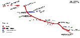
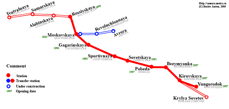
. Opened in 1987, it consists of one line with 9 stations and 11.4 km of bi-directional long track.
History
The city of Samara (known during Soviet times as Kuybyshev) is situated at the confluenceConfluence (geography)
In geography, a confluence is the meeting of two or more bodies of water. It usually refers to the point where two streams flow together, merging into a single stream...
of the Samara
Samara River
The Samara is a river in Russia, left tributary of Volga. The city of Samara is located at the confluence of Volga and Samara. It rises southwest of the southern end of the Ural Mountains close to the middle Ural River near the town of Orenburg. It then flows west or west northwest to meet the...
and Volga River
Volga River
The Volga is the largest river in Europe in terms of length, discharge, and watershed. It flows through central Russia, and is widely viewed as the national river of Russia. Out of the twenty largest cities of Russia, eleven, including the capital Moscow, are situated in the Volga's drainage...
s. Being an important junction of several waterways and railways, the city grew rapidly during the 20th century simultaneously becoming an important industrial centre. In the late 1970s its population exceeded a million passing the legal Soviet requirement to begin developing a rapid-transit system.
The design plan for Kuybyshev was based on the standard Soviet triangle arrangement, but with provisions to suit the dynamics of Kuybyshev, whose business, commercial and historical centre is situated on the edge, on the bank of the Volga River
Volga River
The Volga is the largest river in Europe in terms of length, discharge, and watershed. It flows through central Russia, and is widely viewed as the national river of Russia. Out of the twenty largest cities of Russia, eleven, including the capital Moscow, are situated in the Volga's drainage...
. Whilst the edges of the city were located with industrial zones and Soviet bedroom regions. Most of the central regions (the geographical centre) between the areas were flats built primarily for the workers. It was also the central area which experienced the most concentrated congestion.
In the finalized plan, the first stage was to pass under this central artery and then expand westwards towards following the bank of the Volga around the commercial zone and eventually terminating at the city's central railway terminal. Construction began in 1980, on the first four station stretch totaling 4.5 km. On December 25, 1987 the system was triumphantly opened to the public becoming the fifth such in Russia and the twelfth of the former Soviet Union
Soviet Union
The Soviet Union , officially the Union of Soviet Socialist Republics , was a constitutionally socialist state that existed in Eurasia between 1922 and 1991....
.
Immediately after the opening of the first stage, which despite its modest size (compared to other Soviet systems) the Metro was overladen with passengers. Construction of the second stage began shortly however, this was slowed down with the disintegration of the Soviet Union
Soviet Union
The Soviet Union , officially the Union of Soviet Socialist Republics , was a constitutionally socialist state that existed in Eurasia between 1922 and 1991....
and the chaotic economic hardships that followed. Originally scheduled to open in 1991, the next three station 4.5 km segment opened slowly, one station at a time from December 1992 to December 1993.
Despite the economic stagnation
Economic stagnation
Economic stagnation or economic immobilism, often called simply stagnation or immobilism, is a prolonged period of slow economic growth , usually accompanied by high unemployment. Under some definitions, "slow" means significantly slower than potential growth as estimated by experts in macroeconomics...
, the system managed to grow to length that allowed it to carry out its major transport role, unlike the ill-fated Nizhny Novgorod
Nizhny Novgorod Metro
The Nizhny Novgorod Metro , formerly known as Gorky Metro is a rapid-transit system that serves the city of Nizhny Novgorod, Russia. Opened in 1985, it consists of 13 stations and is 15.3 kilometres long.-History:...
and Yerevan
Yerevan Metro
The Yerevan Metro is a rapid transit system that serves the capital of Armenia, Yerevan. The system was launched in 1981 and like most former Soviet Metros, its stations are very deep and intricately decorated with national motifs. The metro runs on a 13.4km line and currently services 10 active...
Metros throughout the 1990s.
Construction on the third planned stage, originally destined for the second half of the 1990s began in 1991, was extremely slow because of constant offsets. The first station opened in December 2002, the second following five years later in 2007.
Timeline
| Segment | Date opened | Length |
|---|---|---|
| Yungorodok-Pobeda | December 26, 1987 | 4.5 km |
| Pobeda - Sovetskaya | December 31, 1992 | 1.6 km |
| Sovetskaya-Sportivnaya | March 25, 1993 | 1.4 km |
| Sportivnaya-Gagarinskaya | December 30, 1993 | 1.5 km |
| Gagarinskaya-Moskovskaya | December 12, 2002 | 1.3 km |
| Moskovskaya–Rossiyskaya | December 26, 2007 | 1.1 km |
| Total: | 9 stations | 11.4 km |
Operation
The system is operated by a municipal company Samarsky Metropoliten that was privatised from the Russian Ministry of Rail services back in the early 1990s1990s
File:1990s decade montage.png|From left, clockwise: The Hubble Space Telescope floats in space after it was taken up in 1990; American F-16s and F-15s fly over burning oil fields and the USA Lexie in Operation Desert Storm, also known as the 1991 Gulf War; The signing of the Oslo Accords on...
. The company is responsible for all management of the system, including management and repairs of tunnel and track, rolling stock
Railroad car
A railroad car or railway vehicle , also known as a bogie in Indian English, is a vehicle on a rail transport system that is used for the carrying of cargo or passengers. Cars can be coupled together into a train and hauled by one or more locomotives...
, stations and even planning coordination of construction works.
The rolling stock is provided by a sole Depot "Kirovskoye" which is responsible for management of all cars. Presentely there are 11 four-carriage trains assigned to the system. All of them are model 81-717/714
81-717/714
81-717/714 is a metro car designed for rapid transit systems of the Soviet Union in the middle 1970s....
although some are .5 standard.
Future
The next station, Alabinskaya, is due to follow in 2010, because of Samara Metro builders helped to finish off Kazan MetroKazan Metro
Kazan Metro is a rapid-transit system that serves the city of Kazan, Republic of Tatarstan, Russia. Opened on August 27, 2005, it is the newest system in Russia, and the first one to open after the breakup of the Soviet Union.-Planning:...
for 2005, the latter system donated its newer shield to bore the tunnels up to Alabinskaya from Rossiyskaya. From there the system will continue towards the historical centre towards the central theatre, located not far from the influx of Samarka into the Volga.
On the other end of the line, the station Yungorodok, which was intended to be a temporary station, will be liquidated and a new extension be built to Krylya Sovetov. This would finish the first line and is expected to take place by 2015. Further plans include a second and a third line for the systems, and both Gagarinskaya and Moskovskaya have clear provisions for a future transfer.