

Sai-ji
Encyclopedia
Buddhism
Buddhism is a religion and philosophy encompassing a variety of traditions, beliefs and practices, largely based on teachings attributed to Siddhartha Gautama, commonly known as the Buddha . The Buddha lived and taught in the northeastern Indian subcontinent some time between the 6th and 4th...
temples established in Kyoto
Kyoto
is a city in the central part of the island of Honshū, Japan. It has a population close to 1.5 million. Formerly the imperial capital of Japan, it is now the capital of Kyoto Prefecture, as well as a major part of the Osaka-Kobe-Kyoto metropolitan area.-History:...
, Japan
Japan
Japan is an island nation in East Asia. Located in the Pacific Ocean, it lies to the east of the Sea of Japan, China, North Korea, South Korea and Russia, stretching from the Sea of Okhotsk in the north to the East China Sea and Taiwan in the south...
.
History
Sai-ji was founded in the early Heian periodHeian period
The is the last division of classical Japanese history, running from 794 to 1185. The period is named after the capital city of Heian-kyō, or modern Kyōto. It is the period in Japanese history when Buddhism, Taoism and other Chinese influences were at their height...
. The temple dates from 796, two years after the capital moved to Heian-kyō. Sai-ji was established together with the other temple, Tō-ji
To-ji
is a Buddhist temple of the Shingon sect in Kyoto, Japan. Its name means East Temple, and it once had a partner, Sai-ji . They stood alongside the Rashomon, the gate to the Heian capital. It is formally known as which indicates that it previously functioned as a temple providing protection for the...
(the East Temple). Each occupied a square site of approximately 300 m by 300 m situated symmetrically on both sides of the Suzaku-ōji (present-day Senbon-dōri), just north of the great Rashōmon gate
Rashomon
Rashomon may refer to:* Rashōmon, the former main city gate in two Japanese capital cities, Heijokyō and Heiankyō * Rashōmon , a short story by Ryūnosuke Akutagawa first published in 1915...
along the southern edge of the city. While Tō-ji has survived (albeit rebuilt) into modern times, Sai-ji was burnt in 990 and 1233, then abandoned and never rebuilt.
The two temples (together with Shingon-in in the imperial palace
Heian Palace
The Heian Palace was the original imperial palace of Heian-kyō , the capital of Japan, from 794 to 1227. In Japan, this palace is called Daidairi...
) were the only Buddhist institutions allowed in the capital at the time it was established. This policy was introduced by Emperor Kanmu in order to curb the political influence the large Buddhist institutions in Heijō-kyō
Heijo-kyo
Heijō-kyō , was the capital city of Japan during most of the Nara period, from 710–40 and again from 745–84. The Palace site is a listed UNESCO World Heritage together with other places in the city of Nara Heijō-kyō (平城京, also Heizei-kyō, sometimes Nara no miyako), was the capital city of Japan...
(present-day Nara
Nara, Nara
is the capital city of Nara Prefecture in the Kansai region of Japan. The city occupies the northern part of Nara Prefecture, directly bordering Kyoto Prefecture...
) had acquired during the 8th century.
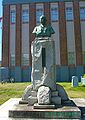
Now a small park in Minami-ku
Minami-ku, Kyoto
is one of the eleven wards in the city of Kyoto, in Kyoto Prefecture, Japan. Its name means "South Ward." It was established in 1955 when it was separated from Shimogyo-ku. As of April, 2008 the ward has an estimated population of 98,320 people. The Kamo River and the Katsura River flow through...
, Kyoto, commemorates the temple at the site.
See also
- List of Buddhist temples in Kyoto
- For an explanation of terms concerning Japanese Buddhism, Japanese Buddhist art, and Japanese Buddhist temple architecture, see the Glossary of Japanese BuddhismGlossary of Japanese BuddhismThis is the glossary of Japanese Buddhism, including major terms the casual reader might find useful in understanding articles on the subject. Words followed by an asterisk are illustrated by an image in one of the photo galleries...
.