
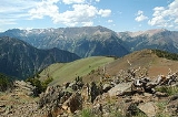
Sacajawea Peak
Encyclopedia
Sacajawea Peak is a peak in the Wallowa Mountains
, in the U.S. state
of Oregon
. It is in the Eagle Cap Wilderness
and the Wallowa–Whitman National Forest.
, and the 6th highest peak in Oregon. Matterhorn, another peak in the Wallowa Mountains, is about the same height at Sacajawea Peak, and some sources claim it is actually slightly higher.
Sacajawea's prominence of 6377 feet (1,943.7 m), makes it one of the most topographically prominent peaks in the United States
. It is ranked 18th among peaks in the 48 contiguous states
and 43rd overall. It is the 2nd most prominent peak in Oregon, after Mount Hood
.
The nearest peak higher than Sacajawea is Pinyon Peak, in the Rocky Mountains
of Idaho
, 126 mi (202.8 km) to the east. This makes Sacajawea Peak the 25th most topographically isolated
peak of the United States.
Sacajawea Peak is located in the Eagle Cap Wilderness
just northwest of Hurwal Divide, 1 miles (1.6 km) north of Matterhorn, 1.4 miles (2.3 km) northwest of Ice Lake, and 8 miles (12.9 km) south of Joseph
.
Sacajawea Peak is connected by high ridges to Matterhorn. Both are connected to Hurwal Divide, a high ridge extending east and north from Sacajawea and Matterhorn. A high pass connects Hurwal Divide to Chief Joseph Mountain, to the north. These mountains and high ridges form a unit separated from the rest of the Wallowas by river valleys, with the West Fork Wallowa River
flows north along the east edge and Hurricane Creek along the west. Numerous tributaries flow from the high mountains to these rivers. Sacajawea Peak is closer to Hurricane Creek, and several tributary streams rise on the slopes of Sacajawea, such as Thorp Creek. To the west of Sacajawea Peak, across the valley of Hurricane Creek, is the high ridge of Hurricane Divide, which separates Hurricane Creek from Lostine River
. South of the Sacajawea and Matterhorn high lands is Lake Basin, in which the Lostine River, West Fork Wallowa River, and Hurricane Creek originate among many small lakes. To the north and east of Sacajawea Peak and Chief Joseph Mountain the Wallowa Mountains come to an end at Wallowa Lake, just south of the town of Joseph
. A road runs south from Joseph along the east side of Wallowa Lake and into the valley of the Wallowa River. A number of recreation opportunities are located there, south of Wallowa Lake, including Wallowa Lake State Park
and the Wallowa Lake Tramway
on Mount Howard.
, the Shoshone
woman who traveled with the Lewis and Clark Expedition
. A proposal to change the name Sacajawea Peak to Sacagawea Peak was submitted in February 1998. In December 1999, the proposal was rejected by the United States Board on Geographic Names
.
Wallowa Mountains
The Wallowa Mountains are a mountain range located in the Columbia Plateau of northeastern Oregon in the United States. The range runs approximately 40 mi northwest to southeast in southwestern Wallowa County between the Blue Mountains to the west and the Snake River to the east. The range is...
, in the U.S. state
U.S. state
A U.S. state is any one of the 50 federated states of the United States of America that share sovereignty with the federal government. Because of this shared sovereignty, an American is a citizen both of the federal entity and of his or her state of domicile. Four states use the official title of...
of Oregon
Oregon
Oregon is a state in the Pacific Northwest region of the United States. It is located on the Pacific coast, with Washington to the north, California to the south, Nevada on the southeast and Idaho to the east. The Columbia and Snake rivers delineate much of Oregon's northern and eastern...
. It is in the Eagle Cap Wilderness
Eagle Cap Wilderness
Eagle Cap Wilderness is a wilderness area located in the Wallowa Mountains of northeastern Oregon , within the Wallowa–Whitman National Forest. The Wilderness was established in 1940. In 1964, it was included in the National Wilderness Preservation System...
and the Wallowa–Whitman National Forest.
Description
At 9838 feet (2,998.6 m), Sacajawea Peak is the highest point in the Wallowa MountainsWallowa Mountains
The Wallowa Mountains are a mountain range located in the Columbia Plateau of northeastern Oregon in the United States. The range runs approximately 40 mi northwest to southeast in southwestern Wallowa County between the Blue Mountains to the west and the Snake River to the east. The range is...
, and the 6th highest peak in Oregon. Matterhorn, another peak in the Wallowa Mountains, is about the same height at Sacajawea Peak, and some sources claim it is actually slightly higher.
Sacajawea's prominence of 6377 feet (1,943.7 m), makes it one of the most topographically prominent peaks in the United States
United States
The United States of America is a federal constitutional republic comprising fifty states and a federal district...
. It is ranked 18th among peaks in the 48 contiguous states
Contiguous United States
The contiguous United States are the 48 U.S. states on the continent of North America that are south of Canada and north of Mexico, plus the District of Columbia....
and 43rd overall. It is the 2nd most prominent peak in Oregon, after Mount Hood
Mount Hood
Mount Hood, called Wy'east by the Multnomah tribe, is a stratovolcano in the Cascade Volcanic Arc of northern Oregon. It was formed by a subduction zone and rests in the Pacific Northwest region of the United States...
.
The nearest peak higher than Sacajawea is Pinyon Peak, in the Rocky Mountains
Rocky Mountains
The Rocky Mountains are a major mountain range in western North America. The Rocky Mountains stretch more than from the northernmost part of British Columbia, in western Canada, to New Mexico, in the southwestern United States...
of Idaho
Idaho
Idaho is a state in the Rocky Mountain area of the United States. The state's largest city and capital is Boise. Residents are called "Idahoans". Idaho was admitted to the Union on July 3, 1890, as the 43rd state....
, 126 mi (202.8 km) to the east. This makes Sacajawea Peak the 25th most topographically isolated
Topographic isolation
The topographic isolation of a summit is the minimum horizontal distance to the nearest point of higher elevation. Topographic isolation represents a radius of dominance in which the summit is the highest point. Topographic isolation can be calculated for small hills and islands as well as for...
peak of the United States.
Sacajawea Peak is located in the Eagle Cap Wilderness
Eagle Cap Wilderness
Eagle Cap Wilderness is a wilderness area located in the Wallowa Mountains of northeastern Oregon , within the Wallowa–Whitman National Forest. The Wilderness was established in 1940. In 1964, it was included in the National Wilderness Preservation System...
just northwest of Hurwal Divide, 1 miles (1.6 km) north of Matterhorn, 1.4 miles (2.3 km) northwest of Ice Lake, and 8 miles (12.9 km) south of Joseph
Joseph, Oregon
Joseph is a city in Wallowa County, Oregon, United States. Originally named Silver Lake and Lake City, in 1880 the city formally named itself for Nez Perce Chief Joseph. The population was 1,054 at the 2000 census.- History :...
.
Sacajawea Peak is connected by high ridges to Matterhorn. Both are connected to Hurwal Divide, a high ridge extending east and north from Sacajawea and Matterhorn. A high pass connects Hurwal Divide to Chief Joseph Mountain, to the north. These mountains and high ridges form a unit separated from the rest of the Wallowas by river valleys, with the West Fork Wallowa River
Wallowa River
The Wallowa River is a tributary of the Grande Ronde River, approximately long, in northeastern Oregon in the United States. It drains a valley on the Columbia Plateau in the northeast corner of the state north of Wallowa Mountains. It rises in southern Wallowa County, in the Wallowa Mountains in...
flows north along the east edge and Hurricane Creek along the west. Numerous tributaries flow from the high mountains to these rivers. Sacajawea Peak is closer to Hurricane Creek, and several tributary streams rise on the slopes of Sacajawea, such as Thorp Creek. To the west of Sacajawea Peak, across the valley of Hurricane Creek, is the high ridge of Hurricane Divide, which separates Hurricane Creek from Lostine River
Lostine River
The Lostine River is a tributary of the Wallowa River in northeastern Oregon in the United States.It drains a portion of the Eagle Cap Wilderness of the Wallowa Mountains in the Wallowa-Whitman National Forest. It joins the Wallowa River at Wallowa...
. South of the Sacajawea and Matterhorn high lands is Lake Basin, in which the Lostine River, West Fork Wallowa River, and Hurricane Creek originate among many small lakes. To the north and east of Sacajawea Peak and Chief Joseph Mountain the Wallowa Mountains come to an end at Wallowa Lake, just south of the town of Joseph
Joseph, Oregon
Joseph is a city in Wallowa County, Oregon, United States. Originally named Silver Lake and Lake City, in 1880 the city formally named itself for Nez Perce Chief Joseph. The population was 1,054 at the 2000 census.- History :...
. A road runs south from Joseph along the east side of Wallowa Lake and into the valley of the Wallowa River. A number of recreation opportunities are located there, south of Wallowa Lake, including Wallowa Lake State Park
Wallowa Lake State Park
Wallowa Lake State Park is a state park located in northeast Oregon in the United States. It is at the southern shore of Wallowa Lake, near the city of Joseph in Wallowa County....
and the Wallowa Lake Tramway
Wallowa Lake Tramway
The Wallowa Lake Tramway is an aerial cable gondola lift near Joseph, Oregon, in the Wallowa-Whitman National Forest of the United States. The tram runs from the floor of the Wallowa Valley to the top of Mount Howard...
on Mount Howard.
History
Sacajawea Peak is named for SacagaweaSacagawea
Sacagawea ; was a Lemhi Shoshone woman, who accompanied the Lewis and Clark Expedition, acting as an interpreter and guide, in their exploration of the Western United States...
, the Shoshone
Shoshone
The Shoshone or Shoshoni are a Native American tribe in the United States with three large divisions: the Northern, the Western and the Eastern....
woman who traveled with the Lewis and Clark Expedition
Lewis and Clark Expedition
The Lewis and Clark Expedition, or ″Corps of Discovery Expedition" was the first transcontinental expedition to the Pacific Coast by the United States. Commissioned by President Thomas Jefferson and led by two Virginia-born veterans of Indian wars in the Ohio Valley, Meriwether Lewis and William...
. A proposal to change the name Sacajawea Peak to Sacagawea Peak was submitted in February 1998. In December 1999, the proposal was rejected by the United States Board on Geographic Names
United States Board on Geographic Names
The United States Board on Geographic Names is a United States federal body whose purpose is to establish and maintain uniform usage of geographic names throughout the U.S. government.-Overview:...
.
See also
- List of mountains of Oregon
- List of mountains of the United States
- List of mountains by elevation
- Table of the ultra-prominent summits of the United States