

SPOT (satellites)
Encyclopedia
Literal translation
Literal translation, or direct translation, is the rendering of text from one language to another "word-for-word" rather than conveying the sense of the original...
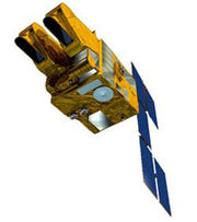
"Satellite for Earth Observation") is a high-resolution, optical imaging Earth observation satellite
Earth observation satellite
Earth observation satellites are satellites specifically designed to observe Earth from orbit, similar to reconnaissance satellites but intended for non-military uses such as environmental monitoring, meteorology, map making etc....
system operating from space. It is run by Spot Image
Spot Image
Spot Image, a public limited company created in 1982 by the French Space Agency, Centre National d'Etudes Spatiales , the IGN, and Space Manufacturers is a subsidiary of EADS Astrium...
based in Toulouse
Toulouse
Toulouse is a city in the Haute-Garonne department in southwestern FranceIt lies on the banks of the River Garonne, 590 km away from Paris and half-way between the Atlantic Ocean and the Mediterranean Sea...
, France
France
The French Republic , The French Republic , The French Republic , (commonly known as France , is a unitary semi-presidential republic in Western Europe with several overseas territories and islands located on other continents and in the Indian, Pacific, and Atlantic oceans. Metropolitan France...
. It was initiated by the CNES
CNES
The is the French government space agency . Established under President Charles de Gaulle in 1961, its headquarters are located in central Paris and it is under the supervision of the French Ministries of Defence and Research...
(Centre national d'études spatiales — the French space agency) in the 1970s and was developed in association with the SSTC (Belgian scientific, technical and cultural services) and the Swedish National Space Board
Swedish National Space Board
The Swedish National Space Board is a Swedish government agency operating under the Swedish Ministry of Education and Science. SNSB distributes government grants to research and development, initiates research and development in space and remote sensing, and is the Swedish contact in international...
(SNSB). It has been designed to improve the knowledge and management of the Earth
Earth
Earth is the third planet from the Sun, and the densest and fifth-largest of the eight planets in the Solar System. It is also the largest of the Solar System's four terrestrial planets...
by exploring the Earth's resources, detecting and forecasting phenomena involving climatology and oceanography, and monitoring human activities and natural phenomena. The SPOT system includes a series of satellites and ground control resources for satellite control and programming, image production, and distribution. The satellites were launched with the ESA rocket launcher Ariane 2, 3, and 4.
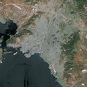
The company SPOT Image is marketing the high-resolution images, which SPOT can take from every corner of the Earth.
- SPOT 1 launched February 22, 1986 with 10 panchromaticPanchromaticPanchromatic film is a type of black-and-white photographic film that is sensitive to all wavelengths of visible light. A panchromatic film therefore produces a realistic reproduction of a scene as it appears to the human eye. Almost all modern photographic film is panchromatic, but some types are...
and 20 meter multispectral picture resolution capability. Withdrawn December 31, 1990. - SPOT 2 launched January 22, 1990 and deorbited in July 2009.
- SPOT 3 launched September 26, 1993. Stopped functioning November 14, 1997
- SPOT 4 launched March 24, 1998
- SPOT 5 launched May 4, 2002 with 2.5 m, 5 m and 10 m capability
The SPOT orbit
The SPOT orbit is polarPolar orbit
A polar orbit is an orbit in which a satellite passes above or nearly above both poles of the body being orbited on each revolution. It therefore has an inclination of 90 degrees to the equator...
, circular
Circular orbit
A circular orbit is the orbit at a fixed distance around any point by an object rotating around a fixed axis.Below we consider a circular orbit in astrodynamics or celestial mechanics under standard assumptions...
, sun-synchronous, and phased. The inclination of the orbital plane combined with the rotation of the Earth around the polar axis allows the satellite to fly over any point on Earth within 26 days. The orbit has an altitude of 832 kilometers, an inclination of 98.7°, and completing 14 + 5/26 revolutions per day.
SPOT 1, 2, and 3
Since 1986 the SPOT family of satellites has been orbiting the Earth and has already taken more than 10 million high quality images. SPOT 1 was launched with Ariane 2Ariane 2
Ariane 2 was a European expendable carrier rocket, which was used for six launches between 1986 and 1989. It was a member of the Ariane family of rockets, and was produced by Aérospatiale in France....
on February 22, 1986. Two days later, the 1800 kg SPOT 1 transmitted its first image with a spatial resolution of 10 or 20 meters. SPOT 2 joined SPOT 1 in orbit on January 22, 1990 and SPOT 3 followed on September 26, 1993.
The satellite loads were identical, each including two identical HRV (High Resolution Visible) imaging instruments that were able to operate in two modes, either simultaneously or individually. The two spectral modes are panchromatic and multispectral. The panchromatic band has a resolution of 10 meters, and the three multispectral bands (G,R,NIR) have resolutions of 20 metres. They have a scene size of 3600 km2 and a revisit interval of one to four days, depending on the latitude.
Because the orbit of SPOT 1 was lowered in 2003, it will gradually lose altitude and break up naturally in the atmosphere. Deorbitation of Spot 2 – in accordance with IADC (Inter-Agency Space Debris Coordination Committee
Inter-Agency Space Debris Coordination Committee
The Inter-Agency Space Debris Coordination Committee is an inter-governmental agency whose aim is to co-ordinate efforts to deal with debris in orbit around the Earth founded in 1993.-Members:*Agenzia Spaziale Italiana...
)- commenced in mid-July 2009 for a period of two weeks, with a final burn on 29 July 2009. SPOT 3 is not working anymore either, due to problems with its stabilization system.
SPOT 4
SPOT 4 was launched on March 24, 1998 and features major improvements over SPOT 1, 2, and 3. The principal feature was the modification of the HRV, becoming a high-resolution visible and infrared (HRVIR) instrument. It has an additional band at mid-infrared wavelengths (1.58-1.75 micrometres), intended to provide capabilities for geological reconnaissance, vegetation surveys, and survey of snow cover.SPOT 5
SPOT 5 was launched on May 4, 2002 and has the goal to ensure continuity of services for customers and to improve the quality of data and images by anticipating changes in market requirements.SPOT 5 has two high resolution geometrical (HRG) instruments that were deduced from the HRVIR of SPOT 4. They offer a higher resolution of 2.5 to 5 meters in panchromatic mode and 10 meters in multispectral mode (20 metre on short wave infrared 1.58 - 1.75 µm). SPOT 5 also features an HRS imaging instrument operating in panchromatic mode. HRS points forward and backward of the satellite. Thus, it is able to take stereopair images almost simultaneously to map relief.
SPOT 6 and SPOT 7
SPOT 6 and SPOT 7 launches are scheduled for 2012 and 2013, respectively. They form a constellation of Earth-imaging satellites designed to provide continuity of high-resolution, wide-swath data up to 2023. EADS AstriumEADS Astrium
Astrium Satellites is one of the three business units of Astrium, a subsidiary of EADS. It is a European space manufacturer involved in the manufacture of spacecraft used for science, Earth observation and telecommunication, as well as the equipment and subsystems used therein and related ground...
took the decision to build this constellation in 2009 on the basis of a perceived government need for this kind of data. Spot Image, a subsidiary of Astrium, is funding the satellites alone and owns the system (satellites and ground segments).
- The architecture is similar to that of the Pleiades satellitesPleiades satellitesThe Pléiades constellation is composed of two very-high-resolution optical Earth-imaging satellites. Pléiades 1 and Pléiades 2 will provide coverage of Earth’s surface with a repeat cycle of 26 days ....
, with a centrally mounted optical instrument, a three-axis star tracker, a fibre-optic gyro (FOG) and four control moment gyros (CMGs). - SPOT 6 and SPOT 7 will be phased in the same orbit as Pléiades 1 and Pléiades 2 at an altitude of 694 km.
- Image product resolution:
- Panchromatic: 1.5 m
- Colour merge: 1.5 m
- Multispectral: 8 m
- Spectral bands, with simultaneous panchromatic and multispectral acquisitions:
- Panchromatic (450 – 745 nm)
- Blue (450 – 525 nm)
- Green (530 – 590 nm)
- Red (625 – 695 nm)
- Near-infrared (760 – 890 nm)
- Footprint: 60 km x 60 km
- Responsive satellite tasking, with 6 tasking plans per day, per satellite
- Capacity to acquire up to 3 million km2. daily