

Río Plátano Biosphere Reserve
Encyclopedia
The Río Plátano Biosphere Reserve is 5,250 km² of preserved land in the La Mosquitia
region on the Caribbean coast of Honduras
. Most of the land runs along the Río Plátano
. The reserve has a number of endangered species and some of Honduras largest sections of forest. It has been a World Heritage site and biosphere reserve since 1982. The reserve encompasses both mountainous and lowland tropical rainforest, full of diverse wildlife and plant life, and has more than 2000 inhabitants. The reserve is part of the Mesoamerican Biological Corridor
that stretches from Mexico southwards trough Central America.
Although the reserve covers a large portion of Honduras, very little is recorded about the biological diversity within it. While previous management plans have proven successful, a continued investigation into ongoing management plans and future conservation issues will be necessary to keep this valuable reserve safe. Currently there are threats to the conservation of the reserve which include illegal hunting, logging and clearing of land to graze cattle. Recent rafting expeditions from the Rio Platano headwaters through all three zones of the reserve (cultural, buffer and core)have documented cattle grazing in the core zone,commercial fishing and hunting camps along the river and clear cutting of forest near Las Marias.
Ciudad Blanca was a Mayan city that once stood where the reserve currently protects. The archeological site is still being excavated.
Ciudad Blanca is a mythological site such as Atlantis or El Dorado. As to conjectures on who built the city no one knows. Everyone from extra-terrestrial aliens to Aztecs have been attributed to the building of this site. However no one can say that any of the ruins discovered/found there currently are conclusively and without a doubt the famed Ciudad Blanca.
Few of these sites are protected, in fact some have been looted and many are a significant factor for tourism. Although the archeological value of the region initially played a large part in the formation of the reservation, the reservation currently focuses mostly on the protection of the forests.
. The smaller groups, the Pech, Garifunas, and Miskito inhabitants live mostly in the north, alongside the river. These people have a variety of rights to the land and mostly use the land for agriculture. The smaller-scale agriculture of the Pech is easily made sustainable. Many of the largest group, the ladino, entered the reserve from the south. Conflict over land rights is a prominent source of conflict between ethnic groups. Current conflict over land rights involve non native peoples invading and threatening indigenous land owners forcing them from their historical lands.
The area is protected by policy from the Department of Protected Areas & Wildlife, State Forestry Administration in Honduras, and receives some funding from the World Wildlife Fund and other private organizations. A number of governmental and non-governmental organizations and committees have developed and implemented conservation plans in the region. The main goal of the reserve is to protect the land from deforestation and development.
The reserve’s conservation plan also aims to integrate local inhabitants into their environment via sustainable agricultural practices. Indigenous populations play a large part into the success of the conservation plan, both inside the reservation and outside the reservation in the buffer zones. Assigning titles and recognizing de facto property rights played an important part of the beginning of the conservation plan in the reserve. There is currently a need to update any conservation plan for the reserve.
A reserve management plan, implemented in 2000, included macrozoning, subzoning, and specific plans for conservation issues. The macrozoning plan established buffer zones, cultural zones, and nucleus zones. The overall threat, especially in the nucleus zones, had decreased in 2006 leading to the removal of the World Heritage in Danger designation in 2007.
The conservation plan also requests continued commitment to clarifying land ownership in and around the reserve. More research needs to be done to understand the value of the reserve and the potential threats it faces. There are currently no park guards or any official entity actively patrolling or guarding the reserve.
The reserve also receives an average of four severe tropical storms every ten years. The tropical storms echo through the rest of the reserve through the numerous waterways. Development plans and agriculture depend upon the river’s natural levees to drain water from low-lying areas. The after-effects of the Hurricane Mitch
in 1998 disrupted the development of the Patuca II hydroelectric facility.
. The reserve is mostly mountainous, including Pico Dama, a giant granite formation, and Punta Piedra, the highest peak at 1326 m (4,350.4 ft).
The reserve includes nearly the entire watershed of the Río Plátano, and many other smaller waterways. Much the region is covered with mountainous terrain. The rivers wind through both the lower and mountainous regions. The forms many oxbows as it crosses the long stretch of flat lowland that separates the foothills from the lagoons. The river has created oxbow lakes, marshes, and natural levees.
The geography of the region makes agriculture and conservation especially complicated. The low-land areas covered with water throughout the winter, and the rivers and the various tributaries house a wide variety of flora. The coastal region to the north is more commonly documented, so the rest of the region needs more thorough exploration.
 The reserve contains part of the largest surviving area of undisturbed tropical rainforest in Honduras and one of the few remaining in Central America, with numerous endangered species. Although there is a growing amount of research available on the biodiversity within the reserve, the current management plans emphasize the need for more research on the flora and fauna of the region.
and freshwater swamps and marshes, sedge prairie, pine savanna, and gallery forest. There is a diverse amount of flora, estimated at over 2,000 species of vascular plants, although little has been written about it because many species are new or undiscovered.
 There are two major mangrove ecosystems along the coast: the Brus Lagoon and the Iban Lagoon. The Brus area is 120 km² and brackish, and the Ibans area is 63 km² and freshwater. The mangroves are valuable and fragile, so they are a significant part of the value of the reserve.
 Further in, the land becomes prairie and savannah with pine and palm, depending upon the availability of water. Along the watershed of the rivers, the vegetation is thick wet forest, which is again, unfortunately poorly studied.
, harpy eagle, Great Curassow
, crested guan
, scarlet macaw
, green macaw and military macaw
.
 The representative species include White-headed Capuchin
, mantled howler
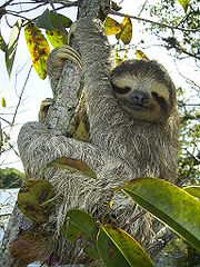
and spider monkeys, Brown-throated Sloth, paca
, kinkajou
, coati
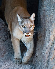
mundi tayra, Central American otter, puma, collared peccary
, white-lipped peccary
and red brocket
.
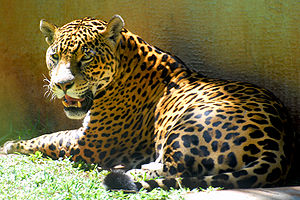
, jaguar
, ocelot
, margay
, Caribbean West Indian manatee
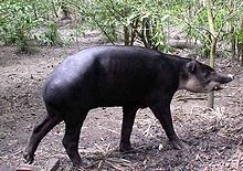
, and Central American tapir.
The amount of environmental education that exists in Honduras is minimal, so it is difficult to protect these endangered species. The widespread poverty and lack of accurate research on the ecosystems makes protection increasingly difficult. While the conservation programs are reaching their goals, it is difficult to tell whether or not the management plans are successfully protecting these species directly. Protecting the ecosystems, like the rainforest, upon which the endangered species depend serves as an important indirect benefit.
coast makes it a popular destination for ecotourists. Although private organizations are launching ecotourism enterprises throughout the region, the government does not have a comprehensive plan to control or benefit from ecotourists. Ecotourism can offer relief for poverty stricken local populations, increased awareness of biological value, and can generate income that can be used to fund projects for the reserve. Currently there are guided 10-12 day rafting trips being offered down the entire length of the Rio Platano.
Although a properly implemented tourist industry could benefit the reserve, the currently unregulated industry has created a large amount of traffic and damaged archeological sites. The tourism industry has an impact across the entire reserve, but the unprotected archeological sites are especially hurt. Without developing infrastructure, it is difficult to have a profitable and sustainable ecotourism industry, especially in a reserve with difficult conservation issues.
Local populations admit that a large amount mahogany is leaving the reserve, but many poorer sections of the economy see the high price of mahogany as enough incentive to clear away valuable ecosystems that provide irreplaceable services to the water and soil. The loggers behind much of the reserve’s deforestation is still mostly unknown.
In order to curb the logging problems, the reserve needs to establish stricter regulations. When logs are typically transported out through waterways, it should be relatively easy to monitor the logging activity. If the local populations were also better informed on the importance of the forests, alternative ways to earn a living, and more sustainable methods of extracting mahogany, the problem could be addressed. The current management plan establishes more organization to approach the logging problem as it approaches.
Agriculture throughout the reserve poses a more direct threat. As the populations expand within the reserve, so do their agricultural operations. Much of the wetland area is unsuitable for agriculture, needing levees and continued development to be productive. Much of the non-legal de facto ownership has spurred conflict, sometimes violent, among different cultural groups over rights to agriculturally productive areas.
Poorer farmers resort to destructive techniques, like slash-and-burn, that are particularly damaging to the savannah and prairie land. Although the current management plan aims to educate farmers about these destructive practices, they continue. Future management goals aim to promote sustainable technique among a larger number of the traditional farmers.
Currently, the Honduran Corporation for Forestry Development with the help of the Honduran Public Safety Force polices the reserve, hoping to decrease the number of people who invade. Regardless of their efforts, refugees continue to enter. The reservation considered a plan to relocate refugees outside the reserve, creating both an increased buffer and reducing the stress within the reserve. This plan was met with political opposition.
La Mosquitia
La Mosquitia refers to the northeastern part of Honduras along the Mosquito Coast. It is an underdeveloped region of tropical rainforest accessible primarily by water and air. Its population include indigenous groups such as the Miskito, the Pech, Rama, Sumo, and Tawakha. The Río Plátano Biosphere...
region on the Caribbean coast of Honduras
Honduras
Honduras is a republic in Central America. It was previously known as Spanish Honduras to differentiate it from British Honduras, which became the modern-day state of Belize...
. Most of the land runs along the Río Plátano
Plátano River
The Plátano River is a river in Honduras which runs through the Río Plátano Biosphere Reserve.-References:*Rand McNally, The New International Atlas, 1993.*CIA map: :Image:Honduras rel 1985.jpg*UN map: :Image:Un-honduras.png*...
. The reserve has a number of endangered species and some of Honduras largest sections of forest. It has been a World Heritage site and biosphere reserve since 1982. The reserve encompasses both mountainous and lowland tropical rainforest, full of diverse wildlife and plant life, and has more than 2000 inhabitants. The reserve is part of the Mesoamerican Biological Corridor
Mesoamerican Biological Corridor
The Mesoamerican Biological Corridor is a large habitat corridor in Mesoamerica, stretching from Mexico southeastward through most of Central America, connecting several national parks. It was started in 1998 to keep 106 critically endangered species from going extinct...
that stretches from Mexico southwards trough Central America.
Although the reserve covers a large portion of Honduras, very little is recorded about the biological diversity within it. While previous management plans have proven successful, a continued investigation into ongoing management plans and future conservation issues will be necessary to keep this valuable reserve safe. Currently there are threats to the conservation of the reserve which include illegal hunting, logging and clearing of land to graze cattle. Recent rafting expeditions from the Rio Platano headwaters through all three zones of the reserve (cultural, buffer and core)have documented cattle grazing in the core zone,commercial fishing and hunting camps along the river and clear cutting of forest near Las Marias.
History
In 1969, the land was set aside as an archaeological national park. A management and development was designed in 1980 and implemented in 1987 by the Department of Natural Renewable Resources. In 1997, an additional 3250 km² was designated as a buffer zone for the reserve. In 1997 the German Development Bank began a plan that would significantly expand the reserve to the Patuca River and the Bosawas Biosphere Reserve in Nicaragua. Currently, the German plan has been delayed.Archeological sites
The reserve still has over 200 archeological sites, including the point where Christopher Columbus first arrived in mainland America. The reserve also contains Mayan ruins, including stone from buildings and roads, rock carvings, and other remains.Ciudad Blanca was a Mayan city that once stood where the reserve currently protects. The archeological site is still being excavated.
Ciudad Blanca is a mythological site such as Atlantis or El Dorado. As to conjectures on who built the city no one knows. Everyone from extra-terrestrial aliens to Aztecs have been attributed to the building of this site. However no one can say that any of the ruins discovered/found there currently are conclusively and without a doubt the famed Ciudad Blanca.
Few of these sites are protected, in fact some have been looted and many are a significant factor for tourism. Although the archeological value of the region initially played a large part in the formation of the reservation, the reservation currently focuses mostly on the protection of the forests.
Local population
The reserve is home for more than 2,000 indigenous people and a growing number of migrant inhabitants. The population includes four very different and unique cultural groups: Miskito, Pech, Garifunas, and the ladinoLadino people
Ladino is a Spanish term used to describe various socio-ethnic categories in Latin America, principally in Central America.The term Ladino is derived from "latino" and usually refers to the mestizo or hispanicized population...
. The smaller groups, the Pech, Garifunas, and Miskito inhabitants live mostly in the north, alongside the river. These people have a variety of rights to the land and mostly use the land for agriculture. The smaller-scale agriculture of the Pech is easily made sustainable. Many of the largest group, the ladino, entered the reserve from the south. Conflict over land rights is a prominent source of conflict between ethnic groups. Current conflict over land rights involve non native peoples invading and threatening indigenous land owners forcing them from their historical lands.
Conservation
In 1996 the reserve received the World Heritage in Danger designation, but was removed from the list in 2007 recognizing a significant improvement in conservation efforts. This removal recognizes the substantial improvement in the conservation efforts in the reservation. However,from recent investigations in 2010 and 2011 it appears that what ever gains were initially recognized, that is not the case currently. UNESCO recently (2011) did a mission to the Rio Platano and found illegal activity within the core zone. Clearing of land for cattle grazing and illegal fishing and hunting along the river is currently happening.The area is protected by policy from the Department of Protected Areas & Wildlife, State Forestry Administration in Honduras, and receives some funding from the World Wildlife Fund and other private organizations. A number of governmental and non-governmental organizations and committees have developed and implemented conservation plans in the region. The main goal of the reserve is to protect the land from deforestation and development.
The reserve’s conservation plan also aims to integrate local inhabitants into their environment via sustainable agricultural practices. Indigenous populations play a large part into the success of the conservation plan, both inside the reservation and outside the reservation in the buffer zones. Assigning titles and recognizing de facto property rights played an important part of the beginning of the conservation plan in the reserve. There is currently a need to update any conservation plan for the reserve.
A reserve management plan, implemented in 2000, included macrozoning, subzoning, and specific plans for conservation issues. The macrozoning plan established buffer zones, cultural zones, and nucleus zones. The overall threat, especially in the nucleus zones, had decreased in 2006 leading to the removal of the World Heritage in Danger designation in 2007.
The conservation plan also requests continued commitment to clarifying land ownership in and around the reserve. More research needs to be done to understand the value of the reserve and the potential threats it faces. There are currently no park guards or any official entity actively patrolling or guarding the reserve.
Climate
The annual precipitation is between 2850 and 4000 mm (112.2 and 157.5 in), and the local inhabitants have noticed a trend towards dryer seasons. The climate in the region is key to preserving the valuable wet forests and important for the agriculture upon which the indigenous people depend.The reserve also receives an average of four severe tropical storms every ten years. The tropical storms echo through the rest of the reserve through the numerous waterways. Development plans and agriculture depend upon the river’s natural levees to drain water from low-lying areas. The after-effects of the Hurricane Mitch
Hurricane Mitch
Hurricane Mitch was the most powerful hurricane and the most destructive of the 1998 Atlantic hurricane season, with maximum sustained winds of 180 mph . The storm was the thirteenth tropical storm, ninth hurricane, and third major hurricane of the season. Along with Hurricane Georges, Mitch...
in 1998 disrupted the development of the Patuca II hydroelectric facility.
Geography
The land stretches from La Moskitia coast through lagoons and along the Río Plátano up into the mountains. The buffer area also includes the Paulaya and Sico valley, and will eventually extend to the Patuca RiverPatuca River
The Patuca is a river in northeastern Honduras, formed southeast of Juticalpa by the merger of the Guayape and Guayambre rivers. It is the second largest river in Central America....
. The reserve is mostly mountainous, including Pico Dama, a giant granite formation, and Punta Piedra, the highest peak at 1326 m (4,350.4 ft).
The reserve includes nearly the entire watershed of the Río Plátano, and many other smaller waterways. Much the region is covered with mountainous terrain. The rivers wind through both the lower and mountainous regions. The forms many oxbows as it crosses the long stretch of flat lowland that separates the foothills from the lagoons. The river has created oxbow lakes, marshes, and natural levees.
The geography of the region makes agriculture and conservation especially complicated. The low-land areas covered with water throughout the winter, and the rivers and the various tributaries house a wide variety of flora. The coastal region to the north is more commonly documented, so the rest of the region needs more thorough exploration.
Flora and fauna
Flora
The major ecosystems include MangroveMangrove
Mangroves are various kinds of trees up to medium height and shrubs that grow in saline coastal sediment habitats in the tropics and subtropics – mainly between latitudes N and S...
and freshwater swamps and marshes, sedge prairie, pine savanna, and gallery forest. There is a diverse amount of flora, estimated at over 2,000 species of vascular plants, although little has been written about it because many species are new or undiscovered.
Fauna
The documented fauna of the region includes 39 species of mammals, 377 species of birds and 126 species of reptiles and amphibians. The region is rich with birds, including the king vultureKing Vulture
The King Vulture is a large bird found in Central and South America. It is a member of the New World vulture family Cathartidae. This vulture lives predominantly in tropical lowland forests stretching from southern Mexico to northern Argentina, though some believe that William Bartram's Painted...
, harpy eagle, Great Curassow
Great Curassow
The Great Curassow is a large, pheasant-like bird from the Neotropics. At in length and in weight, this is a very large cracid. No other cracid match its maximum weight, but its length is matched by a few other cracids....
, crested guan
Crested Guan
The Crested Guan, Penelope purpurascens, is a member of an ancient group of birds of the Cracidae family, which are related to the Australasian mound builders. It breeds in lowlands from south Mexico and the Yucatán Peninsula to western Ecuador and southern Venezuela at up to 1850 m altitude.The...
, scarlet macaw
Scarlet Macaw
The Scarlet Macaw is a large, colorful macaw. It is native to humid evergreen forests in the American tropics. Range extends from extreme south-eastern Mexico to Amazonian Peru, Bolivia and Brazil in lowlands up to up to...
, green macaw and military macaw
Military Macaw
The Military Macaw is a large parrot and a medium-sized member of the macaw genus. Though considered vulnerable as a wild species, it is still commonly found in the pet trade industry. A predominantly green bird, it is found in the forests of Mexico and South America.-Taxonomy:There are three...
.
White-headed Capuchin
The white-headed capuchin , also known as the white-faced capuchin or white-throated capuchin, is a medium-sized New World monkey of the family Cebidae, subfamily Cebinae...
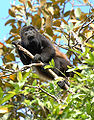
, mantled howler
Mantled Howler
The mantled howler , or golden-mantled howling monkey, is a species of howler monkey, a type of New World monkey, from Central and South America. It is one of the monkey species most often seen and heard in the wild in Central America...
and spider monkeys, Brown-throated Sloth, paca
Paca
The Lowland Paca , also known as the Spotted Paca, is a large rodent found in tropical and sub-tropical America, from East-Central Mexico to Northern Argentina...
, kinkajou
Kinkajou
The kinkajou , also known as the honey bear , is a rainforest mammal of the family Procyonidae related to olingos, coatis, raccoons, and the ringtail and cacomistle. It is the only member of the genus Potos. Kinkajous may be mistaken for ferrets or monkeys, but are not closely related...
, coati
Coati
Coatis, genera Nasua and Nasuella, also known as the Brazilian aardvark, Mexican tejón, hog-nosed coon, pizotes, crackoons and snookum bears, are members of the raccoon family . They are diurnal mammals native to South America, Central America, and south-western North America...
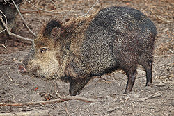
mundi tayra, Central American otter, puma, collared peccary
Collared Peccary
The collared peccary is a species of mammal in the family Tayassuidae that is found in North, Central, and South America. They are commonly referred to as javelina, saíno or báquiro, although these terms are also used to describe other species in the family...
, white-lipped peccary
White-lipped Peccary
The White-lipped Peccary, Tayassu pecari, is a peccary species found in Central and South America, living in rainforest, dry forest and chaco scrub. It is monotypic within the genus Tayassu....
and red brocket
Red Brocket
The Red Brocket , is a species of brocket deer from forests in South America, ranging from northern Argentina to Colombia and the Guianas...
.
Rare and endangered species
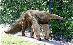
The rare or endangered species: giant anteaterGiant Anteater
The Giant Anteater, Myrmecophaga tridactyla, is the largest species of anteater. It is the only species in the genus Myrmecophaga. It is found in Central and South America from Honduras to northern Argentina...
, jaguar
Jaguar
The jaguar is a big cat, a feline in the Panthera genus, and is the only Panthera species found in the Americas. The jaguar is the third-largest feline after the tiger and the lion, and the largest in the Western Hemisphere. The jaguar's present range extends from Southern United States and Mexico...
, ocelot
Ocelot
The ocelot , pronounced /ˈɒsəˌlɒt/, also known as the dwarf leopard or McKenney's wildcat is a wild cat distributed over South and Central America and Mexico, but has been reported as far north as Texas and in Trinidad, in the Caribbean...
, margay
Margay
The Margay is a spotted cat native to Middle and South America. Named for Prince Maximilian of Wied-Neuwied, it is a solitary and nocturnal animal that prefers remote sections of the rainforest. Although it was once believed to be vulnerable to extinction, the IUCN now lists it as "Near Threatened"...
, Caribbean West Indian manatee
West Indian Manatee
The West Indian Manatee is a manatee, and the largest surviving member of the aquatic mammal order Sirenia . The West Indian Manatee, Trichechus manatus, is a species distinct from the Amazonian Manatee, T. inunguis, and the West African Manatee, T. senegalensis...
, and Central American tapir.
The amount of environmental education that exists in Honduras is minimal, so it is difficult to protect these endangered species. The widespread poverty and lack of accurate research on the ecosystems makes protection increasingly difficult. While the conservation programs are reaching their goals, it is difficult to tell whether or not the management plans are successfully protecting these species directly. Protecting the ecosystems, like the rainforest, upon which the endangered species depend serves as an important indirect benefit.
Tourism
The high density of wildlife along La MosquitiaLa Mosquitia
La Mosquitia refers to the northeastern part of Honduras along the Mosquito Coast. It is an underdeveloped region of tropical rainforest accessible primarily by water and air. Its population include indigenous groups such as the Miskito, the Pech, Rama, Sumo, and Tawakha. The Río Plátano Biosphere...
coast makes it a popular destination for ecotourists. Although private organizations are launching ecotourism enterprises throughout the region, the government does not have a comprehensive plan to control or benefit from ecotourists. Ecotourism can offer relief for poverty stricken local populations, increased awareness of biological value, and can generate income that can be used to fund projects for the reserve. Currently there are guided 10-12 day rafting trips being offered down the entire length of the Rio Platano.
Although a properly implemented tourist industry could benefit the reserve, the currently unregulated industry has created a large amount of traffic and damaged archeological sites. The tourism industry has an impact across the entire reserve, but the unprotected archeological sites are especially hurt. Without developing infrastructure, it is difficult to have a profitable and sustainable ecotourism industry, especially in a reserve with difficult conservation issues.
Conservation issues
Despite its removal from the World Heritage in Danger designation, the reserve still faces a few conservation threats. Logging and development continue to be problems, and the situation is exacerbated by an increasing population from poorer parts of Honduras or refugees from Nicaragua.Logging
The government regulates the logging industry in Honduras through the Honduran Cooperation for Forestry Development. Despite oversight of these and other organizations and a moratorium on logging inside the reserve, mahogany continues to be cut and removed. The Honduran government has failed to pass laws strict enough to have a substantial impact on preventing deforestation. The entire reserve could quickly disappear, even through unregulated deforestation.Local populations admit that a large amount mahogany is leaving the reserve, but many poorer sections of the economy see the high price of mahogany as enough incentive to clear away valuable ecosystems that provide irreplaceable services to the water and soil. The loggers behind much of the reserve’s deforestation is still mostly unknown.
In order to curb the logging problems, the reserve needs to establish stricter regulations. When logs are typically transported out through waterways, it should be relatively easy to monitor the logging activity. If the local populations were also better informed on the importance of the forests, alternative ways to earn a living, and more sustainable methods of extracting mahogany, the problem could be addressed. The current management plan establishes more organization to approach the logging problem as it approaches.
Development
Development within and around the reserve poses a problem for the conservation plans. The construction of the Patuca II hydroelectric plant in the Patuca river highlights the elements of the debate. A hydroelectric plant does more than affect the waterway where it is build. It also requires infrastructure that disturbs the environment around it. A lot of the reserve does not have developed roadways or power. A hydroelectric facility would require development throughout the reserve.Agriculture throughout the reserve poses a more direct threat. As the populations expand within the reserve, so do their agricultural operations. Much of the wetland area is unsuitable for agriculture, needing levees and continued development to be productive. Much of the non-legal de facto ownership has spurred conflict, sometimes violent, among different cultural groups over rights to agriculturally productive areas.
Poorer farmers resort to destructive techniques, like slash-and-burn, that are particularly damaging to the savannah and prairie land. Although the current management plan aims to educate farmers about these destructive practices, they continue. Future management goals aim to promote sustainable technique among a larger number of the traditional farmers.
Refugees
Conflict in Nicaragua, poverty in Honduras, and an increasing number of hurricanes have driven many refugees into the reserve, making conservation efforts increasingly complicated. These refugees often enter through the south of the reserve, and sometimes create more conflict integrating with the indigenous populations. While traditional farming practices can be somewhat destructive, the stress created by larger populations is much more damaging to the reserve.Currently, the Honduran Corporation for Forestry Development with the help of the Honduran Public Safety Force polices the reserve, hoping to decrease the number of people who invade. Regardless of their efforts, refugees continue to enter. The reservation considered a plan to relocate refugees outside the reserve, creating both an increased buffer and reducing the stress within the reserve. This plan was met with political opposition.
External links
- http://whc.unesco.org/en/news/365
- UNESCO World Heritage Site datasheet
- http://botany.si.edu/projects/cpd/ma/ma15.htm